Related Research Articles
The Holocene is the current geological epoch, beginning approximately 11,700 years ago. It follows the Last Glacial Period, which concluded with the Holocene glacial retreat. The Holocene and the preceding Pleistocene together form the Quaternary period. The Holocene is an interglacial period within the ongoing glacial cycles of the Quaternary, and is equivalent to Marine Isotope Stage 1.
The Younger Dryas, which occurred circa 12,900 to 11,700 years Before Present (BP), was a stadial (cooling) event which marked a return to glacial conditions, temporarily reversing the climatic warming of the preceding Late Glacial Interstadial. The Younger Dryas was the most severe and longest lasting of several interruptions to the warming of the Earth's climate. The end of the Younger Dryas marks the beginning of the current Holocene epoch.

Lake Bonneville was the largest Late Pleistocene paleolake in the Great Basin of western North America. It was a pluvial lake that formed in response to an increase in precipitation and a decrease in evaporation as a result of cooler temperatures. The lake covered much of what is now western Utah and at its highest level extended into present-day Idaho and Nevada. Many other hydrographically closed basins in the Great Basin contained expanded lakes during the Late Pleistocene, including Lake Lahontan in northwestern Nevada.

An endorheic basin is a drainage basin that normally retains water and allows no outflow to other, external bodies of water ; instead, the water drainage flows into permanent and seasonal lakes and swamps that equilibrate through evaporation. Endorheic basins are also called closed basins, terminal basins, and internal drainage systems.

The Last Glacial Period (LGP), also known colloquially as the Last Ice Age or simply Ice Age, occurred from the end of the Last Interglacial to the end of the Younger Dryas, encompassing the period c. 115,000 – c. 11,700 years ago.

The Last Glacial Maximum (LGM), also referred to as the Last Glacial Coldest Period, was the most recent time during the Last Glacial Period where ice sheets were at their greatest extent 26,000 and 20,000 years ago. Ice sheets covered much of Northern North America, Northern Europe, and Asia and profoundly affected Earth's climate by causing a major expansion of deserts, along with a large drop in sea levels.
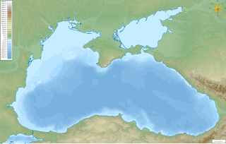
The Black Sea deluge is the best known of three hypothetical flood scenarios proposed for the Late Quaternary history of the Black Sea. One other flood scenario proposes a rapid, even catastrophic, rise in sea level of the Black Sea.
The neoglaciation describes the documented cooling trend in the Earth's climate during the Holocene, following the retreat of the Wisconsin glaciation, the most recent glacial period. Neoglaciation has followed the hypsithermal or Holocene Climatic Optimum, the warmest point in the Earth's climate during the current interglacial stage, excluding the global warming-induced temperature increase starting in the 20th century. The neoglaciation has no well-marked universal beginning: local conditions and ecological inertia affected the onset of detectably cooler conditions.
Lake Mojave is an ancient former lake fed by the Mojave River that, through the Holocene, occupied the Silver Lake and Soda Lake basins in the Mojave Desert of San Bernardino County, California. Its outlet may have ultimately emptied into the Colorado River north of Blythe.
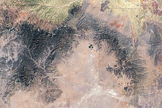
Lake Manix is a former lake fed by the Mojave River in the Mojave Desert. It lies within San Bernardino County, California. Located close to Barstow, this lake had the shape of a cloverleaf and covered four basins named Coyote, Cady/Manix, Troy and Afton. It covered a surface area of 236 square kilometres (91 sq mi) and reached an altitude of 543 metres (1,781 ft) at highstands, although poorly recognizable shorelines have been found at altitudes of 547–558 metres (1,795–1,831 ft). The lake was fed by increased runoff during the Pleistocene and overflowed into the Lake Mojave basin and from there to Lake Manly in Death Valley, or less likely into the Bristol Lake basin and from there to the Colorado River.

The Black Rock Desert volcanic field in Millard County, Utah, is a cluster of several volcanic features of the Great Basin including Pahvant Butte, The Cinders, and Tabernacle Hill. The field's Ice Springs event was an explosive eruption followed by lava flows that were Utah's most recent volcanic activity. which overlapped the older flows of Pavant Butte.
Sajsi is the name of an ancient lake in the Andes

Lake Manly is a pluvial lake in Death Valley, California. It forms occasionally in Badwater Basin after heavy rainfall, but at its maximum extent during the so-called "Blackwelder stand," ending approximately 120,000 years before present, the lake covered much of Death Valley with a surface area of 1,600 square kilometres (620 sq mi). Water levels varied through its history, and the chronology is further complicated by active tectonic processes that have modified the elevations of the various shorelines of Lake Manly; during the Blackwelder stage they reached 47–90 metres (154–295 ft) above sea level. The lake received water mainly from the Amargosa River and at various points from the Mojave River and Owens River. The lake and its substantial catchment favoured the spread of a number of aquatic species, including some lizards, pupfish and springsnails. The lake probably supported a substantial ecosystem, and a number of diatoms developed there.
Lake Palomas is a former lake in New Mexico, United States, and Chihuahua, Mexico. This lake was relatively large and reached a size of about 9,100 square kilometres (3,500 sq mi) during its highstands. Preceded by Lake Cabeza de Vaca, it formed during the Pleistocene and continued into the Holocene, when several different lake phases occurred. Presently its basin is a major source of airborne dust in the region.

Lake Panamint is a former lake that occupied Panamint Valley in California during the Pleistocene. It was formed mainly by water overflowing through the Owens River and which passed through Lake Searles into the Panamint Valley. At times, Lake Panamint itself overflowed into Death Valley and Lake Manly.

The African humid period is a climate period in Africa during the late Pleistocene and Holocene geologic epochs, when northern Africa was wetter than today. The covering of much of the Sahara desert by grasses, trees and lakes was caused by changes in the Earth's axial tilt; changes in vegetation and dust in the Sahara which strengthened the African monsoon; and increased greenhouse gases. During the preceding Last Glacial Maximum, the Sahara contained extensive dune fields and was mostly uninhabited. It was much larger than today, and its lakes and rivers such as Lake Victoria and the White Nile were either dry or at low levels. The humid period began about 14,600–14,500 years ago at the end of Heinrich event 1, simultaneously to the Bølling–Allerød warming. Rivers and lakes such as Lake Chad formed or expanded, glaciers grew on Mount Kilimanjaro and the Sahara retreated. Two major dry fluctuations occurred; during the Younger Dryas and the short 8.2 kiloyear event. The African humid period ended 6,000–5,000 years ago during the Piora Oscillation cold period. While some evidence points to an end 5,500 years ago, in the Sahel, Arabia and East Africa, the end of the period appears to have taken place in several steps, such as the 4.2-kiloyear event.

Lake Modoc is a former lake in California and Oregon, in the location of present-day Upper Klamath Lake, Lower Klamath Lake and Tule Lake. It existed during the Pliocene and Pleistocene epochs, its formation probably influenced by volcanism and faulting. The bed of the former lake had plentiful resources for early humans, and today it is used for agriculture.

Lake Alamosa is a former lake in Colorado. It existed from the Pliocene to the middle Pleistocene in the San Luis Valley, fed by glacial meltwater from surrounding mountain ranges. Water levels waxed and waned with the glacial stages until at highstand the lake reached an elevation of 2,335 meters (7,661 ft) and probably a surface of over 4,000 square kilometers (1,500 sq mi), but only sparse remains of the former waterbody are visible today. The existence of the lake was postulated in the early 19th century and eventually proven in the early 20th century.

Lake Estancia was a lake formed in the Estancia Valley, central New Mexico, which left various coastal landforms in the valley. The lake was mostly fed by creek and groundwater from the Manzano Mountains, and fluctuated between freshwater stages and saltier stages. The lake had a diverse fauna, including cutthroat trout; they may have reached it during a possible past stage where it was overflowing.
Lake San Agustín is a former lake in New Mexico, which developed as a pluvial lake in the Plains of San Agustín during Pleistocene glacial periods. During its highstands it covered an area of 1,200 square kilometres (460 sq mi) with a maximum depth of 70 metres (230 ft), and split into several separate lakes while drying out. The lake last appeared during the last glacial maximum (LGM) and dried out at the beginning of the Holocene, with the last remnant disappearing about 5,000 years ago.
References
- ↑ Hockett 2015, p. 293.
- ↑ Hockett 2015, p. 299.
- 1 2 3 Pettigrew, Richard M. (1984). "Prehistoric Human Land-use Patterns in the Alvord Basin, Southeastern Oregon". Journal of California and Great Basin Anthropology. 6 (1): 82–83. JSTOR 27825172 – via eScholarship.
- 1 2 3 4 Madsen 2000, p. 157.
- 1 2 3 4 5 6 7 Noble, Paula; Zimmerman, Susan; Ball, Ian; Adams, Kenneth; Maloney, Jillian; Smith, Shane (2016-04-01). "Late Holocene subalpine lake sediments record a multi-proxy shift to increased aridity at 3.65 kyr BP, following a millennial-scale neopluvial interval in the Lake Tahoe watershed and western Great Basin, USA". EGU General Assembly Conference Abstracts. 18: EPSC2016–7533. Bibcode:2016EGUGA..18.7533N.
- 1 2 3 Yuan, Koran & Valdez 2013, p. 155.
- 1 2 3 4 Jones, Terry L.; Klar, Kathryn; Archaeology, Society for California (2007). California Prehistory: Colonization, Culture, and Complexity. Rowman Altamira. p. 33. ISBN 9780759108721.
- 1 2 "AN EARTHQUAKE CLUSTER FOLLOWED THE DRYING OF PLEISTOCENE LAKE CHEWAUCAN, CENTRAL OREGON BASIN AND RANGE". gsa.confex.com. Retrieved 2017-07-06.
- 1 2 3 Negrini, Robert M.; Wigand, Peter E.; Draucker, Sara; Gobalet, Kenneth; Gardner, Jill K.; Sutton, Mark Q.; Yohe, Robert M. (2006-07-01). "The Rambla highstand shoreline and the Holocene lake-level history of Tulare Lake, California, USA". Quaternary Science Reviews. 25 (13): 1614. Bibcode:2006QSRv...25.1599N. doi:10.1016/j.quascirev.2005.11.014.
- 1 2 Adams, Kenneth D.; Rhodes, Edward J. (2019). "Late Pleistocene to present lake-level fluctuations at Pyramid and Winnemucca lakes, Nevada, USA". Quaternary Research. 92 (1): 24. Bibcode:2019QuRes..92..146A. doi:10.1017/qua.2018.134. ISSN 0033-5894. S2CID 135235470.
- ↑ "HOW WET CAN IT GET? DEFINING FUTURE CLIMATE EXTREMES BASED ON LATE HOLOCENE LAKE-LEVEL RECORDS". gsa.confex.com. Retrieved 2017-07-06.
- 1 2 3 Noble et al. 2016, p. 206.
- 1 2 Badger, Thomas C.; Watters, Robert J. (2004-05-01). "Gigantic seismogenic landslides of Summer Lake basin, south-central Oregon". GSA Bulletin. 116 (5–6): 619. Bibcode:2004GSAB..116..687B. doi:10.1130/B25333.1. ISSN 0016-7606.
- ↑ Ababneh, Linah; Woolfenden, Wallace (2010-03-15). "Monitoring for potential effects of climate change on the vegetation of two alpine meadows in the White Mountains of California, USA". Quaternary International. 23rd Pacific Climate Workshop (PACLIM). 215 (1): 4. Bibcode:2010QuInt.215....3A. doi:10.1016/j.quaint.2009.05.013.
- ↑ Chellman, Nathan; Pederson, Gregory T.; Lee, Craig M.; McWethy, David B.; Puseman, Kathryn; Stone, Jeffery R.; Brown, Sabrina R.; McConnell, Joseph R. (December 2020). "High elevation ice patch documents Holocene climate variability in the northern Rocky Mountains". Quaternary Science Advances. 3: 16–17. doi: 10.1016/j.qsa.2020.100021 . ISSN 2666-0334.
- 1 2 Noble et al. 2016, p. 207.
- ↑ Madsen 2000, p. 161.
- 1 2 3 Hockett 2015, p. 292.
- ↑ Oviatt & Shroder 2016, p. 363-364.
- ↑ Westfall, Robert D; Millar, Constance I (2004-08-11). "Genetic consequences of forest population dynamics influenced by historic climatic variability in the western USA". Forest Ecology and Management. Dynamics and Conservation of Genetic Diversity in Forest Ecology. 197 (1): 160. doi:10.1016/j.foreco.2004.05.011. S2CID 85791011.
- ↑ Oviatt & Shroder 2016, p. 278.
- ↑ Ababneh, Linah (2008-09-01). "Bristlecone pine paleoclimatic model for archeological patterns in the White Mountain of California". Quaternary International. The 22nd Pacific Climate Workshop. 188 (1): 63. Bibcode:2008QuInt.188...59A. doi:10.1016/j.quaint.2007.08.041.
- ↑ Hockett, Bryan; Dillingham, Eric (2023). Large-Scale Traps of the Great Basin. Texas A&M University Press. p. 37.
- ↑ Noble et al. 2016, p. 208.
- 1 2 Shuman & Serravezza 2017, p. 74.
- ↑ Yuan, Koran & Valdez 2013, p. 157.
- ↑ Liu, Tao; Ji, Lin; Baker, Victor R.; Harden, Tessa M.; Cline, Michael L. (5 February 2020). "Holocene extreme paleofloods and their climatological context, Upper Colorado River Basin, USA". Progress in Physical Geography: Earth and Environment. 44 (5): 13. doi:10.1177/0309133320904038. S2CID 213001302.
- ↑ Yuan, Koran & Valdez 2013, p. 158.
- ↑ Wilkins, David E.; Currey, Donald R. (1999-04-01). "Radiocarbon chronology andδ13C analysis of mid-to late-Holocene aeolian environments, Guadalupe Mountains National Park, Texas, USA". The Holocene. 9 (3): 368. Bibcode:1999Holoc...9..363W. doi:10.1191/095968399677728249. ISSN 0959-6836. S2CID 129122964.
Sources
- Hockett, Bryan (2015-06-01). "The zooarchaeology of Bonneville Estates Rockshelter: 13,000years of Great Basin hunting strategies". Journal of Archaeological Science: Reports. 2: 291–301. Bibcode:2015JArSR...2..291H. doi:10.1016/j.jasrep.2015.02.011.
- Madsen, David B. (2000). Late Quaternary Paleoecology in the Bonneville Basin. Utah Geological Survey. ISBN 9781557916488.
- Noble, Paula J.; Ball, G. Ian; Zimmerman, Susan H.; Maloney, Jillian; Smith, Shane B.; Kent, Graham; Adams, Kenneth D.; Karlin, Robert E.; Driscoll, Neal (2016-01-01). "Holocene paleoclimate history of Fallen Leaf Lake, CA., from geochemistry and sedimentology of well-dated sediment cores". Quaternary Science Reviews. 131, Part A: 193–210. Bibcode:2016QSRv..131..193N. doi: 10.1016/j.quascirev.2015.10.037 .
- Oviatt, Charles G.; Shroder, John F. (2016-08-24). Lake Bonneville: A Scientific Update. Elsevier. ISBN 9780444635945.
- Shuman, Bryan N.; Serravezza, Marc (2017-10-01). "Patterns of hydroclimatic change in the Rocky Mountains and surrounding regions since the last glacial maximum". Quaternary Science Reviews. 173 (Supplement C): 58–77. Bibcode:2017QSRv..173...58S. doi: 10.1016/j.quascirev.2017.08.012 .
- Yuan, Fasong; Koran, Max R.; Valdez, Andrew (2013-12-15). "Late Glacial and Holocene record of climatic change in the southern Rocky Mountains from sediments in San Luis Lake, Colorado, USA". Palaeogeography, Palaeoclimatology, Palaeoecology. 392: 146–160. Bibcode:2013PPP...392..146Y. doi:10.1016/j.palaeo.2013.09.016.