Related Research Articles

Westchester County is located in the U.S. state of New York. It is the seventh most populous county in the State of New York and the most populous north of New York City. According to the 2020 United States Census, the county had a population of 1,004,456, its highest decennial count ever and an increase of 55,344 (5.8%) from the 949,113 counted in 2010. Located in the Hudson Valley, Westchester covers an area of 450 square miles (1,200 km2), consisting of six cities, 19 towns, and 23 villages. Established in 1683, Westchester was named after the city of Chester, England. The county seat is the city of White Plains, while the most populous municipality in the county is the city of Yonkers, with 211,569 residents per the 2020 U.S. Census.

Rockland County is the southernmost county on the west side of the Hudson River in the U.S. state of New York. It is part of the New York metropolitan area. As of the 2020 U.S. census, the county's population is 338,329, making it the state's third-most densely populated county outside New York City after Nassau and neighboring Westchester Counties. The county seat and largest city is New City. Rockland County is accessible via the New York State Thruway, which crosses the Hudson to Westchester at the Tappan Zee Bridge ten exits up from the NYC border, as well as the Palisades Parkway five exits up from the George Washington Bridge. The county's name derives from "rocky land", as the area has been aptly described, largely due to the Hudson River Palisades.
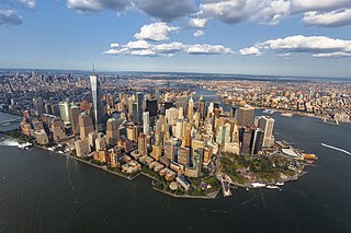
The New York metropolitan area, broadly referred to as the Tri-State area and often also called Greater New York, is the largest metropolitan area in the world by urban landmass, encompassing 4,669.0 sq mi (12,093 km2). The New York metropolitan area is one of the most populous metropolitan areas in the world, the world's largest metropolitan area by size, and the only U.S. metropolitan area larger than 20 million residents as of the 2020 United States census. The vast metropolitan area includes New York City, the nation's most populous city, Long Island, and the Mid- and Lower Hudson Valley in New York State; fourteen of twenty-one counties and the eleven largest cities in New Jersey: Newark, Jersey City, Paterson, Elizabeth, Lakewood, Edison, Woodbridge, Toms River, Hamilton, Trenton, and Clifton, along with their respective suburbs; and six of the seven largest cities in Connecticut: Bridgeport, Stamford, New Haven, Waterbury, Norwalk, and Danbury, along with the suburbs of these cities. The phrase "Tri-State area" usually refers to New York / New Jersey / Connecticut, although an increasing number of people who work in New York City commute from Pennsylvania, particularly from the Lehigh Valley, Bucks County, and Poconos regions in eastern Pennsylvania. The New York metropolitan area is the geographic and demographic hub of the larger Northeast megalopolis.
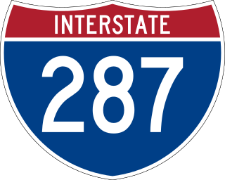
Interstate 287 (I-287) is an auxiliary Interstate Highway in the US states of New Jersey and New York. It is a partial beltway around New York City, serving northern New Jersey and the counties of Rockland and Westchester in New York. I-287, which is signed north–south in New Jersey and east–west in New York, follows a roughly horseshoe-shaped route from the New Jersey Turnpike (I-95) in Edison, New Jersey, clockwise to the New England Thruway (I-95) in Rye, New York, for 98.72 miles (158.87 km). Through New Jersey, I-287 runs west from its southern terminus in Edison through suburban areas. In Bridgewater Township, the freeway takes a more northeasterly course, paralleled by US Route 202 (US 202). The northernmost part of I-287 in New Jersey passes through mountainous surroundings. After crossing into New York at Suffern, I-287 turns east on the New York State Thruway (I-87) and runs through Rockland County. After crossing the Hudson River on the Tappan Zee Bridge, I-287 splits from I-87 near Tarrytown and continues east through Westchester County on the Cross-Westchester Expressway until it reaches the New England Thruway. Within New Jersey, I-287 is maintained by the New Jersey Department of Transportation (NJDOT), and, within New York, it is maintained by the New York State Thruway Authority (NYSTA).

A metropolitan planning organization (MPO) is a federally mandated and federally funded transportation policy-making organization in the United States that is made up of representatives from local government and governmental transportation authorities. They were created to ensure regional cooperation in transportation planning. MPOs were introduced by the Federal-Aid Highway Act of 1962, which required the formation of an MPO for any urbanized area (UZA) with a population greater than 50,000. Federal funding for transportation projects and programs are channeled through this planning process. Congress created MPOs in order to ensure that existing and future expenditures of governmental funds for transportation projects and programs are based on a continuing, cooperative, and comprehensive ("3-C") planning process. Statewide and metropolitan transportation planning processes are governed by federal law. Transparency through public access to participation in the planning process and electronic publication of plans now is required by federal law. As of 2015, there are 408 MPOs in the United States.
The Metropolitan Transportation Commission (MTC) is the government agency responsible for regional transportation planning and financing in the San Francisco Bay Area. It was created in 1970 by the State of California, with support from the Bay Area Council, to coordinate transportation services in the Bay Area's nine counties: Alameda, Contra Costa, Marin, Napa, San Francisco, San Mateo, Santa Clara, Solano, and Sonoma. The MTC is fourth most populous metropolitan planning organization in the United States.

The Metropolitan Transportation Authority Police Department (MTAPD) is the police agency of New York's Metropolitan Transportation Authority
The Massachusetts Department of Transportation (MassDOT) oversees roads, public transit, aeronautics, and transportation licensing and registration in the US state of Massachusetts. It was created on November 1, 2009, by the 186th Session of the Massachusetts General Court upon enactment of the 2009 Transportation Reform Act.
The North Carolina Capital Area Metropolitan Planning Organization (NC CAMPO) is the federally required Metropolitan Planning Organization responsible for the continuous and comprehensive transportation planning process in Wake County and parts of Franklin County, Granville County, Harnett County and Johnston County Counties. NC CAMPO is responsible for carrying out an annual work program that includes updating the Metropolitan Transportation Improvement Program (a seven-year project programming schedule) and the Long-Range Transportation Plan (a minimum twenty-year forecast of projects and programs).
Transportation in Erie, Pennsylvania includes access to most major forms of transportation, including automobile, bus, train, taxi, airplane, and ship. The city generates income through the transportation industry, including train manufacturing and port operations.
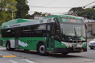
The Transport of Rockland (TOR) is the bus system for Rockland County, New York, providing service along major routes in Rockland County, as well as connections to Clarkstown Mini-Trans in Clarkstown, Spring Valley Jitney in Spring Valley, the Bee-Line Bus System in Westchester as well as connections to Rockland Coaches and Short Line Bus routes providing commuter and local service to Northern New Jersey and New York City's Port Authority Bus Terminal, George Washington Bridge Bus Station, 5th Avenue, and Long Island. Annual ridership in 2008 was 3,862,232.

The Long Island Sound link is a proposed bridge or tunnel that would link Long Island, New York, to Westchester County or Connecticut, across Long Island Sound east of the Throgs Neck Bridge. The project has been studied and debated since the mid-20th century. The most recent proposal is a tunnel between Rye, New York, on the mainland and Oyster Bay on the island. Feasibility studies for bridges and tunnels have been conducted for numerous entry points, as listed in the chart below.
The Tri-State Transportation Campaign (TSTC) is a non-profit advocacy and policy organization dedicated to reducing car and truck dependency and promoting a "more balanced, environmentally sound and equitable transportation network" in downstate New York, New Jersey and Connecticut. TSTC's methods include political and media advocacy including a self-published blog, original research and analysis, litigation, and community organizing.
The North Jersey Transportation Planning Authority (NJTPA) is the federally authorized metropolitan planning organization (MPO) for the 13-county northern New Jersey region, one of three MPOs in the state. NJTPA's annual budget is more than $2 billion for transportation improvement projects. The Authority also participates in inter-agency cooperation and receives public input into funding decisions. The NJTPA sponsors and conducts studies, assists county planning agencies and monitors compliance with national air quality goals. The Authority provides federal funding to support the planning work of its 15 subregions. The funds are matched by a local contribution. As vital partners in regional planning work, the subregions help bring a local perspective to all aspects of NJTPA's work to improve the northern New Jersey transportation network.
There are three metropolitan planning organizations (MPO) in New Jersey. The organizations are the main decision-making forums for selecting projects for the Statewide Transportation Improvement Program (STIP) in deliberations involving the New Jersey Department of Transportation (NJDOT), the New Jersey Transit Corporation (NJT), county and municipal transportation planners and engineers, other transportation implementing agencies, the public and elected officials at the state, county, and municipal levels.

Bus rapid transit in New Jersey comprises limited-stop bus service, exclusive bus lanes (XBL) and bus bypass shoulders (BBS). Under the banner Next Generation Bus New Jersey Transit (NJT), the New Jersey Department of Transportation (NJDOT), and the metropolitan planning organizations of New Jersey (MPO) which recommend and authorize transportation projects are undertaking the creation of several additional bus rapid transit systems (BRT) in the state.

The New York metropolitan area has the busiest airport system in the United States and the second busiest in the world after London. It is also the most frequently used port of entry and departure for international flights. In 2011, more than 104 million passengers used the airports under the auspices of the Port Authority of New York and New Jersey (PANYNJ). The number increased to 117 million in 2014.
References
- ↑ "Federal Transit Administration - NYMTC Planning Certification Review". www.fta.dot.gov. Archived from the original on 2010-05-27.
- ↑ Miller, steven (September 6, 2016). "Is Tri-State Transportation Too Big to Plan?". The Village Voice. Retrieved 8 September 2016.
- ↑ Plotch, Philip Mark. Politics Across the Hudson: The Tappan Zee Megaproject. Rutgers University Press, New Jersey (2015). p. 21
- ↑ "NYMTC".