Newcastle City Centre

Last updated

Newcastle City Centre skyline All Saints - geograph.org.uk - 1640047.jpg
Newcastle City Centre skyline
Newcastle City Centre panorama St James Park Newcastle as seen from south of the River Tyne.jpg
Newcastle City Centre panorama

Newcastle City Centre is the city centre district of Newcastle upon Tyne, England. It is the historical heart of the city and serves as the main cultural and commercial centre of the North East England region. The city centre forms the core of the Tyneside conurbation.

Contents

The city centre district is sometimes subdivided into the areas of Haymarket, Quayside, Grainger Town, Monument, Gallowgate, and Chinatown.

Areas

Haymarket

Newcastle Civic Centre, Haymarket Newcastle Civic Centre.JPG
Newcastle Civic Centre, Haymarket

Haymarket is the northern edge of the city centre bordered by Spital Tongues and Jesmond to the north west and north east respectively. It is the location of Newcastle Civic Centre, Newcastle University, Northumbria University, Haymarket bus station and the City Pool, and is mainly a business area. The Church of St Thomas the Martyr is a prominent landmark in the area opposite the Metro station at the northern end of Northumberland Street, the city's main shopping street.

Quayside

Quayside Newcastle Upon Tyne bridges.jpg
Quayside

The Quayside is a more modern part of Newcastle city centre known for its bars and restaurants.

Four bridges cross the River Tyne at the Quayside: The High Level Bridge, the Swing Bridge, the Tyne Bridge and the Gateshead Millennium Bridge.

The QuayLink bus route links the area with Monument and Haymarket and Central station, Gateshead metro stations.

The path along the river forms part of the cycle network eastwards towards North Shields and Tynemouth and westwards to Hexham.

Newcastle railway station Newcastle Central (brendada).jpg
Newcastle railway station

Central Station

Newcastle railway station, or locally known as Central station, is surrounded by an assortment of bars and clubs. Towards the western end is the city's popular Gay District known locally as the Pink Triangle. The Centre for Life on Times Square, Utilita Arena Newcastle, Newcastle Cathedral, Discovery Museum and the Mill Volvo Tyne Theatre are all located in the vicinity, as is the city's coach station.

Grainger Town

The building housing the Central Arcade GraingerMarketArea2.jpg
The building housing the Central Arcade

Grainger Town is the streets between, and encompassing, Pilgrim Street, Clayton Street and Blackett Street. It was built in the mid-19th century and, today, is an area centred on shopping, nightlife and most notable neo-classical architecture. The Theatre Royal is situated on Grey Street. The Grainger Market is a covered market built to house the traders displaced during the re-modelling of the city.[ citation needed ]

Chinatown arch Chinatown Arch Newcastle UK.jpg
Chinatown arch

Gallowgate

Gallowgate is a small area surrounding St James' Park, the stadium of Newcastle United F.C, and St James Metro station, named after the main road running through the area. There are a small number of pubs in the area but it is not a major area of residence, except for some student accommodation. Businesses include [1] and various law firms in Citygate and the recently built Time Central, a Tesco Express store, fish and sandwich shops. Behind it is Leazes Park that leads to Spital Tongues. The area is also to host a 400 square metre memorial garden to Sir Bobby Robson. Work began on it in November 2010, with it due to be opened in Spring 2011. [2] [3]

Chinatown

Chinatown is on the western edge of the city centre centred on Stowell Street with a number of Chinese restaurants and the rear entrance to The Gate.

Transport

Monument Metro station southern entrance Grey's Momument and Momument station - Newcastle upon Tyne - England - 130804.jpg
Monument Metro station southern entrance

Metro

The Tyne and Wear Metro has four stations in Newcastle city centre which are all underground. Running north to south, Haymarket, Monument and Central Station are on both the Green and Yellow lines which run northbound to the Airport or towards the coast via Whitley Bay and southbound to South Hylton or South Shields.

St James is the western terminus of the Yellow Line and precedes Monument. Trains run towards the coast via North Shields.

Bus and coach

Newcastle has two bus stations for local and regional terminating bus services. Services heading north and east generally use Haymarket bus station, whilst those to the south and west use Eldon Square bus station. Both bus stations are operated by Nexus.

Many roads in the city centre are for buses only or have bus lanes. Stagecoach is the predominant operator for bus services within the city, which tend to call at several stops in the city centre rather than at a bus station. The QuayLink service, with its bright yellow electric buses, has two routes – Q1 from Haymarket to Quayside and Q2 from Central Station to Gateshead.

For long-distance coach services, National Express uses Newcastle Coach Station on St James Boulevard, and Megabus used to stop outside Central Station. Now they stop on John Dobson Street outside the library.

Rail

Newcastle, known locally as Central, is the city's mainline railway station and a principal stop on the East Coast Main Line From there, local, regional and national destinations are served directly. Manors is the only other station in the city, but it has a very limited service. [4]

Related Research Articles

<span class="mw-page-title-main">Newcastle upon Tyne</span> City in England

Newcastle upon Tyne, or simply Newcastle, is a cathedral city and metropolitan borough in Tyne and Wear, England. It is England's northernmost metropolitan borough, located on the River Tyne's northern bank opposite Gateshead to the south. It is the most populous settlement in the Tyneside conurbation and North East England.

<span class="mw-page-title-main">Tyne and Wear</span> County of England

Tyne and Wear is a ceremonial county in North East England. It borders Northumberland to the north and County Durham to the south, and the largest settlement is the city of Newcastle upon Tyne.

<span class="mw-page-title-main">Gateshead</span> Town in Tyne and Wear, England

Gateshead is a town in the Gateshead Metropolitan Borough of Tyne and Wear, England. It is on the River Tyne's southern bank. The town's attractions include the twenty metre tall Angel of the North sculpture on the town's southern outskirts, The Glasshouse International Centre for Music and the Baltic Centre for Contemporary Art. The town shares the Millennium Bridge, Tyne Bridge and multiple other bridges with Newcastle upon Tyne.

<span class="mw-page-title-main">Tyne and Wear Metro</span> Rapid-transit rail network in north-east England

The Tyne and Wear Metro is an overground and underground light rail rapid transit system serving Newcastle upon Tyne, Gateshead, North Tyneside, South Tyneside, and the City of Sunderland. It has been described as the "first modern light rail system in the United Kingdom". The system is currently both owned and operated by the Tyne and Wear Passenger Transport Executive (Nexus), thus is fully under public ownership and operation.

<span class="mw-page-title-main">St James' Park</span> Football stadium in Newcastle upon Tyne, England

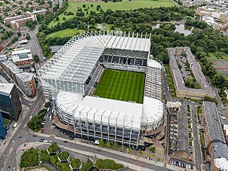
St James' Park is a football stadium in Newcastle upon Tyne, England. It is the home of Newcastle United. With a seating capacity of 52,350 seats, it is the 8th largest football stadium in England.

<span class="mw-page-title-main">Newcastle railway station</span> Mainline railway station in Newcastle upon Tyne, England

Newcastle station is a railway station in Newcastle, Tyne and Wear, England, United Kingdom. It is located on the East Coast Main Line, around 268 miles (432 km) north of London King's Cross. It is the primary national rail station serving Newcastle upon Tyne and is an interchange for local services provided by the Tyne and Wear Metro network whose Central Station is situated beneath the national rail station. It is the busiest station in Tyne & Wear, as well as the busiest in North East England.

<span class="mw-page-title-main">History of Newcastle upon Tyne</span> Development of a city in North East England

The history of Newcastle upon Tyne dates back almost 2,000 years, during which it has been controlled by the Romans, the Angles and the Norsemen amongst others. Newcastle upon Tyne was originally known by its Roman name Pons Aelius. The name "Newcastle" has been used since the Norman conquest of England. Due to its prime location on the River Tyne, the town developed greatly during the Middle Ages and it was to play a major role in the Industrial Revolution, being granted city status in 1882. Today, the city is a major retail, commercial and cultural centre.

<span class="mw-page-title-main">Haymarket Metro station</span> Tyne and Wear Metro station in Newcastle upon Tyne

Haymarket is a Tyne and Wear Metro station, serving the Haymarket area of the city of Newcastle upon Tyne in Tyne and Wear, England. It joined the network as a terminus station on 11 August 1980, following the opening of the first phase of the network, between Haymarket and Tynemouth via Four Lane Ends.

<span class="mw-page-title-main">Heworth Interchange</span> Tyne and Wear Metro and railway station in Gateshead

Heworth Interchange consists of a National Rail, Tyne and Wear Metro and bus station. It is located in the suburb of Heworth, Gateshead in Tyne and Wear, England, and opened on 5 November 1979 for rail and bus services. The station joined the Tyne and Wear Metro network around two years later, on 15 November 1981.

<span class="mw-page-title-main">Quayside</span>

The Quayside is an area along the banks (quay) of the River Tyne in Newcastle upon Tyne and Gateshead in Tyne and Wear, North East England, United Kingdom.

<span class="mw-page-title-main">Gateshead Interchange</span> Tyne and Wear Metro station in Gateshead

Gateshead Interchange is a Tyne and Wear Metro station, serving the town of Gateshead in Tyne and Wear, England. It joined the network on 15 November 1981, following the opening of the third phase of the network, between Haymarket and Heworth.

<span class="mw-page-title-main">Haymarket, Newcastle</span> Area of Newcastle, UK

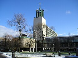
Haymarket is an area in the north of central Newcastle upon Tyne. The area has several transport hubs including Eldon Square bus station, Haymarket bus station and Haymarket Metro station. Haymarket features the facades of Newcastle Civic Centre, Newcastle University and Northumbria University. It is also the location of the Church of St Thomas the Martyr, a prominent city landmark.

Forest Hall is a village in the borough of North Tyneside, Tyne and Wear, England. It is 4 miles from Newcastle upon Tyne. It borders Killingworth to the north, Holystone to the east and Benton to the south. The village has seen a slight increase in antisocial behaviour in recent years. The village was named after the Forest Hall, which incorporated a medieval tower. Woodside Court was built on the site of the Hall, which was demolished in 1962.

<span class="mw-page-title-main">South Shields Interchange</span> Tyne and Wear Metro and bus interchange in South Tyneside

South Shields Interchange is Tyne and Wear Passenger Transport Executive's transport hub in the coastal town of South Shields, South Tyneside in Tyne and Wear, England.

<span class="mw-page-title-main">Central Station Metro station</span> Tyne and Wear Metro station in Newcastle upon Tyne

Central Station is an underground Tyne and Wear Metro station, serving the Grainger Town area of the city of Newcastle upon Tyne in Tyne and Wear, England. It joined the network on 15 November 1981, following the opening of the third phase of the network, between Haymarket and Heworth. The station is named after Newcastle Central railway station, which stands directly above it.

<span class="mw-page-title-main">Eldon Square bus station</span>

Eldon Square Bus Station is one of two bus stations serving Newcastle City Centre. It is owned by Newcastle City Council and is managed by Nexus. The new glass-roofed bus station was built adjacent to the old bus station, on a former access road, and is accessible via the new mall.

<span class="mw-page-title-main">Haymarket bus station</span>

Haymarket bus station is a bus station located in the Haymarket area of Newcastle upon Tyne. It is situated next to the Haymarket Metro station, by the northern end of Northumberland Street and almost adjacent to Newcastle University.

<span class="mw-page-title-main">QuayLink</span> Group of bus services in Tyne and Wear, England

QuayLink was a bus service in Tyne and Wear, England, which connected Gateshead and Newcastle upon Tyne, and later North Tyneside, with the Quayside. Funded by the Tyne and Wear Passenger Transport Executive, the service was launched on 22 July 2005. Operated initially by Stagecoach North East, the service was transferred to Go North East in July 2010 – later being operated commercially from July 2015, following budget cuts.

<span class="mw-page-title-main">Transport in Tyne and Wear</span> Overview of transport in Tyne and Wear

Tyne and Wear is a metropolitan area covering the cities of Newcastle upon Tyne and Sunderland, as well as North and South Tyneside, Gateshead and Washington.

<span class="mw-page-title-main">Monument, Newcastle upon Tyne</span> Ward in England

Monument is an electoral ward and area of Newcastle upon Tyne. It was established as an electoral ward in 2018. It takes its name from Grey's Monument. It replaced most of Westgate ward, parts of South Jesmond and some of Ouseburn.

References

  1. http://www.go-ne.gov.uk Archived 28 December 2008 at the Wayback Machine Government Office for the North East
  2. "Sir Bobby Robson's Tyneside garden tribute". BBC News. 26 July 2010. Retrieved 29 March 2011.
  3. "Work starts on a memorial garden to Sir Bobby Robson". BBC News. 22 November 2010. Retrieved 29 March 2011.
  4. "Station Search | Northern - Northern" (PDF).

54°58′33″N1°36′37″W / 54.9757°N 1.6103°W / 54.9757; -1.6103