
The Borough of Harrogate is a local government district and borough of North Yorkshire, England. Its population at the census of 2011 was 157,869. Its council is based in the town of Harrogate, but it also includes surrounding towns and villages. This includes the cathedral city of Ripon and almost all of the Nidderdale Area of Outstanding Natural Beauty.

Darley is a linear village in Nidderdale in the Harrogate district of North Yorkshire, England. The population as at the 2011 Census is 1,332 and is included in the civil parish of Darley and Menwith. The village extends for 1 mile east from a junction with the B6451 road. The western end of the village is known as Darley Head and the eastern end as The Holme. Darley has won many local and national 'Britain in Bloom' awards.

Skipton and Ripon is a constituency represented in the House of Commons of the UK Parliament since 2010 by Julian Smith, a Conservative.

Pateley Bridge is a small market town in Nidderdale in the Borough of Harrogate, North Yorkshire, England. Historically part of the West Riding of Yorkshire, it lies on the River Nidd. It is in the Yorkshire Dales and just outside the Yorkshire Dales National Park.

Greenhow is a village in North Yorkshire, England, often referred to as Greenhow Hill. The term how derives from the Old Norse word haugr meaning a hill and a mound, so Greenhow literally means 'Green's hill or mound'.

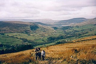
Nidderdale, historically also known as Netherdale, is one of the Yorkshire Dales in North Yorkshire, England. It is the upper valley of the River Nidd, which flows south underground and then along the dale, forming several reservoirs including the Gouthwaite Reservoir, before turning east and eventually joining the River Ouse.
The Nidderdale AONB is an Area of Outstanding Natural Beauty in North Yorkshire, England, bordering the Yorkshire Dales National Park to the east and south. It comprises most of Nidderdale itself, part of lower Wharfedale, the Washburn valley and part of lower Wensleydale, including Jervaulx Abbey and the side valleys west of the River Ure. It covers a total area of 233 square miles (600 km2). The highest point in the Nidderdale AONB is Great Whernside, 704 metres (2,310 ft) above sea level, on the border with the Yorkshire Dales National Park.
Birstwith is a village and civil parish in the Harrogate district of North Yorkshire, England. It is part of the Nidderdale, and is situated on the River Nidd. According to the 2001 census, the parish had a population of 756 and increased to 868 based on the 2011 Census.

The River Nidd is a tributary of the River Ouse in the English county of North Yorkshire. In its first few miles it is dammed three times to create Angram Reservoir, Scar House Reservoir and Gouthwaite Reservoir, which attract a total of around 150,000 visitors a year. The Nidd can overflow the reservoirs, flooding the caves in the valley. In such cases the river overflows into the normally dry river bed past Lofthouse through to Gouthwaite Reservoir. The Yorkshire Dales Rivers Trust YDRT has a remit to conserve the ecological condition of the River Nidd from its headwaters to the Humber estuary.

Glasshouses is a small village in Nidderdale, North Yorkshire, England. It lies 1 mile (1.6 km) south-east of Pateley Bridge on the east side of Nidderdale and has a recently rebuilt river bridge across the River Nidd.

Wath, sometimes known as Wath-in-Nidderdale to distinguish it from other places named Wath, is a village in the Harrogate district of North Yorkshire, England. It is near Gouthwaite Reservoir and about 3 miles (4.8 km) north of Pateley Bridge.

Wilsill is a village in Nidderdale in the Harrogate district of North Yorkshire, England. It is about 2 miles (3 km) east of Pateley Bridge on the B6165 road between Pateley Bridge and Ripley. In 2016, Harrogate Borough Council estimated the population as being 176.
Bouthwaite is a hamlet in the Harrogate district of North Yorkshire, England. It is situated in Nidderdale, to the north of Pateley Bridge, close to the village of Ramsgill. The Nidderdale Way and Six Dales Trail both pass through the hamlet.

New York is a settlement in Nidderdale in the Harrogate district of North Yorkshire, England. It is on the River Nidd, near Summerbridge, and about 2.5 miles (4 km) south-east of Pateley Bridge.
The Nidd Valley Railway was a 11.5-mile (18.5 km) long single track branch railway line that ran along the valley of the River Nidd in North Yorkshire, England. Built by the North Eastern Railway, it ran from Ripley Junction, on the Harrogate to Ripon Line, to Pateley Bridge via five intermediate stations, Ripley Valley, Hampsthwaite, Birstwith, Darley, and Dacre.

The Nidderdale Way is a 54 miles (87 km) circular long distance footpath in Nidderdale in North Yorkshire, England.
Nidderdale High School is a coeducational secondary school located in Pateley Bridge, North Yorkshire, England. The school is named after Nidderdale, one of the Yorkshire Dales in which the school is located.

The Nidderdale Greenway is a 4-mile (6.4 km) path that runs between Harrogate and Ripley in North Yorkshire, England. It uses a former railway line that ran between Harrogate and Pateley Bridge as its course. The route connects to other cycle paths including the Way of the Roses.

Scotgate Ash Quarry or Scot Gate Ash Quarry, was the collective name for extensive quarry workings that were on the northern edge of Pateley Bridge, North Yorkshire, England. When the quarry was last in use, the area was in the West Riding of Yorkshire, and was described as being the largest quarry in West Yorkshire.

Isaac Thomas Shutt was an architect, a farmer, and the proprietor of the Old Swan Hotel, Harrogate, then in the West Riding of Yorkshire, England, from 1849 to 1879. In 1842, at the age of 24 years, he designed the Royal Pump Room, Harrogate, now a Grade II* listed building. In partnership with Alfred Hill Thompson he co-designed the Church of All Saints, Harlow Hill.
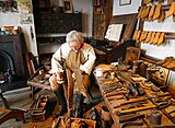 Cobbler's shop
 Re-creation of a tunnel in a lead mine
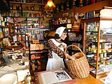 General store from the 1940s
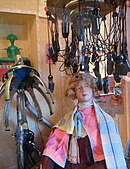 Hairdressing salon from the 1950s


