
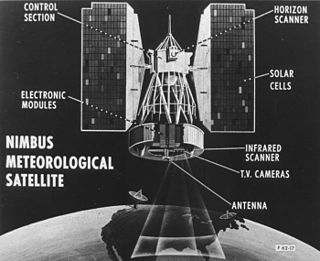
The Nimbus satellites were second-generation U.S. robotic spacecraft launched between 1964 and 1978 used for meteorological research and development. The spacecraft were designed to serve as stabilized, Earth-oriented platforms for the testing of advanced systems to sense and collect atmospheric science data. Seven Nimbus spacecraft have been launched into near-polar, Sun-synchronous orbits beginning with Nimbus 1 on August 28, 1964. On board the Nimbus satellites are various instrumentation for imaging, sounding, and other studies in different spectral regions. The Nimbus satellites were launched aboard Thor-Agena rockets and Delta rockets.

The Upper Atmosphere Research Satellite (UARS) was a NASA-operated orbital observatory whose mission was to study the Earth's atmosphere, particularly the protective ozone layer. The 5,900-kilogram (13,000 lb) satellite was deployed from Space Shuttle Discovery during the STS-48 mission on 15 September 1991. It entered Earth orbit at an operational altitude of 600 kilometers (370 mi), with an orbital inclination of 57 degrees.

NOAA-17, also known as NOAA-M before launch, was an operational, polar orbiting, weather satellite series operated by the National Environmental Satellite Service (NESS) of the National Oceanic and Atmospheric Administration (NOAA). NOAA-17 also continued the series of Advanced TIROS-N (ATN) spacecraft begun with the launch of NOAA-8 (NOAA-E) in 1983 but with additional new and improved instrumentation over the NOAA A-L series and a new launch vehicle.

NOAA-16, also known as NOAA-L before launch, was an operational, polar orbiting, weather satellite series operated by the National Environmental Satellite Service (NESS) of the National Oceanic and Atmospheric Administration (NOAA). NOAA-16 continued the series of Advanced TIROS-N (ATN) spacecraft that began with the launch of NOAA-8 (NOAA-E) in 1983; but it had additional new and improved instrumentation over the NOAA A-K series and a new launch vehicle. It was launched on 21 September 2000 and, following an unknown anomaly, it was decommissioned on 9 June 2014. In November of 2015 it broke up in orbit, creating more than 200 pieces of debris.

NOAA-15, also known as NOAA-K before launch, is an operational, polar-orbiting of the NASA-provided Television Infrared Observation Satellite (TIROS) series of weather forecasting satellite operated by National Oceanic and Atmospheric Administration (NOAA). NOAA-15 was the latest in the Advanced TIROS-N (ATN) series. It provided support to environmental monitoring by complementing the NOAA/NESS Geostationary Operational Environmental Satellite program (GOES).
NOAA-13, also known as NOAA-I before launch, was an American weather satellite operated by the National Oceanic and Atmospheric Administration (NOAA). NOAA-I continued the operational, polar orbiting, meteorological satellite series operated by the National Environmental Satellite System (NESS) of the National Oceanic and Atmospheric Administration (NOAA). NOAA-I continued the series (fifth) of Advanced TIROS-N (ATN) spacecraft begun with the launch of NOAA-8 (NOAA-E) in 1983. NOAA-I was in an afternoon equator-crossing orbit and was intended to replace the NOAA-11 (NOAA-H) as the prime afternoon (14:00) spacecraft.

The Solar Backscatter Ultraviolet Radiometer, or SBUV/2, is a series of operational remote sensors on NOAA weather satellites in Sun-synchronous orbits which have been providing global measurements of stratospheric total ozone, as well as ozone profiles, since March 1985. The SBUV/2 instruments were developed from the SBUV experiment flown on the Nimbus-7 spacecraft which improved on the design of the original BUV instrument on Nimbus-4. These are nadir viewing radiometric instruments operating at mid to near UV wavelengths. SBUV/2 data sets overlap with data from SBUV and TOMS instruments on the Nimbus-7 spacecraft. These extensive data sets measure the density and vertical distribution of ozone in the Earth's atmosphere from six to 30 miles.

ADEOS I was an Earth observation satellite launched by NASDA in 1996. The mission's Japanese name, Midori means "green". The mission ended in July 1997 after the satellite sustained structural damage to the solar panel. Its successor, ADEOS II, was launched in 2002. Like the first mission, it ended after less than a year, also following solar panel malfunctions.

The Joint Polar Satellite System (JPSS) is the latest generation of U.S. polar-orbiting, non-geosynchronous, environmental satellites. JPSS will provide the global environmental data used in numerical weather prediction models for forecasts, and scientific data used for climate monitoring. JPSS will aid in fulfilling the mission of the U.S. National Oceanic and Atmospheric Administration (NOAA), an agency of the Department of Commerce. Data and imagery obtained from the JPSS will increase timeliness and accuracy of public warnings and forecasts of climate and weather events, thus reducing the potential loss of human life and property and advancing the national economy. The JPSS is developed by the National Aeronautics and Space Administration (NASA) for the National Oceanic and Atmospheric Administration (NOAA), who is responsible for operation of JPSS. Three to five satellites are planned for the JPSS constellation of satellites. JPSS satellites will be flown, and the scientific data from JPSS will be processed, by the JPSS – Common Ground System (JPSS-CGS).

NOAA-21, designated JPSS-2 prior to launch, is the second of the United States National Oceanic and Atmospheric Administration (NOAA)'s latest generation of U.S. polar-orbiting, non-geosynchronous, environmental satellites called the Joint Polar Satellite System. NOAA-21 was launched on 10 November 2022 and join NOAA-20 and Suomi NPP in the same orbit. Circling the Earth from pole-to-pole, it will cross the equator about 14 times daily, providing full global coverage twice a day. It was launched with LOFTID.
NOAA-20, designated JPSS-1 prior to launch, is the first of the United States National Oceanic and Atmospheric Administration's latest generation of U.S. polar-orbiting, non-geosynchronous, environmental satellites called the Joint Polar Satellite System. NOAA-20 was launched on 18 November 2017 and joined the Suomi National Polar-orbiting Partnership satellite in the same orbit. NOAA-20 operates about 50 minutes behind Suomi NPP, allowing important overlap in observational coverage. Circling the Earth from pole-to-pole, it crosses the equator about 14 times daily, providing full global coverage twice a day. This gives meteorologists information on "atmospheric temperature and moisture, clouds, sea-surface temperature, ocean color, sea ice cover, volcanic ash, and fire detection" so as to enhance weather forecasting including hurricane tracking, post-hurricane recovery by detailing storm damage and mapping of power outages.

Nimbus 1 was a meteorological satellite. It was the first in a series of the Nimbus program.
Nimbus 2 was a meteorological satellite. It was the second in a series of the Nimbus program.

Nimbus 3 was a meteorological satellite. It was the third in a series of the Nimbus program.
Nimbus 4 was a meteorological satellite. It was the fourth in a series of the Nimbus program.
Nimbus 5 was a meteorological satellite for the research and development of sensing technology. It was the fifth successful launch in a series of the Nimbus program.
NOAA-5, also known as ITOS-H was a weather satellite operated by the National Oceanic and Atmospheric Administration (NOAA). It was part of a series of satellites called ITOS, or improved TIROS, being the last of the series. NOAA-5 was launched on a Delta rocket on July 29, 1976.
NOAA-10, known as NOAA-G before launch, was an American weather satellite operated by the National Oceanic and Atmospheric Administration (NOAA) for use in the National Environmental Satellite Data and Information Service (NESDIS). It was the third of the Advanced TIROS-N series of satellites. The satellite design provided an economical and stable Sun-synchronous platform for advanced operational instruments to measure the atmosphere of Earth, its surface and cloud cover, and the near-space environment.
NOAA-11, known as NOAA-H before launch, was an American weather satellite operated by the National Oceanic and Atmospheric Administration (NOAA) for use in the National Operational Environmental Satellite System (NOESS) and for support of the Global Atmospheric Research Program (GARP) during 1978–1984. It was the fourth of the Advanced TIROS-N series of satellites. The satellite design provided an economical and stable Sun-synchronous platform for advanced operational instruments to measure the atmosphere of Earth, its surface and cloud cover, and the near-space environment.
NOAA-14, also known as NOAA-J before launch, was an American weather satellite operated by the National Oceanic and Atmospheric Administration (NOAA). NOAA-14 continued the third-generation operational, Polar Orbiting Environmental Satellite (POES) series operated by the National Environmental Satellite Service (NESS) of the National Oceanic and Atmospheric Administration (NOAA). NOAA-14 continued the series of Advanced TIROS-N (ATN) spacecraft begun with the launch of NOAA-8 (NOAA-E) in 1983.
