Interstate 19 (I-19) is a north–south Interstate Highway located entirely within the U.S. state of Arizona. I-19 travels from Nogales, roughly 300 feet (91 m) from the Mexican border, to Tucson, at I-10. The highway also travels through the cities of Rio Rico, Green Valley, and Sahuarita.

Santa Cruz is a county in southern Arizona, United States. As of the 2010 census, its population is 47,420. The county seat is Nogales. The county was established in 1899. It borders Pima County to the north and west, Cochise County to the east, and the Mexican state of Sonora to the south.
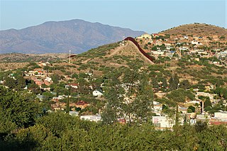
Nogales is a city in Santa Cruz County, Arizona. The population was 20,837 at the 2010 census and estimated 20,103 in 2019. Nogales forms part of the larger Tucson-Nogales combined statistical area, with a total population of 1,027,683 as of the 2010 Census. The city is the county seat of Santa Cruz County.

Heroica Nogales, more commonly known as Nogales, is a city and the county seat of the Municipality of Nogales. It is located on the northern border of the Mexican state of Sonora. The city is abutted on its north by the city of Nogales, Arizona, across the U.S.-Mexico border.

A border checkpoint is a place, generally between two countries, where travelers or goods are inspected. Authorization often is required to enter a country through its borders. Access-controlled borders often have a limited number of checkpoints where they can be crossed without legal sanctions. Arrangements or treaties may be formed to allow or mandate less restrained crossings. Land border checkpoints can be contrasted with the customs and immigration facilities at seaports, international airports, and other ports of entry.
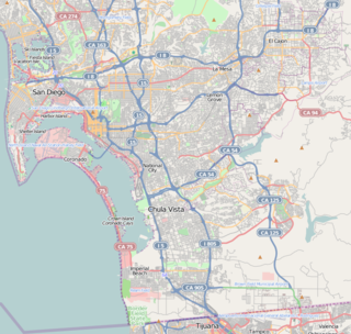
San Ysidro is a district of the City of San Diego, immediately north of the U.S.-Mexico border. It neighbors Otay Mesa West to the north, Otay Mesa to the east, and Nestor and the Tijuana River Valley to the west; together these communities form South San Diego, a practical exclave of the City of San Diego. Major thoroughfares include Beyer Boulevard and San Ysidro Boulevard.
The Progreso–Nuevo Progreso International Bridge on the U.S.–Mexico border, has been in operation at this location since 1952. It connects the cities of Progreso, Texas, and Nuevo Progreso, Tamaulipas.

Federal Highway 15 is Mexico 15 International Highway or Mexico-Nogales Highway, is a primary north-south highway, and is a free part of the federal highways corridors of Mexico. The highway begins in the north at the Mexico–United States border at the Nogales Port of Entry in Nogales, Sonora, and terminates to the south in Mexico City.

The Secure Electronic Network for Travelers Rapid Inspection (SENTRI) provides expedited U.S. Customs and Border Protection (CBP) processing, at the U.S.-Mexico border, of pre-approved travelers considered low-risk. Voluntarily applicants must undergo a thorough background check against criminal, customs, immigration, law enforcement, and terrorist databases; a 10-fingerprint law enforcement check; and a personal interview with a CBP Officer. The total enrollment fee is $122.50, and SENTRI status is valid for 5 years.

The Gateway to the Americas International Bridge is one of four vehicular international bridges located in the cities of Laredo, Texas, and Nuevo Laredo, Tamaulipas, that connect the United States and Mexico over the Rio Grande. It is owned and operated by the City of Laredo and the Secretaría de Comunicaciones y Transportes. It is also known as Laredo International Bridge 1.

Antelope Wells is a small unincorporated community in Hidalgo County, New Mexico, United States. The community is located along the Mexico-United States border, in the New Mexico Bootheel region, located across the border from the small settlement of El Berrendo, Chihuahua, Mexico. Despite its name, there are neither antelope nor wells in the area. The name comes from an old ranch, located 2.5 miles (4.0 km) north of the current community. The only inhabitants of the community are U.S. Customs and Border Protection employees.

The San Ysidro Port of Entry is the largest land border crossing between San Diego and Tijuana, and the fourth-busiest land border crossing in the world with 70,000 northbound vehicles and 20,000 northbound pedestrians crossing each day, in addition to southbound traffic. It connects Mexican Federal Highway 1 on the Mexican side with Interstate 5 on the American side. The San Ysidro Port of Entry is one of three ports of entry in the San Diego–Tijuana metropolitan region.
The Otay Mesa Port of Entry is one of three ports of entry (POE) in the San Diego–Tijuana metropolitan region, in the U.S. state of California, connecting Otay Mesa in the City of San Diego with the Otay Centenario borough of Tijuana. The facility was opened in 1983, and was constructed primarily to divert growing commercial truck traffic from the busy San Ysidro Port of Entry. Since then, significant passenger vehicle and pedestrian traffic has grown as development in the area around the crossing has grown. Commercial importations through Otay Mesa accounts for billions of dollars' worth of freight.

The Tecate Port of Entry is one three ports of entry in the San Diego–Tijuana metropolitan region. The land port is located between Tecate, California in San Diego County's Mountain Empire and Tecate Municipality in Baja California. It connects California State Route 188 with Paseo Lazero Cardenas, a spur of Mexico Federal Highway 2, as well as Federal Highway 3 to the south. It is a minor port in comparison to the larger San Ysidro Port of Entry and Otay Mesa Port of Entry. This is attributed in part to the fact that reaching the crossing on the US side requires driving on narrow, winding mountain roads.

The Calexico East Port of Entry is a border crossing point between the United States and Mexico. It connects the cities of Calexico, California and Mexicali, Baja California. It connects directly to California State Route 7.

The Nogales-Mariposa Arizona Port of Entry opened in 1973 to divert truck traffic away from the busy downtown Grand Avenue border crossing. It connects Arizona State Route 189 directly with Mexican Federal Highway 15D. All commercial traffic entering the United States at Nogales now enters through the Mariposa port of entry. The port facilities are currently undergoing substantial renovation to accommodate increasing traffic and to support new equipment and procedures.

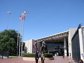
The Nogales Arizona Port of Entry on Grand Avenue has been in existence since the early 20th century. It connects Interstate 19 with Mexican Federal Highway 15. The port of entry is named after former Arizona Senator Dennis DeConcini. The border station was completely rebuilt in 1966 and upgrades to the pedestrian gates were made by the General Services Administration in 2012. It is one of three border crossings in Nogales; the Nogales-Mariposa Port of Entry, built in 1973, handles commercial traffic west of the Grand Avenue crossing, while the adjacent Nogales-Morley Gate Port of Entry is used for pedestrians.

The El Paso Paso del Norte (PDN) Port of Entry, is among the United States' busiest border crossings. More than 10 million people enter the US from Mexico each year at this location. Upon arrival, the admissibility of each person is determined by an officer of Customs and Border Protection (CBP). Frequently the vehicle and/or possessions of those entering the US are inspected by CBP in an effort to prevent contraband from being brought into the US.

The Laredo Convent Avenue Port of Entry is located at the Gateway to the Americas International Bridge. Since 1889, a bridge connected Laredo, Texas with Nuevo Laredo, Tamaulipas at this location. For many years, this was the only crossing for vehicular and pedestrian traffic between the two cities.


