Normandie Heights, Pasadena, California

Last updated

Normandie Heights is a neighborhood in Pasadena, California. It is bordered by Woodbury Road to the north, Washington Boulevard to the south, Los Robles Avenue to the west, and Lake Avenue to the east. While the exterior of many older homes in Southern California have been coated with stucco, Normandie is distinguished by a high concentration of Craftsman homes with well-maintained wooden exteriors. Accordingly, the City of Pasadena has designated more than 50 homes in the neighborhood as architectural landmarks, many on Rio Grande Street, between Los Robles Avenue and El Molino Avenue, which was the site of the first residences in the neighborhood. [1]

Contents

Though largely obscured by trees, the street of Palm Terrace in the Normandie Heights neighborhood of Pasadena, California features a number of immaculately-maintained Craftsman homes. Palm Terrace, Pasadena, CA.jpg
Though largely obscured by trees, the street of Palm Terrace in the Normandie Heights neighborhood of Pasadena, California features a number of immaculately-maintained Craftsman homes.

A significant number of motion pictures and television shows have been shot in Normandie Heights, including parts of the films Valkyrie, Old School, Wedding Crashers, The War of the Worlds, and The Wedding Planner. [2] [3]

Landmarks

Normandie's most prominent landmark is the clock tower at Westminster Presbyterian Church. [4]

Westminster Presbyterian Church, visible for over a mile, this Gothic-style church is located on the west side of Lake Avenue, between Atchison Street and Woodbury Road in Pasadena. 018-01-02-Westminster.jpg
Westminster Presbyterian Church, visible for over a mile, this Gothic-style church is located on the west side of Lake Avenue, between Atchison Street and Woodbury Road in Pasadena.

St. Elizabeth of Hungary Catholic Church is associated with Normandie Heights, but is located on the northern side of Woodbury Road, just outside the neighborhood boundaries. [5]

St. Elizabeth of Hungary Church, located on the west side of Lake Avenue between Woodbury Road and New York Drive, this church lies just outside the boundary of the Normandie Heights neighborhood of Pasadena. 2018-01-02-St Elizabeth.jpg
St. Elizabeth of Hungary Church, located on the west side of Lake Avenue between Woodbury Road and New York Drive, this church lies just outside the boundary of the Normandie Heights neighborhood of Pasadena.

The Seth Cook Rees House, designed by Francis W. Wilson for the pastor and evangelist Seth Cook Rees (1854-1933), is also located in the neighborhood. The home, located at the southeast corner of Elizabeth Street and El Molino Avenue, has been designated as an historical landmark by the City of Pasadena, and serves as a prime example of Arts and Crafts period residential architecture. [6]

Seth Cook Rees House, a landmark designed by architect Francis W. Wilson and built in 1908. Seth Cook Rees House.jpg
Seth Cook Rees House, a landmark designed by architect Francis W. Wilson and built in 1908.

The Normandie Heights Estate, designed by Pasadena architect Sylvanus Marston in the Colonial Revival style and built in 1911, was named for the community. The estate and its gardens were featured as a showpiece of Pasadena in the 1913 Tournament of Roses Pictorial. [7]

A collection of bungalows known as Washington Court, built in 1924 and located on the southwest edge of the neighborhood, has also been listed on the National Register of Historic Places as an exemplar of the English Cottage Revival style. [8]

Facade of Voorhees Craftsman Antiques, Lake Avenue. 018-01-02-Vorhees Facade.jpg
Facade of Voorhees Craftsman Antiques, Lake Avenue.

Pasadena's beloved Washington Theater, currently undergoing rehabilitation, is located at the southeastern edge of the neighborhood. [9] [10] [11] The theater, which enjoys historical landmark designation, was completed in 1924 and designed by the architect Clarence L. Jay in the Spanish Colonial Revival style. The theater was substantially remodeled on the exterior in 1937 in the Streamline Moderne style. The theater's rehabilitation envisions removal of the 1937 marquee, and restoration of the original 1924 marquee. [12]

Education

Normandie Heights is served by Longfellow and Altadena Elementary Schools, Eliot Middle School, and Muir and Pasadena High Schools. St. Elizabeth Parish School draws many children from the Normandie Heights neighborhood. [13]

The neighborhood is equidistant between the California Institute of Technology campus and Caltech/NASA's Jet Propulsion Laboratory.

Transportation

Normandie Heights was once served by the Mount Lowe Railway, which terminated at Lake Avenue and Calaveras Street, [14] as well as the North Lake and East Washington lines of the Red Car trolley system. [15]

Normandie Heights is currently served by Metro Local lines 256 and 662. [16] The neighborhood is also served by Pasadena ARTS routes 20, 31, and 32. [17]

Government

Normandie Heights is split between Pasadena City Council District 1, represented by Tyron Hampton, District 3, represented by John J. Kennedy, and District 5, represented by Jessica Rivas. [18]

Notable residents

Related Research Articles

Pasadena, California City in Los Angeles County, California

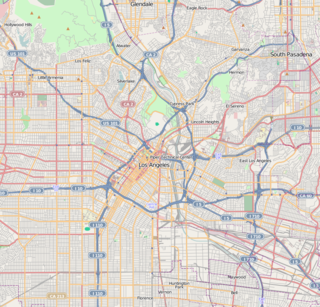
Pasadena is a city in Los Angeles County, California, 11 miles (18 km) northeast of downtown Los Angeles. It is the most populous city and the primary cultural center of the San Gabriel Valley. With its substantial downtown area, observers consider it as either a suburb of nearby Los Angeles, or as a significant urban center in its own right.

Altadena, California Census-designated place in California, United States

Altadena is an unincorporated area and census-designated place in the Verdugo Mountains region of Los Angeles County, California, approximately 14 miles (23 km) from the downtown Los Angeles Civic Center, and directly north of the city of Pasadena, California. The population was 42,777 at the 2010 census, up from 42,610 at the 2000 census.

Washington Heights, Manhattan Neighborhood of Manhattan in New York City

Washington Heights is a neighborhood in the uppermost part of the New York City borough of Manhattan. It is named for Fort Washington, a fortification constructed at the highest natural point on Manhattan Island by Continental Army troops to defend the area from the British forces during the American Revolutionary War. Washington Heights is bordered by Inwood to the north along Dyckman Street, by Harlem to the south along 155th Street, by the Harlem River and Coogan's Bluff to the east, and by the Hudson River to the west.

Lincoln Heights, Los Angeles Neighborhood of Los Angeles in California, United States

Lincoln Heights is one of the oldest neighborhoods in Los Angeles, California. It is a densely populated, youthful area that has a high percentage of Latino, Asian, and Pacific Islander residents. It includes several historic or notable landmarks.

Pico-Union, Los Angeles Neighborhood of Los Angeles in California, United States of America

Pico-Union is a neighborhood in Central Los Angeles, California. The name "Pico-Union" refers to the neighborhood that surrounds the intersection of Pico Boulevard and Union Avenue. Located immediately west of Downtown Los Angeles, it is home to over 40,000 residents.

Hastings Ranch, Pasadena, California

Hastings Ranch is a neighborhood of Pasadena, California which lies in northeast Pasadena. It is principally accessed by Sierra Madre Boulevard, Michillinda Avenue, Hastings Ranch Blvd., and Riviera Drive. Hastings Ranch is also identified by large shopping areas at its southernmost end and by a shopping center at the corner of Sierra Madre and Michillinda. Hastings Ranch is divided by Sierra Madre Blvd, north of the blvd is Upper Hastings Ranch and south is Lower Hastings Ranch. To the north of the Ranch is the San Gabriel Mountains and Mount Wilson.

El Sereno, Los Angeles Neighborhood of Los Angeles in California, United States

El Sereno is a Los Angeles neighborhood in the Eastside Los Angeles region of Los Angeles County, California.

Foothill Boulevard is a major road in the city and county of Los Angeles, as well as an arterial road in the city and county of San Bernardino, stretching well over 60 miles (97 km) in length, with some notable breaks along the route. Like its name implies, Foothill Boulevard runs across the foothills of the San Gabriel and San Bernardino Mountains.

Fair Oaks Avenue (Pasadena, California) Road in Pasadena, California, United States

Fair Oaks Avenue in Pasadena, California, is a major north–south road connecting the communities of Altadena, Pasadena, and South Pasadena, running 7.9 miles (12.7 km) in length. It starts at its southernmost end in South Pasadena at Huntington Drive. It travels due north to a terminus above Loma Alta Avenue in Altadena and the gates of Angelus County Park. Beyond this, the road becomes a private easement.

Christmas Tree Lane United States historic place

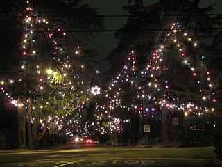
Christmas Tree Lane is a 0.7-mile (1.1 km) boulevard of deodar cedar trees in Altadena, California. The trees on the Lane, Santa Rosa Avenue, have been lighted annually as a Christmas Holiday display since 1920. The association that runs it claims it is "the oldest large-scale outdoor Christmas display in the world". Christmas Tree Lane was listed on the U.S. National Register of Historic Places in 1990, the same year it was also designated as California Historical Landmark No. 990.

Edwin Wallace Neff was an architect based in Southern California and was largely responsible for developing the region's distinct architectural style referred to as "California" style. Neff was a student of architect Ralph Adams Cram and drew heavily from the architectural styles of both Spain and the Mediterranean as a whole, gaining extensive recognition from the number of celebrity commissions, notably Pickfair, the mansion belonging originally to Mary Pickford and Douglas Fairbanks.

Myron Hunt American architect

Myron Hubbard Hunt was an American architect whose numerous projects include many noted landmarks in Southern California and Evanston, Illinois. Hunt was elected a Fellow in the American Institute of Architects in 1908.

Banbury Oaks is a neighborhood in Pasadena, California. It is bordered by Washington Boulevard to the north, Mountain Street to the south, Fair Oaks Avenue to the East, and Forest Avenue to the west. The neighborhood is bisected by I-210. The main roads through the neighborhood are Hammond Street and Lincoln Avenue.

Garfield Heights is a neighborhood in Pasadena, California. The original tract name registered with the city of Pasadena in 1904. In 1998, the area was designated a landmark district. It is bordered by Washington Boulevard to the north, Mountain Street to the south, North Marengo Avenue to the west, and Los Robles Avenue to the east.

Olive Heights is the most densely populated neighborhood in Pasadena, California.It is bordered by Mountain Street to the north, Walnut Street to the south, El Molino Avenue to the west, and Lake Avenue to the east.

Playhouse District, Pasadena, California Neighborhood in Pasadena, California, United States

Playhouse Village, a neighborhood in Pasadena, California, is bordered by Interstate 210 to the north, California Boulevard to the south, Los Robles Avenue to the west, and Hudson Avenue to the east, with a panhandle-like extension to Wilson Avenue. The district is also notable for its manhattanization, the legacy of extensive urbanization from the 1960s to the 1980s.

Washington Square is a neighborhood in Pasadena, California. It is bordered by Washington Boulevard to the north, Mountain Street to the south, El Molino Avenue to the west, and Lake Avenue to the east. It is notable for having been renamed several times, having been known as part of Orange Heights until the 1950s, then Clement Heights until the 1980s when it was shortened to CLEM, then Heather Heights until the late 1990s when it was given its current name. The neighborhood was built up gradually until the 1940s, when the last housing tract was built around Heather Square.

History of Pasadena, California

Pasadena is a city in Los Angeles County, California, United States. Famous for its colourful history and the hosting of the Tournament of Roses Parade since 1890, and the annual Rose Bowl football game since 1902. Pasadena was founded in 1874 and incorporated in 1886.

Sidewalk clock on Jamaica Avenue United States historic place

The sidewalk clock on Jamaica Avenue is an early-20th-century sidewalk clock at the southwest corner of Jamaica Avenue and Union Hall Street in Jamaica, Queens, New York City. The cast iron clock's design incorporates a bell-cast shaped column base and an anthemion finial above the dial casing. The clock has become a famous landmark of Jamaica Avenue in New York City, New York.

Seth Cook Rees

Seth Cook Rees was a leading figure in the “holiness movement," co-founding the International Holiness Union and Prayer League, and, following a schism with the Church of the Nazarene, founding the Pilgrim Holiness Church, a forerunner of the Wesleyan Church.

References

  1. "California Historical Resources Inventory Database, City of Pasadena". 2018-01-07. Retrieved 2018-01-07.
  2. "IMDb: Most Popular Titles With Location Matching "Westminster Presbyterian Church - 1757 North Lake Avenue, Pasadena, California, USA"". IMDb. Retrieved 2018-01-08.
  3. "Parking & Filming | Westminster Presbyterian Church | We Are A Living Church". wpcpas.org. Retrieved 2018-01-08.
  4. "Westminster Presbyterian Church | We Are A Living Church". wpcpas.org. Retrieved 2018-01-02.
  5. "Welcome to St. Elizabeth Catholic Church". saintelizabethchurch.org. Retrieved 2018-01-02.
  6. "California Historical Resources Inventory Database". pasadena.cfwebtools.com. Retrieved 2018-01-02.
  7. Dtrader (2009-03-03). "Normandie Heights, Pasadena, California: Normandie Heights Historical Background". Normandie Heights, Pasadena, California. Retrieved 2018-01-08.
  8. "California Historical Resources Inventory Database". pasadena.cfwebtools.com. Retrieved 2018-01-08.
  9. "Friends of The Washington Theater". www.facebook.com. Retrieved 2018-01-07.
  10. "Restoration of Pasadena's historic Cinema 21 is nearly done, but it may never be used as a theater". Pasadena Star News. 2017-10-29. Retrieved 2018-01-08.
  11. "Field Trip - Washington Theater". www.fieldtripper.com. Retrieved 2018-01-08.
  12. "City of Pasadena Planning & Community Development, Staff Report re 851 East Washington Boulevard (Washington Theater-- Designated Landmark) Certificate of Appropriateness- Restoration of Original 1924 Theater Marquee" (PDF). 2017-09-19. Retrieved 2018-01-07.
  13. "Home Page - Saint Elizabeth Parish School in Altadena". www.saint-elizabeth.org. Retrieved 2018-01-02.
  14. "Water and Power Associates". waterandpower.org. Retrieved 2018-01-08.
  15. "Mapping the Historic Routes and Few Remains of Los Angeles's Massive Streetcar System". Curbed LA. Retrieved 2018-01-08.
  16. "Maps & Timetables". www.metro.net. Retrieved 2018-01-08.
  17. Pasadena, City of. "Pasadena Transit". ww5.cityofpasadena.net. Retrieved 2018-01-08.
  18. "Map of Pasadena City Council Districts" (PDF).

Coordinates: 34°10′17″N118°07′56″W / 34.171415°N 118.132132°W / 34.171415; -118.132132