
Greenland is a North American autonomous territory of the Kingdom of Denmark. It is the larger of two autonomous territories within the Kingdom, the other being the Faroe Islands; the citizens of both territories are full citizens of Denmark. As Greenland is one of the Overseas Countries and Territories of the European Union, citizens of Greenland are European Union citizens. The capital and largest city of Greenland is Nuuk. Greenland lies between the Arctic and Atlantic oceans, east of the Canadian Arctic Archipelago. It is the world's largest island, and is the location of the northernmost area of the world – Kaffeklubben Island off the northern coast is the world's northernmost undisputed point of land, and Cape Morris Jesup on the mainland was thought to be so until the 1960s.

Greenland is located between the Arctic Ocean and the North Atlantic Ocean, northeast of Canada and northwest of Iceland. The territory comprises the island of Greenland—the largest island in the world—and more than a hundred other smaller islands. Greenland has a 1.2-kilometer-long (0.75 mi) border with Canada on Hans Island. A sparse population is confined to small settlements along certain sectors of the coast. Greenland possesses the world's second-largest ice sheet.

The Northwest Passage (NWP) is the sea lane between the Atlantic and Pacific oceans through the Arctic Ocean, along the northern coast of North America via waterways through the Arctic Archipelago of Canada. The eastern route along the Arctic coasts of Norway and Siberia is accordingly called the Northeast Passage (NEP). The various islands of the archipelago are separated from one another and from Mainland Canada by a series of Arctic waterways collectively known as the Northwest Passages, Northwestern Passages or the Canadian Internal Waters.

The North Pole, also known as the Geographic North Pole, Terrestrial North Pole or 90th Parallel North, is the point in the Northern Hemisphere where the Earth's axis of rotation meets its surface. It is called the True North Pole to distinguish from the Magnetic North Pole.

The Arctic is a polar region located at the northernmost part of Earth. The Arctic region, from the IERS Reference Meridian travelling east, consists of parts of northern Norway, northernmost Sweden, northern Finland, Russia, the United States (Alaska), Canada, Danish Realm (Greenland), and northern Iceland, along with the Arctic Ocean and adjacent seas. Land within the Arctic region has seasonally varying snow and ice cover, with predominantly treeless permafrost under the tundra. Arctic seas contain seasonal sea ice in many places.

Ellesmere Island is Canada's northernmost and third largest island, and the tenth largest in the world. It comprises an area of 196,236 km2 (75,767 sq mi), slightly smaller than Great Britain, and the total length of the island is 830 km (520 mi).

Ilulissat, formerly Jakobshavn or Jacobshaven, is the municipal seat and largest town of the Avannaata municipality in western Greenland, located approximately 350 km (220 mi) north of the Arctic Circle. With a population of 4,670 as of 2020, it is the third-largest city in Greenland, after Nuuk and Sisimiut. The city is home to almost as many sled-dogs as people.

Baffin Bay, located between Baffin Island and the west coast of Greenland, is defined by the International Hydrographic Organization as a marginal sea of the Arctic Ocean. It is sometimes considered a sea of the North Atlantic Ocean. It is connected to the Atlantic via Davis Strait and the Labrador Sea. The narrower Nares Strait connects Baffin Bay with the Arctic Ocean. The bay is not navigable most of the year because of the ice cover and high density of floating ice and icebergs in the open areas. However, a polynya of about 80,000 km2 (31,000 sq mi), known as the North Water, opens in summer on the north near Smith Sound. Most of the aquatic life of the bay is concentrated near that region.
Oodaaq or Oodap Qeqertaa is a bank of gravel and silt northeast of Greenland that has been considered by some to be the northernmost point of land on Earth, though a number of other places have also been given that title since its discovery. It may have been created by the impact of an iceberg in a shallow sea. However, the area of ice in which it appears does not move from year to year. If it was created by an iceberg, then it must have happened long ago.

Kaffeklubben Island or Coffee Club Island is an uninhabited island lying off the northern shore of Greenland. It contains the northernmost undisputed point of land on Earth.

A polar ice cap or polar cap is a high-latitude region of a planet, dwarf planet, or natural satellite that is covered in ice.

Dennis Schmitt is an American veteran explorer, adventurer and composer.

The Greenland Sea is a body of water that borders Greenland to the west, the Svalbard archipelago to the east, Fram Strait and the Arctic Ocean to the north, and the Norwegian Sea and Iceland to the south. The Greenland Sea is often defined as part of the Arctic Ocean, sometimes as part of the Atlantic Ocean. However, definitions of the Arctic Ocean and its seas tend to be imprecise or arbitrary. In general usage the term "Arctic Ocean" would exclude the Greenland Sea. In oceanographic studies the Greenland Sea is considered part of the Nordic Seas, along with the Norwegian Sea. The Nordic Seas are the main connection between the Arctic and Atlantic oceans and, as such, could be of great significance in a possible shutdown of thermohaline circulation. In oceanography the Arctic Ocean and Nordic Seas are often referred to collectively as the "Arctic Mediterranean Sea", a marginal sea of the Atlantic.

Lincoln Sea is a body of water in the Arctic Ocean, stretching from Cape Columbia, Canada, in the west to Cape Morris Jesup, Greenland, in the east. The northern limit is defined as the great circle line between those two headlands. It is covered with sea ice throughout the year, the thickest sea ice in the Arctic Ocean, which can be up to 15 m (49 ft) thick. Water depths range from 100 m (330 ft) to 300 m (980 ft). Water and ice from Lincoln Sea empty into Robeson Channel, the northernmost part of Nares Strait, most of the time.
The Arctic consists of land, internal waters, territorial seas, exclusive economic zones (EEZs) and international waters above the Arctic Circle. All land, internal waters, territorial seas and EEZs in the Arctic are under the jurisdiction of one of the eight Arctic coastal states: Canada, Denmark, Finland, Iceland, Norway, Russia, Sweden and the United States. International law regulates this area as with other portions of Earth.

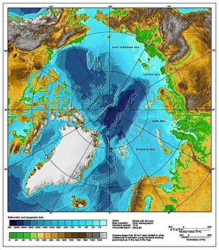
The Arctic Ocean is the smallest and shallowest of the world's five oceanic divisions. It spans an area of approximately 14,060,000 km2 (5,430,000 sq mi) and is known as one of the coldest of oceans. The International Hydrographic Organization (IHO) recognizes it as an ocean, although some oceanographers call it the Arctic Mediterranean Sea. It has also been described as an estuary of the Atlantic Ocean. It is also seen as the northernmost part of the all-encompassing world ocean.
83-42 was a rocky ice floe in the Arctic Ocean. It is also sometimes referred to as Eklipse 0, or Schmitt’s Island, after its discoverer, Dennis Schmitt. It measures 35 by 15 metres and 4 metres (13 ft) in height, and lies 699.8 kilometres (434.8 mi) from the North Pole. When it was discovered in 2003, lichens were found growing on it, suggesting it was not one of the temporary gravel bars commonly found in that region.
Stray Dog West is an island in Greenland. It is a candidate for the northernmost island on Earth.
Qeqertaq Avannarleq is an unofficial name of what was thought to be a previously uncharted island in the Arctic Ocean, discovered in August 2021. It is off of the northern tip of Greenland, and consists primarily of seabed mud and moraine, an accumulation of unconsolidated debris left behind by glaciers. One theory as to its creation was that it was formed relatively recently, during a violent storm.
