Jan Mayen is a Norwegian volcanic island in the Arctic Ocean with no permanent population. It is 55 km (34 mi) long (southwest-northeast) and 373 km2 (144 sq mi) in area, partly covered by glaciers. It has two parts: larger northeast Nord-Jan and smaller Sør-Jan, linked by a 2.5 km (1.6 mi) wide isthmus. It lies 600 km (370 mi) northeast of Iceland, 500 km (310 mi) east of central Greenland, and 900 km (560 mi) northwest of Vesterålen, Norway. The island is mountainous, the highest summit being the Beerenberg volcano in the north. The isthmus is the location of the two largest lakes of the island, Sørlaguna and Nordlaguna. A third lake is called Ullerenglaguna. Jan Mayen was formed by the Jan Mayen hotspot and is defined by geologists as a microcontinent.

Bear Island is the southernmost island of the Norwegian Svalbard archipelago. The island is located at the limits of the Norwegian and Barents Seas, approximately halfway between Spitsbergen and the North Cape. Bear Island was discovered by Dutch explorers Willem Barentsz and Jacob van Heemskerck on 10 June 1596. It was named after a polar bear that was seen swimming nearby. The island was considered terra nullius until the Spitsbergen Treaty of 1920 placed it under Norwegian sovereignty.

Svalbard and Jan Mayen is a statistical designation defined by ISO 3166-1 for a collective grouping of two remote jurisdictions of Norway: Svalbard and Jan Mayen. While the two are combined for the purposes of the International Organization for Standardization (ISO) category, they are not administratively related. This has further resulted in the country code top-level domain .sj being issued for Svalbard and Jan Mayen, and ISO 3166-2:SJ. The United Nations Statistics Division also uses this code, but has named it the Svalbard and Jan Mayen Islands.

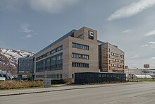
Ny-Ålesund is a small town in Oscar II Land on the island of Spitsbergen in Svalbard, Norway. It is situated on the Brøgger peninsula (Brøggerhalvøya) and on the shore of the bay of Kongsfjorden. The company town is owned and operated by Kings Bay, which provides facilities for permanent research activities by 19 institutions from 11 countries. The town is ultimately owned by the Ministry of Climate and Environment and is not incorporated. Ny-Ålesund has an all-year permanent population of 30 to 35, with the summer population reaching 114. Its facilities include Ny-Ålesund Airport, Hamnerabben, Svalbard Rocket Range, a port and Ny-Ålesund Town and Mine Museum, as well as a number of buildings dedicated to research and environmental monitoring activities. It is the northernmost functional civilian settlement in the world.
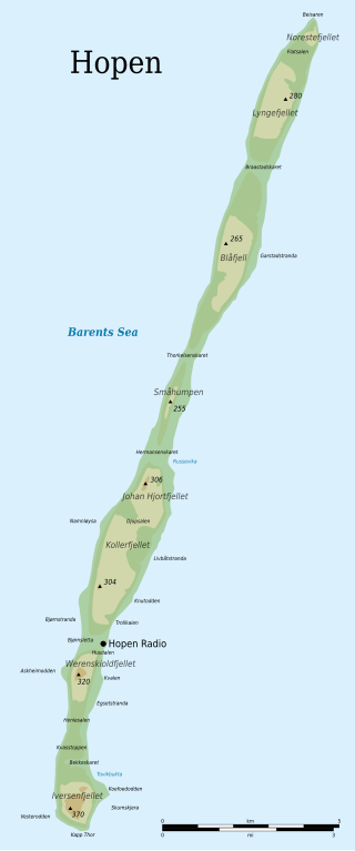
Hopen is an island in the southeastern part of the Svalbard archipelago (Norway). Hopen was discovered in 1596 by Jan Cornelisz Rijp during the third expedition by Willem Barentsz, trying to find the Northeast Passage. Later, in 1613, its name was given by Thomas Marmaduke of Hull, who named it after his former command, the Hopewell.

The Greenland Sea is a body of water that borders Greenland to the west, the Svalbard archipelago to the east, Fram Strait and the Arctic Ocean to the north, and the Norwegian Sea and Iceland to the south. The Greenland Sea is often defined as part of the Arctic Ocean, sometimes as part of the Atlantic Ocean. However, definitions of the Arctic Ocean and its seas tend to be imprecise or arbitrary. In general usage the term "Arctic Ocean" would exclude the Greenland Sea. In oceanographic studies the Greenland Sea is considered part of the Nordic Seas, along with the Norwegian Sea. The Nordic Seas are the main connection between the Arctic and Atlantic oceans and, as such, could be of great significance in a possible shutdown of thermohaline circulation. In oceanography the Arctic Ocean and Nordic Seas are often referred to collectively as the "Arctic Mediterranean Sea", a marginal sea of the Atlantic.

Adolf Hoel was a Norwegian geologist, environmentalist and Polar region researcher. He led several scientific expeditions to Svalbard and Greenland. Hoel has been described as one of the most iconic and influential figures in Norwegian polar exploration in the first half of the 20th century, alongside Fridtjof Nansen and Roald Amundsen. His focus on and research of the polar areas has been largely credited as the reason Norway has sovereignty over Svalbard and Queen Maud Land in the Antarctica.

The Fram Strait is the passage between Greenland and Svalbard, located roughly between 77°N and 81°N latitudes and centered on the prime meridian. The Greenland and Norwegian Seas lie south of Fram Strait, while the Nansen Basin of the Arctic Ocean lies to the north. Fram Strait is noted for being the only deep connection between the Arctic Ocean and the World Oceans. The dominant oceanographic features of the region are the West Spitsbergen Current on the east side of the strait and the East Greenland Current on the west.

Queen Maud Land is a roughly 2.7-million-square-kilometre (1.0-million-square-mile) region of Antarctica claimed by Norway as a dependent territory. It borders the claimed British Antarctic Territory 20° west and the Australian Antarctic Territory 45° east. In addition, a small unclaimed area from 1939 was annexed in June 2015. Positioned in East Antarctica, it makes out about one-fifth of the continent, and is named after the Norwegian queen Maud of Wales (1869–1938).

Norway has three dependent territories, all uninhabited and located in the Southern Hemisphere. Bouvet Island (Bouvetøya) is a sub-Antarctic island in the South Atlantic Ocean. Queen Maud Land is the sector of Antarctica between the 20th meridian west and the 45th meridian east. Peter I Island is a volcanic island located 450 kilometres (280 mi) off the coast of Ellsworth Land of continental Antarctica. Despite being unincorporated areas, neither Svalbard nor Jan Mayen is formally considered a dependency. While the Svalbard Treaty regulates some aspects of that Arctic territory, it acknowledges that the islands are part of Norway. Similarly, Jan Mayen is recognized as an integral part of Norway.

ISO 3166-2:SJ is the entry for Svalbard and Jan Mayen in ISO 3166-2, part of the ISO 3166 standard published by the International Organization for Standardization (ISO). The standard defines codes for names of principal subdivisions of all countries coded in ISO 3166-1. Svalbard and Jan Mayen does not exist as an administrative region, but rather consists of two separate parts of Norway under separate jurisdictions—Svalbard and Jan Mayen. Further subdivision for Svalbard and Jan Mayen occurs under Norway's entry, ISO 3166-2:NO, namely NO-21 for Svalbard and NO-22 for Jan Mayen. There are currently no ISO 3166-2 codes for Svalbard and Jan Mayen.

Antarctic was a Swedish steamship built in Drammen, Norway, in 1871. She was used on several research expeditions to the Arctic region and to Antarctica from 1898 to 1903. In 1895 the first confirmed landing on the mainland of Antarctica was made from this ship.
Oceanwide Expeditions is a Dutch company specializing in expedition-style voyages to Antarctica and the Arctic. Deploying its own fleet of ice-strengthened vessels, Oceanwide emphasizes small-scale, flexible tours that provide passengers close contact with polar wildlife, landscapes, and historical sites. Tours usually take place in regions only accessible by sea, with little to no infrastructure. The locations visited are first reached by ship, after which expedition guides take small groups of passengers to landing sites by way of Zodiac Milpro RIBs, enabling safe cruising and maximum shore time.
Jan-Gunnar Winther is Pro-rector for research and development at UiT The Arctic University of Norway and Specialist Director at the Norwegian Polar Institute located in Tromsø. He served as Director of the Centre for the Ocean and the Arctic from 2018-2023, first affiliated with Nofima later at UiT.

Fridtjof Nansen Land was a suggested but not officially adopted Norwegian name of a territory on the southern East Coast of Greenland, that was proclaimed by Norway on July 12, 1932, and occupied until April 5, 1933. It was named after Norwegian polar explorer Fridtjof Nansen. The short-lived territory occupied much of King Frederick VI Coast, which had been claimed a century before by the Danish crown.
Arctic Trading Co. was a Norwegian company founded on 24 June 1929.

Hallvard Ophuus Devold was a Norwegian Arctic explorer, trapper and meteorologist. He was instrumental in the attempt to establish Eric the Red's Land in 1931. His brother Finn Devold (1902–1977) shared his vision and helped to establish a Norwegian station at Finnsbu, SE Greenland.

Finn Devold was a Norwegian Arctic explorer, marine biologist and meteorologist. His father was parish priest Harald Ophus Devold. Together with his brother Hallvard Devold, Finn shared an interest in the Arctic areas and in the expansion of Norwegian sovereignty across Greenland.