Nuzi (or Nuzu; AkkadianGasur; modern Yorghan Tepe, Iraq) was an ancient Mesopotamian city southwest of the city of Arrapha (modern Kirkuk), located near the Tigris river. The site consists of one medium-sized multiperiod tell and two small single period mounds.[clarification needed]
The site showed occupation as far back as the late Uruk period. The city, then named Gasur, was founded in the third millennium during the time of the Akkadian Empire. One governor under the Akkadian Empire is known from a clay sealing reading "Itbe-labba, govern[or] of Gasur".[1] In the middle of the second millennium the Hurrians gained control of the town and renamed it Nuzi. The history of the site during the intervening period is unclear, though the presence of a few cuneiform tablets from Assyria indicates that trade with nearby Assur was taking place.
After the fall of the Hurrian kingdom of Mitanni Nuzi went into gradual decline. Note that while the Hurrian period is well known from full excavation of those strata, the earlier history is not as reliable because of less substantive digging.[2] The history of Nuzi is closely interrelated with that of the nearby towns of Eshnunna and Khafajah.
Archaeology
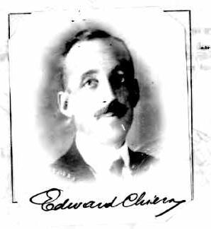
While tablets from Yorghan Tepe began appearing back as far as 1896, the first serious archaeological efforts began in 1925 after Gertrude Bell noticed tablets appearing in the markets of Baghdad. The dig was mainly worked by Edward Chiera, Robert Pfeiffer, and Richard Starr under the auspices of the Iraq Museum and the Baghdad School of the American Schools of Oriental Research and later the Harvard University and Fogg Art Museum.[3][4][5][6][7][8][9][10][11] Excavations continued through 1931 with the site showing 15 occupation levels. The hundreds of tablets and other finds recovered were published in a series of volumes[12][13] with ongoing publications.[14]
To date, around 5,000 tablets are known, mostly held at the Oriental Institute, the Harvard Semitic Museum and the Iraq Museum in Baghdad. Many are routine legal and business documents with about one quarter concerning the business transactions of a single family.[15] The vast majority of finds come from the Hurrian period during the second millennium BC with the remainder dating back to the town's founding during the Akkadian Empire. An archive contemporary with the Hurrian archive at Nuzi has been excavated from the "Green Palace" at the site of Tell al-Fakhar, 35 kilometres (22mi) southwest of Nuzi.[16]
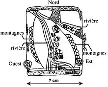
Sketch of the Nuzi map with French legends.
Perhaps the most famous item found is the Nuzi map, the oldest known map discovered. Although the majority of the tablet is preserved, it is unknown exactly what the Nuzi map shows. The Nuzi map is actually one of the so-called Gasur texts, and predates the invasion of the city of Gasur by the Hurrians, who renamed it Nuzi. The cache of economic and business documents among which the map was found date to the Old Akkadian period (ca. 2360–2180 BC).[17] Gasur was a thriving commercial center, and the texts reveal a diverse business community with far-reaching commercial activities. It is possible that Ebla was a trading partner, and that the tablet, rather than a record of land-holdings, might indeed be a road map.[17] The tablet, which is approximately 6 × 6.5cm., is inscribed only on the obverse. It shows the city of Maskan-dur-ebla in the lower left corner, as well as a canal/river and two mountain ranges.[17]
Nuzi ware
In 1948, archaeologist Max Mallowan called attention to the unusual pottery he found at Nuzi, associated with the Mitanni period. This became known as the Nuzi ware. Subsequently, this highly artistic pottery was identified all over in the Upper Mesopotamia.[18]
Nuzi, a provincial town in the 14th century BC
The best-known period in the history of Yorghan Tepe is by far one of the city of Nuzi in the 15th-14th centuries BC. The tablets of this period indicate that Nuzi was a small provincial town of northern Mesopotamia at this time in an area populated mostly by Assyrians and Hurrians, the latter a people well known though poorly documented, and that would be even less if not for the information uncovered at this site.
Administration
Nuzi was a provincial town of Arrapha. It was administered by a governor (šaknu) from the palace. The palace, situated in the center of the mound, had many rooms arranged around a central courtyard. The functions of some of those rooms have been identified: reception areas, apartments, offices, kitchens, stores. The walls were painted, as was seen in fragments unearthed in the ruins of the building.
Archives that have been exhumed tell us about the royal family, as well as the organization of the internal administration of the palace and its dependencies, and the payments various workers received. Junior officers of the royal administration had such titles as sukkallu (often translated as "vizier", the second governor), "district manager" (halṣuhlu), and "mayor" (hazannu). Justice was rendered by these officers, but also by judges (dayānu) installed in the districts.
Free subjects of the state were liable to a conscription, the Ilku, which consisted of a requirement to perform various types of military and civilian services, such as working the land.
↑ Richard F. S. Starr, Nuzi: report on the excavation at Yorgan Tepa near Kirkuk, Iraq, conducted by Harvard university in conjunction with the American Schools of Oriental Research and the University museum of Philadelphia, 1927-1931. v. 1: text, Cambridge, Mass.: Harvard University Press, 1939
↑ Richard F. S. Starr, Nuzi: Report on the Excavation at Yorgan Tepa near Kirkuk, Iraq, Conducted by Harvard University in Conjunction with the American Schools of Oriental Research and the University museum of Philadelphia 1927-1931, Volume 2: Plates and Plans, Cambridge, Mass.: Harvard University Press, 1937
↑ Edward Chiera. Excavations at Nuzi: Vol. I. Texts of varied content, selected and copied, Harvard University Press, 1929
↑ Robert H. Pfeiffer, Excavations at Nuzi: Volume II, The Archives of Shilwateshub Son of the King, Harvard University Press, 1932
↑ T.J. Meek, Excavations at Nuzi III: Old Akkadian, Sumerian, and Cappadocian Texts from Nuzi, Harvard University Press, 1935
↑ Robert H. Pfeiffer and Ernest R. Lacheman, Excavations at Nuzi: Volume IV Miscellaneous Texts From Nuzi Part I, Harvard University Press, 1942
↑ E.R. Lacheman, Excavations at Nuzi V: Miscellaneous Texts from Nuzi, Part 2: The Palace and Temple Archives, Harvard University Press, 1950
↑ E.R. Lacheman, Excavations at Nuzi VI: The Administrative Archives, Harvard University Press, 1955
↑ E.R. Lacheman, Excavations at Nuzi VII: Economic and Social Documents, Harvard University Press, 1958
↑ Ernest R. Lacheman, Excavations at Nuzi Volume VIII: Family Law Documents, Harvard University Press, 1962
Martha A. Morrison and David I. Owen, Studies on the Civilization and Culture of Nuzi and the Hurrians: Volume 1 – In Honor of Ernest R. Lacheman on His Seventy-fifth Birthday, April 29, 1981, 1981, ISBN978-0-931464-08-9
David I. Owen and Martha A. Morrison, Studies on the Civilization and Culture of Nuzi and the Hurrians: Volume 2 – General Studies and Excavations at Nuzi 9/1, 1987, ISBN978-0-931464-37-9
Ernest R. Lacheman and Maynard P. Maidman, Studies on the Civilization and Culture of Nuzi and the Hurrians: Volume 3 – Joint Expedition with the Iraq Museum at Nuzi VII – Miscellaneous Texts, 1989, ISBN978-0-931464-45-4
Ernest R. Lacheman et al., Studies on the Civilization and Culture of Nuzi and the Hurrians: Volume 4 – The Eastern Archives of Nuzi and Excavations at Nuzi 9/2, Eisenbrauns, 1993, ISBN0-931464-64-1
David I. Owen and Ernest R. Lacheman, Studies on the Civilization and Culture of Nuzi and the Hurrians: Volume 5 – General Studies and Excavations at Nuzi 9/3, Eisenbrauns, 1995, ISBN0-931464-67-6
Maynard P. Maidman, Studies on the Civilization and Culture of Nuzi and the Hurrians: Volume 6 – Two Hundred Nuzi Texts from the Oriental Institute of the University of Chicago, CDL Press, 1994, ISBN 978-1-883053-05-5
David I. Owen and Gernot Wilhelm, Studies on the Civilization and Culture of Nuzi and the Hurrians: Volume 7 – Edith Porada Memorial Volume, CDL Press, 1995, ISBN1-883053-07-2
David I. Owen and Gernot Wilhelm, Studies on the Civilization and Culture of Nuzi and the Hurrians: Volume 8 – Richard F.S. Starr Memorial Volume, CDL Press, 1997, ISBN1-883053-10-2
David I. Owen and Gernot Wilhelm, Studies on the Civilization and Culture of Nuzi and the Hurrians: Volume 9 – General Studies and Excavations at Nuzi, CDL Press, 1998, ISBN1-883053-26-9
David I. Owen and Gernot Wilhelm, Studies on the Civilization and Culture of Nuzi and the Hurrians: Volume 10 – Nuzi at seventy-five, Bethesda, Md.: CDL Press, 1999, ISBN 9781883053505
Brigitte Lion and Diana L. Stein, Studies on the Civilization and Culture of Nuzi and the Hurrians: Volume 11 – The Pula-Hali Family Archives, CDL Press, 2001, ISBN1-883053-56-0
G. R. Driver and J. Miles, Ordeal by Oath at Nuzi, Iraq, vol. 7, pp.132, 1940
J. Paradise, "A Daughter and Her Father's Property at Nuzi", Journal of Cuneiform Studies, vol. 32, pp.189–207, 1980
Ignace J. Gelb et al., "Nuzi Personal Names", Oriental Institute Publications 57, Chicago: The University of Chicago Press, 1943
The Hurrians were a people who inhabited the Ancient Near East during the Bronze Age. They spoke the Hurrian language, and lived throughout northern Syria, upper Mesopotamia and southeastern Anatolia.
Mitanni, earlier called Ḫabigalbat in old Babylonian texts, c. 1600 BC; Hanigalbat or Hani-Rabbat in Assyrian records, or Naharin in Egyptian texts, was a Hurrian-speaking state in northern Syria and southeast Anatolia with Indo-Aryan linguistic and political influences. Since no histories, royal annals or chronicles have yet been found in its excavated sites, knowledge about Mitanni is sparse compared to the other powers in the area, and dependent on what its neighbours commented in their texts.
Urkesh, also transliterated Urkish, is a tell, or settlement mound, located in the foothills of the Taurus Mountains in Al-Hasakah Governorate, northeastern Syria. It was founded during the fourth millennium BC, possibly by the Hurrians, on a site which appears to have been inhabited previously for a few centuries. The city god of Urkesh was Kumarbi, father of Teshup.
Emar, is an archaeological site at Tell Meskene in the Aleppo Governorate of northern Syria. It sits in the great bend of the mid-Euphrates, now on the shoreline of the man-made Lake Assad near the town of Maskanah. It has been the source of many cuneiform tablets, making it rank with Ugarit, Mari and Ebla among the most important archaeological sites of Syria. In these texts, dating from the 14th century BC to the fall of Emar in 1187 BC, and in excavations in several campaigns since the 1970s, Emar emerges as an important Bronze Age trade center, occupying a liminal position between the power centers of Upper Mesopotamia and Anatolia–Syria. Unlike other cities, the tablets preserved at Emar, most of them in Akkadian and of the thirteenth century BC, are not royal or official, but record private transactions, judicial records, dealings in real estate, marriages, last wills, formal adoptions. In the house of a priest, a library contained literary and lexical texts in the Mesopotamian tradition, and ritual texts for local cults. The area of Emar was fortified by the Romans, Byzantines, and medieval Arabs as Barbalissos or Balis but that location is slightly removed from the more ancient tell and is dealt with in its separate article.
Tell Brak was an ancient city in Syria; its remains constitute a tell located in the Upper Khabur region, near the modern village of Tell Brak, 50 kilometers north-east of Al-Hasaka city, Al-Hasakah Governorate. The city's original name is unknown. During the second half of the third millennium BC, the city was known as Nagar and later on, Nawar.
Ephraim Avigdor Speiser was a Polish-born American Assyriologist and translator of the Torah. He discovered the ancient site of Tepe Gawra in 1927 and supervised its excavation between 1931 and 1938.
Earth and Heaven were worshiped by various Hurrian communities in the Ancient Near East. While considered to be a part of the Hurrian pantheon, they were not envisioned as personified deities. They were also incorporated into the Mesopotamian pantheon, possibly during the period of Mitanni influence over part of Mesopotamia, and under the names Hahharnum and Hayyashum appear in a variety of texts, including the myth Theogony of Dunnu.
Daquq, also known as Daqouq, is the central town of Daquq District in Kirkuk Governorate, Iraq. The town has a Kurdish and Turkmen majority, and Arab minority. It is part of the disputed territories of Northern Iraq. The town is a major agricultural area.
Tell Billa is an archaeological site near Bashiqa in Nineveh Province (Iraq) 20 kilometers northeast of Mosul. Beginning in Middle Assyrian times the ancient city, not far from Assur, was named Šib/manibe in the Middle Assyrian period and Šibaniba in the Neo-Assyrian period. Its earlier name is not known. In 2022 it was proposed that Tell Billa was the site of the Ur III period city Šimānum.
Edward Chiera was an Italian-American archaeologist, Assyriologist, and scholar of religions and linguistics.
Zapparia or Kar Sipar, was an ancient city in Assyrian period located in modern Zebari region in Iraqi Kurdistan.
Tell al-Fakhar is a tell, or archaeological settlement mound, 45 kilometers southwest of the modern city of Kirkuk in Kirkuk Governorate, northeastern Iraq. Excavations were carried out at the site between 1967 and 1969 by the Directorate-General of Antiquities of Iraq. The site measures 200 by 135 metres and is 4.5 metres (15 ft) high. Excavations revealed two occupation phases that were dated to the Mitanni/Kassite and Neo-Assyrian periods, or mid-second and early-first millennia BCE. The mid-second millennium phase consisted of a large building, dubbed the "Green Palace", where an archive of circa 800 clay tablets was found. It has been suggested that the site's name was Kurruḫanni but later researchers have called this into question.
The Nuzi texts are ancient documents found during an excavation of Nuzi, an ancient Mesopotamian city southwest of Kirkuk in modern Kirkuk Governorate of Iraq, located near the Tigris river. They were found on cuneiform tablets written in the Akkadian language. The site consists of one medium-sized multiperiod tell and two small single period mounds. The texts are mainly legal and business documents. They have previously been viewed as evidence for the age and veracity of certain parts of the Old Testament, especially of the Patriarchal age, but that attribution is now doubted by most scholars.
Tell Taban is an archaeological site in north-eastern Syria in the Al-Hasakah Governorate. It is the site of the ancient city of Ṭābetu.
Adad-Nirari or H̱addu-Nirari, was a king of Qatna in the 14th century BC.
Idanda was a king of Qatna in the middle of the 14th century BC. An archive of tablets discovered in the royal palace mention him with the name Idanda while in other sources he is mentioned as Idadda. His name is Amorite, and he claimed to be the son of a king named Ulašuda whose position in Qatna is uncertain. His son was named Amut-pa-īl.
Puzrish-Dagan is an important archaeological site in Al-Qādisiyyah Governorate (Iraq). It is best-known for the thousands of clay tablets that are known to have come from the site through looting during the early twentieth century.
Nuzi ware is the type of a ceramic ware which is especially associated with the Mitanni empire. It was first identified at Nuzi, modern Iraq. This is a painted prestige pottery that is mostly found in a socially upscale context.
Alla or Alla-gula was a Mesopotamian god associated with the underworld. He functioned as the sukkal of Ningishzida, and most likely was a dying god similar to Dumuzi and Damu, but his character is not well known otherwise. He had his own cult center, Esagi, but its location is presently unknown.
This page is based on this Wikipedia article Text is available under the CC BY-SA 4.0 license; additional terms may apply. Images, videos and audio are available under their respective licenses.