
The Zapotecs are an indigenous people of Mexico. The population is concentrated in the southern state of Oaxaca, but Zapotec communities also exist in neighboring states. The present-day population is estimated at approximately 400,000 to 650,000 persons, many of whom are monolingual in one of the native Zapotec languages and dialects. In pre-Columbian times, the Zapotec civilization was one of the highly developed cultures of Mesoamerica, which, among other things, included a system of writing. Many people of Zapotec ancestry have emigrated to the United States over several decades, and they maintain their own social organizations in the Los Angeles and Central Valley areas of California.
Oaxaca de Juárez, or simply Oaxaca, is the capital and largest city of the eponymous Mexican state of Oaxaca. It is the municipal seat for the surrounding municipality of Oaxaca. It is in the Centro District in the Central Valleys region of the state, in the foothills of the Sierra Madre at the base of the Cerro del Fortín, extending to the banks of the Atoyac River.

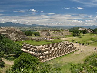
Monte Albán is a large pre-Columbian archaeological site in the Santa Cruz Xoxocotlán Municipality in the southern Mexican state of Oaxaca. The site is located on a low mountainous range rising above the plain in the central section of the Valley of Oaxaca, where the latter's northern Etla, eastern Tlacolula, and southern Zimatlán and Ocotlán branches meet. The present-day state capital Oaxaca City is located approximately 9 km (6 mi) east of Monte Albán.
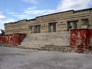
Mitla is the second-most important archeological site in the state of Oaxaca in Mexico, and the most important of the Zapotec culture. The site is located 44 km from the city of Oaxaca, in the upper end of the Tlacolula Valley, one of the three cold, high valleys that form the Central Valleys Region of the state. At an elevation of 4,855 ft, surrounded by the mountains of the Sierra Madre del Sur, the archeological site is within the modern municipality of San Pablo Villa de Mitla. It is 24 mi (38 km) southeast of Oaxaca city. While Monte Albán was the most important politically of the Zapotec centers, Mitla became the main religious one in a later period as the area became dominated by the Mixtec.

Mesoamerican chronology divides the history of prehispanic Mesoamerica into several periods: the Paleo-Indian ; the Archaic, the Preclassic or Formative (2500 BCE – 250 CE), the Classic (250–900 CE), and the Postclassic (900–1521 CE); as well as the post European contact Colonial Period (1521–1821), and Postcolonial, or the period after independence from Spain (1821–present).

San José Mogote is a pre-Columbian archaeological site of the Zapotec, a Mesoamerican culture that flourished in the region of what is now the Mexican state of Oaxaca. A forerunner to the better-known Zapotec site of Monte Albán, San José Mogote was the largest and most important settlement in the Valley of Oaxaca during the Early and Middle Formative periods of Mesoamerican cultural development.
The geography of Mesoamerica describes the geographic features of Mesoamerica, a culture area in the Americas inhabited by complex indigenous pre-Columbian cultures exhibiting a suite of shared and common cultural characteristics. Several well-known Mesoamerican cultures include the Olmec, Teotihuacan, the Maya, the Aztec and the Purépecha. Mesoamerica is often subdivided in a number of ways. One common method, albeit a broad and general classification, is to distinguish between the highlands and lowlands. Another way is to subdivide the region into sub-areas that generally correlate to either culture areas or specific physiographic regions.

The Zapotec civilization was an indigenous pre-Columbian civilization that flourished in the Valley of Oaxaca in Mesoamerica. Archaeological evidence shows that their culture originated at least 2,500 years ago. The Zapotec archaeological site at the ancient city of Monte Albán has monumental buildings, ball courts, magnificent tombs and grave goods, including finely worked gold jewelry. Monte Albán was one of the first major cities in Mesoamerica. It was the center of a Zapotec state that dominated much of the territory which today is known as the Mexican state of Oaxaca.
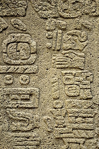
The Zapotec script is the writing system of the Zapotec culture and represents one of the earliest writing systems in Mesoamerica. Rising in the late Pre-Classic era after the decline of the Olmec civilization, the Zapotecs of present-day Oaxaca built an empire around Monte Albán. One characteristic of Monte Albán is the large number of carved stone monuments one encounters throughout the plaza. There and at other sites, archaeologists have found extended text in a glyphic script.
Joyce Marcus is a Latin American archaeologist and professor in the Department of Anthropology, College of Literature, Science, and the Arts at the University of Michigan, Ann Arbor. She also holds the position of Curator of Latin American Archaeology, University of Michigan Museum of Anthropological Archaeology. Marcus has published extensively in the field of Latin American archaeological research. Her focus has been primarily on the Zapotec, Maya, and coastal Andean civilizations of Central and South America. Much of her fieldwork has been concentrated in the Valley of Oaxaca, Mexico. She is known for her "Dynamic model", four-tiered hierarchy, and her use of interdisciplinary study.
Kent Vaughn Flannery is a North American archaeologist who has conducted and published extensive research on the pre-Columbian cultures and civilizations of Mesoamerica, and in particular those of central and southern Mexico. He has also published influential work on origins of agriculture and village life in the Near east, pastoralists in the Andes, and cultural evolution, and many critiques of modern trends in archaeological method, theory, and practice. At the University of Chicago he gained his B.A. degree in 1954; the M.A. in 1961 and a Ph.D. in 1964. From 1966 to 1980 he directed project “Prehistory and Human Ecology of the Valley of Oaxaca, Mexico.” dealing with the origins of agriculture, village life, and social inequality in Mexico. He is James B. Griffin Professor in the Department of Anthropology at the University of Michigan. In 2005, he was elected to the American Philosophical Society.

Cuilapan de Guerrero is a town and municipality located in the central valley region of Oaxaca in southern Mexico. It is 10 kilometres (6.2 mi) to the south of the capital city of Oaxaca on the road leading to Villa de Zaachila, and is in the Centro District in the Valles Centrales region.
Guiengola is a Zapotec archeological site located 14 km (8.7 mi) north of Tehuantepec, and 243 km (151 mi) southeast of Oaxaca city on Federal Highway 190. The visible ruins are located between a hill and a river, each carries the name of Guiengola. The name means "large stone" in the local variant of the Zapotec language. There are two main tombs that have been excavated, and both seem to be family interment sites. Both have front chambers that are for religious idols, while the rear chambers are for the burial of important people. The site also has fortified walls, houses, ballgame fields, other tombs and a very large "palace" with remains of artificial ponds and terraces. In the center of the site are 2 plazas, one lower than the other, and 2 pyramids, one to the east and one to the west.

Yagul is an archaeological site and former city-state associated with the Zapotec civilization of pre-Columbian Mesoamerica, located in the Mexican state of Oaxaca. The site was declared one of the country's four Natural Monuments on 13 October 1998. The site is also known locally as Pueblo Viejo and was occupied at the time of the Spanish Conquest. After the Conquest the population was relocated to the nearby modern town of Tlacolula where their descendants still live.

Lambityeco is a small archaeological site about three kilometers west of the city of Tlacolula de Matamoros in the Mexican state of Oaxaca. It is located just off Highway 190 about 25 km (16 mi) east from the city of Oaxaca en route to Mitla. The site has been securely dated to the Late Classical Period.

Dainzú is a Zapotec archaeological site located in the eastern side of the Valles Centrales de Oaxaca, about 20 km south-east of the city of Oaxaca, Oaxaca State, Mexico. It is an ancient village near to and contemporary with Monte Albán and Mitla, with an earlier development. Dainzú was first occupied 700-600 BC but the main phase of occupation dates from about 200 BC to 350 AD. The site was excavated in 1965 by Mexican archaeologist Ignacio Bernal.
In the Central Valley region of the Southern Mexican state of Oaxaca archeologists discovered evidence of historic settlements. Aztecs from Tenochtitlan on the volcanic plateau to the North around what today is Mexico City first arrived in this region around 1250 AD establishing military rule in the 15th century until the arrival of the Spanish. After the fall of Tenochtitlan, the Spanish took over Oaxaca which led to the eventual decrease of the Native population and the increase in African slaves. The region was then settled by mostly Spanish immigrants from Europe and the African slaves they brought with them. Oaxaca was considered a department after the Mexican War of Independence, but after the fall of emperor Agustín de Iturbide, it became a state in 1824 with José Murguia as its first governor. During the 19th century, Oaxaca was split between liberal and conservative factions. The political and military struggles between the factions resulted in wars and intrigues. A series of major disasters occurred in the state from the 1920s to the 1940s. In the 1940s and 1950s, new infrastructure projects were begun. From the 1980s to the present, there has been much development of the tourism industry in the state.

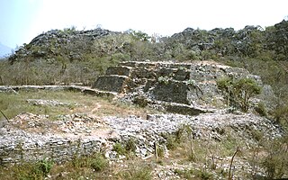
Huamelulpan is an archaeological site of the Mixtec culture, located in the town of San Martín Huamelulpan at an elevation of 2,218 metres (7,277 ft), about 96 kilometres (60 mi) north-west of the city of Oaxaca, the capital of Oaxaca state.
Tierras Largas is a formative-period archaeological site located in the Etla arm in the Valley of Oaxaca in Mexico. It is considered to be one of the first villages where sedentism originated in the Oaxaca area. The name is Spanish for “Long Lands”.
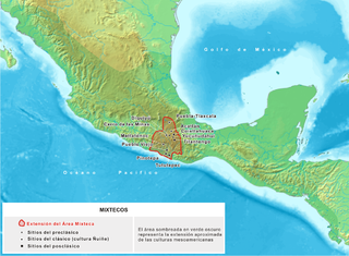
The Mixtec culture was a pre-hispanic archaeological culture, corresponding to the ancestors of the Mixtec people; they called themselves ñuu Savi, which means "people or nation of the rain". It had its first manifestations in the Mesoamerican Middle Preclassic period and ended with the Spanish conquest in the first decades of the 16th century. The historical territory of this people is the area known as La Mixteca, a mountainous region located between the current Mexican states of Puebla, Oaxaca, and Guerrero.


