Ocean to Ocean Bridge

Last updated
Ocean-to-Ocean Bridge
Ocean to Ocean Bridge, Yuma, AZ.jpg
Coordinates 32°43′43″N114°36′56″W / 32.7287°N 114.6156°W / 32.7287; -114.6156
CarriesPenitentiary Avenue, pedestrians and bicycles
US 80 (AZ historic).svg Historic US 80
Crosses Colorado River
Locale Yuma, Arizona, US
Named for Ocean-to-Ocean Highway
Owner Yuma County, Arizona
Inventory No.08533
Characteristics
Design Through truss bridge
MaterialSteel
Pier constructionConcrete
Total length444 ft (135 m)
Width35 ft (11 m)
Longest span336 ft (102 m)
No. of spans2
Piers in water1
History
Designer Bureau of Indian Affairs
Constructed by Omaha Structural Steel Works
Construction startSeptember 1914
Construction end1915
Construction cost$73,800 ($1.6 million as of 2022)
Opened22 May 1915
Rebuilt1943; 2002
Ocean to Ocean Bridge
USA Arizona relief location map.svg
Red pog.svg
Ocean to Ocean Bridge
Usa edcp relief location map.png
Red pog.svg
Ocean to Ocean Bridge
Nearest city Yuma, Arizona
Coordinates 32°43′43″N114°36′56″W / 32.7287°N 114.6156°W / 32.7287; -114.6156
Area0.2 acres (0.081 ha)
Built1914 (1914)
Built by Omaha Structural Steel Works, Office of Indian Affairs
MPS Vehicular Bridges in Arizona MPS
NRHP reference No. 79000431 [1]
Added to NRHPSeptember 11, 1979
Location
Ocean to Ocean Bridge

The Ocean-to-Ocean Bridge is a through truss bridge spanning the Colorado River in Yuma, Arizona. Built in 1915, it was the first highway crossing of the lower Colorado and is the earliest example of a through truss bridge in Arizona. It is also the only example of a Pennsylvania truss within Arizona. Originally the bridge carried the transcontinental Ocean-to-Ocean Highway and later carried its successor, US 80 until a new bridge was built to the west in 1956. Between 1988 and 2001, the bridge was closed to vehicular traffic and only traversable by pedestrians and bicyclists. After a major restoration, the bridge was rehabilitated and reopened to vehicular traffic in 2002, with a re-dedication by the Quechan nation and Yuma Crossing National Heritage Area. The bridge became part of Historic US 80 in 2018.

Contents

History

In 1913, following massive pressure against Arizona Congressman Carl Hayden by the citizens of Yuma, Hayden lobbied Congress, proposing federal aid be used for construction of a permanent highway crossing spanning the lower Colorado River. [2] [3] Congress authorized the construction of the bridge under the pretense that it was to be used in connecting Yuma to the Fort Yuma Indian Reservation located on the opposing bank of the river. Because of this justification, the federal funding was provided through the Office of Indian Affairs (OIA). Further capital was raised and provided by the State of Arizona and Imperial County, California, each providing $25,000 (which is $547,310 as of 2022). [2] [4] OIA engineers in Washington D.C. were tasked with designing the new bridge. The new bridge design was to be a steel, Pennsylvania through truss design complemented by a Warren deck truss second span, both resting upon concrete piers and abutments above the river. The location of the bridge was to be upstream from an existing ferry crossing at Prison Hill Road. [2]

The Omaha Structural Steel Works was awarded the construction contract by the OIA in June 1914, at a cost of $73,800 (which is $1.6 million as of 2022). [3] [4] Construction on the bridge began in September 1914. [3] Between October and February, problems arose constructing the bridge, as both Omaha Steel and the OIA were unfamiliar with the currents and flood patterns of the lower Colorado. Falsework erected to aid in the bridge's construction were twice washed downstream by floods. [2] [3] Omaha Steel decided to approach construction of the twin span bridge by a different method; constructing the spans on barges and floating each span down river into position. The 336 ft (102 m) span was floated down river and swung into place carefully and methodically on March 3, 1915, followed by local praise and celebration. Following completion, the Ocean-to-Ocean Bridge was ceremoniously opened to the public on May 22, 1915. The bridge became a crucial link in the nationwide transcontinental Ocean-to-Ocean Highway and was also the first highway bridge across the lower Colorado River. [2]

On November 11, 1926, the bridge became part of U.S. Route 80. [5] [6] The successor to the earlier Ocean-to-Ocean Highway, US 80 became the primary east to west transcontinental highway in Arizona and between the 1920s and 1930s, carried the majority of the state's auto traffic. [2] During the Great Depression in the 1930s, the Ocean-to-Ocean Bridge was used by California state police officers to deny entry refugees of the dust bowl hailing from Oklahoma intending to find work in California. Often called "Okies", these people found work instead around Yuma, County between Yuma and Wellton. The refugees soon provided critically needed assistance to local farmers. [3]

In 1956, US 80 was re-routed off the Ocean-to-Ocean Bridge and onto a newer bridge built downstream at the foot of Fourth Avenue. [5] Following construction of the Fourth Avenue Bridge and the construction of Interstate 8 in the early 1970s, vehicular traffic and importance of the Ocean-to-Ocean Bridge steadily declined. [3] Similarly, the historic transcontinental highway which the bridge had once carried, US 80, declined and was removed from San Diego to Benson between 1964 and 1977, no longer running through Yuma. [6] In 1978, the bridge was added to the National Register of Historic Places. Despite the newly gained honor, vehicular traffic was no longer allowed to use the bridge after 1988. In 2001, a $3 million restoration and rehabilitation project was begun, temporarily closing the bridge to pedestrians as well. Following the extensive restoration and a re-dedication ceremony, the bridge was re-opened to traffic in 2002 and now carries Penitentiary Avenue. [3] The Ocean-to-Ocean Bridge was designated as part of Historic U.S. Route 80 by the Arizona Department of Transportation on September 21, 2018. [7]

See also

Related Research Articles

<span class="mw-page-title-main">Navajo Bridge</span> Bridge pair in Arizona, United States

Navajo Bridge is the name of twin steel spandrel arch bridges that cross the Colorado River in the Grand Canyon National Park in northern Coconino County, Arizona, United States. The newer of the two spans carries vehicular traffic on U.S. Route 89A (US 89A) over Marble Canyon between Bitter Springs and Jacob Lake, allowing travel into a remote Arizona Strip region north of the Colorado River including the North Rim of Grand Canyon National Park.

<span class="mw-page-title-main">Memphis & Arkansas Bridge</span> Highway bridge in Memphis, Tennessee, United States

The Memphis & Arkansas Bridge, also known as the Memphis–Arkansas Bridge or inaccurately as the Memphis–Arkansas Memorial Bridge, is a cantilevered through truss bridge carrying Interstate 55 across the Mississippi River between West Memphis, Arkansas and Memphis, Tennessee. Memphians refer to this bridge as the "Old Bridge" to distinguish it from the "New Bridge", or Hernando de Soto Bridge, upstream.

<span class="mw-page-title-main">Gillespie Dam</span> Dam in Maricopa County, Arizona

The Gillespie Dam is a concrete gravity dam located on the Gila River between the towns of Buckeye and Gila Bend, Arizona. The dam was constructed during the 1920s for primarily irrigation purposes. It was key to the development of a 72,000-acre (29,000 ha) parcel owned by "millionaire" W.S. Gillespie of Tulsa, Oklahoma, initially allowing for irrigation of 10,000 acres (4,000 ha). A portion of the dam failed unexpectedly in 1993 during unusually heavy rains.

<span class="mw-page-title-main">Chevelon Creek Bridge</span> Historic bridge in Arizona, U.S.

Chevelon Creek Bridge is a historic road bridge located about 12 miles (19 km) southeast of Winslow, in Navajo County, eastern Arizona, United States. It is a steel Warren Pony truss bridge over Chevelon Creek, built on the first permanent road connecting Holbrook, the seat of Navajo County, and Winslow. When built, the road was regionally important in northern Arizona as well as being a segment of an early national highway at the time automobile traffic was growing and national roads were first being formed. The bridge was listed on the National Register of Historic Places in 1983 for being a rare design in Arizona, part of an early transnational roadway, one of the first bridges built by Arizona after statehood in 1912, and being in nearly original condition.

<span class="mw-page-title-main">Kettle Falls Bridges</span> Bridge in Kettle Falls, Washington

The Kettle Falls Bridges is the collective name for a pair of steel cantilever bridges carrying State Route 20/U.S. Route 395 and the Kettle Falls International Railway across the Columbia River at Kettle Falls, Washington. The south bridge carries motor vehicle traffic while the similar northern span is used for rail.

<span class="mw-page-title-main">U.S. Route 80 in Arizona</span> 1926–1989 American highway

U.S. Route 80 (US 80), also known as the Ocean-to-Ocean Highway, the Broadway of America and the Jefferson Davis Memorial Highway, was a major transcontinental highway that existed in the U.S. state of Arizona from November 11, 1926, to October 6, 1989. At its peak, US 80 traveled from the California border in Yuma to the New Mexico state line near Lordsburg. US 80 was an important highway in the development of Arizona's car culture. Like its northern counterpart, US 66, the popularity of travel along US 80 helped lead to the establishment of many unique roadside businesses and attractions, including many iconic motor hotels and restaurants. US 80 was a particularly long highway, reaching a length of almost 500 miles (800 km) within the state of Arizona alone for most of the route's existence.

<span class="mw-page-title-main">Red River Bridge (Arkansas)</span> United States historic place

The Red River Bridge was a truss bridge crossing the Red River at Garland, Arkansas. It carried vehicular traffic from 1931 to 1990 and has since been demolished.

<span class="mw-page-title-main">Montopolis Bridge</span> Historic bridge in Austin, Texas

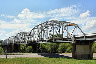
The Montopolis Bridge is a historic Parker through truss bridge in Austin, Texas. It is located in the Montopolis neighborhood where a bicycle and pedestrian walkway crosses the Colorado River in southeastern Travis County. The bridge consists of five 200-foot Parker through truss spans and four 52-foot steel I-beam approach spans resting on reinforced concrete abutments. It was added to the National Register of Historic Places on October 10, 1996.

<span class="mw-page-title-main">Cameron Suspension Bridge</span> Historic bridge in Coconino County, Arizona

The Cameron Suspension Bridge crosses the Little Colorado River at Cameron, Arizona, United States.

<span class="mw-page-title-main">AJX Bridge over South Fork and Powder River</span> United States historic place

The AJX Bridge is a historic Pratt truss bridge in southwestern Johnson County, Wyoming. The bridge was built in 1931 across the South Fork of the Powder River near Kaycee, Wyoming. AJX Bridge was built to provide a river crossing for U.S. Route 87. It was placed on the National Register of Historic Places in 1985 as part of a Multiple Property Submission devoted to historic bridges in Wyoming.

<span class="mw-page-title-main">Ciénega Bridge</span> Historic bridge in Pima County, Arizona

Ciénega Bridge is an open-spandrel arch bridge which crosses Ciénega Creek and the Union Pacific Railroad near Vail, Arizona. Originally constructed in 1921, the bridge was part of U.S. Route 80, a major transcontinental highway, from 1926 to 1956. Being the oldest bridge of its kind in Arizona, the Ciénega Bridge is listed on the National Register of Historic Places. The bridge also holds the title of being the longest open-spandrel concrete arch bridge within the state. Currently, the bridge carries Marsh Station Road, which is part of Historic U.S. Route 80 as of 2018.

The Antelope Hill Highway Bridge is a historic bridge over the Gila River in Tacna, Arizona, U.S. It was built between 1914 ad 1915 as a ten-span concrete girder bridge. The bridge served as an integral piece of the Ocean to Ocean Highway between Yuma and Phoenix from 1915 to 1922, when it was bypassed by an alternate route through Gila Bend, paralleling the Gillespie Dam. The bridge and original highway were bypassed mainly due to damage caused by flooding along the river floodplain it was constructed on. After being repurposed for traffic traveling north from Yuma, the bridge was finally abandoned in 1929 following completion of the McPhaul Suspension Bridge. The ruins of the old bridge are currently listed on the National Register of Historic Places.

<span class="mw-page-title-main">Holmes Street Bridge</span> United States historic place

The Holmes Street Bridge, also known the Holmes Street Pedestrian Bridge, Old Shakopee Bridge, or Bridge 4175, is a historic truss bridge over the Minnesota River in Shakopee, Minnesota, United States. It is one of the state's only examples of a deck truss bridge. It was constructed in 1927 with parts manufactured by the Minneapolis Steel & Machinery Company. The bridge formerly carried US 169 and MN 101, and served as the principal river crossing for Shakopee. The Holmes Street Bridge was closed to vehicular traffic in 2005. It was rehabilitated in 2011 to carry a trail for pedestrians, cross-country skiers, and snowmobiles.

<span class="mw-page-title-main">Straight Street Bridge</span> Bridge in Paterson, New Jersey

The Straight Street Bridge is a vehicular bridge over the Passaic River in Paterson, New Jersey, that is listed on the National Register of Historic Places.

<span class="mw-page-title-main">Hassayampa Bridge</span> United States historic place

The Hassayampa Bridge is a bridge spanning the Hassayampa River in Hassayampa, Arizona, located in Maricopa County. The bridge was completed in 1929 and was listed on the National Register of Historic Places in 1988. The bridge was scheduled for demolition in 1983.

<span class="mw-page-title-main">Red Rock Bridge</span> Former Colorado River bridge in Arizona

The Red Rock Bridge was a bridge across the Colorado River at Topock, Arizona that carried the Atlantic & Pacific Railroad. It was built in 1890, replacing a wooden bridge dating to 1883 that was repeatedly washed out during spring flooding. It was used by the railroad until 1945 when a new bridge was built. The Red Rock Bridge was then converted to carry the automobile traffic of U.S. Route 66, and did so from 1947 until 1966 when Route 66 traffic was directed onto the Interstate 40 bridge. At that time the Red Rock Bridge was abandoned, and it was eventually dismantled in 1976.

<span class="mw-page-title-main">Gillespie Dam Bridge</span> NRHP registered place in Maricopa County, Arizona

The Gillespie Dam Bridge is a through truss bridge spanning the Gila River in Maricopa County, in the U.S. state of Arizona. The bridge was constructed to bypass a concrete apron through the river in front of the Gillespie Dam, which was often closed due to flooding. Construction of the bridge started in 1925 and completed in 1927. From its opening until 1956, the bridge was part of U.S. Route 80 (US 80), a transcontinental highway between San Diego, California and Tybee Island, Georgia. The bridge was restored in 2012 by Maricopa County for the Arizona Centennial and now includes an educational interpretive center for visitors. The bridge became part of Historic US 80 in 2018.

Sanders Bridge is a steel truss bridge straddling the Puerco River, near Sanders, Arizona. It was constructed in 1923 and gained National Historic status in 1988.

<span class="mw-page-title-main">Rifle Bridge</span> United States historic place

The Rifle Bridge, over the Colorado River in Rifle, Colorado, was built in 1909. It was listed on the National Register of Historic Places in 1985.

The Black River Bridge near Carrizo, Arizona was funded in 1911 and built in 1912. It was listed on the National Register of Historic Places in 1988. It spans the Black River, bringing an army road, now Indian Route 9, over the river from Fort Apache to the railroad at the former town of Rice, Arizona.

References

  1. "National Register Information System". National Register of Historic Places . National Park Service. July 9, 2010.
  2. 1 2 3 4 5 6 State of Arizona (31 October 2004). "Historic Property Inventory Forms – Yuma Bridges" (PDF). Inventory Records. Arizona Department of Transportation (ADOT). Retrieved 27 August 2016.
  3. 1 2 3 4 5 6 7 McDaniel, Chris (29 May 2011). "Ocean to Ocean Bridge critical link between shores". News Article. Yuma Sun. Retrieved 27 August 2016.
  4. 1 2 Johnston, Louis; Williamson, Samuel H. (2023). "What Was the U.S. GDP Then?". MeasuringWorth. Retrieved November 30, 2023. United States Gross Domestic Product deflator figures follow the Measuring Worth series.
  5. 1 2 Jensen, Jeff (2013). Drive the Broadway of America!. Tucson, Arizona: Bygone Byways. pp. 94, 204. ISBN   978-0978625900.
  6. 1 2 Weingroff, Richard (18 November 2015). "U.S. Route 80 The Dixie Overland Highway". Webpage. Federal Highway Administration. Retrieved 1 September 2016.
  7. "Historic Arizona U.S. Route 80 Designation". Webpage. Tucson Historic Preservation Foundation. August 2017. Retrieved 23 August 2018.