Ockbrook

Last updated

Ockbrook
Quuens head ockbrook.jpg
Quuens Head
Derbyshire UK location map.svg
Red pog.svg
Ockbrook
Location within Derbyshire
Population7,335 (2011)
OS grid reference SK424360
Civil parish
District
Shire county
Region
Country England
Sovereign state United Kingdom
Post town Derby
Postcode district DE72
Dialling code 01332
Police Derbyshire
Fire Derbyshire
Ambulance East Midlands
UK Parliament
List of places
UK
England
Derbyshire
52°55′12″N1°22′20″W / 52.92000°N 1.372354°W / 52.92000; -1.372354

Ockbrook is a village in the Erewash district, in the county of Derbyshire, England. It is almost contiguous with the village of Borrowash, the two only separated by the A52. The civil parish is Ockbrook and Borrowash. The population of this civil parish at the 2011 Census was 7,335. [1] Ockbrook lies about 5 miles (8.0 km) east of Derby.

Contents

History

There is evidence of human activity in Ockbrook as far back as the Mesolithic period (~8000BC) in the form of two bifacial cores of flint. A small greenstone axe head attests to Neolithic activity (4000 - 2500BC, but no archaeological evidence has yet been discovered of Bronze Age activity in the village. [2] From the Iron Age (800BC - AD43) there is a variety of evidence obtained during the excavation of a Romano-British aisled building at Littlehay Grange Farm between 1994 and 1997. This includes sherds of Ancaster Breedon scored ware and Aylesford-Swarling Pottery, a Group A one-piece brooch, an Iron Age coin of silver dating to between 40 BC and 10 AD, and an Iron Age ring headed pin or spike. [2]

Evidence of occupation during the Roman period (AD43 - 410) includes the sites of three farmsteads, one of which has been excavated. From these it appears that the fortunes of the area at that time mirrored those of nearby Derventio (Roman Derby), with a boom starting during the 2nd century AD followed by abandonment at the end of the 4th century. [2] During the early Dark Ages, Ockbrook was part of the Kingdom of Mercia. According to the Anglo-Saxon Chronicle , this was founded in 560 by Creoda, one of whose followers may have had the personal name Occa. [2] It was this Occa (an Anglo Saxon) who established Ockbrook in the 6th century on the banks of a small stream, the Ock. [2]

During the ninth century, the Danes invaded and swept through large swathes of England until fought to a standstill by Alfred the Great. The country was partitioned as a consequence c874 and Ockbrook, being east of Watling Street (the present day A5) would have been in the Danelaw. This period is attested to by two place names, The Ridings and Carrhill, which derive from Danish. Despite frequent skirmishes between Danes and the English hereabouts, the Danelaw survived until 1066 when, according to the Domesday Book, the manor was held by Toki (probably a Dane). [2] The entry reads:

"...In Ockbrook Tochi had four carucates of land (assessed) to the geld, land for four ploughs. There are now ten villeins and two Bordars having three ploughs and four rent paying tenants rendering 14 shillings. There are five acres of meadow, woodland for pannage one league in length and half a league wide. In King Edward’s day worth £4 now 40shillings belonging to the Bishop of Chester...". [2]


By 1086 the manor had been transferred either to the extensive holdings of Geoffrey Alselin or to the Bishop of Chester (according to Domesday), both of whom were Norman. c1130 it was divided between two sons of Sir Ralph Halselin whence half descended to the Bardolfs of Wormegay (who sold it to the Foljambe's c1420) and half to Serlo de Grendon who granted it to Dale Abbey. At the Reformation, these shares were largely broken up amongst the freeholders, notably the Battelles, Harpurs, Keyes (of Hopwell) and Wilmots (of Chaddesden). [3]

In 1750 the Moravian Church established a settlement here, one of only three remaining in the country. This was on the edge of the old village and separate from it. The buildings are Georgian red brick and two of them, the Manse (1822) and the chapel (1751–1752) are grade II listed. [lower-alpha 1] From the early 19th century, middle-class families from Derby and Long Eaton took advantage of the fragmented landowning pattern to acquire land and build elegant villas. [3] Also during this period, work diversified to include four silk glove makers, four shoemakers, and a straw bonnet maker. [4]
In more recent times, extensive new housing developments have turned Ockbrook into a commuter dormitory for Derby.

  1. Ockbrook Historical Trail, Ockbrook and Borrowash Historical Society, Derbyshire County Council.

Sport

Cricket

History of cricket dates back to the mid nineteenth century, where a match report was recorded between Ockbrook and "Sawley Club" in 1843. [5] Ockbrook & Borrowash Cricket Club moved to the current ground on Victoria Avenue in 1898. In 1999, Ockbrook & Borrowash CC became the first champions of the newly formed Premier Division of the Derbyshire County Cricket League; [6] the top level for recreational club cricket in Derbyshire, England, and is a designated ECB Premier League. The club has continued to gain high acclaim and has since added a further 5 Championship ECB Premier league titles to its tally: 2005, 2006, 2009, 2011, and 2014. [7] [8]

Football

Ockbrook Football Club. [9]

Golf

Borrowood Golf Club was founded in 1902 as a 9-hole course. It was laid out on farmland south of Borrow Wood Farm between the villages of Ockbrook and Spondon. The club closed in the early 1950s. [10]

Area and population growth

The area of the village is 1,730 acres (700 ha). [3]

The population growth figures include Borrowash [3] Source: Email from Census Customer Services.

Ockbrook and Borrowash Population Growth.png

1801181118211831184118511861187118811891
8279341,2031,6341,7651,7631,5061,6331,9382,166
1901191119211931194119511961197119811991
2,5672,8072,9692,9713,3733,7755,2787,1077,4367,092
20012011
7,3317,335


    Schools

    Churches

    Lych Gate of All Saints Parish Church Lych Gate of All Saints Parish Church Ockbrook.jpg
    Lych Gate of All Saints Parish Church
    1. 1 2 Ockbrook Historical Trail, Ockbrook and Borrowash Historical Society, Derbyshire County Council.

    Pubs

    1. Ockbrook Historical Trail, Ockbrook and Borrowash Historical Society, Derbyshire County Council.

    Amenities

      Streets, gitties and footpaths

      This list of streets is taken from Street list from Streetmap.co.uk

      • Anne Potter Close
      • Bakehouse Lane
      • Bare Lane – See note below
      • Cedar Drive
      • Church Street
      • Cole Lane
      • Collier Lane
      • Collumbell Avenue
      • Croft Close
      • Far Lane: The ancient hedgerows along its upper reaches indicate that this is a very old track, probably dating from the Mesolithic. It is possible that it once connected with the Port-ways i.e. the rivers Derwent and Trent. [lower-alpha 1]
      • Flood Street
      • Green Lane – See note below
      • Hargrave Avenue
      • Hill Croft Drive
      • Homefarm Close
      • Moor Lane – See note below
      • New Street
      • Oak Close
      • Orchard Close
      • Pares Way
      • Ryal Close
      • Shop Stones
      • Sisters Lane
      • The Paddock
      • The Ridings: The name is Danish either for a clearing or a similar-sounding word meaning a third division. [lower-alpha 1]
      • The Settlement
      • Top Manor Close
      • Victoria Avenue
      • Wesley Lane
      • Windmill Close
      • Yew Tree Avenue


      1. 1 2 Ockbrook Historical Trail, Ockbrook and Borrowash Historical Society, Derbyshire County Council.

      The quickest route between two points in the village is often via a gitty . These were originally footpaths through fields. They have survived the encroachment of housing by mutating into high walled or fenced alleyways between the buildings and gardens of the new (and old) developments.

      • Gitty between old buildings. Gitty between old buildings in Ockbrook.jpg
        Gitty between old buildings.
      • Gitty between new buildings. Gitty between new buildings in Ockbrook.jpg
        Gitty between new buildings.

      Numerous footpaths start at the village boundary (often as the continuation of a street or gitty) and lead over the fields to neighbouring villages, Hamlet_(place) and farms.

      Historic maps (in chronological order)


      OS = Ordnance Survey. OS sheets use Roman numerals, so L = 50.

      This list is incomplete.

      See also

      Related Research Articles

      <span class="mw-page-title-main">Spondon</span> Human settlement in England

      Spondon is a ward of the city of Derby, England. Originally a small village, Spondon dates back to the Domesday Book and it became heavily industrialised in the 19th and early 20th centuries, with companies such as British Celanese.

      <span class="mw-page-title-main">Heanor</span> Town in Derbyshire, England

      Heanor (/ˈhiːnə/) is a town in the Amber Valley district of Derbyshire in the East Midlands of England. It lies 8 miles (13 km) north-east of Derby and forms, with the adjacent village of Loscoe, the civil parish and town council-administered area of Heanor and Loscoe, which had a population of 17,251 in the 2011 census.

      <span class="mw-page-title-main">Baslow</span> Village in Derbyshire, England

      Baslow is a village in Derbyshire, England, in the Peak District, situated between Sheffield and Bakewell, just over 1 mile (1.6 km) north of Chatsworth House. It is sited by the River Derwent, which is spanned by a 17th-century bridge, alongside which is a contemporary toll house.

      <span class="mw-page-title-main">Chellaston</span> Village on outskirts of Derby, England

      Chellaston is a suburban village on the southern outskirts of Derby, in Derbyshire, England.

      <span class="mw-page-title-main">Alvaston</span> Human settlement in England

      Alvaston is a village and ward of Derby, England. Alvaston is on the A6 three miles south-east of Derby city centre and probably owes its name to an individual called Ælfwald.

      <span class="mw-page-title-main">Risley, Derbyshire</span> Village and parish in Derbyshire, England

      Risley is a small village and parish in the Borough of Erewash in Derbyshire, England. The population of the civil parish as of the 2011 census was 711. It is four miles south of Ilkeston.

      <span class="mw-page-title-main">Ticknall</span> Village in South Derbyshire, England

      Ticknall is a small village and civil parish in South Derbyshire, England. The population of the civil parish at the 2011 Census was 642. Situated on the A514 road, close to Melbourne, it has three pubs, several small businesses, and a primary school. Two hundred years ago it was considerably larger and noisier with lime quarries, tramways and potteries. Coal was also dug close to the village. Close to the village is Calke Abbey, now a National Trust property.

      <span class="mw-page-title-main">Swarkestone</span> Human settlement in England

      Swarkestone is a village and civil parish in the South Derbyshire district of Derbyshire, England. The population at the 2011 Census was 187.

      <span class="mw-page-title-main">Ockbrook and Borrowash</span> Civil parish in Derbyshire, England

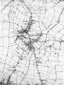
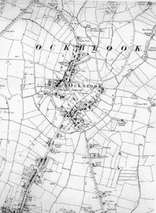
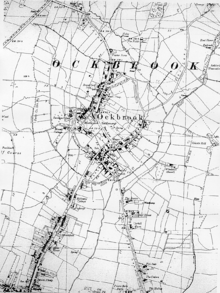
      Ockbrook and Borrowash is a civil parish in the borough of Erewash in the county of Derbyshire in England.

      <span class="mw-page-title-main">Draycott and Church Wilne</span> Civil parish in England

      Draycott and Church Wilne is a civil parish within the Borough of Erewash, which is in the county of Derbyshire, England. Partially built up and otherwise rural, its population was 3,090 residents in the 2011 census. The parish is 100 miles (160 km) north west of London, 5+12 miles (8.9 km) south east of the county city of Derby, and 3 miles (4.8 km) west of the nearest market town of Long Eaton. It shares a boundary with the parishes of Breaston, Elvaston, Hopwell, Ockbrook and Borrowash, Risley and Shardlow and Great Wilne.

      <span class="mw-page-title-main">Sawley, Derbyshire</span> Village and civil parish in Derbyshire, England

      Sawley is a village and civil parish within the Borough of Erewash, in southeast Derbyshire, England. With a slightly higher than average number of people over 65, the population of just the civil parish was measured at 6,629 as at the 2011 Census.

      <span class="mw-page-title-main">Borrowash</span> Human settlement in England

      Borrowash is a village in the Erewash district of Derbyshire, England, situated immediately east of the Derby city boundary. The appropriate civil parish is called Ockbrook and Borrowash.

      <span class="mw-page-title-main">Stanton by Dale</span> Human settlement in England

      Stanton by Dale, also written as Stanton-by-Dale, is a village and civil parish in the south east of Derbyshire, England. According to the University of Nottingham English Place-names project, the settlement name Stanton-by-Dale could mean 'Stony farm or settlement', stān for stone or rock; and tūn for an enclosure; farmstead; village; or an estate. It lies 2.65 miles (4.26 km) south of Ilkeston and 1.31 miles (2.11 km) north of Sandiacre. Since 1974 it has been part of the Erewash borough. The village is halfway between the cities of Derby 6.98 miles (11.23 km) and Nottingham 6.81 miles (10.96 km), as the crow flies, from each city. The population of the civil parish at the 2011 census was 505.

      <span class="mw-page-title-main">All Saints' Church, Ockbrook</span> Church in United Kingdom

      All Saints' Church, Ockbrook, is a parish church in the Church of England located in Ockbrook, Derbyshire.

      Ian John Darlington is an English cricketer. Darlington is a right-handed batsman who bowls right-arm medium pace. He was born at Derby, Derbyshire.

      Swarkestone Cricket Club is a cricket club based in Swarkestone, 5 miles south of Derby, and has a history dating back to the early 20th century.

      <span class="mw-page-title-main">St Stephen's Church, Borrowash</span> Church in Derbyshire, England

      St Stephen's Church, Borrowash is a parish church in the Church of England in Borrowash, Derbyshire.

      <span class="mw-page-title-main">Ticknall Cricket Club</span> Cricket club in England

      Ticknall Cricket Club is an amateur cricket club based in Ticknall, Derbyshire, England. The origin of the club is unknown, but it is locally believed that Ticknall's relationship with cricket began in the mid-19th century.

      <span class="mw-page-title-main">Ockbrook & Borrowash Cricket Club</span> Amateur cricket club in Derbyshire, England

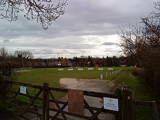
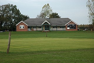
      Ockbrook & Borrowash Cricket Club is an amateur cricket club based in Ockbrook, Derbyshire, England. The club has a history dating back to the mid 19th century.

      Ockbrook and Borrowash is a civil parish in the Borough of Erewash, Derbyshire, England. The parish contains 36 listed buildings that are recorded in the National Heritage List for England. Of these, three are listed at Grade II*, the middle of the three grades, and the others are at Grade II, the lowest grade. The parish contains the villages of Ockbrook and Borrowash and the surrounding area. From the middle of the 18th century a Moravian settlement was established in Ockbrook, and a number of buildings associated with it are listed, including the chapel, the manse, a school and houses in The Settlement. Most of the other listed buildings are houses, farmhouses and associated structures, and the rest include a church and associated structures, a canal bridge, and two war memorials.

      References

      1. "Civil parish population 2011". Neighbourhood Statistics. Office for National Statistics. Retrieved 29 March 2016.
      2. 1 2 3 4 5 6 7 Palfreyman, Alan (1999). Ockbrook Before Domesday. Derbyshire: Ockbrook and Borrowash Historical Society.
      3. 1 2 3 4 5 6 Craven, Maxwell (1996). The Illustrated History of Derby's Suburbs. Breedon Books Publishing Co Ltd. ISBN   1-85983-031-5.
      4. 1 2 3 4 Derbyshire Federation of Women's Institutes (2002). Derbyshire Villages. Countryside Books. ISBN   978-1853067488.
      5. The History of Cricket in Long Eaton, Sandiacre & Sawley, 1994, Keith Breakwell. ISBN   978-0-9521-4371-0
      6. "Derbyshire Leagues". play-cricket.com. Retrieved 29 January 2021.
      7. Derbyshire Marston's Pedigree County Cricket League Centenary Yearbook. Derbyshire: DCCL. 2019. pp. 137–145.
      8. "DCCL Competition results". Derbyshire Cricket League. Retrieved 14 February 2021.
      9. "Ockbrook Football Club in old photographs". picturethepast.org.uk. Retrieved 29 January 2021.
      10. "Borrowood Golf Club". golfsmissinglinks.co.uk. Retrieved 28 January 2021.

      Further reading

      Derbyshire flag.svg