
The Rio Grande in the United States or the Río Bravo in Mexico is one of the principal rivers in the southwestern United States and in northern Mexico. The length of the Rio Grande is 1,896 miles (3,051 km), making it the 4th longest river in the United States and in North America by main stem. It originates in south-central Colorado, in the United States, and flows to the Gulf of Mexico. The Rio Grande drainage basin (watershed) has an area of 182,200 square miles (472,000 km2); however, the endorheic basins that are adjacent to and within the greater drainage basin of the Rio Grande increase the total drainage-basin area to 336,000 square miles (870,000 km2).

Presidio County is a county located in the U.S. state of Texas. As of the 2020 census, its population was 6,131. Its county seat is Marfa. The county was created in 1850 and later organized in 1875. Presidio County is in the Trans-Pecos region of West Texas and is named for the border settlement of Presidio del Norte. It is on the Rio Grande, which forms the Mexican border.

Presidio is a city in Presidio County, Texas, United States. It is situated on the Rio Grande River, on the opposite side of the U.S.–Mexico border from Ojinaga, Chihuahua. The name originates from Spanish and means "fortress". The population was 4,169 at the 2000 census, and had increased to 4,426 as of the 2010 US census.

A presidio was a fortified base established by the Spanish Empire between the 16th and 18th centuries in areas under their control or influence. The term is derived from the Latin word praesidium meaning protection or defense.
Los Rieleros del Norte are a Mexican three-time Grammy-nominated regional Mexican band from Ojinaga, Chihuahua, Mexico. They are based in El Paso, Texas, United States, and specialize in the norteño-sax genre.

Ojinaga Municipality is one of the 67 municipalities of Chihuahua, in northern Mexico. The municipal seat lies at Ojinaga, a rural bordertown on the U.S.-Mexico border. The municipality has an area of 9,500.50 km2.
The Rio Grande has changed course several times in recorded history, leading to a number of border disputes and uncertainties, both international and between individual U.S. states:
The Ojinaga Cut is a parcel of land between Ojinaga, Chihuahua, and Presidio, Texas, that gave rise to an international border dispute between the United States and Mexico when the Rio Grande changed course.
The Boundary Treaty of 1970 is a treaty between the United States and Mexico that settled all outstanding boundary disputes and uncertainties related to the Rio Grande border between them.
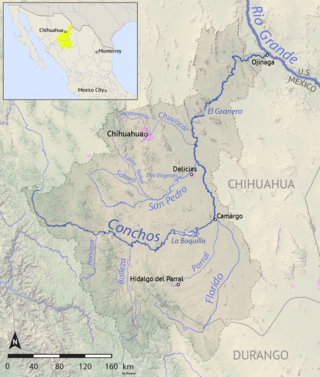
The Río Conchos is a large river in the Mexican state of Chihuahua. It joins the Río Bravo del Norte at the town of Ojinaga, Chihuahua.

The Camino Real de Tierra Adentro, also known as the Silver Route, was a Spanish 2,560-kilometre-long (1,590 mi) road between Mexico City and San Juan Pueblo, New Mexico, that was used from 1598 to 1882. It was the northernmost of the four major "royal roads" that linked Mexico City to its major tributaries during and after the Spanish colonial era.
Federal Highway 2 is a free part of the Mexican federal highway corridors that runs along the U.S. border. The highway is in two separate improved segments, starting in the west at Tijuana, Baja California, on the Pacific coast and ending in the east in Matamoros, Tamaulipas, on the Gulf of Mexico. Fed. 2 passes through the border states of Baja California, Sonora, Chihuahua, Coahuila, Nuevo Leon and Tamaulipas. It has a total length of 1,987 kilometres (1,235 mi); 1,343 kilometres (835 mi) in the west and 644 kilometres (400 mi) in the east.

Pablo Acosta Villarreal, commonly referred to as El Zorro de Ojinaga was a Mexican narcotics smuggler who controlled crime along a 200-mile stretch of U.S.-Mexico border. At the height of his power, he was smuggling 60 tons of cocaine per year for Colombian cartels in addition to the large quantities of marijuana and heroin that were the mainstay of his business. He was the mentor and business partner of Amado Carrillo Fuentes, the "Lord of the Skies", who took over after Acosta's death.
The Presidio–Ojinaga International Bridge, also known simply as the Presidio Bridge and Puente Ojinaga, is an international bridge that crosses the Rio Grande between the cities of Presidio, Texas, and Ojinaga, Chihuahua, on the United States–Mexico border. It connects U.S. Route 67 to the north with Mexican Federal Highway 16 to the south. The bridge is privately owned and is tolled. It was completed and opened in 1985. The bridge is two lanes wide and 791 feet (241 m) long.
Aldama is a city and seat of the municipality of Aldama in the northern Mexican state of Chihuahua. As of 2020, the city had a population of 22,568 inhabitants.
Jumanos were a tribe or several tribes, who inhabited a large area of western Texas, New Mexico, and northern Mexico, especially near the Junta de los Rios region with its large settled Indigenous population. They lived in the Big Bend area in the mountain and basin region. Spanish explorers first recorded encounters with the Jumano in 1581. Later expeditions noted them in a broad area of the Southwest and the Southern Plains.
The Presidio–Ojinaga International Rail Bridge is an international bridge that crosses the Rio Grande between the cities of Presidio, Texas, and Ojinaga, Chihuahua, on the United States-Mexico border.
La Junta Indians is a collective name for the various Indians living in the area known as La Junta de los Rios on the borders of present-day West Texas and Mexico. In 1535 Alvar Nunez Cabeza de Vaca recorded visiting these peoples while making his way to a Spanish settlement. They cultivated crops in the river floodplains, as well as gathering indigenous plants and catching fish from the rivers. They were part of an extensive trading network in the region. As a crossroads, the area attracted people of different tribes.
Don Pedro de Rábago y Terán was a Spanish administrator and military officer in New Spain, now Mexico. He was governor of Coahuila from August 1744 to June 1754. In 1754, Don Pedro de Rábago y Terán was sent by the viceroy of New Spain to find a site for an Apache Mission, named a pass between the hills in Menard County overlooking the San Saba River as Puerto de Baluartes. The Santa Cruz de San Sabá Mission was established three years later on the San Saba River near Menard, Texas. As an explorer in the late 1740s he went on three expeditions to the confluence of the Rio Grande and the Rio Conchos, known as La Junta de los Rios, in order to establish a presidio or military camp to serve six missions in the area of La Junta, which were being attacked by the Apache. He recommended a site that became the Presidio de la Junta de los Ríos Norte y Conchos near what is now Presidio, Texas.
Norteño-sax or norteño with sax is a subgenre of regional Mexican music.


