Old Fourth Ward

Last updated

Old Fourth Ward
Ponce City Market 1.JPG
Nickname: 
O4W
VaHiInEastCentralAtlanta.jpg
Old Fourth Ward and Eastside neighborhoods
Coordinates: 33°45′58″N84°22′19″W / 33.766°N 84.372°W / 33.766; -84.372
Country United States
State Georgia
County Fulton County
City City of Atlanta
NPU M
Population
 (2010)
  Total10,505
 Source: 2010 U.S. census figures as tabulated by WalkScore
Website O4W Business Association

The Old Fourth Ward, often abbreviated O4W, is an intown neighborhood on the eastside of Atlanta, Georgia, United States. The neighborhood is best known as the location of the Martin Luther King Jr. historic site.

Contents

Geography

The Old Fourth Ward's borders:

The exception is the area west of Boulevard and south of Freedom Parkway which, although historically part of Atlanta's Fourth Ward (see Atlanta annexations and wards), is considered a separate recognized neighborhood called Sweet Auburn.

The neighborhood can be divided into three areas, with Freedom Parkway and Boulevard serving as dividing lines.

Northeast

The area north of Freedom Parkway and east of Boulevard is home to the 2.1 million sq. ft. Ponce City Market, a mixed-use development, and Historic Fourth Ward Park, a product of the BeltLine project. In the 2010s, many new multi-family developments have been built bordering the park, including BOHO4W, AMLI Ponce Park, and 755 North. [1] The BeltLine Eastside Trail is the eastern border of this area.

Northwest

The area west of Boulevard and north of Freedom Parkway was once called Bedford Pine, and, prior to the 1960s, it was a slum called Buttermilk Bottom. In the 1960s, slum housing gave way to massive urban renewal and the construction of large projects, such as the Atlanta Civic Center, the Georgia Power headquarters, and public housing projects. Bedford Pine was officially absorbed into the Old Fourth Ward neighborhood, whose boundaries officially extend west to Piedmont Avenue.

Boulevard

Boulevard itself, in the 1890s described as "one of the most desirable residence streets in the city," [2] has for decades been notorious citywide as a center of crime and drug activity, as well as the highest concentration of Section 8 housing in the Southeastern United States. However, in January 2012, City Councilman Kwanza Hall revealed a seven-point "Year of Boulevard" strategy to revitalize the corridor. [3]

Southeast

Martin Luther King, Jr.'s boyhood home MLK's Boyhood home.jpg
Martin Luther King, Jr.'s boyhood home
Colorful Irwin Street Market with the WSB-TV tower rising behind it Irwin street market o4w atlanta.JPG
Colorful Irwin Street Market with the WSB-TV tower rising behind it
Studioplex, one of many converted industrial spaces in the Ward along and near the BeltLine Studioplex o4w atlanta.JPG
Studioplex, one of many converted industrial spaces in the Ward along and near the BeltLine
Edgewood Avenue near Boulevard at night Edgewood Ave.jpg
Edgewood Avenue near Boulevard at night

The largest concentration of single family homes are found south of Freedom Parkway, especially south of Irwin Street, and the area is perhaps the most eclectic part of O4W. Auburn Avenue and Old Wheat Streets are in character extensions of the historic African-American business and residential district, Sweet Auburn, and of the Martin Luther King Jr. National Historic Site.

The Ward’s primary nightlife district is centered on the intersection of Boulevard and Edgewood Avenue, where there is a concentration of bars and restaurants. [4]

The eastern border is the BeltLine Eastside Trail, lined with repurposed industrial buildings such as Studioplex, now used for residential and retail use.

History

Edgewood Avenue near Boulevard and "Church" bar Church Zone (13384469005).jpg
Edgewood Avenue near Boulevard and "Church" bar

What is now the Old Fourth Ward is a smaller version of the historic Fourth Ward political area in place until the 1950s when the city changed to a district system. It is one of the oldest sections of the city, with the westernmost blocks developing soon after the Civil War. [5] Different parts of the ward were, at different times, considered white, black, or mixed-race areas. From the 1910s onward, as Atlanta politicians moved to institutionalize racially segregated residential areas, Old Fourth Ward continued as a patchwork of whites living as close neighbors with blacks.

The Ward was home to the spectrum of races but also socioeconomic classes: the foremost thoroughfare in today's Old Fourth Ward, Boulevard, was in the 1890s called one of the most desirable residential streets in the city, [2] even as the Buttermilk Bottom slum festered less than half a mile west. However, after the Great Atlanta fire of 1917, Boulevard's grand houses were destroyed and replaced by brick apartment buildings.

As with most of Intown Atlanta, the Old Fourth Ward declined precipitously during the 1950s and 1960s as wealthier residents moved further out from central neighborhoods. Streets, houses and businesses that sat upon the land that is now Freedom Parkway were also razed to make way for a freeway that was never built. What was once a consistent and dense grid pattern of streets is now difficult to recognize, with Freedom Parkway occupying what had once been multiple city blocks.

Boulevard in particular witnessed a steady decline. The road is lined with apartment buildings constructed after the Great Atlanta fire of 1917, most of which are now section 8 housing. Boulevard became infamous throughout Atlanta and beyond as a haven of drug activity, prostitution, and other crime, a reputation that endured into the 2010s, despite gentrification to the north, south, east and west of the street. [6]

The Old Fourth Ward water tower Smoke Stack Old Fourth Ward.jpg
The Old Fourth Ward water tower

Gentrification of the Old Fourth Ward began in the 1980s, and continued at a more rapid pace during the first decade of the 2000s. New apartment and condo complexes with ground-floor retail sprung up, particularly along the BeltLine, Ponce de Leon Avenue, North Avenue, and Highland Avenue. The area, which remains majority black, has seen a huge influx of whites in recent decades. The trend began in the 1980s, and from 1980 to 2000, the area west of Boulevard went from 12% to 30% white and the area east of Boulevard went from 2% to 20% white.

Demographics

Total 2010 population of the Old Fourth Ward is 10,505. [7]

For census tracts 17 and 29, which cover the area south of North Ave., west of the BeltLine, north of Edgewood Ave., and east of Jackson/Parkway (thus including Boulevard), [8] the racial mix has changed as shown:

Race/ethnicityPop. 2000Percent 2000Pop. 2010Percent 2010
White only62416.3%111934.6%
Black only307080.0%297455.9%
Total pop. (incl. other)38395323
Hispanic (any race)1614.2%3606.8%

Source: 2000 and 2010 Census Redistricting Data (Public Law 94-171) Summary File accessed on US Census Bureau "U.S. Census website" site

Demographic history

Most of what is today the Old Fourth Ward had been a black residential area since the late 19th or early 20th century. The black residential area between downtown Atlanta and Bedford Place (now Central Park Place) was called Buttermilk Bottom, and to its south was the black business and residential district of Sweet Auburn. To the east of Sweet Auburn, Boulevard south of what is today the AMC remained a white street through the 1910s. However the side streets became increasingly black, due to black Atlantans moving eastwards, seeking to consolidate their businesses and residences into safe, primarily black areas after the Atlanta race riot of 1906. On Boulevard itself, Morris Brown College has been founded in 1885 at the intersection of Boulevard and Houston St. (now John Wesley Dobbs Ave.) and in 1922 expanded, acquiring the land at the southeast corner of Boulevard and Irwin St. [9] (The college later moved to its present location at the Atlanta University Center). From then on through the 1940s many of the fine homes on the south end of Boulevard began to be purchased by prominent African-American "doctors, bishops, ministers [and]...attorneys", [10] thus completing the consolidation of what is now the southeastern quarter of the Old Fourth Ward (from the MLK Memorial eastwards) to an overwhelmingly black residential area.

Old Fourth Ward signage "Old Fourth Ward" lettering on Iron Rail Fence in Atlanta.jpg
Old Fourth Ward signage

In the 1950s and early 1960s, the City of Atlanta was still highly segregated, and as part of city planning, the City still concerned itself with designating certain neighborhoods for white or black residential use. A City map from that era shows, that in 1951, the black residential area in today's Old Fourth Ward consisted of the area west of Parkway and everything south of (but not including) North Ave., as well as the area east of Parkway south of East Ave. The western border of the "black area" jogged from Piedmont to Courtland, roughly the same as the western border of today's Old Fourth Ward. Thus, the black residential area corresponded to all but the northeastern quarter of today's Old Fourth Ward, but did not include Boulevard north of today's AMC, which remained a "white area" according to the City. There was also a black "island" within the northeastern quarter on the site of today's Historic Fourth Ward Park Retention Pond. [11]

Homes near the Martin Luther King Jr. National Historic Site Old Fourth Ward Neighborhood Surrounding Martin Luther King, Jr. National Historic Site, Atlanta, Georgia.jpg
Homes near the Martin Luther King Jr. National Historic Site

By 1957, the black residential area had expanded eastwards four blocks, into the area bounded by Parkway on the west, North Ave. on the north, Glen Iris Dr. on the east, and East Ave. on the south. Thus, all of Boulevard was now a "black area" according to the City. The "black area" in 1957 also added North Ave. and Kennesaw Ave. along its northern edge. By 1963, four additional blocks along the western edge between Piedmont and Courtland had become a black residential area. At this point, all but a few blocks of today's Old Fourth Ward were black residential areas.

Then in the 1960s, Buttermilk Bottom, was razed to make way for urban redevelopment projects and rechristened "Bedford Pine". However, most of the land remained empty until the mid-1980s when new residential communities were built on the land, [12] with a mix of incomes and races. Thus the western end of today's Old Fourth Ward became racially diverse.

Trails and parks

Historic Fourth Ward Park, 2012 Fourth ward park.jpg
Historic Fourth Ward Park, 2012
BeltLine Eastside Trail under construction, May 2012 Beltline eastside trail construction may 2102 2 o4w atlanta.JPG
BeltLine Eastside Trail under construction, May 2012

Two of the city's iconic walking and biking trails intersect in the neighborhood:

Historic Fourth Ward Park and Skate Park opened in phases starting in 2011 and includes an attractive retention pond. The area around the park has since mushroomed with large apartment buildings. [13]

Other parks include:

Culture

The Old Fourth Ward is one of Atlanta's best neighborhoods for viewing street art. [14] Some of the best locations to view street art in the Old Fourth Ward include Decatur St., Edgewood Ave. and on and around the Eastside Trail of the Atlanta Beltline. The Outerspace Project is responsible for bringing many works of street art to the Old Fourth Ward. Several examples of street art in the Old Fourth Ward are found on the Atlanta Street Art Map. [15]

Other points of interest

The DuPre Excelsior Mill Masq atlanta.jpg
The DuPre Excelsior Mill

Transportation

The MARTA Green Line runs east-west at the south end of the neighborhood, although there is no station in O4W itself. King Memorial station is to the west and Inman Park / Reynoldstown station is to the east. The Atlanta Streetcar line starts just west of the neighborhood. Several MARTA bus lines serve the neighborhood. Relay provides bike share. [18]

Related Research Articles

<span class="mw-page-title-main">Inman Park</span> Historic district on the east side of Atlanta, Georgia, United States

Inman Park is an intown neighborhood on the east side of Atlanta, Georgia, and its first planned suburb. It was named for Samuel M. Inman.

The Greater Richmond, Virginia area has many neighborhoods and districts.

<span class="mw-page-title-main">Poncey–Highland</span> Neighborhoods of Atlanta in Fulton County, Georgia, United States

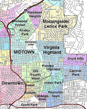
Poncey–Highland is an intown neighborhood on the east side of Atlanta, Georgia, located south of Virginia–Highland. It is so named because it is near the intersection of east/west Ponce de Leon Avenue and north/southwest North Highland Avenue. This Atlanta neighborhood was established between 1905 and 1930, and is bordered by Druid Hills and Candler Park across Moreland Avenue to the east, the Old Fourth Ward across the BeltLine Eastside Trail to the west, Inman Park across the eastern branch of Freedom Parkway to the south, and Virginia Highland to the north across Ponce de Leon Avenue. The Little Five Points area sits on the border of Poncey–Highland, Inman Park, and Candler Park.

<span class="mw-page-title-main">Sweet Auburn</span> United States historic place

The Sweet Auburn Historic District is a historic African-American neighborhood along and surrounding Auburn Avenue, east of downtown Atlanta, Georgia, United States. The name Sweet Auburn was coined by John Wesley Dobbs, referring to the "richest Negro street in the world," one of the largest concentrations of African-American businesses in the United States.

<span class="mw-page-title-main">Virginia–Highland</span> Neighborhoods of Atlanta in Fulton County, Georgia, United States

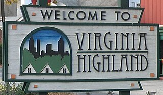
Virginia–Highland is an affluent neighborhood of Atlanta, Georgia, founded in the early 20th century as a streetcar suburb. It is named after the intersection of Virginia Avenue and North Highland Avenue, the heart of its trendy retail district at the center of the neighborhood. The neighborhood is famous for its bungalows and other historic houses from the 1910s to the 1930s. It has become a destination for people across Atlanta with its eclectic mix of restaurants, bars, and shops as well as for the Summerfest festival, annual Tour of Homes and other events.

From its incorporation in 1847, the municipal boundaries of Atlanta, Georgia, United States, were extended repeatedly from a small area around its railroad station to today's city covering 131.7 square miles (341 km2).

<span class="mw-page-title-main">Reynoldstown, Atlanta</span> United States historic place

Reynoldstown is a historic district and intown neighborhood on the near east side of Atlanta, Georgia, located two miles from downtown. The neighborhood is gentrifying and attracting new families, empty-nesters, Atlantans opposed to long commutes; as well as diverse culture of first-time homebuyers, single professionals, artist and students due to its close proximity to other nearby intown neighborhoods, high walkability index, urban amenities and nearby bohemian hotspots on Carroll Street in the adjoined-at-the-hip also historic Cabbagetown neighborhood and in other surrounding communities.

<span class="mw-page-title-main">Great Atlanta fire of 1917</span> 1917 fire which destroyed large parts of downtown Atlanta, Georgia, USA

The Great Atlanta Fire of 1917 began just after noon on 21 May 1917 in the Old Fourth Ward of Atlanta, Georgia. It is unclear just how the fire started, but it was fueled by hot temperatures and strong winds which propelled the fire. The fire, which burned for nearly 10 hours, destroyed 300 acres (120 ha) and 1,900 structures displacing over 10,000 people. Damages were estimated at $5 million,.

<span class="mw-page-title-main">Freedom Park (Atlanta, Georgia)</span>

Freedom Park is one of the largest city parks in Atlanta, Georgia, United States. The park forms a cross shape with the axes crossing at the Carter Center. The park stretches west-east from Parkway Drive, just west of Boulevard, to the intersection with the north-south BeltLine Eastside Trail, to Candler Park, and north-south from Ponce de Leon Avenue to the Inman Park/Reynoldstown MARTA station.

<span class="mw-page-title-main">Ponce de Leon Avenue</span> Road in Georgia, USA

Ponce de Leon Avenue, often simply called Ponce, provides a link between Atlanta, Decatur, Clarkston, and Stone Mountain, Georgia. It was named for Ponce de Leon Springs, in turn from explorer Juan Ponce de León, but is not pronounced as in Spanish. Several grand and historic buildings are located on the avenue.

<span class="mw-page-title-main">North Avenue (Atlanta)</span>

North Avenue is a major avenue in Atlanta, Georgia that divides Downtown Atlanta from Midtown Atlanta. North Avenue stretches continuously in Atlanta from Candler Park in the east, across Interstate 75 & Interstate 85, along the southern boundary of the Georgia Institute of Technology, to Joseph E. Lowery Boulevard just southwest of Georgia Tech, where it ends. North Avenue passes through the neighborhoods of Poncey-Highland, Old Fourth Ward, and Midtown Atlanta.

<span class="mw-page-title-main">Streetcars in Atlanta</span> Aspect of the history of Atlanta, Georgia, USA

Streetcars originally operated in Atlanta downtown and into the surrounding areas from 1871 until the final line's closure in 1949.

<span class="mw-page-title-main">Highland Avenue (Atlanta)</span>

Highland Avenue, east of the BeltLine North Highland Avenue, is a major thoroughfare in northeast Atlanta, forming a major business corridor connecting five Intown neighborhoods:

<span class="mw-page-title-main">Eastside, Atlanta</span> City district of Atlanta, Georgia

Eastside refers to the city district comprising the easternmost portion of Atlanta, Georgia, United States. The Eastside generally encompasses the area bounded on the west by Midtown Atlanta and Downtown Atlanta and on the east by the city limits. The central corridor of the district is the BeltLine Eastside Trail, which connects northern Eastside neighborhoods with those to the south. The Eastside is known for its nightlife establishments, craftsman architecture, local eateries, and quirky public art.

<span class="mw-page-title-main">Piedmont Avenue (Atlanta)</span> Street in Atlanta, Georgia, United States

Piedmont Avenue is a major thoroughfare in Atlanta, beginning in Downtown Atlanta and ending at its continuation as Piedmont Road just before crossing under Interstate 85. Along the way, Piedmont Avenue passes through Midtown Atlanta where several historic properties are located on the street.

<span class="mw-page-title-main">Edgewood Avenue</span> Street in Atlanta, Georgia, United States

Edgewood Avenue is a street in Atlanta, Georgia, United States which runs from Five Points in Downtown Atlanta, eastward through the Old Fourth Ward. The avenue runs in the direction of the Edgewood neighborhood, and stops just short of it in Inman Park. Edgewood Avenue was first important as the route of a streetcar line to Inman Park, Atlanta's first garden suburb and home to many of its most prominent citizens. Today, the avenue is known for its restaurants and nightlife around its intersection with Boulevard.

<span class="mw-page-title-main">Timeline of the BeltLine</span>

This is the timeline of the development of the BeltLine, a ring of trails and parks around central Atlanta.

References

  1. "Developers break ground on yet another project near Historic Fourth Ward Park," Creative Loafing, Oct. 4, 2012
  2. 1 2 Severance, Margaret (1895). Official guide to Atlanta: including information of the Cotton States and International Exposition. Atlanta: Foote & Davies Co. p. 42. Retrieved January 2, 2011.
  3. "Seven Prong Plan Unveiled For Boulevard", East Atlanta Patch, January 13, 2011
  4. Sams, Douglas. "Restaurants blossoming in Old Fourth Ward". Atlanta Business Chronicle (April 19, 2010). Retrieved January 9, 2011.
  5. "Hanleiter's Directory Map of Atlanta, 1870". Libs.uga.edu. Retrieved April 16, 2018.
  6. Henry, Scott (May 19, 2009). "Down on Boulevard: Positive change might finally come to Atlanta's lawless street". Creative Loafing (Atlanta) . Archived from the original on May 23, 2009. Retrieved June 6, 2009.
  7. 2010 U.S. census figures as tabulated by WalkScore
  8. "Census tract references map for Fulton County, Georgia. US Census Bureau" (PDF). 2.census.gov. Retrieved April 16, 2018.
  9. Smith, Charles Spencer; Payne, Daniel Alexander (April 16, 2018). "A History of the African Methodist Episcopal Church: Being a Volume Supplemental to a History of the African Methodist Episcopal Church". London, Johnson Reprint. Retrieved April 16, 2018 via Google Books.
  10. Mason, Herman Jr. (November 1, 1997). Black Atlanta in the Roaring Twenties. Arcadia Publishing. ISBN   9780738567105 . Retrieved April 16, 2018 via Google Books.
  11. "Map of Atlanta: Negro Residential Areas 1951, 1957, 1963 :: Planning Atlanta - A New City in the Making 1930s - 1990s - City Planning Maps". digitalcollections.library.gsu.edu. Retrieved April 16, 2018.
  12. Keating, Larry (2001). Atlanta: Race, Class and Urban Expansion. Temple University. p. 106. ISBN   1-56639-820-7.
  13. Trubey, Scott. "Westside park could have potential of Historic Fourth Ward Park". The Atlanta Journal-Constitution. Retrieved August 17, 2017.
  14. Development, Georgia Department of Economic (February 11, 2018). "Atlanta's Best Neighborhoods for Colorful Street Art". Official website of the Georgia Department of Economic Development. Retrieved February 11, 2018.
  15. "New website provides street art map to murals all over Atlanta". accessatlanta. Archived from the original on January 15, 2018. Retrieved February 11, 2018.
  16. Bostock, Cliff (August 29 – September 4, 2013). "Grazing on Edgewood Avenue". Creative Loafing. 42 (18).
  17. "Jackson Street Bridge - Engagement Photos in Atlanta".
  18. "Atlanta's bike share program begins Thursday". Commuting.blog.ajc.com. Retrieved April 16, 2018.

Old Fourth Ward organizations

About the Old Fourth Ward