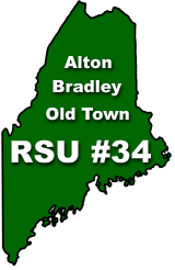
Old Town High School is a public high school in Old Town, Maine. It also serves the nearby towns of Alton and Bradley. It is part of RSU 34. OTHS sports teams are known as the Coyotes. [1]
Old Town High School is a public high school in Old Town, Maine. It also serves the nearby towns of Alton and Bradley. It is part of RSU 34. OTHS sports teams are known as the Coyotes. [1]

Susan Moore is a town in Blount County, Alabama, United States. At the 2020 census, the population was 787. It is one of two towns in Alabama to have the first and last name of an individual; the other is Phil Campbell.

Livermore is a town in Androscoggin County, Maine, United States. Formerly in Oxford County, Maine. The population was 2,127 at the 2020 United States Census. It is included in both the Lewiston-Auburn, Maine Metropolitan Statistical Area and the Lewiston-Auburn, Maine Metropolitan New England City and Town Area. High schools students from Livermore attend Spruce Mountain High School in neighboring Livermore Falls. Livermore is known for The Norlands, the Washburn family home.

Minot is a town in Androscoggin County, Maine, United States. The population was 2,766 at the 2020 census. The town includes the villages of West Minot and Minot Center. It is part of both the Lewiston-Auburn, Maine metropolitan statistical area and the Lewiston-Auburn, Maine metropolitan New England city and town area.
Ashland is a town in Aroostook County, Maine, United States. The population was 1,202 at the 2020 census.

Oakfield is a town in Aroostook County, Maine, United States. The population was 661 at the 2020 census. The village of Oakfield, listed as a census-designated place, is in the northwestern corner of the town.

Southwest Harbor is a town in Hancock County, Maine, United States. Located on Mount Desert Island, the population was 1,756 at the 2020 census. The municipality contains within it the villages of Southwest Harbor, Manset, Seawall, Wonderland, and Pemetic Hills.
Sullivan is a town in Hancock County, Maine, United States. The population was 1,219 at the 2020 census. The town was named for Daniel Sullivan, an early settler. Colloquially referred to as "Sully" or "the Sullivans"—like many Maine municipalities composed of villages with geographic designations of the town proper—the municipality was incorporated in 1789. Located in the Upper Schoodic Peninsula sub-region of Maine's Downeast Acadia region, the municipality has been known as "Waukeag", "New Bristol", and later Sullivan; and once included the nearby communities of Hancock, Sorrento, and what would later be Township 7, South & Middle Districts. Once home to abundant granite quarries, the town of Sullivan is now a residential community for nearby Ellsworth and Mount Desert Island. Located along U.S. Route 1, the Taunton River, and Hog Bay, Sullivan is home to a reversing tidal falls and many scenic turnouts that dot the Schoodic National Scenic Byway along the Upper Schoodic Peninsula.

Union is a town in Knox County, Maine, United States. The population was 2,383 at the 2020 census. It is home to the Matthews Museum of Maine Heritage and annual Union Fair.
Hermon is a town in Penobscot County, Maine, United States. The population was 6,461 at the 2020 census.
Kenduskeag is a town in Penobscot County, Maine, United States. The population was 1,346 at the 2020 census.

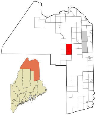
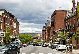
Old Town is a city in Penobscot County, Maine, United States. The population was 7,431 at the 2020 census. The city's developed area is chiefly located on the relatively large Marsh Island, but its boundaries extend beyond it. The island is surrounded and defined by the Penobscot River to the east and the Stillwater River to the west.

Veazie is a town in Penobscot County, Maine, United States. The population was 1,814 at the 2020 census. The town is named after General Samuel Veazie, an early lumber baron and railroad operator. Veazie was originally part of Bangor, using Penobscot River water power to operate sawmills. It became a separate town in 1853 because Gen. Veazie, its wealthiest citizen, thought Bangor's property taxes were too high.

Bath is a city in Sagadahoc County, Maine, United States. The population was 8,766 at the 2020 census. It is the county seat of Sagadahoc County, which includes one city and 10 towns. The city is popular with tourists, many drawn by its 19th-century architecture. It is home to the Bath Iron Works and Heritage Days Festival, held annually on the Fourth of July weekend. It is commonly known as "The City of Ships" because of all the sailing ships that were built in the Bath shipyards. Bath is part of the metropolitan statistical area of Greater Portland.
Belfast is a city in Waldo County, Maine, United States. As of the 2020 census, the city population was 6,938. Located at the mouth of the Passagassawakeag River estuary on Belfast Bay and Penobscot Bay. Belfast is the county seat of Waldo County. Its seaport has a wealth of antique architecture in several historic districts, and remains popular with tourists.

Arundel is a town in York County, Maine, United States. At the 2020 census, the population was 4,264. It is part of the Portland–South Portland–Biddeford, Maine Metropolitan Statistical Area. The Municipality of Arundel includes the constituent communities and neighbourhoods of: Arundel Village, Vinegar Hill, Riverside Arundel, Log Cabin Crossing, Goff Mill, Millers Crossing, and Cottagehill, among other neighbourhoods in an inland area adjacent to the Towns of Kennebunkport and Biddeford. In 2014, Arundel was named “Best Place to Live in Maine” by Downeast Magazine.
A regional school unit is a type of school district in Maine.

Livermore Falls is a town in Androscoggin County, Maine, United States. The population was 3,060 at the 2020 census. It is included in both the Lewiston-Auburn, Maine Metropolitan Statistical Area and the Lewiston-Auburn, Maine Metropolitan New England City and Town Area. High school students in Livermore Falls attend Spruce Mountain High School.
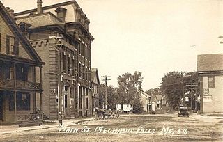
Mechanic Falls is a town in Androscoggin County, Maine, United States. The population was 3,107 at the 2020 census. It is included in both the Lewiston-Auburn, Maine metropolitan statistical area and the Lewiston-Auburn, Maine metropolitan New England city and town area.
Bucksport High School is a public high school in Bucksport, Maine, United States. It is part of Regional School Unit (RSU) 25. Between 350 and 400 students study at Bucksport High School. It also provides a satellite program on campus for Hancock County Technical Center.
Skowhegan Area High School is a public high school in Skowhegan, Maine, United States. It is part of Maine School Administrative District 54 which includes the towns of Skowhegan, Canaan, Mercer, Smithfield, Cornville, and Norridgewock.
44°56′06″N68°39′26″W / 44.9351°N 68.6572°W
| | This Maine school-related article is a stub. You can help Wikipedia by expanding it. |