Ordubad

Last updated
Ordubad
City and municipality
Collage of Ordubad.png
Landmarks of Ordubad, from top left:
Panorama view of Ordubad and mountain range area • Juma Mosque
Huseyinuh Mosque • Dirnis Mosque
Geysarriya Monument • Ambaras Mosque
Sarshahar Mosque
Azerbaijan adm location map.svg
Red pog.svg
Ordubad
Coordinates: 38°54′29″N46°01′40″E / 38.90806°N 46.02778°E / 38.90806; 46.02778
CountryFlag of Azerbaijan.svg  Azerbaijan
Autonomous republic Nakhchivan Autonomous Republic
District Ordubad
Population
  Total10,372
Time zone UTC+4 (AZT [1] )
Postal code
AZ6900
Area code +994 036

Ordubad is the second largest city of Azerbaijan's Nakhchivan Autonomous Republic and the capital of an eponymous district. Ordubad is a medieval city of the Caucasus and in its current capacity of a town was founded in the 18th century. The town is divided into five districts: Ambaras, Kurdtatal, Mingis, Sarshahar, and Uch.

Contents

Ordubad is well known for its exports of fruits and spices, and for its cuisine.

Etymology

Ordubad is a name of Turko-Persian origin and means "army town", from Turkic ordu ("army") and Persian bad ("town"), which implies that the city was founded during the period of the Mongol or the ensuing Il-Khanid rule. [2] The historian and geographer Hamdallah Mustawfi (1281–1349) mentions Ordubad in the mid-14th century as "a provincial town, one of the five towns making up the tumān of Nakhchivan, with fine gardens, and producing good grapes, corn and cotton". [2]

French traveller Jean Saint-Martin mentions, in his 1818 book about the geography of Armenia, that the contemporary people referred to the city as Ordouvar (Armenian : Որդուվար) or Ourdovar (Armenian : Ուրդովար) in Armenian, and Ardoubad in Turkish and Persian, and that the settlement had already existed in the 14th century. [3]

Location

Ordubad city is located at an elevation of 949 metres (3,114 ft). It is on the northern bank of the central stretch of the Aras River. The river that rises from the north from the Mt. Qobān (also known as Qapïjïq in Turkish and Kapudzhukh or Kapydzhik in Russian) at an elevation of 3,904 metres (12,808 ft) drains into the Araxes. [2] The town is divided into five districts of the Ambaras, the Kurdtatal, the Mingis, the Sar sheher, and the Uch. [4] The city has a large number of walnut and mulberry trees. [5] The closest railway station is Ordubad and the distance to Nakhchivan city is 88 kilometres (55 mi). Tabriz is 94 kilometres (58 mi) away to the north-northwest. [2]

Both the absolute minimum temperature (−33 °C or −27.4 °F) and the absolute maximum temperature (46 °C or 114.8 °F) were observed in Ordubad (and also in Julfa). [6]

Demographics

The ethnic composition of Ordubad
Ethnic group1875 census [7] 1897 census [8] [9] 1916 almanac [10] 1989 census [11] 1991 census [12] 2008 census
Tatars (later known as Azerbaijanis)4,7004,0885,449
Armenians 300284179
Russians 17986
Others603
TOTAL5,0004,6115,7179,3959,50010,372

History

Sersehir Mosque Sersehir2.jpg
Sersehir Mosque

The city may have been established by the 14th century, or earlier. [3] The Ottoman Empire (1299–1923) had occupied the Ordubad territory in the past. Before this occupation, a local rebellion had been organized against invasion of the Ottomans by Hadji, known as “Kasab” (butcher) and Bayandar when they learned that the Saffavids intended to attack. They were backed by the local people. The rebels initially took control of the city and also occupied a fortress near the city. However, the rebels had their own internal dissensions, and as a result a small battalion of the Ottoman army defeated the rebels and killed them. Following this victory and occupation by the Ottomans,Khaten bey Ordubadi ,the prime vizier, appealed to the Shah to waive off all taxes levied on the local people, which was agreed. [13]

Ordubad was once an important regional stop on the caravan route of the Silk Road trade with China, Europe and India. The city was first founded as Gala city, a feudal city, on the top of the Ambras on the left bank of Ordubadchay  [ az ] river in the 15th century. In view of extensive trade, the city started developing on the right bank of the Ordubadchay with many new districts. In the 17th and 18th centuries trade centres were established in the city on the right bank, which diminished the importance of Gala city. Built in the backdrop of Zangezur Caucasus mountain it is enclosed on three sides by mountains providing for a very green environment. In the 17th century the city underwent major reconstruction activity, maintaining eastern feudal architectural features. [4] Following the Russo-Persian War (1826-1828), the town passed from Iranian rule to Imperial Russian rule under the Treaty of Turkmenchay of 1828. According to a census conducted in 1834, Ordubad, with its 52 villages, had a population of 11,341 consisting of Muslims and Armenians. [2] From 1849–1868, the city was the center of the Ordubad uezd.

The Ordubad site was added to the UNESCO World Heritage Tentative List on 24 October 2001 in the Cultural category under Criteria (i), (iv) and (v). [4]

Archaeological excavations

Archaeological excavations carried out by Russian archaeologists in ancient settlements of Ordubad have unearthed remnants of Bronze Age dated to the fourth century. [14] It includes a necropolis, which revealed graves of warriors also dated to the fourth century. These were initially assessed, in 1928, as skeletons of only warrior men but subsequent research carried out by the Archaeological and Ethnological Institute of Azerbaijan National Academy of Science in 2004 has concluded that at least one of the skeletons is of a woman warrior found with her armory such as quiver, arrows and helmet. [14]

Economy

Ordubad's economy is dependent on trade, particularly of fruits, wheat, and silk; grapes are of 40 varieties. The silk exports have been mostly to Venice, Marseille, Amsterdam and many other places in Europe, from the middle of the 16th century. During the early years of the 20th century, Ordubad silk received 13 gold medals in international exhibitions and fairs. [15] [16] Arak is also an export commodity of the city. [5] Economic activity in Ordubad and nearby regions includes copper mining, Paragachayskoe molybdenum deposit from the Meghri-Ordubad gratoidnym batholiths, bauxite, tungsten and tin ore. [17]

Industry

21 industrial plants operated in the region in 2015. The average number of people working for industry is 634. The cost of industrial products was 8469,7 thousand manat in 2015. Its rate is 4.8 times more than the level in 2005. There are 9 milk processing plants in Ordubad. The daily production rate is 24 ton. Besides, the wine plant ''Oren-Gala" produces pomegranate juice.

Features of the city

A view of Ordubad Ordubad 2014-02-11 23-35.jpg
A view of Ordubad

In the new city of Ordubad, planned in the 17th century, there were five divisions or districts with trade squares of larger size than the earlier blocks, which also had a plethora of mosques, springs, and bath-houses. The medieval market square in the heart of the city is prominent and the glass mosque, the Juma Mosque, is a landmark. Caravan sheds and the market here traded in silk and dry fruits with East European countries. The lay out of the streets is radial and appears in the shape of a fan close to the center of the city. Each of the streets have squares which are a typical feature of the city. [4] A well known suburb of the city is Akulis through which a small stream flows. The city has many private and public schools. [5] The city has a number qanats or underground canals called "kahriz", which are the source of water for houses and orchards. [18] The city reflects tradition and culture of northern and southern Azerbaijan. [16]

Museums

There are three museums in Ordubad.

Juma Mosque

Juma Mosque, in the heart of the city, was initially built as the office of Hatambek Ordubadi vizier of Shah Abbas, in the 17th century. Even now it looks more like a palace. The history museum, located on the opposite side, is a domed structure that is dated to the 18th century which in the past was used as a silk shop, restaurant and zurkhaneh ("house of strength"). Soviet era photos are exhibited here. The porch here was once decorated with statues of Russian communists and the roof was also designed in Russian architecture, and these have since been removed. [20]

Qeyyseriye

Geysariyye Monument at night Geysarriya at night.jpg
Geysariyye Monument at night

Geysariyye Monument is a historic edifice dated to the 17th century, located in the main market centre. It is now a historical and ethnography museum. [15]

Gemigaya Mountain

Gemigaya Mountain is an important backdrop to the city which is known for its petroglyphs, necropolises, and ancient settlements of Ordubad, Sabirkend, Plovdagh and Kharaba Gilan, which attests to its occupancy between 7th to 1st century BC. [15] It is situated within the Ordubad National Park. [18]

Observatory

In the Astronomical Observatory at Ordubad, Nakhchivan ASSR and also at the Tarija, Bolivia, with the help of expedition astrograph, 6,000 plates were recorded from 1983–1988 which cataloged 200,000 stars south of the equator up to the 11th magnitude. [21]

Notable natives

Related Research Articles

<span class="mw-page-title-main">Nakhchivan Autonomous Republic</span> Exclave of Azerbaijan

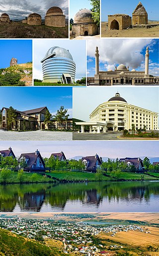
The Nakhchivan Autonomous Republic is a landlocked exclave of the Republic of Azerbaijan. The region covers 5,502.75 km2 (2,124.62 sq mi) with a population of 459,600. It is bordered by Armenia to the east and north, Iran to the southwest, and Turkey to the west. It is the sole autonomous republic of Azerbaijan, governed by its own elected legislature.

<span class="mw-page-title-main">Treaty of Turkmenchay</span> Agreement between Qajar Iran and Imperial Russia that concluded the Russo-Persian War of 1826–28

The Treaty of Turkmenchay was an agreement between Qajar Iran and the Russian Empire, which concluded the Russo-Persian War (1826–1828). It was second of the series of treaties signed between Qajar Iran and Imperial Russia that forced Persia to cede or recognize Russian influence over the territories that formerly were part of Iran.

<span class="mw-page-title-main">Nakhchivan (city)</span> Capital of Nakhchivan, Azerbaijan

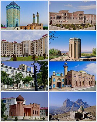
Nakhchivan is the capital and largest city of the eponymous Nakhchivan Autonomous Republic, a true exclave of Azerbaijan, located 450 km (280 mi) west of Baku. The municipality of Nakhchivan consists of the city of Nakhchivan, the settlement of Əliabad and the villages of Başbaşı, Bulqan, Haciniyyət, Qaraçuq, Qaraxanbəyli, Tumbul, Qarağalıq, and Daşduz. It is spread over the foothills of Zangezur Mountains, on the right bank of the Nakhchivan River at an altitude of 873 m (2,864 ft) above sea level.

<span class="mw-page-title-main">Ordubad District</span> District of Nakhchivan Autonomous Republic in Azerbaijan

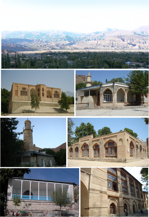
Ordubad District is one of the 7 districts of the Nakhchivan Autonomous Republic of Azerbaijan. The district borders the district of Julfa, as well as the Syunik Province of Armenia, and the East Azerbaijan Province of Iran. Its capital and largest city is Ordubad. As at 2020, the district had a population of 50,200.

<span class="mw-page-title-main">Shamakhi</span> City in Azerbaijan

Shamakhi is a city in Azerbaijan and the administrative centre of the Shamakhi District. The city's estimated population as of 2010 was 31,704. It is famous for its traditional dancers, the Shamakhi Dancers, and also for perhaps giving its name to the Soumak rugs.

<span class="mw-page-title-main">Merzifon</span> Municipality in Amasya, Turkey

Merzifon is a town in Amasya Province in the central Black Sea region of Turkey. It is the seat of Merzifon District. Its population is 61,376 (2021). The mayor is Alp Kargı (CHP).

Julfa, formerly Jugha, is a city and the capital of the Julfa District of the Nakhchivan Autonomous Republic of Azerbaijan.

<span class="mw-page-title-main">Blue Mosque, Yerevan</span> 18th century Persian mosque in Yerevan

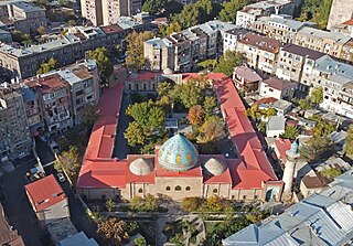
The Blue Mosque is an 18th-century Shia mosque in Yerevan, Armenia. It was commissioned by Hoseyn Ali Khan, the khan of the Iranian Erivan Khanate. It is one of the oldest extant structures in central Yerevan and the most significant structure from the city's Iranian period. It was the largest of the eight mosques of Yerevan in the 19th century and is the only active mosque in Armenia today.

<span class="mw-page-title-main">Erivan Governorate</span> Territory of the Russian Empire from 1849 to 1917; now part of Armenia

The Erivan Governorate was a province (guberniya) of the Caucasus Viceroyalty of the Russian Empire, with its centеr in Erivan. Its area was 27,830 sq. kilometеrs, roughly corresponding to what is now most of central Armenia, the Iğdır Province of Turkey, and the Nakhchivan exclave of Azerbaijan. At the end of the 19th century, it bordered the Tiflis Governorate to the north, the Elizavetpol Governorate to the east, the Kars Oblast to the west, and Persia and the Ottoman Empire to the south. Mount Ararat and the fertile Ararat Valley were included in the center of the province.

<span class="mw-page-title-main">Mammed Said Ordubadi</span> Azerbaijani writer

Mammad Said Ordubadi was Azerbaijani writer, poet, playwright and journalist.

Armenians in Azerbaijan are the Armenians who lived in great numbers in the modern state of Azerbaijan and its precursor, Soviet Azerbaijan. According to the statistics, about 500,000 Armenians lived in Soviet Azerbaijan prior to the outbreak of the First Nagorno-Karabakh War in 1988. Most of the Armenian-Azerbaijanis however had to flee the republic, like Azerbaijanis in Armenia, in the events leading up to the First Nagorno-Karabakh War, a result of the ongoing Armenian-Azerbaijani conflict. Atrocities directed against the Armenian population took place in Sumgait, Ganja and Baku. Today the vast majority of Armenians in Azerbaijan live in territory controlled by the break-away region Nagorno-Karabakh which declared its unilateral act of independence in 1991 under the name Nagorno-Karabakh Republic but has not been recognised by any country, including Armenia.

Azadkənd is a village and municipality in the Ordubad District of Nakhchivan, Azerbaijan. It is located in the left side of the Ordubad-Nakhchivan highway, 20 km in the south-west from the district center, on the right bank of the Gilanchay River. Its population is busy with gardening, vegetable-growing, farming, vine-growing, poultry farming and animal husbandry. There are secondary school, club, hospital and kindergarten in the village. It has a population of 1,054.

<span class="mw-page-title-main">Aşağı Əylis</span> Municipality in Nakhchivan, Azerbaijan

Aşağı Əylis or Agulis is a village and municipality in the Ordubad District of Nakhchivan, Azerbaijan. It is located in the near the Ordubad-Yuxarı Aylis highway, 3 km in the east from the district center, on the bank of the Aylis River. Its population is busy with gardening, farming, animal husbandry. There are secondary school, club and a medical center in the village. It has a population of 1007.

Vənənd is a village and municipality in the Ordubad District of Nakhchivan, Azerbaijan. It is located in the near of the Ordubad-Unus highway, 17 km in the north-west from the district center, on the bank of the Vanandchay river. People of the village is busy with gardening, grain growing, cotton-growing, animal husbandry. There are secondary school, music school, library, culture house, a medical center and kindergarten in the village. It has a population of 2,347. The municipality consists of the villages of Vənənd and Xanağa.

<span class="mw-page-title-main">Yuxarı Əylis</span> Village and municipality in Ordubad, Nakhchivan, Azerbaijan

Yuxarı Əylis is a village and municipality in the Ordubad District of Nakhchivan, Azerbaijan. It is located in the left and right sides of the Ordubad-Aylis highway, 12 km in the north-east from the district center. Its population is busy with gardening, farming, animal husbandry. There are secondary school, club, library, communication branch and a medical center in the village. It has a population of 1,916.

Dırnıs is a village and municipality in the Ordubad District of Nakhchivan, Azerbaijan. It is located in the near of the Ordubad-Unus highway, 29 km in the north-east from the district center, on the bank of the Venend River. Its population is busy with gardening, vegetable-growing and farming. There is a secondary school, club, library, culture house, medical center and the mosque of the Middle Ages in the village. It has a population of 1,470. In the territory of the village, in the cemetery were medieval a stone ram statues on the graves.

Bist is a village and municipality in the Ordubad District of Nakhchivan, Azerbaijan. It is located in the near of the Ordubad-Nurgut highway, in the north-west from the district center. Its population is busy with gardening, beekeeping and animal husbandry. There are secondary school, club, library and a medical center in the village. It has a population of 483.

Darkənd is a village and municipality in the Ordubad District of Nakhchivan, Azerbaijan. It is located in the south of the Ordubad-Nakhchivan highway, 15 km in the south-west from the district center, on the right bank of the Gilanchay River. Its population is busy with gardening, vegetable-growing, animal husbandry. There are secondary school and a medical center in the village. It has a population of 500. The ruins of the historical and architectural monuments is in the territory of the village. The tomb, the mosque's minaret, etc. is attracting attention.

<span class="mw-page-title-main">Armenians in Nakhchivan</span> Ethnic group in Azerbaijan

Armenians had a historic presence in Nakhchivan. According to an Armenian tradition, Nakhchivan was founded by Noah, of the Abrahamic religions. During the Soviet era, Nakhchivan saw a significant demographic shift. The Armenian population saw a great reduction in their numbers throughout the years repatriating to Armenia. Nakhchivan's Armenian population gradually decreased to around 0%. Still some Armenian political groupings of Armenia and the Armenian diaspora, claim that Nakhchivan should belong to Armenia. The Medieval Armenian cemetery of Jugha (Julfa) in Nakhchivan, regarded by Armenians as the biggest and most precious repository of medieval headstones marked with Christian crosses – khachkars, was completely demolished by 2006.

<span class="mw-page-title-main">Agulis massacre</span> Massacre event

The Agulis massacre was a massacre of the Armenian population of Agulis by Azerbaijani state authorities and Azeri locals from Ordubad and refugees from Zangezur as part of the Muslim uprisings in Kars and Sharur–Nakhichevan against the First Republic of Armenia. The attack, lasting from December 24 to December 25, 1919, resulted in the destruction of the town of Agulis.

References

  1. "Azerbaijan cancels daylight saving time - UPDATE". Azernews.Az. March 17, 2016.
  2. 1 2 3 4 5 "Ordubād". Encyclopaedia Iranica. Retrieved 21 November 2015.
  3. 1 2 Saint-Martin, Jean (1818). Mémoires historiques et géographiques sur l'Arménie. Paris: L'imprimerie Royale. p. 134. Original text in French: "Որդուվար Ortouvar, ou Ուրդովար Ourtovar, en turc et en persan Ardoubad, grand bourg à l'extrémité orientale du pays de Koghthen, au nord de l'Araxes, sur une petite rivière qui vient des montagnes de Gaban et se jette dans ce fleuve. Ce bourg existoit déjà au quatorzième siècle."; English translation: "Որդուվար Ortouvar, ou Ուրդովար Ourtovar, in Turkish and Persian Ardoubad, big town at the eastern extremity of the country of Koghthen, in the north of the Araxes, on a little river that comes from the mountains of Gaban and that empties in this river. This town existed already in the fourteenth century."
  4. 1 2 3 4 "Ordubad historical and architectural reserve". UNESCO Organization. Retrieved 19 November 2015.
  5. 1 2 3 Sayyāḥ 1999, p. 281.
  6. Mahmudov, Rza. "Water Resources of the Azerbaijan Republic". Ministry of Ecology and Natural Resources of Azerbaijan Republic. Archived from the original on 24 May 2007. Retrieved 27 November 2016.
  7. Сборник сведений о Кавказе, том III, с. 274
  8. Первая Всеобщая перепись населения Российской империи 1897 г.. 71. Эриванская губерния via www.prlib.ru.
  9. "Демоскоп Weekly - Приложение. Справочник статистических показателей". www.demoscope.ru.
  10. Кавказский календарь на 1917 год [Caucasian calendar for 1917] (in Russian) (72nd ed.). Tiflis: Tipografiya kantselyarii Ye.I.V. na Kavkaze, kazenny dom. 1917. pp. 214–221. Archived from the original on 4 November 2021.
  11. "Демоскоп Weekly - Приложение. Справочник статистических показателей". www.demoscope.ru.
  12. "Ордубад". Большой Энциклопедический словарь. 2000.
  13. Zardabli 2014, p. 318.
  14. 1 2 Mayor 2014, p. 73.
  15. 1 2 3 "Ordubad: an ancient city in the heart of Eurasia". Foreign Policy News. 17 October 2014. Retrieved 19 November 2015.
  16. 1 2 Rustamkhanli 2013, p. 175.
  17. Publications 2007, p. 73.
  18. 1 2 "Introducing Ordubad". Lonely Planet. Retrieved 21 November 2015.
  19. "Ordubad History Museum" . Retrieved 1 June 2017.
  20. Noble, Kohn & Systermans 2008, p. 293-94.
  21. McNally 2012, p. 232.
  22. Ибрагимов Исмаил Али оглы (in Russian). Heroes of the country.
  23. "Ордубады Мамед Саид". Great Soviet Encyclopedia.
  24. "Рафиев Наджафкули Раджабали оглы". Heroes of the country.
  25. "Rizayev Novruz Kerim oglu". Minister of National Security Azerbaijan Republic. Archived from the original on 2010-11-26.
  26. "Чероков Виктор Сергеевич". Great Soviet Encyclopedia.
  27. "член-корреспондент Юсиф Гейдарович Мамедалиев". Faculty of Chemistry, Moscow State University.
  28. "Former Azerbaijani Ambassador to Iran Nominated for Presidential Post". en.trend.az. 26 August 2008.

Bibliography