Nevada is a city in and the county seat of Vernon County, Missouri, United States. The population was 8,386 at the 2010 census, and 8,254 in the 2018 estimate. The local government has a council-manager model.

Starved Rock State Park is a state park in the U.S. state of Illinois, characterized by the many canyons within its 2,630 acres (1,064 ha). Located just southeast of the village of Utica, in Deer Park Township, LaSalle County, Illinois, along the south bank of the Illinois River, the park hosts over two million visitors annually, the most for any Illinois state park.

The Santa Fe Trail was a 19th-century route through central North America that connected Franklin, Missouri, with Santa Fe, New Mexico. Pioneered in 1821 by William Becknell, who departed from the Boonslick region along the Missouri River, the trail served as a vital commercial highway until 1880, when the railroad arrived in Santa Fe. Santa Fe was near the end of El Camino Real de Tierra Adentro which carried trade from Mexico City. The trail was later incorporated into parts of the National Old Trails Road and U.S. Route 66.

Etowah Indian Mounds (9BR1) are a 54-acre (220,000 m2) archaeological site in Bartow County, Georgia, south of Cartersville. Built and occupied in three phases, from 1000–1550 CE, the prehistoric site is located on the north shore of the Etowah River.

The Osage Nation is a Midwestern Native American tribe of the Great Plains. The tribe developed in the Ohio and Mississippi river valleys around 700 BC along with other groups of its language family. They migrated west after the 17th century, settling near the confluence of the Missouri and Mississippi rivers, as a result of Iroquois invading the Ohio Valley in a search for new hunting grounds.

The Quapaw people are a tribe of Native Americans that coalesced in what is known as the Midwest and Ohio Valley of the present-day United States. The Dhegiha Siouan-speaking tribe historically migrated from the Ohio Valley area to the west side of the Mississippi River in what is now the state of Arkansas; their name for themselves refers to this migration and to traveling downriver.

Fort Union Trading Post National Historic Site is a partial reconstruction of the most important fur trading post on the upper Missouri, 1829-1867. The fort site is about two miles from the confluence of the Missouri River and its tributary, the Yellowstone River, on the Dakota side of the North Dakota/Montana border, 25 miles from Williston, North Dakota.

Fort Gibson is a historic military site next to the modern city of Fort Gibson, in Muskogee County Oklahoma. It guarded the American frontier in Indian Territory from 1824 to 1888. When it was constructed, the fort was farther west than any other military post in the United States. It formed part of the north–south chain of forts that was intended to maintain peace on the frontier of the American West and to protect the southwestern border of the Louisiana Purchase. The fort succeeded in its peacekeeping mission for more than 50 years, as no massacres or battles occurred there.

Fort Osage was an early 19th-century factory trading post run by the United States Government in western Missouri on the American frontier; it was located in present-day Sibley, Missouri. The Treaty of Fort Clark, signed with certain members of the Osage Nation in 1808, called for the United States to establish Fort Osage as a trading post and to protect the Osage from tribal enemies.
Clark's Hill/Norton State Historic Site is located on the eastern edge of Jefferson City Missouri, United States. The park preserves one of the campsites used by the Lewis and Clark Expedition as well as a lookout point from which William Clark viewed the confluence of the Osage and Missouri rivers. American Indian burial mounds may also be seen at the site. The site was donated to the state by Jefferson City residents William and Carol Norton in 2002 and opened to the public in 2004.

Town Creek Indian Mound is a prehistoric Native American archaeological site located near present-day Mount Gilead, Montgomery County, North Carolina, in the United States. The site, whose main features are a platform mound with a surrounding village and wooden defensive palisade, was built by the Pee Dee, a South Appalachian Mississippian culture people that developed in the region as early as 980 CE. They thrived in the Pee Dee River region of North and South Carolina during the Pre-Columbian era. The Town Creek site was an important ceremonial site occupied from about 1150—1400 CE. It was abandoned for unknown reasons. It is the only ceremonial mound and village center of the Pee Dee located within North Carolina.

Mastodon State Historic Site is a publicly owned, 431-acre (174 ha) archaeological and paleontological site with recreational features in Imperial, Missouri, maintained by the Missouri Department of Natural Resources, preserving the Kimmswick Bone Bed. Bones of mastodons and other now-extinct animals were first found here in the early 19th century. The area gained fame as one of the most extensive Pleistocene ice age deposits in the country and attracted scientific interest worldwide.
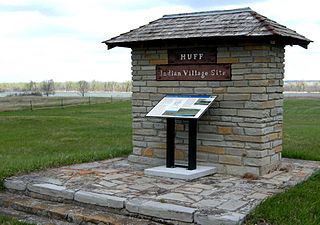
The Huff Archeological Site is a prehistoric Mandan village in North Dakota dated around 1450 AD. It was discovered in the early 1900s. The site has been designated a National Historic Landmark, and is one of the best preserved sites of the period.

The Pike-Pawnee Village Site, or Hill Farm Site, designated 25WT1 by archaeologists, is a site near the village of Guide Rock in Webster County, in the south central portion of the state of Nebraska, in the Great Plains region of the United States. It was the location of a village of the Kitkehahki band of the Pawnee people, in a region of the Republican River valley that they occupied intermittently from the 1770s to the 1820s.

Watkins Mill in Lawson, Missouri, United States, is a preserved woolen mill dating to the mid-19th century. The mill is protected as Watkins Woolen Mill State Historic Site, which preserve its machinery and business records in addition to the building itself. It was designated a National Historic Landmark and added to the National Register of Historic Places in 1966 in recognition for its remarkable state of preservation. The historic site is the centerpiece of Watkins Mill State Park, which is managed by the Missouri Department of Natural Resources.
The Iliniwek Village State Historic Site is a state-owned property in Clark County, Missouri, maintained by the Missouri Department of Natural Resources, preserving the only known Illinois Indian village discovered in Missouri.

Towosahgy State Historic Site (23MI2), also known as Beckwith's Fort Archeological Site, is a large Mississippian archaeological site with a Woodland period Baytown culture component located in Mississippi County, Missouri, United States. It is believed to have been inhabited from c. 400–1350 CE. The site is maintained by the Missouri Department of Natural Resources as a state historic site. The name Towosahgy is an Osage word which means "old town". It is not known if members of the historic Osage people, who dominated a large area of present-day Missouri at the beginning of the 19th century, ever occupied the site. The site was acquired by the Missouri state park system in 1967 and added to the National Register of Historic Places in 1969 as NRIS number 69000113.

The Lynch Quarry site, also known as the Lynch Knife River Flint Quarry, and designated by the Smithsonian trinomial 32DU526, is a historic pre-Columbian flint quarry located near Dunn Center, North Dakota, United States. The site was a major source of flint found at archaeological sites across North America, and it has been estimated that the material was mined there from 11,000 B.C. to A.D. 1600. The site was designated a National Historic Landmark in 2011.
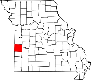
This is a list of the National Register of Historic Places listings in Vernon County, Missouri.
The Gumbo Point Site is a Native American archaeological site in Saline County, Missouri, located near the Missouri River north of the city of Malta Bend. The site was designated a National Historic Landmark in 1969.