Outline of the State of Palestine

Last updated

A map of the State of Palestine with the West Bank and Gaza Strip highlighted in red LocationPalestine.svg
A map of the State of Palestine with the West Bank and Gaza Strip highlighted in red
An enlargeable map of the West Bank Westbankjan06.jpg
An enlargeable map of the West Bank
An enlargeable map of the Gaza Strip Gaza Strip 2009 Jan 13.png
An enlargeable map of the Gaza Strip

The following outline is provided as an overview of and topical guide to the State of Palestine:

Contents

Palestine country in the Middle East, politically under the jurisdiction of the Palestinian government and the Hamas Government in Gaza. Since the Palestinian Declaration of Independence in 1988 and the consequent admission into UN as an observer state in 2012, Palestine is today recognized by three-quarters of the world's countries. [1] Its claimed capital is East Jerusalem, although Ramallah is its internationally recognised capital. Although recently promoted to a non-member state status in the UN, the State of Palestine does not exert full control of its territory and has historically turbulent relations with Israel and much of the west.

General reference

Geography of the State of Palestine

An enlargeable topographic map of Israel and the Palestine. Outlined in red are the 1949-designated boundaries of the West Bank and Gaza Strip Israel Topography.png
An enlargeable topographic map of Israel and the Palestine. Outlined in red are the 1949-designated boundaries of the West Bank and Gaza Strip
  • Total: 466 km (290 mi)
Flag of Israel.svg  Israel 358 km (222 mi)
Flag of Jordan.svg  Jordan 97 km (60 mi)
Flag of Egypt.svg  Egypt 11 km (6.8 mi)


Note: West Bank includes the northern portion of the Dead Sea with a 40 km (25 mi) shoreline.

Environment of Palestine

An enlargeable satellite image of State of Palestine, Israel and surrounding region Satellite image of Israel in January 2003.jpg
An enlargeable satellite image of State of Palestine, Israel and surrounding region
The Palestine sunbird, native to Palestine Palestine Sunbird standing on fence.jpg
The Palestine sunbird, native to Palestine
Inflorescence of the terebinth (Pistacia terebinthus), a tree native to Palestine Pistacia palaestina blossom1.JPG
Inflorescence of the terebinth (Pistacia terebinthus), a tree native to Palestine
The Dead Sea on a rough day, with salt deposits on cliffs DeadSea3667.jpg
The Dead Sea on a rough day, with salt deposits on cliffs
Colored postcard of the Jordan River by Karimeh Abbud circa 1925. Abbud24C.jpg
Colored postcard of the Jordan River by Karimeh Abbud circa 1925.

Natural geographic features of Palestine

Regions of Palestine

Regions of the State of Palestine

Ecoregions of Palestine

List of ecoregions in Palestine

Administrative divisions of Palestine

Administrative divisions of the State of Palestine

Demography of Palestine

Government and politics of Palestine

The building of the Palestinian Legislative Council in Ramallah Palaestinensischer Legislativrat.jpg
The building of the Palestinian Legislative Council in Ramallah
The souq in the Old City of Jerusalem, which both the Palestinians and Israelis proclaim as their capital OldCityJerusalem01 ST 06.JPG
The souq in the Old City of Jerusalem, which both the Palestinians and Israelis proclaim as their capital

Branches of the government of Palestine

Legislative branches of the government of Palestine

Judicial branch of the government of Palestine

  • According to the Constitution of Palestine, all courts relating to the country shall be independent.

Local governance in Palestine

Foreign relations of Palestine

Palestine and the United Nations

UN 1947 partition plan for Palestine UN Partition Plan For Palestine 1947.png
UN 1947 partition plan for Palestine

International organization membership

UN stamp commemorating the inalienable rights of the Palestinian people Un1981-343.jpg
UN stamp commemorating the inalienable rights of the Palestinian people

Palestine is a member in a number of international organizations. In others, it enjoys affiliation in a lesser capacity or under another designation (such as PLO or Palestinian National Authority). In the list below, if the membership is not full or not for the state of Palestine, the type and name of affiliation is denoted in parentheses.

International aid to Palestine

International solidarity movements

Law and order in Palestine

Palestinian Law

Military of Palestine

Military of the State of Palestine

Paramilitary forces of Palestine

Palestinian National Security Forces

Irregular Palestinian forces

International civilian organizations in Palestine

History of Palestine

Interior of the house of a Palestinian Christian family in Jerusalem. By W. H. Bartlett, c. 1850 Interior of the House of a Christian Family in Jerusalem.jpg
Interior of the house of a Palestinian Christian family in Jerusalem. By W. H. Bartlett, c. 1850
Old postcard of men native to Gaza, Palestine Natives of Gaza. Palestine.jpg
Old postcard of men native to Gaza, Palestine

Palestinian culture

Palestinian culture

Mosaic detailing on the Dome of the Rock in the Old City of Jerusalem Dome of the Rock detail.jpg
Mosaic detailing on the Dome of the Rock in the Old City of Jerusalem
Old postcard depicting a woman, in traditional Palestinian costume, and children from Ramallah, British Mandate of Palestine Femme de Ramallah Palestine.jpg
Old postcard depicting a woman, in traditional Palestinian costume, and children from Ramallah, British Mandate of Palestine
200pxNabulsi soap, a Palestinian handicraft, stacked for drying in "Camel" factory in Nablus in 2008 Camel factory Nablus December 2008.JPG
200pxNabulsi soap, a Palestinian handicraft, stacked for drying in "Camel" factory in Nablus in 2008
The Church of Bir Ya'acub (Jacob's Well) in Nablus, West Bank Church of Bir Ya'qub.JPG
The Church of Bir Ya'acub (Jacob's Well) in Nablus, West Bank
Hebron glass on display in a shop in Hebron, West Bank Hebron glass finished products - Joff Williams.jpg
Hebron glass on display in a shop in Hebron, West Bank
An artist's rendering of Palestinian pottery practices in Jaffa, Palestine in 1859, entitled, "The Potter and Wheel" The Potter and Wheel, Jaffa, Palestine, 1859.jpg
An artist's rendering of Palestinian pottery practices in Jaffa, Palestine in 1859, entitled, "The Potter and Wheel"
The ruins of Khirbet al-Mafjar, an Umayyad era palace in Jericho, West Bank Jerycho5.jpg
The ruins of Khirbet al-Mafjar, an Umayyad era palace in Jericho, West Bank

Art in Palestine

Sports in Palestine

Sport in Palestine

Economy and infrastructure of Palestine

The Yasser Arafat International Airport in Gaza. Severely damaged by an Israeli airstrike in 2001, the airport has remained closed ever since. Gaza airport 03.jpg
The Yasser Arafat International Airport in Gaza. Severely damaged by an Israeli airstrike in 2001, the airport has remained closed ever since.

Healthcare in Palestine

Housing in Palestine

Education in the Palestine

The main building of Bethlehem University in Bethlehem, West Bank BU Main.jpg
The main building of Bethlehem University in Bethlehem, West Bank
The amphitheatre of An-Najah National University overlooking the city of Nablus, West Bank Najah.JPG
The amphitheatre of An-Najah National University overlooking the city of Nablus, West Bank

Books on Palestine

See also

Related Research Articles

<span class="mw-page-title-main">Jenin</span> Palestinian city, northern West Bank

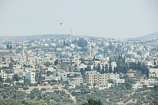
Jenin is a city in the State of Palestine, in the Israeli-occupied West Bank. The city serves as the administrative center of the Jenin Governorate of Palestine and is a major center for the surrounding towns. Jenin came under Israeli occupation in 1967, and was put under the administration of the Palestinian National Authority as Area A of the West Bank in 1993.

<span class="mw-page-title-main">Gaza City</span> Ancient Levantine metropolis and modern city in Palestine

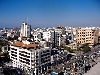
Gaza, also called Gaza City, is a Palestinian city in the Gaza Strip, with a population of 590,481, making it the largest city in the State of Palestine.

<span class="mw-page-title-main">Palestinian territories</span> Occupied Palestinian territory in the Middle East

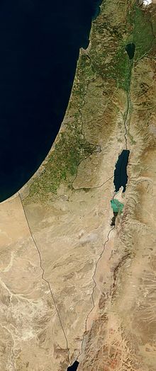
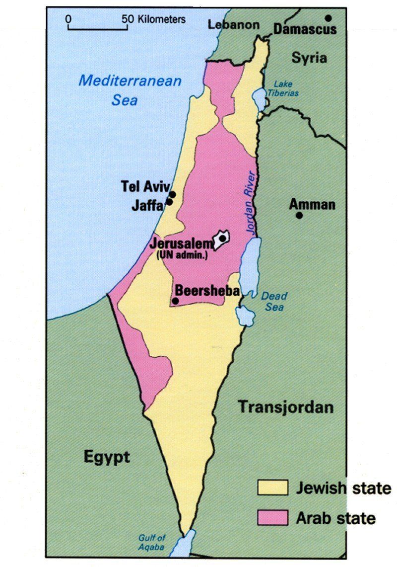
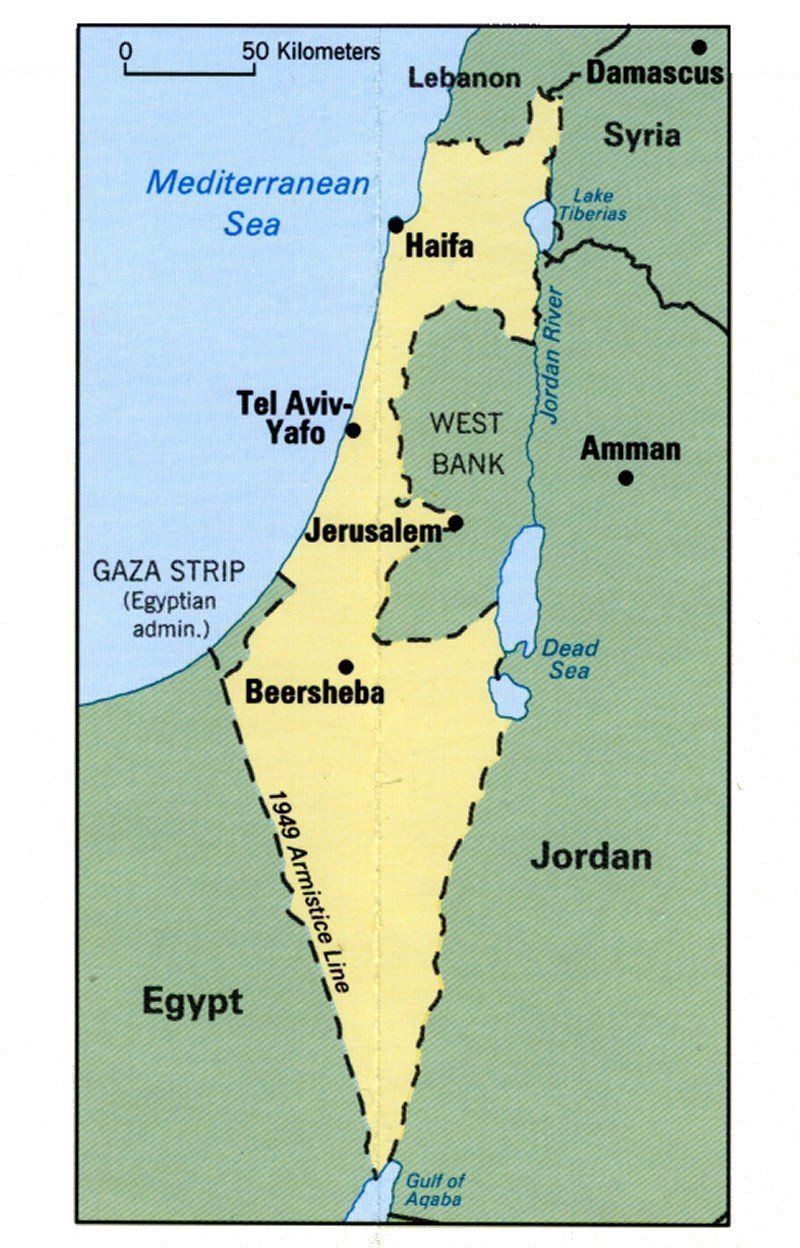
The Palestinian territories are the two regions of the former British Mandate for Palestine that have been occupied by Israel since the Six-Day War of 1967, namely the West Bank and the Gaza Strip. The International Court of Justice (ICJ) has referred to the West Bank, including East Jerusalem, as "the Occupied Palestinian Territory", and this term was used as the legal definition by the ICJ in its advisory opinion of July 2004. The term occupied Palestinian territory was used by the United Nations and other international organizations between October 1999 and December 2012 to refer to areas controlled by the Palestinian National Authority, but from 2012, when Palestine was admitted as one of its non-member observer states, the United Nations started using exclusively the name State of Palestine. The European Union (EU) also uses the term "occupied Palestinian territory". The government of Israel and its supporters use the label "disputed territories" instead.

<span class="mw-page-title-main">Nablus</span> Palestinian city in the northern West Bank

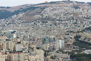
Nablus is a Palestinian city in the West Bank, located approximately 49 kilometres (30 mi) north of Jerusalem, with a population of 156,906. Located between Mount Ebal and Mount Gerizim, it is the capital of the Nablus Governorate and a commercial and cultural centre of the State of Palestine, home to An-Najah National University, one of the largest Palestinian institutions of higher learning, and the Palestine Stock Exchange. Nablus is under the administration of the Palestinian National Authority (PNA).

<span class="mw-page-title-main">Tubas (city)</span> Municipality type A in Tubas, Palestine

Tubas is a Palestinian city in the northeastern West Bank, located northeast of Nablus, west of the Jordan Valley. A city of over 21,000 inhabitants, it serves as the economic and administrative center of the Tubas Governorate of the State of Palestine. Its urban area consists of 2,271 dunams. It is governed by a municipal council of 15 members and most of its working inhabitants are employed in agriculture or public services.

<span class="mw-page-title-main">Quds Governorate</span> Governorate of Palestine

The Quds Governorate, also Jerusalem Governorate, is one of the 16 governorates of Palestine and located in the central part of the West Bank. The current governor, appointed by the Palestinian National Authority, is Adnan Ghaith since 2018, who succeeded to Adnan al-Husayni, appointed in 2008. The Governorate has two sub-districts: Jerusalem J1, which includes the localities within the territory controlled by the Israeli Jerusalem municipality, and Jerusalem J2, which includes the remaining parts of the Jerusalem Governorate. The district capital of the Governorate is East Jerusalem (al-Quds).

<span class="mw-page-title-main">Salfit</span> Municipality type A in State of Palestine

Salfit is a Palestinian city in the central West Bank, and the capital of the Salfit Governorate of the State of Palestine. Salfit is located at an altitude of 570 meters (1,870 ft), adjacent to the Israeli settlement of Ariel. According to the Palestinian Central Bureau of Statistics (PCBS), Salfit had a population of 10,911 in 2017. Since the 1995 Interim Agreement on the West Bank and the Gaza Strip, Salfit, located in Area A, has been administered by the Palestinian National Authority, while continuing under Israeli military occupation.

<span class="mw-page-title-main">Barta'a</span> Town in Haifa/Jenin, Israel/State of Palestine

Barta'a is a town in Israel and Palestine that straddles both sides of the Green Line, in the Wadi Ara region.

<span class="mw-page-title-main">Telephone numbers in the State of Palestine</span>

The country calling code +970 is reserved for telephone numbers in the State of Palestine.

<span class="mw-page-title-main">Deir Istiya</span> Municipality type D in Salfit, State of Palestine

Deir Istiya is a Palestinian town of 3,696 located in the Salfit Governorate of the State of Palestine, in the northern West Bank, 15 kilometers (9.3 mi) southwest of Nablus. The built-up area of Deir Istiya is 74 dunams, and its old city has about thirty families.

<span class="mw-page-title-main">Nabi Samwil</span> Palestinian village north of Jerusalem

An-Nabi Samwil, also called al-Nabi Samuil, is a Palestinian village in the Quds Governorate of the State of Palestine, located in the West Bank, four kilometers north of Jerusalem. The village is built up around the Mosque of Nabi Samwil, containing the Tomb of Samuel; the village's Palestinian population has since been removed by the Israeli authorities from the village houses to a new location slightly down the hill. The village had a population of 234 in 2017.

<span class="mw-page-title-main">Nabi Salih</span> Local Development Committee in State of Palestine

Nabi Salih is a small Palestinian village in the Ramallah and al-Bireh Governorate in the central West Bank, located 20 kilometers northwest of Ramallah. It had a population of 522 in 2017. It is noted for the weekly marches to protest the occupation undertaken since 2010, a practice suspended in 2016, after 350 villagers were estimated to have suffered injuries in clashes with Israeli troops over that period.

<span class="mw-page-title-main">2009 Arab Capital of Culture</span>

Al-Quds Arab Capital of Culture was the name given to Arab Capital of Culture programme in 2009. The programme, organised by UNESCO and the Arab League, is designed to promote Arab culture and encourage cooperation in the Arab world. The 2009 event was the 14th programme since its establishment in 1996.

Kafr Qud is a Palestinian village in the Jenin Governorate in the northern West Bank, located west of Jenin. According to the Palestinian Central Bureau of Statistics (PCBS) census, it had a population of 1,143 in 2007 and 1,553 in 2017.

This is a list of individual incidents and statistical breakdowns of incidents of violence between Israel and Palestinian dissident factions in 2014 as part of the Israeli–Palestinian conflict.

Events in the year 2020 in State of Palestine.

<span class="mw-page-title-main">Saeed Abu Ali</span> Palestinian politician and jurist (born 1955)

Saeed Abdul Rahman Ahmed Abu Ali is a Palestinian politician and jurist. He held important roles in the Palestinian presidency. He was the governor of the governorates of Nablus, Ramallah and Al-Bireh. Also was the Palestinian Minister of Interior, and he currently holds the position of Assistant Secretary-General of the League of Arab Nations.

The following is a timeline of events during the Israeli–Palestinian conflict in 2020.

References

  1. "Note that the term Palestine has historically referred to the region which today incorporates Israel as well as the Palestinian territories. The current position was expressed by Mahmoud Abbas in his September 2011 speech to the United Nations: 'When we adopted this program, we were taking a painful and very difficult step for all of us, especially those, including myself, who were forced to leave their homes and their towns and villages, carrying only some of our belongings and our grief and our memories and the keys of our homes to the camps of exile and the Diaspora in the 1948 Al-Nakba, one of the worst operations of uprooting, destruction and removal of a vibrant and cohesive society that had been contributing in a pioneering and leading way in the cultural, educational and economic renaissance of the Arab Middle East. Yet, because we believe in peace and because of our conviction in international legitimacy, and because we had the courage to make difficult decisions for our people, and in the absence of absolute justice, we decided to adopt the path of relative justice – justice that is possible and could correct part of the grave historical injustice committed against our people. Thus, we agreed to establish the State of Palestine on only 22% of the territory of historical Palestine – on all the Palestinian Territory occupied by Israel in 1967.'"
  2. Martijn Schoonvelde (26 June 2009). "Palestinian Territories". Archived from the original on 3 June 2009. Retrieved 26 July 2009.
  3. Sela and Ma'oz, 1997, p. 16.

Bibliography

Gnome-globe.svg Wikimedia Atlas of Palestine

Maps