Pabst Plan

Last updated
Map of the plan. The Pabst Plan Warsaw 1.jpg
Map of the plan.

The Pabst Plan (German : Neue deutsche Stadt Warschau, "New German city of Warsaw") was a Nazi German urban plan to reconstruct the city of Warsaw as a Nazi model city. Named after its creator Friedrich Pabst, [1] the Nazis' "Chief Architect for Warsaw", the plan assumed that Warsaw, the historical capital of Poland and a city of 1.5 million inhabitants, would be completely destroyed and rebuilt as a small German town of not more than 130,000 inhabitants.

Contents

In modern historical works the term is used to denote any of the German World War II plans concerning the destruction and reconstruction of Warsaw. In particular the "Pabst Plan" refers to a plan prepared by Hubert Gross and Otto Nurnberger in 1940 and another plan, prepared by Pabst himself in 1942. Both plans envisioned the destruction of most of Warsaw with its historical monuments and residential areas. In its place a new model city was to be created as a seat for the German ruling class of the occupied Polish territories. It was to house a large Parteivolkshalle ("People's Party Hall") in place of the Royal Castle in Warsaw and serve as a major transportation hub.

After the 1944 Warsaw Uprising, the Germans decided to destroy the city in its entirety.

History

Pre-war planning

The destruction of the city was already planned long before its almost total destruction in 1944, even prior to the start of World War II. On 20 June 1939, while Adolf Hitler was visiting an architectural bureau in Würzburg, his attention was captured by a project to create a future "German" town—Warsaw (German : Warschau, Polish : Warszawa),[ citation needed ] which later became known as the Pabst Plan. Friedrich Pabst prepared a technical plan for the annihilation of Warsaw and the complete ethnic cleansing of its native Polish population, with Polish Jews condemned to be the first destined for extermination. It envisaged the transformation of the Polish capital into a new, provincial German town, containing an exclusively ethnic German population of no more than 130,000 people on the left bank supported by a slave labour camp of 80,000 Poles on the right bank of the Vistula. Warsaw's total population in 1935 was around 1.3 million, consisting of Poles, Jews, and other minorities, which meant that putting the new urbanization plan to work would require the complete removal of its entire population. The project included 15 separate plans and photos, and solid pre-build documentation. Among all the pages of the project the most important is a colored plan of the future town which was created by German architects in 1:20 000 scale titled Die neue deutsche Stadt Warschau (Warsaw, the New German City). The final table bore the caption Der Abbau der Polenstadt und der Aufbau der Deutschen Stadt (The Destruction of the Polish City and the Construction of the German City).

Some parts of the project that were showing Warsaw's urban development from the second half of 17th century until the year 1935 were based on Polish documentation from 1935 and presumably on scientific sources prepared for Warsaw’s Territorial Development of Communication and Transportation by Prof. O. Sosnowski. All these sources were skillfully extracted long before the war. At an early stage, thanks to German deception based on the false pretense of doing scientific research, the German planners concealed the hidden agenda necessary for creating such a plan. German scholars, historians, conservators and professors of architecture, and other experts were enlisted to catalogue all of the most important and culturally significant landmarks of the city, the most exquisite churches and public buildings, and key library collections, artworks, and sculptures.

The "German Varsavia" was planned to be a built on the crossroad of German highways and railroad networks. It covered a 6 km² built-up area plus 1 km² of Warsaw's centuries-old Prague district, for a combined 7 km² area, with parks and green areas bringing to a total of 15 km². The 7 km² of buildings was just 1/20 of the existing Polish capital city and was very different from the actual existing road network of 1939. The whole town center was to be built into a net of narrow, picturesque streets, resembling the planning of a typical German town. The modern and wide Polish capital avenues (like Marszałkowska, Twarda, Mokotowska, Dzika, Oś Saska, Oś Stanisławowska) would have been erased forever with all their monumental and beautiful buildings and palaces. Only the remains of the Old Town district (without the Polish King's Castle), the King's Baths Palace (Polish : Łazienki Królewskie), and Belvedere (Polish : Belweder), and modified parts of the Vistula riverside buildings would have been saved.

Wartime implementation of the plan

Bundesarchiv N 1576 Bild-003, Warschau, Bettelnde Kinder.jpg
Ghetto children

After the start of military operations and the fall of the capital into German hands the project was updated, incorporating the city's partial destruction in the September offensive of 1939. The project was soon to be included as a part of the overall Germanization plan of the East, the genocidal Generalplan Ost.

On October 8, 1939 western areas of Poland were annexed by the Third Reich, and on October 12, 1939 the central areas of Poland were incorporated into the General Government by Hitler's decrees. The capital of the Gubernia was placed in Kraków (Krakau, Cracow) for security reasons. The occupying German elite was afraid of unsubdued Warsaw.

The plan was to be implemented in several stages. One of the parts for the plan, the "Demolition of the Polish City and the Construction of the German City" (Abbau der Polen-Stadt und der Aufbau der Deutschen Stadt) included a list of the Polish capital's centers of life destined for destruction, put in chronological order based on planned liquidation date. The planners also decided to use the destruction caused by bombings and fires during the September 1939 seizure of the city as a pretext for the urbanistic changes. Another part of the plan included a detailed map of the anticipated destruction showing almost all buildings destroyed coincidentally according to the original plan. In reality only 10 percent of the buildings were destroyed in 1939, with total civilian and military losses of around 12,000 killed and 66,000 wounded.

In the "Small Plan" (Kleine Planung), the population of Warsaw was to be limited to 500,000 people. The first group affected by this measure was Warsaw's Jewish population, which the German planners assumed would be removed (Judenaussiedlung) from an area of around 482 hm² and forcibly relocated to a "Jewish Quarter" (Judenviertel) which was only 30% the size, i.e., 143 hm² surrounded by walls and watchtowers. In 1940, the Nazis turned the northern part of mid-town Warsaw (Wola and Muranow) into a Jewish ghetto. The Jewish Ghetto was planned to accommodate around 30,000 of the capital's inhabitants that were of Jewish origin; however it eventually held nearly 400,000 people living in deplorable conditions. The next step for decreasing the original population of the city was the systematic displacement of people captured and destined for either slave labor in the Third Reich or extermination in concentration and labor camps. As early as 1940 all inhabitants of Warsaw were subject to round-ups (łapanki) and mass shootings in the streets. Nearly 250,000 civilians were eventually murdered this way. Memorial plaques can be seen throughout Warsaw today commemorating this indiscriminate program of ethnic cleansing of men, women and children. Those who did not manage to escape were sent to death camps at Auschwitz or Majdanek or forced into labour in Germany. Among the 2,857,500 Poles working as slave labor in the Third Reich during World War II, a significant percentage was composed of Warsaw and Warsaw province inhabitants.

Hans Frank (center, wearing a glove after a suicide attempt shortly after his arrest) at the Nuremberg trial, with Alfred Jodl and Alfred Rosenberg Alfred Jodl, Hans Frank, Alfred Rosenberg.jpg
Hans Frank (center, wearing a glove after a suicide attempt shortly after his arrest) at the Nuremberg trial, with Alfred Jodl and Alfred Rosenberg

On 6 February 1940 the German mayor of the city presented an unusual gift to Hans Frank, the Governor-General of the Occupied Polish Territories. The gift was a full documentation of the new German town Warsaw (Neue deutsche Stadt Warschau), the so-called Pabst Plan, prepared by German architects Hubert Gross and Otto Nurnberger.

From July 1943 to July 1944, prisoners from the Warsaw concentration camp were tasked with clearing 2.6 million cubic meters of rubble, in order to convert the former Warsaw Ghetto into a park. [2]

See also

Bibliography

Related Research Articles

<span class="mw-page-title-main">Warsaw Ghetto</span> Nazi ghetto in occupied Poland

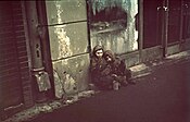
The Warsaw Ghetto was the largest of the Nazi ghettos during World War II and the Holocaust. It was established in November 1940 by the German authorities within the new General Government territory of occupied Poland. At its height, as many as 460,000 Jews were imprisoned there, in an area of 3.4 km2 (1.3 sq mi), with an average of 9.2 persons per room, barely subsisting on meager food rations. From the Warsaw Ghetto, Jews were deported to Nazi concentration camps and mass-killing centers. In the summer of 1942, at least 254,000 ghetto residents were sent to the Treblinka extermination camp during Großaktion Warschau under the guise of "resettlement in the East" over the course of the summer. The ghetto was demolished by the Germans in May 1943 after the Warsaw Ghetto Uprising had temporarily halted the deportations. The total death toll among the prisoners of the ghetto is estimated to be at least 300,000 killed by bullet or gas, combined with 92,000 victims of starvation and related diseases, the Warsaw Ghetto Uprising, and the casualties of the final destruction of the ghetto.

<span class="mw-page-title-main">General Government</span> German-occupied zone in Poland in World War II

The General Government, formally the General Governorate for the Occupied Polish Region, was a German zone of occupation established after the invasion of Poland by Nazi Germany, Slovakia and the Soviet Union in 1939 at the onset of World War II. The newly occupied Second Polish Republic was split into three zones: the General Government in its centre, Polish areas annexed by Nazi Germany in the west, and Polish areas annexed by the Soviet Union in the east. The territory was expanded substantially in 1941, after the German Invasion of the Soviet Union, to include the new District of Galicia. The area of the Generalgouvernement roughly corresponded with the Austrian part of the Polish–Lithuanian Commonwealth after the Third Partition of Poland in 1795.

<span class="mw-page-title-main">Skierniewice</span> Polish city in the Łódź Voivodeship

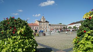
Skierniewice is a city in central Poland with 47,031 inhabitants (2021), situated in the Łódź Voivodeship. It is the capital of Skierniewice County. The town is situated almost exactly halfway between Łódź and Warsaw. Through the town runs the small river Łupia, also called Skierniewka.

<span class="mw-page-title-main">Łask</span> Place in Łódź Voivodeship, Poland

Łask is a town in central Poland with 16,925 inhabitants (2020). It is the capital of Łask County, and is situated in Łódź Voivodeship. The Polish Air Force's 32nd Air Base is located nearby. It is located in the Sieradz Land.

<span class="mw-page-title-main">Siedlce</span> Place in Masovian Voivodeship, Poland

Siedlce is a city in eastern Poland with 77,354 inhabitants. Situated in the Masovian Voivodeship, previously the city was the capital of a separate Siedlce Voivodeship (1975–1998). The city is situated between two small rivers, the Muchawka and the Helenka, and lies along the European route E30, around 90 kilometres (56 mi) east of Warsaw. It is the fourth largest city of the Voivodeship, and the seat of the Roman Catholic Diocese of Siedlce. Siedlce is a local educational, cultural and business center.

<span class="mw-page-title-main">Pruszków</span> Place in Masovian Voivodeship, Poland

Pruszków is a city in east-central Poland, situated in the Masovian Voivodeship since 1999. It was previously in Warszawa Voivodeship (1975–1998). Pruszków is the capital of Pruszków County, located along the western edge of the Warsaw urban area.

<span class="mw-page-title-main">Zgierz</span> Place in Łódź Voivodeship, Poland

Zgierz is a city in central Poland, located just to the north of Łódź, and part of the metropolitan area centered on that city. As of 2021, it had a population of 54,974. Located within the historic Łęczyca Land, it is the capital of Zgierz County in the Łódź Voivodeship.

<span class="mw-page-title-main">Jewish Combat Organization</span> World War ll Jewish resistance movement in Nazi-occupied Poland

The Jewish Combat Organization was a World War II resistance movement in occupied Poland, which was instrumental in organizing and launching the Warsaw Ghetto Uprising. ŻOB took part in a number of other resistance activities as well.

<span class="mw-page-title-main">Warsaw concentration camp</span> Nazi concentration camp in Warsaw during World War II

The Warsaw concentration camp was a German concentration camp in occupied Poland during World War II. It was formed on the base of the now-nonexistent Gęsiówka prison, in what is today the Warsaw neighbourhood of Muranów, on the order of Reichsführer-SS Heinrich Himmler. The camp operated from July 1943 to August 1944.

<span class="mw-page-title-main">Zaklików</span> Town in Poland

Zaklików is a town in Poland, located in the Subcarpathian Voivodeship, in Stalowa Wola County. It is located 113.1 miles (182 km) SSE of Warsaw and 50 miles (80 km) from Lublin. For about 300 years of its early history Zaklików was incorporated as a city, but it lost its city charter in punishment for the January Uprising against the imperial rule. It was reinstated as a city on 1 January 2014. Zaklików lies approximately 21 kilometres (13 mi) north of Stalowa Wola and 82 km (51 mi) north of the regional capital Rzeszów.

<span class="mw-page-title-main">Pławno, Łódź Voivodeship</span> Village in Łódź Voivodeship, Poland

Pławno is a village in the administrative district of Gmina Gidle, within Radomsko County, Łódź Voivodeship, in south-central Poland. The village has a population of 1,200. It lies approximately 4 kilometres (2 mi) north of Gidle, 10 km (6 mi) south of Radomsko, and 90 km (56 mi) south of the regional capital Łódź. It is located in the Sieradz Land.

<span class="mw-page-title-main">Jewish ghettos established by Nazi Germany</span> Areas of Jewish imprisonment during the Holocaust

Beginning with the invasion of Poland during World War II, the Nazi regime set up ghettos across German-occupied Eastern Europe in order to segregate and confine Jews, and sometimes Romani people, into small sections of towns and cities furthering their exploitation. In German documents, and signage at ghetto entrances, the Nazis usually referred to them as Jüdischer Wohnbezirk or Wohngebiet der Juden, both of which translate as the Jewish Quarter. There were several distinct types including open ghettos, closed ghettos, work, transit, and destruction ghettos, as defined by the Holocaust historians. In a number of cases, they were the place of Jewish underground resistance against the German occupation, known collectively as the ghetto uprisings.

<span class="mw-page-title-main">Radziejów</span> Place in Kuyavian-Pomeranian Voivodeship, Poland

Radziejów is a town in Poland, in Kuyavian-Pomeranian Voivodeship, about 45 km south of Toruń. It is the capital of Radziejów County. Its population is 5,696 (2010).

<span class="mw-page-title-main">Żychlin</span> Place in Łódź Voivodeship, Poland

Żychlin is a town in Kutno County, Łódź Voivodeship, Poland, about 50 north of Łódź and 90 kilometres west of Warsaw. It has 7,964 inhabitants (2020).

<span class="mw-page-title-main">Błonie</span> Place in Masovian Voivodeship, Poland

Błonie is a town in Warsaw West County, Masovian Voivodeship, Poland, with a population of 12,058 as of December 2021.

<span class="mw-page-title-main">Destruction of Warsaw</span> 1944 Nazi razing of Warsaw

The destruction of Warsaw was Nazi Germany's razing of the city in late 1944, after the 1944 Warsaw Uprising of the Polish resistance. The uprising infuriated German leaders, who decided to destroy the city in retaliation.

<span class="mw-page-title-main">Jewish ghettos in Europe</span> Neighborhoods of European cities in which Jews were permitted to live

In the early modern era, European Jews were confined to ghettos and placed under strict regulations as well as restrictions in many European cities. The character of ghettos fluctuated over the centuries. In some cases, they comprised a Jewish quarter, the area of a city traditionally inhabited by Jews. In many instances, ghettos were places of terrible poverty and during periods of population growth, ghettos had narrow streets and small, crowded houses. Residents had their own justice system. Around the ghetto stood walls that, during pogroms, were closed from inside to protect the community, but from the outside during Christmas, Pesach, and Easter Week to prevent the Jews from leaving at those times.

<span class="mw-page-title-main">History of Warsaw</span> Aspect of history

The history of Warsaw spans over 1400 years. In that time, the city evolved from a cluster of villages to the capital of a major European power, the Polish–Lithuanian Commonwealth—and, under the patronage of its kings, a center of enlightenment and otherwise unknown tolerance. Fortified settlements founded in the 9th century form the core of the city, in today's Warsaw Old Town.

<span class="mw-page-title-main">Radom Ghetto</span> Nazi ghetto in occupied Poland

Radom Ghetto was a Nazi ghetto set up in March 1941 in the city of Radom during the Nazi occupation of Poland, for the purpose of persecution and exploitation of Polish Jews. It was closed off from the outside officially in April 1941. A year and a half later, the liquidation of the ghetto began in August 1942, and ended in July 1944, with approximately 30,000–32,000 victims deported aboard Holocaust trains to their deaths at the Treblinka extermination camp.

Executions in the ruins of the Warsaw Ghetto (1943–1944) – mass executions of Polish Political prisoners and people of Jewish descent carried out secretly by German occupiers in the ruins of the Warsaw Ghetto.

References

  1. pl:Friedrich Pabst
  2. The Order of Terror: The Concentration Camp, Princeton University Press, Wolfgang Sofsky page 337