Pacific Proving Grounds

Last updated

Pacific Proving Grounds / Pacific Test Site
primarily in the Marshall Islands
Operation Crossroads Baker Edit.jpg
The United States began using the Marshall Islands as a nuclear testing site beginning in 1946.
Locator Dot.svg
Pacific Proving Grounds.png
Map showing location of the Pacific Proving Grounds relative to rest of Pacific Ocean
Type Nuclear testing range
Area~140,000 sq mi (360,000 km2)
Site information
Operator United States Department of Energy
StatusInactive
Site history
In use1947–present (last nuclear test in 1962)
Test information
Nuclear tests105

The Pacific Proving Grounds was the name given by the United States government to a number of sites in the Marshall Islands and a few other sites in the Pacific Ocean at which it conducted nuclear testing between 1946 and 1962. The U.S. tested a nuclear weapon (codenamed Able) on Bikini Atoll on June 30, 1946. This was followed by Baker on July 24, 1946 (dates are Universal Time, local dates were July 1 and 25, respectively).

Contents

On July 18, 1947, the United States secured an agreement with the United Nations to govern the islands of Micronesia as the Trust Territory of the Pacific Islands, a strategic trusteeship territory. This is the only such trusteeship ever granted by the United Nations to the United States. [1] The Trust Territory comprised about 2,000 islands spread over 3,000,000 square miles (7,800,000 km2) of the North Pacific Ocean. Five days later, the United States Atomic Energy Commission established the Pacific Proving Grounds. [2]

The United States conducted 105 atmospheric and underwater (i.e., not underground) nuclear tests in the Pacific, many with extremely high yields. While the Marshall Islands testing composed 14% of all U.S. tests, it composed nearly 80% of the total yields of those detonated by the U.S., with an estimated total yield of around 210 megatons, with the largest being the 15 Mt Castle Bravo shot of 1954 which spread considerable nuclear fallout on many of the islands, including several that were inhabited and some that had not been evacuated. [3]

Many of the islands which were part of the Pacific Proving Grounds are still contaminated from the nuclear fallout, and many of those who were living on the islands at the time of testing have suffered from an increased incidence of various health problems. Through the Radiation Exposure Compensation Act of 1990, at least $759 million has been paid to Marshall Islanders as compensation for their exposure to U.S. nuclear testing. Following the Castle Bravo accident, the U.S. paid $15.3 million to Japan. [4]

Scientists have calculated that the residents of the Marshall Islands during their lifetimes will be diagnosed with an added 1.6% (with 90% uncertainty range 0.4% to 3.4%) cancers attributable to fallout-related radiation exposures. The cancers are the consequence of exposure to ionizing radiation from weapons test fallout deposited during the testing period (1948–1958) and from residual radioactive sources during the subsequent 12 years (1959–1970). [5]

Strategic Trust Territory

On July 18, 1947, the United States convinced the United Nations to designate the islands of Micronesia as the Strategic Trust Territory. This was the only trust ever granted by the U.N. [1] The directive stated that the United States should "promote the economic advancement and self-sufficiency of the inhabitants, and to this end shall... protect the inhabitants against the loss of their lands and resources..." [6]

The United States Navy controlled the Trust from a headquarters in Guam until 1951, when the United States Department of the Interior took over control, administering the territory from a base in Saipan. [7]

Despite the promise to "protect the inhabitants", from July 1946 through July 1947, the residents of Bikini Atoll who had been relocated to Rongerik Atoll were starving for lack of food. A team of U.S. investigators concluded in late 1947 that the islanders must be moved immediately. Press from around the world harshly criticized the U.S. Navy for ignoring the people. Harold Ickes, a syndicated columnist, wrote "The natives are actually and literally starving to death." [6] The islanders were later moved again to Kili Island, which is not surrounded by a reef. The island does not support the inhabitants' traditional way of life.

Radiation exposure

Because of the large amount of atmospheric testing, and especially the Castle Bravo accident of 1954, many of the islands which were part of the Pacific Proving Grounds are still contaminated by nuclear fallout.

Scientists calculated in 2010 that during the lifetimes of members of the Marshall Islands population, potentially exposed to ionizing radiation from weapons test fallout deposited during the testing period (1948–1958) and from residual radioactive sources during the subsequent 12 years (1959–1970), perhaps 1.6% (with 90% uncertainty range 0.4% to 3.4%) of all cancers might be attributable to fallout-related radiation exposures. By sub-population, the projected proportion of cancers attributable to radiation from fallout from all nuclear tests conducted in the Marshall Islands is 55% (with a 28% to 69% uncertainty range) among 82 persons exposed in 1954 on Rongelap Atoll and Ailinginae Atoll, 10% (2.4% to 22%) for 157 persons exposed on Utirik Atoll, and 2.2% (0.5% to 4.8%) and 0.8% (0.2% to 1.8%), respectively, for the much larger populations exposed in mid-latitude locations including Kwajalein and in southern locations including Majuro. [5]

Compensation

Since 1956, the U.S. has paid at least $759 million to Marshall Islanders as compensation for their exposure to U.S. nuclear testing. Following the Castle Bravo accident on March 1, 1954, the U.S. paid $15.3 million to Japan. [4]

In June 1983, the U.S. and the Marshall islanders signed the Compact of Free Association, which gave the Marshall Islands independence. The Compact became effective in 1986 and was subsequently modified by the Amended Compact that became effective in 2004. [8] It also established the Nuclear Claims Tribunal, which was given the task of adjudicating compensation for victims and families affected by the nuclear testing program. Section 177 of the compact provided for reparations to the Bikini islanders and other northern atolls for damages. It included $150 million to be paid over a 15-year period ending in 2001. During that time, payments averaging about $18 million per year were made to the peoples of Bikini, Enewetak, Rongelap, and Utrik for medical and radiological monitoring, and in response to claims. [9] [10] The payments began in 1987 with $2.4 million paid annually to the entire Bikini population, while the remaining $2.6 million is paid into The Bikini Claims Trust Fund. This trust is intended to exist in perpetuity and to provide the islanders a 5% payment from the trust annually. [10]

The United States also passed the Radiation Exposure Compensation Act in 1990 to allow individuals to file claims for compensation in relation to testing as well as those employed at nuclear weapons facilities.

On March 5, 2001, the Nuclear Claims Tribunal ruled against the United States for damages done to the islands and its people. [6] The Nuclear Claims Tribunal awarded the islanders a total of $563,315,500 after deducting past awards. However, the U.S. Congress has failed to fund the settlement. The only recourse is for the Bikini people to petition the U.S. Congress to fund the payment and fulfill this award. The United States Supreme Court turned down the islanders' appeal of the United States courts of appeals decision that refused to compel the government to fund their claim.

As of 2012, trusts remaining from the settlement produced about US$6 to $8 million annually in investment income, and the trusts paid out about US$15,000 per family each year in benefits. [11]

Testing chronology

Operation Crossroads (1946)

The "Baker" shot of Operation Crossroads in 1946 was an underwater shot. Crossroads baker explosion.jpg
The "Baker" shot of Operation Crossroads in 1946 was an underwater shot.

The first use of the Pacific Proving Grounds was during Operation Crossroads, the first nuclear testing done after the atomic bombing of Hiroshima and Nagasaki. Two fission bombs, both with a yield of 21 kilotons, were tested at Bikini Atoll. "Able" was detonated at an altitude of 520 ft (158 m) on July 1, 1946, and "Baker" was detonated at a depth of 90 ft (27 m) underwater on July 25. Both tests used a flotilla of obsolete vessels from World War II with the intent of learning the effects of nuclear weapons on naval fleets. The "Baker" shot created a large condensation cloud and spread much more radioactive water onto the ships than was expected; many of the surviving ships became too "hot" to be used or decontaminated and eventually had to be sunk.

Operation Sandstone (1948)

Three weapons were detonated on the Enewetak Atoll as part of Operation Sandstone in 1948.

Operation Greenhouse (1951)

Four weapons were detonated on the Enewetak Atoll as part of Operation Greenhouse in 1951. Two are of particular note: Greenhouse "Item" was the first use of a boosted fission weapon, and "George" was a thermonuclear experiment designed to prove the feasibility of the Teller-Ulam design for the possibility of developing hydrogen bombs.

Operation Ivy (1952)

After the Ivy Mike shot, only a large crater (at left) remained of the island of Elugelab. Ivy Mike - Elugelab pt2.jpg
After the Ivy Mike shot, only a large crater (at left) remained of the island of Elugelab.

Two weapons were detonated at the Enewetak Atoll as part of Operation Ivy in 1952. One of them, Ivy King, was the largest pure-fission bomb ever detonated, with a yield of 500 kilotons, [12] and the other, Ivy Mike, was the first hydrogen bomb device (it was too large to be an actual weapon), with a yield of 10.4 Mt.

Operation Castle (1954)

The Castle Bravo test of 1954 spread nuclear fallout across the Marshall Islands, parts of which were still inhabited. Bravo fallout2.png
The Castle Bravo test of 1954 spread nuclear fallout across the Marshall Islands, parts of which were still inhabited.

Six very large nuclear tests were conducted at the Bikini Atoll and the Enewetak Atoll as part of Operation Castle in 1954. The most notable was Castle Bravo, which was the first deployable (dry fuel) hydrogen bomb developed by the United States. Its yield, at 15 Mt, was over twice as powerful as was predicted, and remains the largest weapon ever detonated by the United States. It spread nuclear fallout over a wide area, including the Enewetak Atoll, Rongerik Atoll, Ailinginae Atoll, and Rongelap Atoll. The U.S. Navy evacuated the islanders within the next few days, but many of the natives were exposed to radiation prior to evacuation. The fishermen aboard the Japanese fishing vessel, the Daigo Fukuryu Maru , were additionally exposed and one man died soon after from complications of radiation sickness, resulting in considerable international controversy.

Operation Redwing (1956)

Seventeen nuclear weapons were detonated on the Bikini and Enewetak Atolls as part of Operation Redwing in 1956. Many of them were designed to prove the feasibility of numerous thermonuclear weapon designs, with yields ranging from around 2 to 5 Mt.

Operation Hardtack I (1958)

Thirty-five weapons were detonated at the Bikini Atoll, Enewetak Atoll, and Johnston Island as part of Operation Hardtack I in 1958.

Operation Dominic (1962)

Thirty-six weapons were detonated at sites in the Pacific Ocean in the vicinity of Christmas Island and Johnston Atoll as part of Operation Dominic I. Though these tests were not conducted in the Marshall Islands, they are officially considered part of the Pacific Proving Grounds. [13] The portion of the Dominic series of tests that were high altitude nuclear explosions were known as Operation Fishbowl, though not all were successful (one detonated on launchpad and resulted in a substantial plutonium contamination). [14] Two of the tests were of operational weapons systems—the ASROC anti-submarine rocket and the Polaris SLBM (the latter test, Frigate Bird, was the only operational submarine-launched ballistic missile test with a live warhead ever undertaken by the USA).

Partial Test Ban Treaty

The signing of the Partial Test Ban Treaty in 1963 forbade atmospheric and underwater nuclear weapons, and so no further U.S. tests were conducted at the Pacific Proving Grounds, with all but ten occurring at the Nevada Test Site until the end of testing in 1992.

Geographical names

The Bikini and Enewetak Atolls are each a collection of islands. Various names have been assigned to the islands over time, and the confusion over the names (and their alternate transliterations) have been the source of much confusion, and in addition, over time islands appear, disappear, separate and join, and are excavated by bombs. Here are the islands listed in clockwise fashion starting with left side of the major inlet into the lagoon in each atoll. The names include the official Marshall Island names, the American military names used after occupation through the atomic testing period, and the Japanese names used while they occupied the islands during World War II, plus names gleaned from other sources.

Islands in the Bikini Atoll
Marshall Islander's name [15] US Military name [15] Japanese name [15] Other found
Aerokoj [Notes 1]
Aerokojlol Peter Airukiraru Aerokoj
Bikdrin Roger Bigiren
Lele Sugar Reere
Enemen Tare Eniman
Enidrik Uncle Enirik
Lukoj Victor Rukoji
Jelete William Chieerete
Adrikan Yoke Arrikan
Oroken Zebra Ourukaen
Bokaetoktok Alpha Bokoaetokutoka
Bokdrlul Bravo Bokororyuru Bokdrolul
Bokbata
Bokonejein
Nam Charlie Namu
Iroij Dog Yurochi
Odrik Easy Yorikku
Lomilik Fox Romurikku
Aomen George Aomeon Aomoen
Bikini How Bikini
Bakantauk Item Bokonfaaku Bokonfuaaku, Bokantuak
Lomelen Jig Yomyaran Iomeman
Enealo King Eniairo
Rojkere Love Rochikarai Rokere
Eonjebi Mike Ionchebi
Eneu Nan Enyu
Islands in the Enewetak Atoll
Marshall Islander's name [15] US Military name [15] Japanese name [15] Other found
Ikuren Glenn Igurin
Mutt Henry Mui, Buganegan [16]
Boken Irwin Pokon Bogan [16]
Ribewon James Ribaion Libiron [16]
Kidrenin Keith Giriinien Girinian, Kiorenen, Grinem [16]
Biken Leroy Rigli Rigili [16]
Unibor Mack
Drekatimon Oscar
Noah
Bokoluo Alice Bogallua [16]
Bokombako Belle Bogumbogo [16]
Kirunu Clara Ruchi Kiruna [17]
Louj Daisy Cochiti
Bocinwotme Edna Bokinwotme, San Idelfonso
Elugelab Flora Eluklab, Eybbivae [16]
Dridrilbwij Gene Teiteiripucci Teiteir, Lidilbut [16]
Bokaidrikdrik Helen Bogairikk, Bogeirik [16]
Boken Irene Bokon, Bogon [16]
Enjebi Janet Engebi
Mijikadrek Kate Mujinikaroku MuzinBaarappu, Mujinkarikku [16]
Kidrinen Lucy Kirinian
Taiwel Percy Billee [16]
Bokenelab Mary Bokonaarappu Bokenelan [17]
Elle Nancy Yeiri
Aej Olive Aitsu
Lujor Pearl Rujoru Rujiyoru [16]
Eleleron Ruby Ebeiru Eberiru [16]
Aomen Sally Aomon
Bijire Tilda Biljiri
Lojwa Ursula Rojga Rojoa [16]
Alembel Vera Aaraanbiru Arambiru [16]
Billae Wilma Piiraar Piirai [16]
Runit Yvonne
Runit Southern Zona
Boko Sam
Munjor Tom
Inedral Uriah
Van
Jinedrol Alvin Chinieero Jinedrol
Ananij Bruce Aniyaanii
Jinimi Clyde Chinimi
Japtan David Anarij
Jedrol Rex Jieroru Jeroru, Muti [16]
Medren Elmer Parry
Bokandretok Walt
Eniwetok Fred Enewetak [17]

See also

Explanatory notes

  1. One map shows Aerokoj separate from Aerokojlol.

Related Research Articles

<span class="mw-page-title-main">Bikini Atoll</span> Coral atoll in the Marshall Islands

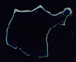
Bikini Atoll, known as Eschscholtz Atoll between the 19th century and 1946, is a coral reef in the Marshall Islands consisting of 23 islands surrounding a 229.4-square-mile (594.1 km2) central lagoon. The Atoll is at the northern end of the Ralik Chain, approximately 530 miles (850 km) northwest of the capital Majuro.

<span class="mw-page-title-main">Enewetak Atoll</span> Coral atoll in the Marshall Islands; site of U.S. nuclear testing during the Cold War

Enewetak Atoll is a large coral atoll of 40 islands in the Pacific Ocean and with its 296 people forms a legislative district of the Ralik Chain of the Marshall Islands. With a land area total less than 5.85 square kilometers (2.26 sq mi), it is no higher than 5 meters (16.4 ft) and surrounds a deep central lagoon, 80 kilometers (50 mi) in circumference. It is the second-westernmost atoll of the Ralik Chain and is 305 kilometers (190 mi) west from Bikini Atoll.

<span class="mw-page-title-main">Operation Crossroads</span> 1946 nuclear weapon tests at Bikini Atoll

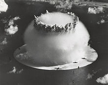
Operation Crossroads was a pair of nuclear weapon tests conducted by the United States at Bikini Atoll in mid-1946. They were the first nuclear weapon tests since Trinity on July 16, 1945, and the first detonations of nuclear devices since the atomic bombing of Nagasaki on August 9, 1945. The purpose of the tests was to investigate the effect of nuclear weapons on warships.

<span class="mw-page-title-main">Nuclear weapons testing</span> Controlled detonation of nuclear weapons for scientific or political purposes

Nuclear weapons tests are experiments carried out to determine the performance, yield, and effects of nuclear weapons. Testing nuclear weapons offers practical information about how the weapons function, how detonations are affected by different conditions, and how personnel, structures, and equipment are affected when subjected to nuclear explosions. However, nuclear testing has often been used as an indicator of scientific and military strength. Many tests have been overtly political in their intention; most nuclear weapons states publicly declared their nuclear status through a nuclear test.

<span class="mw-page-title-main">Operation Castle</span> Series of 1950s US nuclear tests

Operation Castle was a United States series of high-yield (high-energy) nuclear tests by Joint Task Force 7 (JTF-7) at Bikini Atoll beginning in March 1954. It followed Operation Upshot–Knothole and preceded Operation Teapot.

<span class="mw-page-title-main">Ebeye Island</span> Island in the Marshall Islands

Ebeye is the most populous island of Kwajalein Atoll in the Marshall Islands, as well as the center for Marshallese culture in the Ralik Chain of the archipelago. Settled on 80 acres of land, it has a population of more than 15,000. Over 50% of the population is estimated to be under the age of 18.

<span class="mw-page-title-main">Operation Sandstone</span> Series of 1940s US nuclear tests

Operation Sandstone was a series of nuclear weapon tests in 1948. It was the third series of American tests, following Trinity in 1945 and Crossroads in 1946, and preceding Ranger. Like the Crossroads tests, the Sandstone tests were carried out at the Pacific Proving Grounds, although at Enewetak Atoll rather than Bikini Atoll. They differed from Crossroads in that they were conducted by the Atomic Energy Commission, with the armed forces having only a supporting role. The purpose of the Sandstone tests was also different: they were primarily tests of new bomb designs rather than of the effects of nuclear weapons. Three tests were carried out in April and May 1948 by Joint Task Force 7, with a work force of 10,366 personnel, of whom 9,890 were military.

<span class="mw-page-title-main">Rongelap Atoll</span> Coral atoll in the Marshall Islands

Rongelap AtollRONG-gə-lap is an uninhabited coral atoll of 61 islands in the Pacific Ocean, and forms a legislative district of the Ralik Chain of the Marshall Islands. Its total land area is 8 square miles (21 km2). It encloses a lagoon with an area of 1,000 square miles (2,600 km2). It is historically notable for its close proximity to US hydrogen bomb tests in 1954, and was particularly devastated by fallout from the Castle Bravo test. The population asked the US to move them from Rongelap following the test due to high radiation levels with no success so they asked global environmental group Greenpeace to help. The Rainbow Warrior made four trips moving the islanders, their possessions and their homes to the island of Mejato in the Kwajalein Atoll, 180 kilometers away.

<span class="mw-page-title-main">Castle Bravo</span> 1954 U.S. thermonuclear weapon test in the Marshall Islands

Castle Bravo was the first in a series of high-yield thermonuclear weapon design tests conducted by the United States at Bikini Atoll, Marshall Islands, as part of Operation Castle. Detonated on March 1, 1954, the device remains the most powerful nuclear device ever detonated by the United States and the first lithium deuteride-fueled thermonuclear weapon tested using the Teller-Ulam design. Castle Bravo's yield was 15 megatons of TNT [Mt] (63 PJ), 2.5 times the predicted 6 Mt (25 PJ), due to unforeseen additional reactions involving lithium-7, which led to radioactive contamination in the surrounding area.

<span class="mw-page-title-main">Ivy Mike</span> 1952 American nuclear test

Ivy Mike was the codename given to the first full-scale test of a thermonuclear device, in which part of the explosive yield comes from nuclear fusion. Ivy Mike was detonated on November 1, 1952, by the United States on the island of Elugelab in Enewetak Atoll, in the now independent island nation of the Marshall Islands, as part of Operation Ivy. It was the first full test of the Teller–Ulam design, a staged fusion device.

<span class="mw-page-title-main">Rongerik Atoll</span> Coral atoll in the Pacific Ocean

Rongerik Atoll or Rongdrik Atoll is an unpopulated coral atoll of 17 islands in the Pacific Ocean, and is located in the Ralik Chain of the Marshall Islands, approximately 200 kilometers (120 mi) east of Bikini Atoll. Its total land area is only 1.68 square kilometers (0.65 sq mi), but it encloses a lagoon of 144 square kilometers (56 sq mi).

<span class="mw-page-title-main">Operation Hardtack I</span> Series of 1950s US nuclear tests

Operation Hardtack I was a series of 35 nuclear tests conducted by the United States from April 28 to August 18 in 1958 at the Pacific Proving Grounds. At the time of testing, the Operation Hardtack I test series included more nuclear detonations than the total of prior nuclear explosions in the Pacific Ocean. These tests followed the Project 58/58A series, which occurred from 1957 December 6 to 1958, March 14, and preceded the Operation Argus series, which took place in 1958 from August 27 to September 6.

<span class="mw-page-title-main">Ailinginae Atoll</span> Atoll in the Marshall Islands

Ailinginae Atoll is an uninhabited coral atoll of 25 islands in the Pacific Ocean, on the northern end of the Ralik Chain of the Marshall Islands. Its total land area is only 2.8 square kilometers (1.1 sq mi), but it encloses a lagoon of 105.96 square kilometers (40.91 sq mi). It is located approximately 13 kilometers (8.1 mi) west of Rongelap Atoll. The landscape is low-lying with only the top 3 meters (9.8 ft) above sea level. The two entrances into the lagoon are 'Mogiri Pass' and 'Eniibukku Pass'. These are 1.45 and 0.48 kilometers wide respectively.

<span class="mw-page-title-main">Project 4.1</span> Radioactive fallout exposure study and experiment

Project 4.1 was the designation for a medical study and experimentation conducted by the United States of those residents of the Marshall Islands exposed to radioactive fallout from the March 1, 1954 Castle Bravo nuclear test at Bikini Atoll, which had an unexpectedly large yield. Government and mainstream historical sources point to the study being organized on March 6 or March 7, 1954, less than a week after the Bravo shot.

<span class="mw-page-title-main">Jeton Anjain</span>

Jeton Anjain was a Minister of Health and a senator of the Marshall Islands Parliament. He received the Goldman Environmental Prize in 1992, for his efforts to help people from the Rongelap Atoll, which was subject to nuclear contamination after the test of the Castle Bravo hydrogen bomb in 1954. In 1991, he and the Rongelap People were awarded the Right Livelihood Award for "their steadfast struggle against United States nuclear policy in support of their right to live on an unpolluted Rongelap island."

Lijon Eknilang was a Marshallese activist and nuclear fallout survivor. Eknilang advocated on behalf of residents of Rongelap Atoll, who were victims of nuclear fallout stemming from the Castle Bravo hydrogen bomb test at Bikini Atoll in 1954.

<span class="mw-page-title-main">Nuclear testing at Bikini Atoll</span> US nuclear testing on Bikini Atoll in the Marshall Islands

Nuclear testing at Bikini Atoll consisted of the detonation of 24 nuclear weapons by the United States between 1946 and 1958 on Bikini Atoll in the Marshall Islands. Tests occurred at 7 test sites on the reef itself, on the sea, in the air, and underwater. The test weapons produced a combined yield of about 75 Mt of TNT in explosive power.

Darlene Keju, also known as Darlene Keju-Johnson, was a Marshallese activist. She was born on Ebeye Island in the Marshall Islands group in 1951. The Northern Islands where she grew up were downwind from Bikini and Enewetak atolls where the United States tested 67 nuclear weapons. She witnessed the evacuation of Regelap and Utirik Atolls after they were contaminated by radioactive fallout. Keju is credited for bringing to the attention of the world the suffering of the Marshall Islanders as a result of the nuclear testing and that many more people were affected than acknowledged by the U.S. government.

Marshall Islands Nuclear Claims Tribunal is an international arbitral tribunal established pursuant to the Agreement Between the Government of the United States and the Government of the Marshall Islands for the Implementation of Section 177 of the Compact of Free Association. The Claims Tribunal has the "jurisdiction to render final determination upon all claims past, present and future, of the Government, citizens and nationals of the Marshall Islands which are based on, arise out of, or are in any way related to the [American] Nuclear Testing Program."

<span class="mw-page-title-main">Naval Base Marshall Islands</span> Major World War II Naval Bases in Marshall Islands

Naval Base Marshall Islands were United States Navy advance bases built on the Marshall Islands during World War II to support the Pacific War efforts. The bases were built by US Navy after the Marshall Islands campaign that captured the islands from the Empire of Japan. By February 1944 the United States Armed Forces had captured the islands. Most of the airfields and other facilities Japan had built were destroyed in allied bombing raids and naval bombardment. US Navy Seabee Construction Battalions arrived as soon as the area was secured and remove the debris. The Seabees quickly repaired, built and improved the airfield/runways and seaport. Seabees often worked around the clock to get airfields operational so that fighter aircraft and bombers could start operating. The bases were used for staging upcoming campaigns and for repair.

References

  1. 1 2 Kattenburg, David (December 2012). "Stranded on Bikini". Green Planet Monitor. Retrieved August 19, 2013.
  2. McDougal, Myres S. and Schlei, Norbert A. "The Hydrogen Bomb Tests in Perspective: Lawful Measures for Security". In Myres S. McDougal, et al. (1987), Studies in World Public Order, p. 766. New Haven: New Haven Press. ISBN   0-89838-900-3.
  3. "The evacuation of Rongelap". Archived from the original on February 13, 2007. Retrieved November 6, 2009.
  4. 1 2 "Welcome to the Marshall Islands Nuclear Claims Tribunal". The Brookings Institution. 1998. Archived from the original on March 7, 2006. Retrieved May 2, 2016.
  5. 1 2 Land, CE; Bouville, A; Apostoaei, I; Simon, SL (2010). "Projected lifetime cancer risks from exposure to local radioactive fallout in the Marshall Islands". Health Phys. 99 (2): 201–15. doi:10.1097/HP.0b013e3181dc4e84. PMC   3892964 . PMID   20622551.
  6. 1 2 3 Niedenthal, Jack. "A Short History of the People of Bikini Atoll" . Retrieved August 7, 2013.
  7. "Trust Territory of the Pacific Islands". University of Hawaii.
  8. "U.S. Relations With Marshall Island". U.S. Department of State. Retrieved August 14, 2013.
  9. "Marshall Islands Nuclear Claims Tribunal". Archived from the original on June 13, 2007. Retrieved July 22, 2007.
  10. 1 2 "U.S. Reparations for Damages". Bikini Atoll. Retrieved August 12, 2013.
  11. Gwynne, S.C. (October 5, 2012). "Paradise With an Asterisk". Outside Magazine. Retrieved August 9, 2013.
  12. "Operation Ivy".
  13. NIOSH Program Area: Office of Compensation Analysis and Support (OCAS): Pacific Proving Grounds (PPG). "The Pacific Proving Grounds included Bikini Atoll, Enewetak Atoll, Johnston Island (nuclear weapons testing activities only), and Christmas Island (U. S. nuclear weapons testing activities only)."
  14. "Operation Dominic".
  15. 1 2 3 4 5 6 Stoker, A. Carol; Conrado, Cynthia L. (September 1995). The Marshall Islands data management program (UCRL-ID-120430), Appendix B: Island and Atoll Designation Codes (Report). doi:10.2172/123221 . Retrieved February 6, 2013.
  16. 1 2 3 4 5 6 7 8 9 10 11 12 13 14 15 16 17 18 19 "U. S. Naval Oceanographic Chart No. 6033, January, 1966". Pacific Science. 23: 266. July 1969.
  17. 1 2 3 "Marshall Islands dose assessment and radioecology program - Enewetak" . Retrieved February 6, 2014.