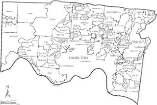
Kane County is a county in the U.S. state of Illinois. According to the 2020 census, it has a population of 516,522, making it the fifth-most populous county in Illinois. Its county seat is Geneva, and its largest city is Aurora. Kane County is one of the collar counties of the metropolitan statistical area designated "Chicago–Naperville–Elgin, IL–IN–WI" by the US census.

Wayne is a village in DuPage and Kane counties, Illinois, United States. The eastern portion, in DuPage County, is in Wayne Township, while the western portion, in Kane County, is in St. Charles Township. The population was 2,286 as of the 2020 census.

The Calumet River is a system of heavily industrialized rivers and canals in the region between the south side of Chicago, Illinois, and the city of Gary, Indiana. Historically, the Little Calumet River and the Grand Calumet River were one, the former flowing west from Indiana into Illinois, then turning back east to its mouth at Lake Michigan at Marquette Park in Gary. Now the system is part of the Chicago Area Waterway System and through the use of locks flows away from Lake Michigan to the Cal-Sag Channel.

Brown County State Park is located in the United States in the center of the southern half of the state of Indiana. The park is by far the largest of 24 state parks in Indiana, and occupies 15,776 acres (63.84 km2)—making it one of the larger state parks in the United States. It is among Indiana's most visited state parks with about 1.2 million visitors annually. Although Bloomington, Indiana, is the closest city, the park is closer to the small town of Nashville in Brown County. Brown County is named for General Jacob Brown, who fought in the War of 1812 and became Commanding General of the United States Army.
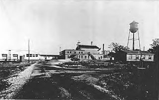
Site A was a research facility near Chicago where, during World War II, research on behalf of the Manhattan Project was carried out. Operated by the University of Chicago's Metallurgical Laboratory, it was the site of Chicago Pile-2, a reconstructed and enlarged version of the world's first nuclear reactor, Chicago Pile-1. The first heavy-water reactor, Chicago Pile-3, was also constructed at this site. Research was carried out under contract to the United States' Office of Scientific Research and Development. After the war, the site became the first home of Argonne National Laboratory, a federally funded research and development center.

Arastradero Preserve, officially known as Enid W. Pearson–Arastradero Preserve, is a 622 acres nature preserve that protects most of the Arastradero Creek watershed, including its ephemeral Mayfly Creek tributary. It also includes the upper reach of the Felt Creek tributary to Stanford's Felt Reservoir. The preserve is owned and operated by the City of Palo Alto, California. The main parking lot hosts an interpretive center and is located at 1530 Arastradero Road.

Three Rivers Park District is a special park district serving the suburban areas of the Twin Cities including suburban Hennepin, Carver, Dakota, Scott, and Ramsey counties. Three Rivers's mission is "To promote environmental stewardship through recreation and education in a natural resources-based park system." Three Rivers operates twenty parks and ten regional trails, with at least two more regional trails planned. Nearly seven million people visit Three Rivers facilities each year. It has over 27,000 acres (11,000 ha) of parks and trails.
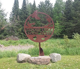
Moose Lake State Park is a state park of Minnesota, USA, near the city of Moose Lake, MN in Carlton County. The park is located one-half mile east of Interstate 35 at the 214 exit. The park entrance is off of County Highway 137. Moose Lake State Park was established in 1971. In total, the park is 1,194 acres in area. Some of the highlights of the park include 5.5 miles of hiking trails, a 105-acre Echo Lake, wildlife pond, paved trail to Moose Lake and Willard Munger State Trail, and Agate/Geological Interpretive Center; located within the park office.

Archer Avenue, sometimes known as Archer Road outside the Chicago, Illinois city limits, and also known as State Street only in Lockport, Illinois and Fairmont, Illinois city limits, is a street running northeast-to-southwest between Chicago's Chinatown and Lockport. Archer follows the original trail crossing the Chicago Portage between the Chicago River and the Des Plaines River, and parallels the path of the Illinois and Michigan Canal and the Alton Railroad. As a main traffic artery, it has largely been replaced by the modern Stevenson Expressway.
The Des Plaines River Trail is a recreational multiuse trail that follows the course of the Des Plaines River through most of Lake and part of Cook County in northeast Illinois in the United States. This trail connects with the North Branch Trail and Green Bay Trail.

The Forest Preserve District of Cook County is a governmental commission in Cook County, Illinois, that owns and manages land containing forest, prairie, wetland, streams, and lakes. These land holdings are primarily managed as undeveloped natural areas and for outdoor recreation. The Forest Preserve District encompasses approximately 70,000 acres of land or approximately 11% of the land in Cook County, which contains the city of Chicago and is the most densely populated urban metropolitan area in the Midwest. The Forest Preserves also owns the lands on which the Brookfield Zoo and the Chicago Botanic Garden operate.
The Forest Preserve District of DuPage County is a governmental agency headquartered in Wheaton, Illinois. Its mission is to acquire and hold lands containing forests, prairies, wetlands, and associated plant communities or lands capable of being restored to such natural conditions for the purpose of protecting and preserving the flora, fauna and scenic beauty for the education, pleasure and recreation of the citizens of DuPage County.

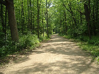
Red Gate Woods is a forest preserve section within the Palos Forest Preserve, a division of the Forest Preserve District of Cook County, Illinois. It is located near where the Cal-Sag Channel meets the Chicago Sanitary and Ship Canal. In the woods is the original site of Argonne National Laboratory and the Site A/Plot M Disposal Site, which contains the buried remains of Chicago Pile-1, the world's first artificial nuclear reactor.

Lemont Township is one of 29 townships in Cook County, Illinois, USA. As of the 2020 census, its population was 22,645 and it contained 8,580 housing units.

Palos Township is one of 29 townships in Cook County, Illinois. As of the 2020 census, its population was 56,836, with its most populous municipality being Palos Hills. The vast majority of the township's population resides in its eastern half; the half west of La Grange Road consists of the Palos Forest Preserves, a section of the Cook County Forest Preserves. In 1850 the small town of Trenton, Illinois changed its name to Palos; this recommendation was made by M.S. Powell, the local postmaster, whose ancestor supposedly sailed with Christopher Columbus from Palos de la Frontera. When it incorporated as a village in 1914, Palos officially became Palos Park. Nearby communities incorporated later: Hickory Hills, in 1951, and Palos Hills, in 1958. All three municipalities lie completely or substantially within Palos Township. Palos Heights, partially in Worth Township, incorporated in 1959.
The North Branch Trail is a Class I bicycle trail located in northeastern Cook County, Illinois. The trail starts at the western part of Gompers Park in Chicago, and from there it continues north approximately 22 miles (35 km) to Glencoe. The trail follows a path along the North Branch of the Chicago River, the Skokie River and the Skokie Lagoons.

Lake Hudson State Recreation Area is a public recreation area located within southwestern Lenawee County in the U.S. state of Michigan. With its main entrance located along M-156, it is mostly located within Hudson Township and a very small portion extending south into neighboring Medina Township.
Lake County Forest Preserves is a governmental organization that purchases land and oversees the use of such public open-space in Lake County, Illinois. It is a member of Chicago Wilderness.
Great Parks of Hamilton County is the park district of Hamilton County, Ohio, United States. It was established in 1930, opening its first park, Sharon Woods, in 1932. It was known as the Hamilton County Park District until 2014. The park system includes 18 parks and 4 conservation areas. It is governed by a board of park commissioners. Park headquarters are located in the second largest park in the system, Winton Woods. The county park system also coordinates with the Cincinnati Park Board.