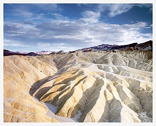
Death Valley National Park is an American national park that straddles the California–Nevada border, east of the Sierra Nevada. The park boundaries include Death Valley, the northern section of Panamint Valley, the southern section of Eureka Valley and most of Saline Valley. The park occupies an interface zone between the arid Great Basin and Mojave deserts, protecting the northwest corner of the Mojave Desert and its diverse environment of salt-flats, sand dunes, badlands, valleys, canyons and mountains. Death Valley is the largest national park in the contiguous United States, as well as the hottest, driest and lowest of all the national parks in the United States. It contains Badwater Basin, the second-lowest point in the Western Hemisphere and lowest in North America at 282 feet (86 m) below sea level. More than 93% of the park is a designated wilderness area. The park is home to many species of plants and animals that have adapted to this harsh desert environment including creosote bush, Joshua tree, bighorn sheep, coyote, and the endangered Death Valley pupfish, a survivor from much wetter times. UNESCO included Death Valley as the principal feature of its Mojave and Colorado Deserts Biosphere Reserve in 1984.

Death Valley is a desert valley in Eastern California, in the northern Mojave Desert, bordering the Great Basin Desert. During summer, it is the hottest place on Earth.

Inyo County is a county in the eastern central part of the U.S. state of California, located between the Sierra Nevada and the state of Nevada. In the 2020 census, the population was 19,016. The county seat is Independence. Inyo County is on the east side of the Sierra Nevada and southeast of Yosemite National Park in Central California. It contains the Owens River Valley; it is flanked to the west by the Sierra Nevada and to the east by the White Mountains and the Inyo Mountains. With an area of 10,192 square miles (26,397 km2), Inyo County is the second-largest county by area in California, after San Bernardino County. Almost one-half of that area is within Death Valley National Park. However, with a population density of 1.8 people per square mile, it also has the second-lowest population density in California, after Alpine County.

Darwin is an unincorporated mining community in Inyo County, California, United States. It is located 22 miles (35 km) southeast of Keeler, at an elevation of 4,790 ft (1,460 m). The population was 43 at the 2010 census, down from 54 at the 2000 census.

The Amargosa River is an intermittent waterway, 185 miles (298 km) long, in southern Nevada and eastern California in the United States. It drains a high desert region, the Amargosa Valley in the Amargosa Desert northwest of Las Vegas, into the Mojave Desert, and finally into Death Valley where it disappears into the ground aquifer. Except for a small portion of its route in the Amargosa Canyon in California and a small portion at Beatty, Nevada, the river flows above ground only after a rare rainstorm washes the region. A 26-mile (42 km) stretch of the river between Shoshone and Dumont Dunes is protected as a National Wild and Scenic River. At the south end of Tecopa Valley the Amargosa River Natural Area protects the habitat.
Places of interest in the Death Valley area are mostly located within Death Valley National Park in eastern California.

The Amargosa Range is a mountain range in Inyo County, California and Nye County, Nevada. The 110-mile (180 km) range runs along most of the eastern side of California's Death Valley, separating it from Nevada's Amargosa Desert. The U-shaped Amargosa River flows clockwise around the perimeter of the range, ending 282 feet (86 m) below sea level in the Badwater Basin.

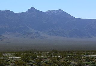
Panamint City is a ghost town in the Panamint Range, near Death Valley, in Inyo County, California, US. It is also known by the official Board of Geographic Names as Panamint. Panamint was a boom town founded after silver and copper were found there in 1872. By 1874, the town had a population of about 2,000. Its main street was one mile (1.6 km) long. Panamint had its own newspaper, the Panamint News. Silver was the principal product mined in the area. The town is located about three miles northwest of Sentinel Peak. According to the National Geographic Names Database, NAD27 latitude and longitude for the locale are 36°07′06″N117°05′43″W, and the feature ID number is 1661185. The elevation of this location is identified as being 6,280 feet AMSL. The similar-sounding Panamint Springs, California, is located about 25.8 miles at 306.4 degrees off true north near Panamint Junction.
The Timbisha are a Native American tribe federally recognized as the Death Valley Timbisha Shoshone Band of California. They are known as the Timbisha Shoshone Tribe and are located in south central California, near the Nevada border. As of the 2010 Census the population of the Village was 124. The older members still speak the ancestral language, also called Timbisha.
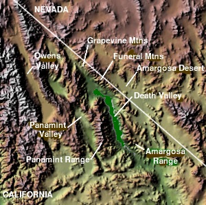
The Panamint Valley is a long basin located east of the Argus and Slate ranges, and west of the Panamint Range in the northeastern reach of the Mojave Desert, in eastern California, United States.

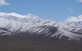
Telescope Peak is the highest point within Death Valley National Park, in the U.S. state of California. It is also the highest point of the Panamint Range, and lies in Inyo County. From atop this desert mountain one can see for over one hundred miles in many directions, including west to Mount Whitney, and east to Charleston Peak. The mountain was named for the great distance visible from the summit.

The Deserts of California have unique ecosystems and habitats, a sociocultural and historical "Old West" collection of legends, districts, and communities, and they also form a popular tourism region of dramatic natural features and recreational development. All of the deserts are located in eastern Southern California, in the Western United States.
Lookout City is a former settlement in the Mojave Desert, in Inyo County, California. It lay at an elevation of 3579 feet.
Reilly is a former settlement in Inyo County, California. It was located on the west side of the Panamint Valley, at an elevation of 2582 feet. Reilly was a silver mining community in the late 19th century.
The Nelson Range is a mountain range in the "Northern Mojave-Mono Lake region" of Inyo County, California, in Death Valley National Park.
The Lost Burro Formation is a Middle to Upper/Late Devonian geologic formation in the Mojave Desert of California in the Western United States.
Needle Peak is a mountain in the Panamint Range in the northern Mojave Desert, in Inyo County, eastern California.

Coso Peak is the highest summit in the Coso Range, a small mountain range east of the Sierra Nevada, in Inyo County in the U.S. state of California. The peak has an elevation of 8,157 feet and a topographic prominence of 2,489 ft (759 m), making it the 88th most prominent mountain in California.
Nopah Peak is the highest named peak in the Nopah Range, a mountain range in Inyo County, California, in the Mojave Desert just west of the state border with Nevada. The peak has an elevation of 6,365 feet and a topographic prominence of 628 ft (191 m). The peak boasts steep escarpments to both east and west, rising more than 3,000 ft (914 m) feet in approximately 0.75 miles from the desert floor of Chicago Valley to the west and nearly as steep a drop-off to the east.