A natural arch, natural bridge, or rock arch is a natural landform where an arch has formed with an opening underneath. Natural arches commonly form where inland cliffs, coastal cliffs, fins or stacks are subject to erosion from the sea, rivers or weathering.

A sinkhole is a depression or hole in the ground caused by some form of collapse of the surface layer. The term is sometimes used to refer to doline, enclosed depressions that are also known as shakeholes, and to openings where surface water enters into underground passages known as ponor, swallow hole or swallet. A cenote is a type of sinkhole that exposes groundwater underneath. Sink and stream sink are more general terms for sites that drain surface water, possibly by infiltration into sediment or crumbled rock.
Landforms are categorized by characteristic physical attributes such as their creating process, shape, elevation, slope, orientation, rock exposure, and soil type.
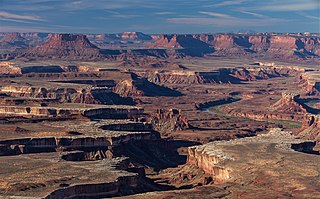
Canyonlands National Park is an American national park located in southeastern Utah near the town of Moab. The park preserves a colorful landscape eroded into numerous canyons, mesas, and buttes by the Colorado River, the Green River, and their respective tributaries. Legislation creating the park was signed into law by President Lyndon B. Johnson on September 12, 1964.

The exposed geology of the Yosemite area includes primarily granitic rocks with some older metamorphic rock. The first rocks were laid down in Precambrian times, when the area around Yosemite National Park was on the edge of a very young North American continent. The sediment that formed the area first settled in the waters of a shallow sea, and compressive forces from a subduction zone in the mid-Paleozoic fused the seabed rocks and sediments, appending them to the continent. Heat generated from the subduction created island arcs of volcanoes that were also thrust into the area of the park. In time, the igneous and sedimentary rocks of the area were later heavily metamorphosed.

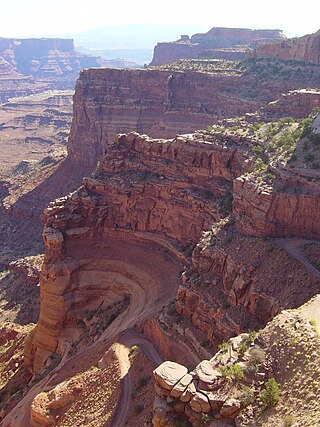
A mesa is an isolated, flat-topped elevation, ridge or hill, which is bounded from all sides by steep escarpments and stands distinctly above a surrounding plain. Mesas characteristically consist of flat-lying soft sedimentary rocks capped by a more resistant layer or layers of harder rock, e.g. shales overlain by sandstones. The resistant layer acts as a caprock that forms the flat summit of a mesa. The caprock can consist of either sedimentary rocks such as sandstone and limestone; dissected lava flows; or a deeply eroded duricrust. Unlike plateau, whose usage does not imply horizontal layers of bedrock, e.g. Tibetan Plateau, the term mesa applies exclusively to the landforms built of flat-lying strata. Instead, flat-topped plateaus are specifically known as tablelands.
The exposed geology of the Canyonlands area is complex and diverse; 12 formations are exposed in Canyonlands National Park that range in age from Pennsylvanian to Cretaceous. The oldest and perhaps most interesting was created from evaporites deposited from evaporating seawater. Various fossil-rich limestones, sandstones, and shales were deposited by advancing and retreating warm shallow seas through much of the remaining Paleozoic.

In structural geology, a syncline is a fold with younger layers closer to the center of the structure, whereas an anticline is the inverse of a syncline. A synclinorium is a large syncline with superimposed smaller folds. Synclines are typically a downward fold (synform), termed a synformal syncline, but synclines that point upwards can be found when strata have been overturned and folded.

A slot canyon is a long, narrow channel or drainageway with sheer rock walls that are typically eroded into either sandstone or other sedimentary rock. A slot canyon has depth-to-width ratios that typically exceed 10:1 over most of its length and can approach 100:1. The term is especially used in the semiarid southwestern United States and particularly the Colorado Plateau. Slot canyons are subject to flash flooding and commonly contain unique ecological communities that are distinct from the adjacent, drier uplands. Some slot canyons can measure less than 1 metre (3 ft) across at the top but drop more than 30 metres (100 ft) to the floor of the canyon.

Interstate Park comprises two adjacent state parks on the Minnesota–Wisconsin border, both named Interstate State Park. They straddle the Dalles of the St. Croix River, a deep basalt gorge with glacial potholes and other rock formations. The Wisconsin park is 1,330 acres (538 ha) and the Minnesota park is 298 acres (121 ha). The towns of Taylors Falls, Minnesota and St. Croix Falls, Wisconsin are adjacent to the park. Interstate Park is within the Saint Croix National Scenic Riverway and the Ice Age National Scientific Reserve. The western terminus of the Ice Age National Scenic Trail is on the Wisconsin side. On the Minnesota side, two areas contain National Park Service rustic style buildings and structures that are listed on the National Register of Historic Places.

Exfoliation joints or sheet joints are surface-parallel fracture systems in rock, often leading to the erosion of concentric slabs.

Carboniferous Limestone is a collective term for the succession of limestones occurring widely throughout Great Britain and Ireland that were deposited during the Dinantian Epoch of the Carboniferous Period. These rocks formed between 363 and 325 million years ago. Within England and Wales, the entire limestone succession, which includes subordinate mudstones and some thin sandstones, is known as the Carboniferous Limestone Supergroup.

In geology and geomorphology, a tessellated pavement is a relatively flat rock surface that is subdivided into polygons by fractures, frequently systematic joints, within the rock. This type of rock pavement bears this name because it is fractured into polygonal blocks that resemble tiles of a mosaic floor, or tessellations.

The Canyons of the Escalante is a collective name for the erosional landforms created by the Escalante River and its tributaries—the Escalante River Basin. Located in southern Utah in the western United States, these sandstone features include high vertical canyon walls, numerous slot canyons, waterpockets, domes, hoodoos, natural arches and bridges. This area—extending over 1,500 square miles (3,885 km2) and rising in elevation from 3,600 ft (1,097 m) to over 11,000 ft (3,353 m)—is one of the three main sections of the Grand Staircase–Escalante National Monument, and also a part of the Glen Canyon National Recreation Area, with Capitol Reef National Park being adjacent to the east.

Case hardening is a weathering phenomenon of rock surface induration. It is observed commonly in: felsic alkaline rocks, such as nepheline syenite, phonolite and trachyte; pyroclastic rocks, as pyroclastic flow deposit, fine air-fall deposits and vent-filling pyroclastic deposits; sedimentary rocks, as sandstone and mudstone.

Honeycomb weathering, also known as honeycombs, honeycombed sandstone, is a form of cavernous weathering that consists of regular, tightly adjoining, and commonly patterned cavities that are developed in weathered bedrock; are less than 2 cm (0.79 in) in size; and resemble a honeycombed structure. Honeycombs also been called alveoli, lacework, stonelace, fretting, or miniature tafoni weathering. The size at which honeycombs are differentiated from tafoni varies greatly in the scientific literature and lacks an official consensus.
A pothole is a surface disruption in a roadway, caused by fatigue and erosion.

In Earth science, a pothole is a smooth, bowl-shaped or cylindrical hollow, generally deeper than wide, found carved into the rocky bed of a watercourse. Other names used for riverine potholes are pot, (stream) kettle, giant's kettle, evorsion, hollow, rock mill, churn hole, eddy mill, and kolk. Although somewhat related to a pothole in origin, a plunge pool is the deep depression in a stream bed at the base of a waterfall. It is created by the erosional forces of turbulence generated by water falling on rocks at a waterfall's base where the water impacts. Potholes are also sometimes referred to as swirlholes. This word was created to avoid confusion with an English term for a vertical or steeply inclined karstic shaft in limestone. However, given widespread usage of this term for a type of fluvial sculpted bedrock landform, pothole is preferred in usage to swirlhole.

Considered the biggest rock in the world, Mount Augustus is located roughly 1,000 km north of Perth, in the Mount Augustus National Park in Western Australia. The name is also given to the neighbouring pastoral lease, Mount Augustus Station. The local Wadjari people call it Burringurrah, after a Dreamtime figure, a young boy who was speared and turned into a rock. It has been a sacred site for thousands of years.
Exfoliating granite is a granite undergoing exfoliation, or onion skin weathering (desquamation). The external delaminated layers of granite are gradually produced by the cyclic variations of temperature at the surface of the rock in a process also called spalling. Frost and ice expansion in the joints during the winter accelerate the alteration process while the most unstable loosen external layers are removed by gravity assisted by runoff water.