Related Research Articles
Maritime archaeology is a discipline within archaeology as a whole that specifically studies human interaction with the sea, lakes and rivers through the study of associated physical remains, be they vessels, shore-side facilities, port-related structures, cargoes, human remains and submerged landscapes. A specialty within maritime archaeology is nautical archaeology, which studies ship construction and use.
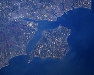
The Solent is a strait between the Isle of Wight and Great Britain. It is about 20 miles long and varies in width between 2+1⁄2 and 5 mi, although the Hurst Spit which projects 1+1⁄2 mi (2.4 km) into the Solent narrows the sea crossing between Hurst Castle and Colwell Bay to just over 1 mi (1.6 km).
Underwater archaeology is archaeology practiced underwater. As with all other branches of archaeology, it evolved from its roots in pre-history and in the classical era to include sites from the historical and industrial eras. Its acceptance has been a relatively late development due to the difficulties of accessing and working underwater sites, and because the application of archaeology to underwater sites initially emerged from the skills and tools developed by shipwreck salvagers. As a result, underwater archaeology initially struggled to establish itself as actual archaeological research. This changed when universities began teaching the subject and a theoretical and practical base for the sub-discipline was firmly established in the late 1980’s. Underwater archaeology now has a number of branches including, maritime archaeology: the scientifically based study of past human life, behaviours and cultures and their activities in, on, around and (lately) under the sea, estuaries and rivers. This is most often effected using the physical remains found in, around or under salt or fresh water or buried beneath water-logged sediment. In recent years, the study of submerged WWII sites and of submerged aircraft in the form of underwater aviation archaeology have also emerged as bona fide activity.
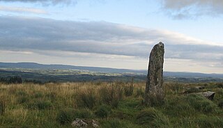
A menhir, standing stone, orthostat, or lith is a large human-made upright stone, typically dating from the European middle Bronze Age. They can be found individually as monoliths, or as part of a group of similar stones. Menhirs' size can vary considerably, but they often taper toward the top.

A megalith is a large stone that has been used to construct a prehistoric structure or monument, either alone or together with other stones. There are over 35,000 in Europe alone, located widely from Sweden to the Mediterranean sea.

Pantelleria, the ancient Cossyra or Cossura, is an Italian island and comune in the Strait of Sicily in the Mediterranean Sea, 100 kilometres southwest of Sicily and 60 km (30 nmi) east of the Tunisian coast. On clear days Tunisia is visible from the island. Administratively Pantelleria's comune belongs to the Sicilian province of Trapani.

The Strait of Sicily is the strait between Sicily and Tunisia. The strait is about 145 kilometres (90 mi) wide and divides the Tyrrhenian Sea and the western Mediterranean Sea, from the eastern Mediterranean Sea. The maximum depth is 316 meters (1,037 ft).

Franchthi Cave or Frankhthi Cave is an archaeological site overlooking Kiladha Bay, in the Argolic Gulf, opposite the village of Kiladha in southeastern Argolis, Greece.

The Cosquer Cave is located in the Calanque de Morgiou in Marseille, France, near Cap Morgiou. The entrance to the cave is located 37 m (121 ft) underwater, due to the Holocene sea level rise. The cave contains various prehistoric rock art engravings. Its submarine entrance was discovered in 1985 by Henri Cosquer, a professional diver. The underwater passage leading to the cave was progressively explored till 1990 by cave divers without the divers being aware of the archaeological character of the cave. It is only in the last period (1990-1991) of the progressive underwater explorations that the cave divers emerged in the non-submerged part of the cave. The prehistoric paintings were not immediately discovered by the divers to first emerge from the other side of the sump. The cave was named after Henri Cosquer, when its existence was made public in 1991, after that three divers became lost in the cave and died.

The Yonaguni Monument, also known as "Yonaguni (Island) Submarine Ruins", is a submerged rock formation off the coast of Yonaguni, the southernmost of the Ryukyu Islands, in Japan. It lies approximately a hundred kilometres east of Taiwan.

Fagnano Lake, also called Lake Cami, is a lake located on the main island of the Tierra del Fuego archipelago, and shared by Argentina and Chile. The 645 km2 lake runs east–west for about 98 kilometres, of which 72.5 km (606 km2) belong to the Argentine Tierra del Fuego Province, and only 13.5 km (39 km2) belong to the Chilean Magallanes y la Antártica Chilena Region. It has a maximum depth of 449 meters. The southern bank is steep compared to the northern, and expands in a considerably wide and flat piedmont from which both levels of the plateaus can be appreciated. From its western end, the Azopardo River drains towards the Almirantazgo Fjord. On its eastern end is the town of Tolhuin. The lake is located in a pull-apart basin developed along the Magallanes–Fagnano Fault zone.

The archaeology of shipwrecks is the field of archaeology specialized most commonly in the study and exploration of shipwrecks. Its techniques combine those of archaeology with those of diving to become Underwater archaeology. However, shipwrecks are discovered on what have become terrestrial sites.
Franck Goddio is a French underwater archaeologist who, in 2000, discovered the city of Thonis-Heracleion 7 km off the Egyptian shore in Aboukir Bay. He led the excavation of the submerged site of Eastern Canopus and of Antirhodos in the ancient harbour of Alexandria. He has also excavated ships in the waters of the Philippines, significantly the Spanish galleon San Diego.
This article describes several characteristic architectural elements typical of European megalithic structures.

Doggerland was an area of land, now submerged beneath the North Sea, that connected Britain to continental Europe. It was flooded by rising sea levels around 6500–6200 BCE. The flooded land is known as the Dogger Littoral. Geological surveys have suggested that it stretched from what is now the east coast of Great Britain to what are now the Netherlands, the western coast of Germany and the Danish peninsula of Jutland. It was probably a rich habitat with human habitation in the Mesolithic period, although rising sea levels gradually reduced it to low-lying islands before its final submergence, possibly following a tsunami caused by the Storegga Slide. Doggerland was named after the Dogger Bank, which in turn was named after 17th-century Dutch fishing boats called doggers.
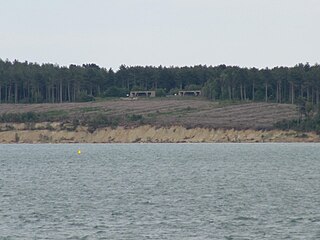
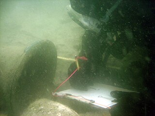
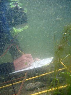
Bouldnor Cliff is a submerged prehistoric settlement site in the Solent. The site dates from the Mesolithic era and is in approximately 11 metres (12 yd) of water just offshore of the village of Bouldnor on the Isle of Wight in the United Kingdom. The preservation of organic materials from this era that do not normally survive on dry land has made Bouldnor important to the understanding of Mesolithic Britain, and the BBC Radio 4's Making History programme described it "probably Europe's most important Mesolithic site" albeit concealed under water.
Michael Alexander Arbuthnot is an archaeologist, instructor and archaeological filmmaker.
An unidentified submerged object (USO) is an unidentified object submerged in water. The term does not necessarily refer to an object of paranormal origin.
Zvi Ben-Avraham is an Israeli earth scientist, specializing in geophysics of the Mediterranean Sea and the Dead Sea Transform. He is currently a professor of Geophysics at Tel Aviv University. Ben-Avraham was awarded the Israel Prize in 2003. He is member of several national academies and fellow of geological societies.

The Gozo Phoenician shipwreck is a seventh-century-BC shipwreck of a Phoenician trade ship lying at a depth of 110 meters (360 ft). The wreck was discovered in 2007 by a team of French scientists during a sonar survey off the coast of Malta's Gozo island. The Gozo shipwreck archaeological excavation is the first maritime archaeological survey to explore shipwrecks beyond a depth of 100 meters (330 ft).
References
- ↑ "9,300-Year-Old Stonehenge-Style Monolith Found in Mediterranean Sea | Archaeology | Sci-News.com". Sci.News: Breaking Science News. 2015-08-12. Retrieved 2022-09-14.
- 1 2 Lodolo, Emanuele; Ben-Avraham, Zvi (September 2015). "A submerged monolith in the Sicilian Channel (central Mediterranean Sea): Evidence for Mesolithic human activity". Journal of Archaeological Science: Reports. 3: 398–407. doi:10.1016/j.jasrep.2015.07.003.
- 1 2 Laura Geggel (August 13, 2015). "Ancient Monolith Suggests Humans Lived on Now-Underwater Archipelago".
- ↑ Gemma Tarlach (November 30, 2015). "Mysterious Monolith in the Sicilian Channel". Discover.
- ↑ "Monolith Discovered in the Sicilian Channel". Archaeology Magazine. August 7, 2015.