
The Port Authority of New York and New Jersey, is a joint venture between the U.S. states of New York and New Jersey, established in 1921 through an interstate compact authorized by the United States Congress. The Port Authority oversees much of the regional transportation infrastructure, including bridges, tunnels, airports, and seaports, within the geographical jurisdiction of the Port of New York and New Jersey. This 1,500-square-mile (3,900 km2) port district is generally encompassed within a 25-mile (40 km) radius of the Statue of Liberty National Monument. The Port Authority is headquartered at 4 World Trade Center in Lower Manhattan.

The Port Authority Trans-Hudson (PATH) is a 13.8-mile (22.2 km) rapid transit system in the northeastern New Jersey cities of Newark, Harrison, Jersey City, and Hoboken, as well as Lower and Midtown Manhattan in New York City. It is operated as a wholly owned subsidiary of the Port Authority of New York and New Jersey. PATH trains run around the clock year-round; four routes serving 13 stations operate during the daytime on weekdays, while two routes operate during weekends, late nights, and holidays. It crosses the Hudson River through cast iron tunnels that rest on the river bottom. It operates as a deep-level subway in Manhattan and the Jersey City/Hoboken riverfront; from Grove Street in Jersey City to Newark, trains run in open cuts, at grade level, and on elevated track. In 2023, the system saw 55,109,100 rides, or about 187,000 per weekday in the fourth quarter of 2023.

Newark Penn Station is an intermodal passenger station in Newark, New Jersey. One of the New York metropolitan area's major transportation hubs, Newark Penn Station is served by multiple rail and bus carriers, making it the seventh busiest rail station in the United States, and the fourth busiest in the New York City metropolitan area.

For the purposes of this article, the Jersey City area extends North to Edgewater, South to Bayonne and includes Kearny Junction and Harrison but not Newark. Many routes east of Newark are listed here.

Manhattan Transfer was a passenger transfer station in Harrison, New Jersey, east of Newark, 8.8 miles (14.2 km) west of New York Penn Station on the Pennsylvania Railroad (PRR) main line, now Amtrak's Northeast Corridor. It operated from 1910 to 1937 and consisted of two 1,100 feet (340 m) car-floor-level platforms, one on each side of the PRR line. It was also served by the Hudson and Manhattan Railroad. There were no pedestrian entrances or exits to the station, as its sole purpose was for passengers to change trains, or for trains to have their locomotives changed.

The Journal Square Transportation Center is a multi-modal transportation hub located on Magnolia Avenue and Kennedy Boulevard at Journal Square in Jersey City, New Jersey, United States. Owned and operated by the Port Authority of New York and New Jersey, the complex includes a ten-story tower, a retail plaza, a bus terminal, a two-level parking facility, and the Journal Square station of the PATH rail transit system. The underground station has a high ceiling and a mezzanine level connecting the platforms.

Harrison station is a station on the PATH system. Located on Frank E. Rodgers Boulevard between I-280 and the Passaic River in Harrison, New Jersey, it is served by the Newark–World Trade Center line at all times.
Exchange Place is a district of Downtown Jersey City, New Jersey that is sometimes referred to as Wall Street West due to the concentration of financial companies that have offices there. The namesake is a square, about 200 feet long, at the foot of Montgomery Street at the waterfront of the Hudson River. This square was created by landfilling the shore at Paulus Hook, and has been a major transportation hub since the colonial era.
Route 158 was a short state highway in Newark and Harrison, New Jersey, in the counties of Essex and Hudson, which are located in the United States. The Centre Street Bridge was first constructed in 1834 as a single-level railroad bridge. However, in 1911, almost eight decades later, a second, upper level was constructed for rapid transit. In 1937, the Hudson and Manhattan Railroad, now part of the Port Authority Trans-Hudson line, was realigned onto railroad tracks along New Jersey Route 21. The upper level of the bridge was abandoned for this purpose, and was later converted to roadway. At the western end in Newark it ran just south of Park Place, beginning at Center Street. The route headed eastward, crossing over Route 21 and the Passaic River before entering Harrison, where it terminated at Second Street north of New Jersey Railroad Avenue.

The Pennsylvania Railroad Station was the intermodal passenger terminal for the Pennsylvania Railroad's (PRR) vast holdings on the Hudson River and Upper New York Bay in Jersey City, New Jersey. By the 1920s the station was called Exchange Place. The rail terminal and its ferry slips were the main New York City station for the railroad until the opening in 1910 of New York Pennsylvania Station, made possible by the construction of the North River Tunnels. It was one of the busiest stations in the world for much of the 19th century.

Exchange Place station is a station on the Port Authority Trans–Hudson (PATH) rail system in the Paulus Hook neighborhood of Jersey City, Hudson County, New Jersey. The station is on the Newark–World Trade Center line between Newark Penn Station and World Trade Center all week and the Hoboken–World Trade Center line during the day on weekdays to service Hoboken Terminal. Exchange Place provides access to the Jersey City waterfront and a station on the Hudson–Bergen Light Rail, where connections are available to Bayonne and North Bergen.

World Trade Center station is a terminal station on the PATH system, within the World Trade Center complex in the Financial District of Manhattan, New York City. It is served by the Newark–World Trade Center line at all times, as well as by the Hoboken–World Trade Center line on weekdays, and is the eastern terminus of both.

Journal Square–33rd Street is a rapid transit service operated by the Port Authority Trans-Hudson (PATH). It is colored yellow on the PATH service map and trains on this service display yellow marker lights. This service operates from Journal Square in Jersey City, New Jersey by way of the Uptown Hudson Tubes to 33rd Street in Midtown Manhattan, New York. The 5.7-mile (9.2 km) trip takes 22 minutes to complete.

Hoboken–World Trade Center is a rapid transit service operated by the Port Authority Trans-Hudson (PATH). It is colored green on the PATH service map and trains on this service display green marker lights. This service operates from the Hoboken Terminal in Hoboken, New Jersey, by way of the Downtown Hudson Tubes to the World Trade Center in Lower Manhattan, New York. The 3-mile (4.8 km) trip takes 11 minutes to complete, and is the shortest route in the PATH system.

Hoboken–33rd Street is a rapid transit service operated by the Port Authority Trans-Hudson (PATH). It is colored blue on the PATH service map and trains on this service display blue marker lights. This service operates from the Hoboken Terminal in Hoboken, New Jersey by way of the Uptown Hudson Tubes to 33rd Street in Midtown Manhattan, New York. The 3.5-mile (5.6 km) trip takes 14 minutes to complete.

Newark–World Trade Center is a rapid transit service operated by the Port Authority Trans-Hudson (PATH). It is colored red on the PATH service map and trains on this service display red marker lights. This service operates from Pennsylvania Station in Newark, New Jersey, by way of the Downtown Hudson Tubes to the World Trade Center in Lower Manhattan, New York City, New York. Operating 24 hours a day, the 8.9-mile (14.3 km) trip takes 22+1⁄2 minutes to complete.

33rd Street station is a terminal station on the PATH system. Located at the intersection of 32nd Street and Sixth Avenue in the Herald Square neighborhood of Midtown Manhattan, New York City, it is served by the Hoboken–33rd Street and Journal Square–33rd Street lines on weekdays, and by the Journal Square–33rd Street line on late nights, weekends and holidays. 33rd Street serves as the northern terminus of all three lines.

The Downtown Hudson Tubes are a pair of tunnels that carry PATH trains under the Hudson River in the United States, between New York City to the east and Jersey City, New Jersey, to the west. The tunnels run between the World Trade Center station on the New York side and the Exchange Place station on the New Jersey side.

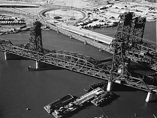
Dock Bridge is a pair of vertical lift bridges crossing the Passaic River at Newark, Essex County and Harrison, Hudson County, New Jersey, United States, used exclusively for railroad traffic. It is the seventh crossing from the river's mouth at Newark Bay and is 5.0 miles (8.0 km) upstream from it. Also known as the Amtrak Dock Vertical Lift, it carries Amtrak, NJ Transit, and PATH trains. It is listed on the state and federal registers of historic places.
The PATH Lift is a lift bridge carrying the Port Authority Trans-Hudson (PATH) rapid transit line across the Hackensack River between Kearny and Jersey City, New Jersey. It is used by PATH trains going to and from Newark.


