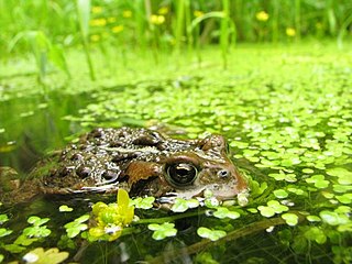
Ecology is the natural science of the relationships among living organisms, including humans, and their physical environment. Ecology considers organisms at the individual, population, community, ecosystem, and biosphere level. Ecology overlaps with the closely related sciences of biogeography, evolutionary biology, genetics, ethology, and natural history.

Soil erosion is the denudation or wearing away of the upper layer of soil. It is a form of soil degradation. This natural process is caused by the dynamic activity of erosive agents, that is, water, ice (glaciers), snow, air (wind), plants, and animals. In accordance with these agents, erosion is sometimes divided into water erosion, glacial erosion, snow erosion, wind (aeolian) erosion, zoogenic erosion and anthropogenic erosion such as tillage erosion. Soil erosion may be a slow process that continues relatively unnoticed, or it may occur at an alarming rate causing a serious loss of topsoil. The loss of soil from farmland may be reflected in reduced crop production potential, lower surface water quality and damaged drainage networks. Soil erosion could also cause sinkholes.

Landscape ecology is the science of studying and improving relationships between ecological processes in the environment and particular ecosystems. This is done within a variety of landscape scales, development spatial patterns, and organizational levels of research and policy. Concisely, landscape ecology can be described as the science of "landscape diversity" as the synergetic result of biodiversity and geodiversity.

Ecological succession is the process of change in the species that make up an ecological community over time.
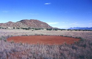
Fairy circles are circular patches of land barren of plants, varying between 2 and 12 metres in diameter, often encircled by a ring of stimulated growth of grass. They occur in the arid grasslands of the Namib desert in western parts of Southern Africa, and in a part of the Pilbara in Western Australia. Studies have posited various hypotheses about their origins, but none have conclusively proven how they are formed. Theories include the activities of various types of termites, or the consequence of vegetation patterns that arise naturally from competition between grasses.

An ecosystem engineer is any species that creates, significantly modifies, maintains or destroys a habitat. These organisms can have a large impact on species richness and landscape-level heterogeneity of an area. As a result, ecosystem engineers are important for maintaining the health and stability of the environment they are living in. Since all organisms impact the environment they live in one way or another, it has been proposed that the term "ecosystem engineers" be used only for keystone species whose behavior very strongly affects other organisms.

Habitat fragmentation describes the emergence of discontinuities (fragmentation) in an organism's preferred environment (habitat), causing population fragmentation and ecosystem decay. Causes of habitat fragmentation include geological processes that slowly alter the layout of the physical environment, and human activity such as land conversion, which can alter the environment much faster and causes the extinction of many species. More specifically, habitat fragmentation is a process by which large and contiguous habitats get divided into smaller, isolated patches of habitats.

The intermediate disturbance hypothesis (IDH) suggests that local species diversity is maximized when ecological disturbance is neither too rare nor too frequent. At low levels of disturbance, more competitive organisms will push subordinate species to extinction and dominate the ecosystem. At high levels of disturbance, due to frequent forest fires or human impacts like deforestation, all species are at risk of going extinct. According to IDH theory, at intermediate levels of disturbance, diversity is thus maximized because species that thrive at both early and late successional stages can coexist. IDH is a nonequilibrium model used to describe the relationship between disturbance and species diversity. IDH is based on the following premises: First, ecological disturbances have major effects on species richness within the area of disturbance. Second, interspecific competition results in one species driving a competitor to extinction and becoming dominant in the ecosystem. Third, moderate ecological scale disturbances prevent interspecific competition.
Spatial ecology studies the ultimate distributional or spatial unit occupied by a species. In a particular habitat shared by several species, each of the species is usually confined to its own microhabitat or spatial niche because two species in the same general territory cannot usually occupy the same ecological niche for any significant length of time.

Mima mounds are low, flattened, circular to oval, domelike, natural mounds that are composed of loose, unstratified, often gravelly sediment that is an overthickened A horizon. These mounds range in diameter from 3 m (9.8 ft) to more than 50 m (160 ft); in height 30 cm (12 in) to greater than 2 m (6.6 ft); and in density from several to greater than 50 mounds per hectare, at times forming conspicuous natural patterns. Mima mounds can be seen at the Mima Mounds Natural Area Preserve in Washington state.

The science of pattern formation deals with the visible, (statistically) orderly outcomes of self-organization and the common principles behind similar patterns in nature.

In ecology, a disturbance is a temporary change in environmental conditions that causes a pronounced change in an ecosystem. Disturbances often act quickly and with great effect, to alter the physical structure or arrangement of biotic and abiotic elements. A disturbance can also occur over a long period of time and can impact the biodiversity within an ecosystem.
Patch dynamics is an ecological perspective that the structure, function, and dynamics of ecological systems can be understood through studying their interactive patches. Patch dynamics, as a term, may also refer to the spatiotemporal changes within and among patches that make up a landscape. Patch dynamics is ubiquitous in terrestrial and aquatic systems across organizational levels and spatial scales. From a patch dynamics perspective, populations, communities, ecosystems, and landscapes may all be studied effectively as mosaics of patches that differ in size, shape, composition, history, and boundary characteristics.
A fire regime is the pattern, frequency, and intensity of the bushfires and wildfires that prevail in an area over long periods of time. It is an integral part of fire ecology, and renewal for certain types of ecosystems. A fire regime describes the spatial and temporal patterns and ecosystem impacts of fire on the landscape, and provides an integrative approach to identifying the impacts of fire at an ecosystem or landscape level. If fires are too frequent, plants may be killed before they have matured, or before they have set sufficient seed to ensure population recovery. If fires are too infrequent, plants may mature, senesce, and die without ever releasing their seed.
Landscape limnology is the spatially explicit study of lakes, streams, and wetlands as they interact with freshwater, terrestrial, and human landscapes to determine the effects of pattern on ecosystem processes across temporal and spatial scales. Limnology is the study of inland water bodies inclusive of rivers, lakes, and wetlands; landscape limnology seeks to integrate all of these ecosystem types.
In ecology, a priority effect refers to the impact that a particular species can have on community development as a result of its prior arrival at a site. There are two basic types of priority effects: inhibitory and facilitative. An inhibitory priority effect occurs when a species that arrives first at a site negatively affects a species that arrives later by reducing the availability of space or resources. In contrast, a facilitative priority effect occurs when a species that arrives first at a site alters abiotic or biotic conditions in ways that positively affect a species that arrives later. Inhibitory priority effects have been documented more frequently than facilitative priority effects. Studies indicate that both abiotic and biotic factors can affect the strength of priority effects. Priority effects are a central and pervasive element of ecological community development that have significant implications for natural systems and ecological restoration efforts.

Fog drip is water dripping to the ground during fog. It occurs when water droplets from the fog adhere to the needles or leaves of trees or other objects, coalesce into larger drops and then drop to the ground.

Montane ecosystems are found on the slopes of mountains. The alpine climate in these regions strongly affects the ecosystem because temperatures fall as elevation increases, causing the ecosystem to stratify. This stratification is a crucial factor in shaping plant community, biodiversity, metabolic processes and ecosystem dynamics for montane ecosystems. Dense montane forests are common at moderate elevations, due to moderate temperatures and high rainfall. At higher elevations, the climate is harsher, with lower temperatures and higher winds, preventing the growth of trees and causing the plant community to transition to montane grasslands and shrublands or alpine tundra. Due to the unique climate conditions of montane ecosystems, they contain increased numbers of endemic species. Montane ecosystems also exhibit variation in ecosystem services, which include carbon storage and water supply.

Pyrogeography is the study of the past, present, and projected distribution of wildfire. Wildland fire occurs under certain conditions of climate, vegetation, topography, and sources of ignition, such that it has its own biogeography, or pattern in space and time. The earliest published evidence of the term appears to be in the mid-1990s, and the meaning was primarily related to mapping fires The current understanding of pyrogeography emerged in the 2000s as a combination of biogeography and fire ecology, facilitated by the availability of global-scale datasets of fire occurrence, vegetation cover, and climate. Pyrogeography has also been placed at the juncture of biology, the geophysical environment, and society and cultural influences on fire.
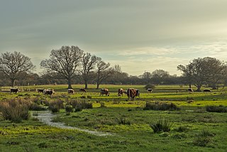
The wood-pasture hypothesis is a scientific hypothesis positing that open and semi-open pastures and wood-pastures formed the predominant type of landscape in post-glacial temperate Europe, rather than the common belief of primeval forests. The hypothesis proposes that such a landscape would be formed and maintained by large wild herbivores. Although others, including landscape ecologist Oliver Rackham, had previously expressed similar ideas, it was the Dutch researcher Frans Vera, who, in his 2000 book Grazing Ecology and Forest History, first developed a comprehensive framework for such ideas and formulated them into a theorem. Vera's proposals, although highly controversial, came at a time when the role grazers played in woodlands was increasingly being reconsidered, and are credited for ushering in a period of increased reassessment and interdisciplinary research in European conservation theory and practice. Although Vera largely focused his research on the European situation, his findings could also be applied to other temperate ecological regions worldwide, especially the broadleaved ones.


