Suffolk County is the easternmost county in the U.S. state of New York. It comprises the eastern two-thirds of Long Island, bordered to its west by Nassau County, to its east by Gardiners Bay and the Atlantic Ocean, to its north by Long Island Sound, and to its south by Great South Bay.

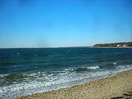
Hampton Bays is a hamlet and census-designated place (CDP) in the Town of Southampton in Suffolk County, on Long Island, in New York. It is considered as part of the region of Long Island known as The Hamptons. The population was 13,603 at the 2010 census.

Long Island Sound is a marine sound and tidal estuary of the Atlantic Ocean. It lies predominantly between the U.S. state of Connecticut to the north and Long Island in New York to the south. From west to east, the sound stretches 110 mi (180 km) from the East River in New York City, along the North Shore of Long Island, to Block Island Sound. A mix of freshwater from tributaries, and saltwater from the Atlantic Ocean, Long Island Sound is 21 mi (34 km) at its widest point and varies in depth from 65 to 230 feet.

Southampton, officially the Town of Southampton, is a town in southeastern Suffolk County, New York, partly on the South Fork of Long Island. As of the 2020 U.S. census, the town had a population of 69,036. Southampton is included in the stretch of shoreline prominently known as The Hamptons.

The Town of Southold is one of ten towns in Suffolk County, New York, United States. It is located in the northeastern tip of the county, on the North Fork of Long Island. The population was 23,732 at the 2020 census. The town also contains a hamlet named Southold, which was settled in 1640.

Gardiners Bay is a small arm of the Atlantic Ocean, approximately 10 mi (16 km) long and 8 mi (13 km) wide in the U.S. state of New York between the two flukelike peninsulas at the eastern end of Long Island. It is bounded on its eastern end, where it connects to Block Island Sound, by Gardiners Island and Promised Land.

The Mullica River is a 50.6-mile-long (81.4 km) river in southern New Jersey in the United States. The Mullica was once known as the Little Egg Harbor River.

Peconic County is a proposed new county on Long Island in the U.S. state of New York that would secede the five easternmost towns of Suffolk County: East Hampton, Riverhead, Shelter Island, Southampton and Southold, plus the Shinnecock Indian Reservation.

The North Fork is a 30-mile- (48 km) long peninsula in the northeast part of Suffolk County, New York, U.S., roughly parallel with a longer peninsula known as the South Fork, both on the East End of Long Island. Although the peninsula begins east of Riverhead hamlet, the term North Fork can also refer collectively to the towns of Riverhead and Southold in their entirety.
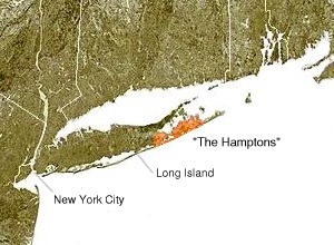
The South Fork of Suffolk County, New York is a peninsula in the southeastern section of the county on the South Shore of Long Island. The South Fork includes most of the Hamptons. The shorter, more northerly peninsula is known as the North Fork.

The Shinnecock Canal is a canal that cuts across the South Fork at Hampton Bays, New York. At 4,700 feet (1,400 m) long, it connects Great Peconic Bay and the north fork of Long Island with Shinnecock Bay and the Atlantic Ocean. The canal opened to traffic in 1892.

New York's 1st congressional district is a congressional district for the United States House of Representatives in eastern Long Island. It includes the eastern two-thirds of Suffolk County, including the northern portion of Brookhaven, as well as the entirety of the towns of Huntington, Smithtown, Riverhead, Southold, Southampton, East Hampton, and Shelter Island. The district encompasses extremely wealthy enclaves such as the Hamptons, middle class suburban towns such as Selden, Centereach and Lake Grove, working-class towns such as Riverhead and rural farming communities such as Mattituck and Jamesport on the North Fork. The district currently is represented by Republican Nick LaLota.
Bonackers is the name for a group of people from the East Hampton Town area of East Hampton, New York.
The South Shore Estuary is an estuary located along the south shore of Long Island, between the mainland and the outer barrier islands, in eastern New York state. It stretches for over 70 miles (110 km) from West Bay in Nassau County to the Shinnecock Bay in Suffolk County.

Moriches Bay is a lagoon system on the south shore of Long Island, New York. The name Moriches comes from Meritces, a Native American who owned land on Moriches Neck.
Canoe Place was a station stop along the Montauk Branch of the Long Island Rail Road and first opened as a low cinder platform on the south east side of Shinnecock Canal in 1935. The station was in service for "Fisherman's Special" trains and was closed in 1953. "Fisherman's Special" trains operated from Penn Station to Montauk and provided an intermediate stop at Canoe Place for boats waiting to take anglers out on Peconic Bay. The station was located between Hampton Bays and Suffolk Downs Stations. The hamlet where it was located is now part of Hampton Bays, New York.

The East End of Long Island is constituted by the five townships at the eastern end of New York's Suffolk County, namely Riverhead, Southampton, Southold, Shelter Island, and East Hampton. Long Island's North Fork and South Fork are part of the East End. "The East End" is sometimes shortened as "The End", but this latter term is also applied only to Montauk, the most easterly hamlet of the contiguous land mass.
The Tide Mill at Southold, erected in the 1640's by Thomas Benedict, holds a place of distinction in American history as the first recorded English mill in the New World. It paved the way for future tide mills and contributed to the economic growth of the Southold community..