Related Research Articles

Pelham is a suburban town in Westchester County, approximately 10 miles northeast of Midtown Manhattan. As of the 2020 census, it had a population of 13,078, an increase from the 2010 census. Historically, Pelham was composed of five villages and became known as "the Pelhams". Pelham currently contains two independently incorporated villages: the Villages of Pelham and Pelham Manor.

Throggs Neck is a neighborhood and peninsula in the south-eastern portion of the borough of the Bronx in New York City. It is bounded by the East River and Long Island Sound to the south and east, Westchester Creek on the west, and Baisley Avenue and the Bruckner Expressway on the north.
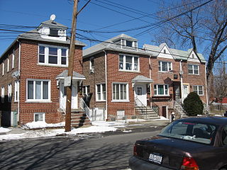
Pelham Bay is a middle class residential neighborhood in the borough of the Bronx, in New York City. It is named for Pelham Bay Park, New York City's largest park, which lies on the neighborhood's northeastern border; and for Pelham Bay, a body of water in that park. The neighborhood is bounded roughly by Pelham Parkway on the north, the New England Thruway (I-95) on the east, the Bruckner Expressway (I-95) on the south, and the Hutchinson River Parkway on the west.
Baychester is a neighborhood geographically located in the northeast part of the Bronx, New York City. Its boundaries are East 222nd Street to the northeast, the New England Thruway (I-95) to the east, Gun Hill Road to the southwest, and Boston Road to the northwest. Eastchester Road is the primary thoroughfare through Baychester.
Pelham Gardens is a neighborhood located in the Northeast section of the Bronx, New York City. Its boundaries, starting from the north and moving clockwise are East Gun Hill Road to the north and east, Pelham Parkway to the south, and the IRT Dyre Avenue Line to the west ending at the esplanade. Eastchester Road is the primary thoroughfare through Pelham Gardens.
Allerton is a working-class neighborhood geographically located in the East Bronx section of the Bronx, New York City. It is named in honor of Daniel Allerton, an early Bronx settler who purchased and farmed this area with his wife Hustace. It consists of two subsections called Bronxwood and Laconia. Its boundaries, starting from the north and moving clockwise, are Adee Avenue, Boston Road, and Gun Hill Road to the northeast; the IRT Dyre Avenue Line to the east; Waring Avenue to the south; and Bronx River Parkway to the west. White Plains Road and Boston Road are the primary thoroughfares through Allerton.

Country Club is a residential neighborhood located in the East Bronx in New York City. The neighborhood's boundaries are Middletown Road and Watt Avenue to the north, Eastchester Bay to the east, Layton Avenue and the Throggs Neck neighborhood to the south, and the New England Thruway and Pelham Bay neighborhood to the west. Pelham Bay Park, the largest public park in New York City, is located just north of Country Club.

Eastchester is a working-class neighborhood in the northeast Bronx in New York City. Its boundaries, starting from the north and moving clockwise are the Bronx-Westchester County border to the north, the New England Thruway to the east, Baychester Avenue to the south, and the intersection of 233rd Street and Baychester Avenue to the west. Boston Road is the primary thoroughfare through Eastchester and Dyre Avenue is the main commercial street. Eastchester includes the sub-neighborhood of Edenwald.

Morris Park is a neighborhood in the New York City borough of the Bronx. Its approximate boundaries, starting from the north and moving clockwise, are Neill Avenue and Pelham Parkway to the north, Eastchester Road to the East, the Amtrak Northeast Corridor tracks and Sackett Avenue to the east and south, and Bronxdale Avenue or White Plains Road to the west. It borders the neighborhoods of Van Nest to its southwest and Pelham Parkway to its northeast. Williamsbridge Road and Morris Park Avenue are the primary thoroughfares.

Pelham Parkway is a working- and middle-class residential neighborhood geographically located in the center of the Bronx, a borough of New York City in the United States. Its boundaries, starting from the north and moving clockwise are: Waring Avenue to the north, the IRT Dyre Avenue Line tracks to the east, Neill Avenue to the South, and Bronx River Parkway to the west. White Plains Road is the primary commercial thoroughfare through Pelham Parkway. The neighborhood is named after Pelham Parkway, a major west–east parkway that travels through the East Bronx.

Castle Hill is a neighborhood located in the southeast section of the borough of the Bronx in New York City. Its boundaries are Waterbury Avenue and Westchester Avenue to the north, Westchester Creek to the east, the East River to the south, and White Plains Road to the west. Unionport is a subsection of Castle Hill, typically considered north of Lafayette Avenue.
Boston Public Schools (BPS) is a school district serving the city of Boston, Massachusetts, United States. It is the largest public school district in the state of Massachusetts.
The White Plains Public School District is a public school district located in White Plains, New York. As of the 2016–2017 school year, the total district enrollment was 7,004 students attending 8 schools in grades Pre-K - 12. As of 2017, the district superintendent is Dr. Joseph Ricca.

Bronxville Union Free School District is a public school district serving the Village of Bronxville, Westchester County, New York. In 2023, 1603 students were enrolled in the district elementary, middle and high school which are all housed within the same large building. In 2012 Bronxville High School was ranked the second best "open enrollment" high school in the US. In 2000 Bronxville High School was ranked the 5th best high school in the country by Newsweek magazine. The high school is also in the top 100 high schools in the country according to US News and is the highest ranked "open enrollment" high school in New York State.
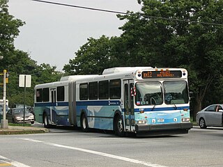
The Bx12 is a public transit line in New York City running along the 207th Street Crosstown Line, within the boroughs of Manhattan and the Bronx. The line runs along 207th Street in Upper Manhattan and along the continuous Fordham Road and Pelham Parkway in the Bronx.
Hauppauge Union Free School District is a public school district, serving Hauppauge, New York. It is near the Commack School District and Half Hollow Hills Central School District.

The Bx23 and Q50 bus routes constitute a public transit corridor in New York City, running from the Flushing neighborhood in Queens to the Pelham Bay and Co-op City neighborhoods in the Bronx. The Bx23 provides local service in Pelham Bay and Co-op City, while the Q50 provides limited-stop service between Co-op City and subway hubs in Pelham Bay and Flushing. Both routes are city-operated under the MTA Bus Company brand of MTA Regional Bus Operations, and are the only two local routes in the Bronx to operate under the MTA Bus brand, rather than under the MaBSOTA brand that all other Bronx bus routes operate under.
The Roslyn Union Free School District is an American public school district located in Nassau County, on Long Island in New York, United States.
Ossining Union Free School District is a school district headquartered in the Village of Ossining, Town of Ossining, New York.

The Port Washington Union Free School District is a public school district on Long Island, in New York.
References
- 1 2 "Pelham UFSD | NYSED Data Site". data.nysed.gov. Retrieved October 9, 2021.
- ↑ "Search for Public School Districts - District Detail for Pelham Union Free School District". nces.ed.gov. Retrieved October 9, 2021.
- ↑ "About Us Archived August 21, 2016, at the Wayback Machine ." Pelham Public Schools. Retrieved on June 28, 2016.
- ↑ Wilson, Colleen (February 15, 2017). "Pelham superintendent resigns". The Journal News . Retrieved January 27, 2020.
- ↑ Wilson, Colleen (September 27, 2017). "Pelham's superintendent goes from orchestra to leader". The Journal News . Retrieved January 27, 2020.
- ↑ "What Happened When a School District Banned Thin Blue Line Flags". The New York Times . November 21, 2020. Retrieved November 21, 2020.
- ↑ Gross, Jane (May 6, 1997). "A Tiny Strip of New York That Feels Like the Suburbs". The New York Times . Archived from the original on July 17, 2016. Retrieved June 28, 2016.()