
Walsh County is a county in the U.S. state of North Dakota. As of the 2020 census, the population was 10,563. Its county seat is Grafton.

Pembina County is a county in the U.S. state of North Dakota. At the 2020 census its population was 6,844. The county seat is Cavalier.
Cavalier County is a county in the U.S. state of North Dakota. It is south of the Canada–US border with Manitoba. As of the 2020 census, the population was 3,704. Its county seat is Langdon. The city of Cavalier is in nearby Pembina County.

Kittson County is a county in the northwestern corner of the U.S. state of Minnesota along the Canada–US border, south of the Canadian province of Manitoba. As of the 2020 census, the population was 4,207. Its county seat is Hallock.

Pembina is a city in Pembina County, North Dakota, United States. The population was 512 at the 2020 census. Pembina is located 2 miles (3.2 km) south of the Canada–US border. Interstate 29 passes on the western side of Pembina, leading north to the Canada–US border at Emerson, Manitoba and south to the cities of Grand Forks and Fargo. The Pembina–Emerson Border Crossing is the busiest between Surrey–Blaine, and Windsor–Detroit, and the fifth busiest along the Canada-United States border. It is one of three 24-hour ports of entry in North Dakota, the others being Portal and Dunseith. The Noyes–Emerson East Border Crossing, located 2 miles (3.2 km) to the east on the Minnesota side of the Red River, also processed cross-border traffic until its closure in 2006.
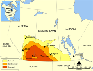
The Missouri Coteau, or Missouri Plateau, is a large plateau that stretches along the eastern side of the valley of the Missouri River in central North Dakota and north-central South Dakota in the United States. In the Canadian provinces of Saskatchewan and Alberta this physiographic region is classified as the Uplands Missouri Coteau, which is a part of the Great Plains Province or Alberta Plateau Region, which extends across the southwest corner of the province of Saskatchewan as well as the southeast corner of the province of Alberta. Historically, in Canada the area was known as the Palliser's Triangle and regarded as an extension of the Great American Desert and unsuitable for agriculture and thus designated by Canadian geographer and explorer John Palliser. The terrain of the Missouri Coteau features low hummocky, undulating, rolling hills, potholes, and grasslands. Apart from being a geographical area, the Missouri Coteau also has a cultural connection to the people of the area, the Métis people of South Dakota, along with other Indigenous groups. The history of this plateau is large, and the Missouri Coteau has a significance to these people.

The Tongue River is a 90.4-mile-long (145.5 km) tributary of the Pembina River in northeastern North Dakota in the United States. It drains an area of the prairie country near the Canada–US border in the extreme northeast corner of the state in the watershed of the Red River.

The Red River Valley is a region in central North America that is drained by the Red River of the North; it is part of both Canada and the United States. Forming the border between Minnesota and North Dakota when these territories were admitted as states in the United States, this fertile valley has been important to the economies of these states and to Manitoba, Canada.
Roseau River Anishinabe First Nation is an Ojibway First Nation in southern Manitoba, Canada, situated around the Roseau River.
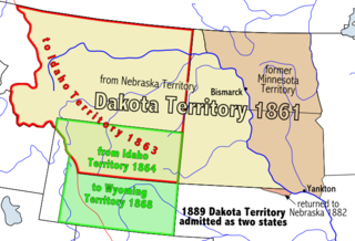
The Pembina Region, also referred to as the Pembina District and Pembina Department, is the historic name of an unorganized territory of land that was ceded to the United States in 1818. The area included the portions of what became the States of Minnesota, North Dakota, and South Dakota lying within the Hudson Bay drainage basin. The area included settlements in the Pembina River area. The region was formerly part of British Rupert's Land, granted by British royal charter to the Hudson's Bay Company. After the Selkirk Concession and establishment of the agricultural Red River Colony in 1812, the area was governed as the District of Assiniboia. The Treaty of 1818 de jure transferred the region south of the 49th parallel to the United States from the British. Settlements south of the boundary continued to be de facto administered as part of Assiniboia until at least 1823.

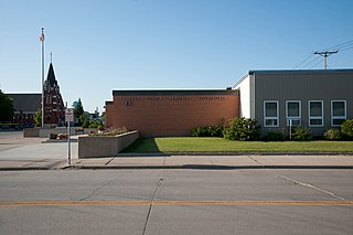
Warsaw is an unincorporated community in Walsh County, North Dakota, United States. It is approximately 5.5 miles east of Minto and about 15 miles southeast of Grafton, the county seat. It is in an area of Walsh County that was settled in the 19th century by immigrants from Poland, and which remained a predominantly Polish-speaking area well beyond the middle of the 20th century. The Catholic Church of St. Stanislaus in Warsaw, built in 1901, is listed in the National Register of Historic Places. Many of the inscriptions on gravestones in the adjacent cemetery are in Polish.

The Geography of North Dakota consists of three major geographic regions: in the east is the Red River Valley, west of this, the Missouri Plateau. The southwestern part of North Dakota is covered by the Great Plains, accentuated by the Badlands. There is also much in the way of geology and hydrology.

Huot is an unincorporated community in Louisville Township, Red Lake County, Minnesota, United States. The name of the community evokes the French-Canadian and Métis history of the Red River Trails and the Pembina settlements of Assiniboia.
Southern Manitoba is the southernmost area of the Canadian province of Manitoba. Southern Manitoba encompasses the Winnipeg Metropolitan Region, Westman Region, Central Plains Region, Eastman Region, and Pembina Valley Region, as well as the Manitoba portion of Red River Valley. Holding a population of over one million, seven of the ten cities in Manitoba are located in this area, including Winnipeg, Brandon, Portage la Prairie, Selkirk, Morden, Winkler, and Steinbach.

The Pembina Escarpment is a scarp that runs from South Dakota to Manitoba, and forms the western wall of the Red River Valley. The height of the escarpment above the river valley is 300–400 feet (91–122 m).
The North Dakota Museum of Art (NDMOA) is the official art museum of the American state of North Dakota. Located on the campus of the University of North Dakota (UND) in Grand Forks, North Dakota, the museum is a private not-for-profit institution. The building includes three exhibition galleries, a video information room, cafe, and gift shop. Admission is free.

The Missouri-Yellowstone Confluence Interpretive Center is a museum near Williston, North Dakota. It is dedicated to telling the story of the confluence of the Yellowstone and the Missouri Rivers in the western section of North Dakota near the Montana border. It features exhibits on the geography, geology, and history of the area. The interpretive center is located one-half mile east of historic Fort Buford near Williston, North Dakota. It also offers dramatic views of the Missouri and Yellowstone Rivers.
The Rural Municipality of Pembina is a former rural municipality (RM) in the Canadian province of Manitoba.
Joliette is an unincorporated community located along Interstate 29 in Joliette Township in Pembina County in the U.S. state of North Dakota. It was established in 1879 as a rural post office. It was settled by French Canadians and named for Joliette, Quebec, the hometown of the town's first settler. the post office is no longer operating and shares the ZIP code 58271 with the city of Pembina.
Gardar is an unincorporated community in Pembina County, in the U.S. state of North Dakota.