
Erie County is a county along the shore of Lake Erie in western New York State. As of the 2020 census, the population was 954,236. The county seat is Buffalo, which makes up about 28% of the county's population. Both the county and Lake Erie were named for the regional Iroquoian language-speaking Erie tribe of Native Americans, who lived in the area before 1654. They were later pushed out by the more powerful Iroquoian nations tribes. The county is part of the Western New York region of the state.
Genesee County is a county in the U.S. state of New York. As of the 2020 census, the population was 58,388. Its county seat is Batavia. Its name is from Seneca word Gen-nis'-hee-yo, meaning "the Beautiful Valley". The county was created in 1802 and organized in 1803. The county is part of the Finger Lakes region of the state.

Clarence is a town and affluent suburb located in the northeastern part of Erie County, New York, United States, northeast of Buffalo. The population was 32,950 according to the 2020 census estimate. This represents an increase of 7.4% from the 2010 census figure. The Clarence census-designated place occupies the southeast part of the town and roughly corresponds to a postal district with ZIP code 14031 and 14221 in the western side which it shares with nearby Williamsville. The town is named in honor of Prince William, Duke of Clarence and St Andrews (1765–1837), the third son of King George III and later king himself, as William IV.

Newstead is the northeasternmost town in Erie County, New York, United States. The population was 8,689 at the 2020 census. The name is reportedly derived from Newstead Abbey in England.

Alabama is a town in Genesee County, New York, United States. The town is in the northwestern part of the county. New York State Routes 63 and 77 intersect in the town. The population was 1,869 at the 2010 census. The town is named after the state of Alabama.

Bethany is a town in Genesee County, New York, United States. The population was 1,765 at the 2010 census. The town lies on the southern border of Genesee County. US Route 20 and NYS Route 63 pass through the town.

Corfu is a village in Genesee County, New York, United States. The population was 709 at the 2010 census. It is named after the Greek island of Corfu.

Darien is a town in Genesee County, New York, United States. The population was 3,010 at the 2020 census. Darien lies in the southwestern part of Genesee County, southwest of Batavia.

Pavilion is a town in Genesee County, New York, United States. The population was 2,495 at the 2010 census. The town was named after a hotel in Saratoga Springs, New York, by an early resident. The town of Pavilion is in the southeastern corner of Genesee County and is southeast of the city of Batavia.

Stafford is a town in Genesee County, New York, United States. The population was 2,459 at the 2010 census. The town was named after a town of the same name in England.
Royalton is a town in Niagara County, New York, United States. The population was 7,660 at the 2010 census.

Alden is a town in Erie County, New York, United States. The population was 10,865 at the 2010 census. The town is derived from a family name known to early settlers.

Alexander is a town in Genesee County, New York, United States. The population was 2,491 at the 2020 census. The town is named after Alexander Rea, an early settler, and is on the southern border of the county. It includes a village also named Alexander.

Batavia is a town in Genesee County, New York, United States. The population was 6,293 at the 2020 census. The name is derived from the Roman name for part of the Netherlands.
Avon is a town in Livingston County, New York, United States. It is south of Rochester. The town population was 7,146 at the 2010 census. The town was named after the River Avon in England. The village of Avon is in the northwest part of the town.

New York State Route 33 (NY 33) is an east–west state highway in western New York in the United States. The route extends for just under 70 miles (113 km) from NY 5 in Buffalo in the west to NY 31 in Rochester in the east. It is, in fact, the only state highway that directly connects both cities, although it is rarely used today for that purpose. The westernmost 10 miles (16 km) of NY 33 in Buffalo and the neighboring town of Cheektowaga have been upgraded into the Kensington Expressway. This section of NY 33 is one of several freeways leading out of downtown and serves as a main route to the Buffalo Niagara International Airport.
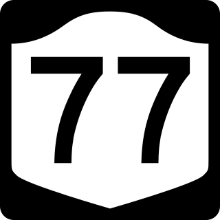
New York State Route 77 (NY 77) is a north–south state highway in the western part of New York in the United States. The highway runs for 46.28 miles (74.48 km) across mostly rural areas from an intersection with NY 78 and NY 98 in the Wyoming County town of Java to a junction with NY 31 near the city of Lockport in Niagara County. It connects to several of the region's major east–west roads, including U.S. Route 20 (US 20) and the New York State Thruway. In southwestern Genesee County, the route takes on added importance as it provides the most direct route between the Thruway and Darien Lake, Western New York's largest amusement park.

New York State Route 98 (NY 98) is a state highway in the western part of New York in the United States. The southern terminus of the route is at an intersection with U.S. Route 219 (US 219) in the town of Great Valley in Cattaraugus County. The northern end is at an interchange with the Lake Ontario State Parkway in the town of Carlton in Orleans County, near the southern shore of Lake Ontario. In between, NY 98 serves the city of Batavia, connects to the New York State Thruway, and passes by the Attica Correctional Facility. Most of the route passes through rural, undeveloped areas; however, in southern Genesee County, it traverses more urbanized areas that lie in and around Batavia.
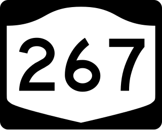
New York State Route 267 (NY 267) was an east–west state highway in the western portion of New York in the United States. It extended for 7.16 miles (11.52 km) from an intersection with NY 93 in the Erie County village of Akron to a junction with NY 77 in the Genesee County hamlet of Basom. Part of NY 267 in Genesee County passed through the Tonawanda Indian Reservation. The portion of NY 267 within Erie County was assigned c. 1935. NY 267 was extended east to NY 77 in Basom in the late 1930s, replacing New York State Route 77A, a spur leading from NY 77 to the eastern edge of the Tonawanda Reservation. The Erie County segment of the route was transferred from the state of New York to Erie County in April 1980, leading to the total removal of the NY 267 designation in August of that year.


