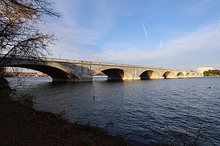
The Arlington Memorial Bridge, often shortened to Memorial Bridge, is a Neoclassical masonry, steel, and stone arch bridge with a central bascule that crosses the Potomac River at Washington, D.C., the capital of the United States. First proposed in 1886, the bridge went unbuilt for decades thanks to political quarrels over whether the bridge should be a memorial, and to whom or what. Traffic problems associated with the dedication of the Tomb of the Unknown Soldier in November 1921 and the desire to build a bridge in time for the bicentennial of the birth of George Washington led to its construction in 1932.

K Street is a major thoroughfare in the United States capital of Washington, D.C., known as a center for lobbying and the location of numerous advocacy groups, law firms, trade associations, and some think tanks. In political discourse, "K Street" has become a metonym for Washington's lobbying industry or lobbying in the United States in general, the same way Wall Street in New York City became a metonym for the financial markets of the United States, since many lobbying firms are or at least traditionally were located on the section in Northwest Washington which passes from Georgetown through a portion of Downtown Washington, D.C.
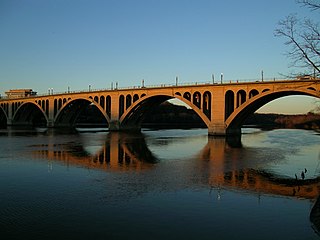
The Francis Scott Key Bridge, more commonly known as the Key Bridge, is a six-lane reinforced concrete arch bridge conveying U.S. Route 29 (US 29) traffic across the Potomac River between the Rosslyn neighborhood of Arlington County, Virginia, and the Georgetown neighborhood of Washington, D.C. Completed in 1923, it is Washington's oldest surviving road bridge across the Potomac River.

The Washington Aqueduct is an aqueduct that provides the public water supply system serving Washington, D.C., and parts of its suburbs, using water from the Potomac River. One of the first major aqueduct projects in the United States, the aqueduct was commissioned by the U.S. Congress in 1852, and construction began in 1853 under the supervision of Montgomery C. Meigs and the U.S. Army Corps of Engineers. Portions of the aqueduct went online on January 3, 1859, and the full pipeline began operating in 1864.

The Dumbarton Bridge, also known as the Q Street Bridge and the Buffalo Bridge, is a historic masonry arch bridge in Washington, D.C.

The Duke Ellington Bridge, named after American jazz pianist Duke Ellington, carries Calvert Street NW over Rock Creek in Washington, D.C., United States. It connects 18th Street NW in Adams Morgan with Connecticut Avenue NW in Woodley Park, just north of the Taft Bridge.
The Georgetown Reservoir is a reservoir that provides water to the District of Columbia. Part of the city’s water supply and treatment infrastructure, it is located in the Palisades neighborhood, approximately two miles downstream from the Maryland–D.C. boundary.

The Aqueduct Bridge was a bridge that carried traffic between Georgetown, Washington, D.C., and Rosslyn, Virginia, from 1843 to 1923.

The M Street Bridge, also known as the M Street Overpass, carries M Street across Rock Creek and the Rock Creek and Potomac Parkway. It lies between the neighborhoods of Georgetown and Foggy Bottom in Northwest Washington, D.C. The non-arched design of the bridge contrasts with that of all the other bridges rising over the parkway.

The Hares Hill Road Bridge is a single-span, wrought iron, bowstring-shaped lattice girder bridge. It was built in 1869 by Moseley Iron Bridge and Roof Company and is the only known surviving example of this kind. The bridge spans French Creek, a Pennsylvania Scenic River.
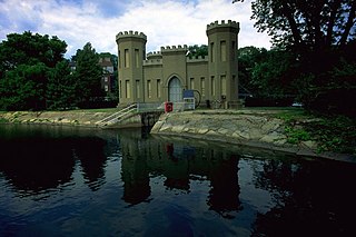
The Union Arch Bridge, also called the "Cabin John Bridge", is a historic masonry structure in Cabin John, Maryland. It was designed as part of the Washington Aqueduct. The bridge construction began in 1857 and was completed in 1864. The roadway surface was added later. The bridge was designed by Alfred Landon Rives, and built by the United States Army Corps of Engineers under the direction of Lieutenant Montgomery C. Meigs.

The Sudbury Aqueduct is an aqueduct in Massachusetts. It runs for 16 miles (26 km) from Farm Pond at Waverly Street in Framingham to Chestnut Hill Reservoir in Boston’s Chestnut Hill neighborhood. A later built extension main runs from the Farm Pond gatehouse to the gatehouse at the Stearns Reservoir where additional mains connect to the Brackett and Foss Reservoirs Going east from Framingham, it runs through Sherborn before entering Natick. From Natick it runs east through Wellesley and Needham to the Charles River, which it crosses on the Echo Bridge into Newton. It ends at the Chestnut Hill Reservoir on the Newton side of the Newton-Boston line. The Massachusetts Water Resources Authority (MWRA) operates the aqueduct.

The Wilmington Rail Viaduct is a series of fills and bridges, about 4 miles (6.4 km) long, that carries the Northeast Corridor through the city of Wilmington, Delaware, above street level. Constructed between 1902 and 1908, the structure consists principally of fills supported by heavy stone retaining walls, punctuated with plate girder bridges over streets, and augmented by a few sections of brick arch viaduct. Its construction is typical of the Pennsylvania Railroad's architectural practices at the time, and the viaduct has been documented by the Historic American Engineering Record and listed on the National Register of Historic Places. Built by the Pennsylvania Railroad (PRR) as part of a series of grade crossing eliminations along the Northeast Corridor, the elevation of the rail line necessitated several other changes to rail infrastructure in Wilmington, including the construction of the Wilmington Shops at the east end of the viaduct, and the construction of the Wilmington Station and adjacent Pennsylvania Railroad Office Building along the elevated right-of-way.
Piney Branch is a tributary of Rock Creek in Washington, D.C. It is the largest tributary located entirely within the Washington city limits.

The construction of Arlington Memorial Bridge was a seven-year construction project in Washington, D.C., in the United States to construct the Arlington Memorial Bridge across the Potomac River. The bridge was authorized by Congress in February 1925, and was completed in January 1932. As a memorial, its decorative features were extensive and intricate, and resolving the design issues over these details took many years. Tall columns and pylons topped by statuary, Greek Revival temple-like structures, and statue groups were proposed for the ends of the bridge. Carvings and inscriptions were planned for the sides of the bridge, and extensive statuary for the bridge piers.

The Shoreham Hill Bridge is a bridge carrying the Rock Creek and Potomac Parkway across Rock Creek in Washington, DC. It is the most upstream of three bridges where the Rock Creek and Potomac Parkway switches from one side of the river to the other, the others being the bridge near P Street and the L Street Bridge.

The Cooks River Sewage Aqueduct is a heritage-listed sewage aqueduct located at Pine Street, Earlwood, New South Wales, Australia. It crosses the Cooks River to Thornley Street, Marrickville. It was designed by Sewerage Construction Branch and NSW Department of Public Works and built during 1895 by J. F. Carson, contractor. The property is owned by Sydney Water, an agency of the Government of New South Wales. It was added to the New South Wales State Heritage Register on 18 November 1999.

The Wolli Creek Aqueduct is a heritage-listed sewage aqueduct located at Unwin Street, Earlwood, City of Canterbury-Bankstown, New South Wales, Australia.

The Mosman Bay Sewage Aqueduct is a heritage-listed public pedestrian bridge and sewage aqueduct at Avenue Road, Mosman in the Mosman Council local government area of New South Wales, Australia. It was designed by Sewerage Construction Branch and NSW Department of Public Works and built from 1899 to 1901 by NSW Department of Public Works. It is also known as the Aqueduct over Mosman Bay. The property is owned by Sydney Water, an agency of the Government of New South Wales. It was added to the New South Wales State Heritage Register on 18 November 1999.

The Rock Creek Trails are a series of trails through the Rock Creek valley and along the Potomac River in Washington, DC and Montgomery County, MD. The main route extends 22 miles from Lake Needwood in Maryland to the Inlet Bridge in Washington, DC, with a loop in the north part of Rock Creek Park and other trails through the Klingle Valley, Turkey Branch Valley and along the North Branch of Rock Creek. There are three separate trails that make up the main Rock Creek Trail route and others that connect to it. Along the Potomac River from Arlington Memorial Bridge to Rock Creek is a section sometimes called the Shoreline Trail.


