
Monroe County is a county in the state of Florida. As of the 2020 census, the population was 82,874. Its county seat is Key West. Monroe County includes the islands of the Florida Keys and comprises the Key West-Key Largo Micropolitan Statistical Area. Over 99.9% of the county's population lives on the Florida Keys. The mainland, which is part of the Everglades, comprises 87% of the county's land area and is virtually uninhabited with only 17 people recorded in the 2020 census.

Moore Haven is a city in, and the county seat of, Glades County, Florida, United States. It is part of the Florida Heartland region. The population was 1,566 at the 2020 census, down from 1,680 at the 2010 census. Moore Haven is located on the southwest shoreline of Lake Okeechobee. It is part of the Clewiston, Florida Micropolitan Statistical Area (μSA).

Cudjoe Key is a census-designated place and unincorporated community in Monroe County, Florida, United States, on an island of the same name in the lower Florida Keys. As of the 2020 census, the CDP had a population of 2,019, up from 1,763 in 2010.

Key Colony Beach is a municipality in the middle of the Florida Keys, Monroe County, Florida, United States. The population was 790 at the 2020 census.

Key West is an island in the Straits of Florida, within the U.S. state of Florida. Together with all or parts of the separate islands of Dredgers Key, Fleming Key, Sunset Key, and the northern part of Stock Island, it constitutes the City of Key West.

The Florida Keys are a coral cay archipelago off the southern coast of Florida, forming the southernmost part of the continental United States. They begin at the southeastern coast of the Florida peninsula, about 15 miles (24 km) south of Miami and extend in a gentle arc south-southwest and then westward to Key West, the westernmost of the inhabited islands, and on to the uninhabited Dry Tortugas. The islands lie along the Florida Straits, dividing the Atlantic Ocean to the east from the Gulf of Mexico to the northwest, and defining one edge of Florida Bay. The southern part of Key West is 93 miles (150 km) from Cuba. The Keys are located between about 24.3 and 25.5 degrees North latitude.

Scout Key is an island in the lower Florida Keys. It was previously known as West Summerland Key until 2010. U.S. 1 crosses the key at approximately mile markers 34–35, between Spanish Harbor Key and Big Pine Key.

Big Coppitt Key is an island in Monroe County, Florida, United States, in the lower Florida Keys. The name is said to be a derivation of the old English word "coppice", meaning thicket. According to A.D. Bache, in the notes for his coast survey conducted in 1861, this key was the location of Happy Jack's plantation in 1855.

The Overseas Highway is a 113-mile (181.9 km) highway carrying U.S. Route 1 (US 1) through the Florida Keys to Key West. Large parts of it were built on the former right-of-way of the Overseas Railroad, the Key West Extension of the Florida East Coast Railway. Completed in 1912, the Overseas Railroad was heavily damaged and partially destroyed in the 1935 Labor Day hurricane. The Florida East Coast Railway was financially unable to rebuild the destroyed sections, so the roadbed and remaining bridges were sold to the state of Florida for $640,000.

The Marquesas Keys form an uninhabited island group about 20 miles (32 km) west of Key West, four miles (6 km) in diameter, and largely covered by mangrove forest. They are an unincorporated area of Monroe County, Florida and belong to the Lower Keys Census County Division. They are protected as part of the Key West National Wildlife Refuge. The Marquesas were used for target practice by the military as recently as 1980.

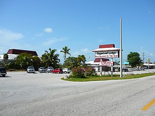
Sugarloaf Key is a single island in the lower Florida Keys that forms a loop on the Atlantic Ocean side, giving the illusion of separate islands. Although frequently referred to simply and with technical accuracy as "Sugarloaf Key", this island contains two distinct island communities, known as Lower Sugarloaf Key and Upper Sugarloaf Key.
Lower Sugarloaf Key is the lower arm of an island known as Sugarloaf Key in the lower Florida Keys about 13 miles (21 km) east of Key West.

The Ernest Hemingway House was the residence of American writer Ernest Hemingway in the 1930s. The house is situated on the island of Key West, Florida. It is at 907 Whitehead Street, across from the Key West Lighthouse, close to the southern coast of the island. Due to its association with Hemingway, the property is the most popular tourist attraction in Key West. It is also famous for its large population of so-called Hemingway cats, many of which are polydactyl.

The Sugarloaf Key Bat Tower, also known as the Perky Bat Tower, is a historic site in Monroe County, Florida, United States. It is located a mile northwest of U.S. Route 1 on Lower Sugarloaf Key at mile marker 17. On May 13, 1982, it was added to the National Register of Historic Places. The tower was blown down during Hurricane Irma in 2017.
Sugarloaf Shores is an unincorporated community in Monroe County, Florida, United States, located in the lower Florida Keys on Lower Sugarloaf Key near mile marker 17 on US 1.
A hurricane local statement (HLS) is a weather statement produced for the public by the local Weather Forecast Offices of the National Weather Service in the U.S. for areas affected or forecast to be affected by a tropical storm or hurricane that provides an overview of the storm's local effects, including expected weather conditions, evacuation decisions made by local officials, and precautions necessary to protect life and property. The National Weather Services considers the HLS to be the "flagship product" available to Weather Forecast Offices for outlining tropical cyclone watches and warnings and impacts, and is their most visible product during such events. Descriptions of the affected areas, relevant tropical cyclone watches and warnings, recommendations for precautionary measures, and expected timing and severity of possible threats are typically included in an HLS. The HLS can incorporate projected impacts from pre-written descriptions tailored for different storm intensities; these template descriptions were developed in the 1990s and became widely available to forecasters for use in the HLS by 2001. The bulletin issued by the Weather Forecast Office in Slidell, Louisiana, as Hurricane Katrina approached on August 28, 2005, known as "The Bulletin", was lauded by the National Weather Service as having further encouraged vulnerable individuals to evacuate. Not all forecast offices can issue an HLS.

The 2017 Atlantic hurricane season was an event in the annual tropical cyclone season in the north Atlantic Ocean. This Atlantic hurricane season saw above-normal activity; it was the seventh most active season on record and the most active since 2005. The season officially began on June 1, 2017 and ended on November 30, 2017. These dates, adopted by convention, historically describe the period in each year when most tropical systems form. However, storm formation is possible at any time of the year, as demonstrated in 2017 by the formation of the season's first named storm, Tropical Storm Arlene, on April 19. The final storm of the season, Tropical Storm Rina degenerated to a remnant area of low pressure on November 9.
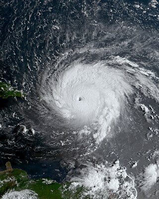
Hurricane Irma was an extremely powerful Cape Verde hurricane that caused widespread destruction across its path in early September 2017. Irma was the first Category 5 hurricane to strike the Leeward Islands on record, followed by Maria two weeks later. At the time, it was considered the most powerful hurricane on record in the open Atlantic region, outside of the Caribbean Sea and Gulf of Mexico, until it was surpassed by Hurricane Dorian two years later. It was also the third-strongest Atlantic hurricane at landfall ever recorded, just behind the 1935 Labor Day Hurricane and Dorian. The ninth named storm, fourth hurricane, second major hurricane, and first Category 5 hurricane of the extremely active 2017 Atlantic hurricane season, Irma caused widespread and catastrophic damage throughout its long lifetime, particularly in the northeastern Caribbean and the Florida Keys. It was also the most intense hurricane to strike the continental United States since Katrina in 2005, the first major hurricane to make landfall in Florida since Wilma in the same year, and the first Category 4 hurricane to strike the state since Charley in 2004. The word Irmageddon was coined soon after the hurricane to describe the damage caused by the hurricane.

Hurricane Irma was the costliest tropical cyclone in the history of the U.S. state of Florida, before being surpassed by Hurricane Ian in 2022. Irma developed from a tropical wave near the Cape Verde Islands on August 30, 2017. The storm quickly became a hurricane on August 31 and then a major hurricane shortly thereafter, but would oscillate in intensity over the next few days. By September 4, Irma resumed strengthening, and became a powerful Category 5 hurricane on the following day. The cyclone then struck Saint Maarten and the British Virgin Islands on September 6 and later crossed Little Inagua in the Bahamas on September 8. Irma briefly weakened to a Category 4 hurricane, but re-intensified into a Category 5 hurricane before making landfall in the Sabana-Camagüey Archipelago of Cuba. After falling to Category 3 status due to land interaction, the storm re-strengthened into a Category 4 hurricane in the Straits of Florida. Irma struck Florida twice on September 10 – the first as a Category 4 at Cudjoe Key and the second on Marco Island as a Category 3. The hurricane weakened significantly over Florida, and was reduced to a tropical storm, before exiting the state into Georgia on September 11.
Poe Springs is a spring about 3 miles west of High Springs, Florida. It is located in Poe Springs Park, which is 202 acres in size. The spring is isolated from the main part of the park at its center, requiring a 0.3 mile hike one-way. The water temperature is 72 degrees Fahrenheit. It is managed by Alachua County Parks and Recreation and is $5.00 per car to visit. Poe Springs Park is the only county-run park that allows swimming. In addition to swimming, snorkeling is also popular. However, scuba diving is not allowed. The spring produces an average volume of 45 million gallons of water daily that feed into the Santa Fe River. The spring vent is 25 feet deep.


