Related Research Articles

Umbriel is a moon of Uranus discovered on October 24, 1851, by William Lassell. It was discovered at the same time as Ariel and named after a character in Alexander Pope's 1712 poem The Rape of the Lock. Umbriel consists mainly of ice with a substantial fraction of rock, and may be differentiated into a rocky core and an icy mantle. The surface is the darkest among Uranian moons, and appears to have been shaped primarily by impacts. However, the presence of canyons suggests early endogenic processes, and the moon may have undergone an early endogenically driven resurfacing event that obliterated its older surface.

Callisto, or Jupiter IV, is the second-largest moon of Jupiter, after Ganymede. In the Solar System it is the third-largest moon after Ganymede and Saturn's largest moon Titan, and as large as the smallest planet Mercury, though only about a third as massive. Callisto is, with a diameter of 4821 km, roughly a third larger than the Moon and orbits Jupiter on average at a distance of 1883000 km, which is about six times further out than the Moon orbiting Earth. It is the outermost of the four large Galilean moons of Jupiter, which were discovered in 1610 with one of the first telescopes, being visible from Earth with common binoculars.

Proteus, also known as Neptune VIII, is the second-largest Neptunian moon, and Neptune's largest inner satellite. Discovered by Voyager 2 spacecraft in 1989, it is named after Proteus, the shape-changing sea god of Greek mythology. Proteus orbits Neptune in a nearly equatorial orbit at a distance of about 4.75 times the radius of Neptune's equator.

Ariel is the fourth-largest of the 27 known moons of Uranus. Ariel orbits and rotates in the equatorial plane of Uranus, which is almost perpendicular to the orbit of Uranus and so has an extreme seasonal cycle.

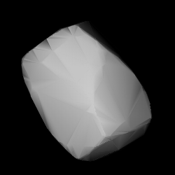
1036 Ganymed, provisional designation 1924 TD, is a stony asteroid on a highly eccentric orbit, classified as a near-Earth object of the Amor group. It was discovered by German astronomer Walter Baade at the Bergedorf Observatory in Hamburg on 23 October 1924, and named after Ganymede from Greek mythology. With a diameter of approximately 35 kilometers, Ganymed is the largest of all near-Earth objects but does not cross Earth's orbit. The S-type asteroid has a rotation period of 10.3 hours. In October 2024, it is predicted to approach Earth at a distance of 56,000,000 km; 35,000,000 mi (0.374097 AU).
Ausonia is a stony Vestian asteroid from the inner region of the asteroid belt, approximately 100 kilometers in diameter. It was discovered by Italian astronomer Annibale de Gasparis on 10 February 1861, from the Astronomical Observatory of Capodimonte, in Naples, Italy. The initial choice of name for the asteroid was "Italia", after Italy, but this was modified to Ausonia, an ancient classical name for the Italian region.

Io (minor planet designation: 85 Io is carbonaceous asteroid from the central region of the asteroid belt, approximately 170 kilometers in diameter. It is an identified Eunomian interloper.
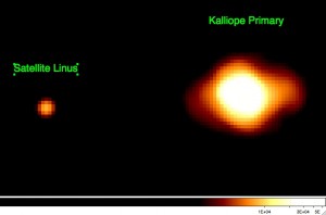
Kalliope is a large M-type asteroid from the asteroid belt discovered by J. R. Hind on 16 November 1852. It is named after Calliope, the Greek Muse of epic poetry. It is orbited by a small moon named Linus.
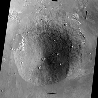
Hecates Tholus is a Martian volcano, notable for results from the European Space Agency's Mars Express mission which indicate a major eruption took place 350 million years ago. The eruption created a caldera 10 km in diameter on the volcano's western flank.
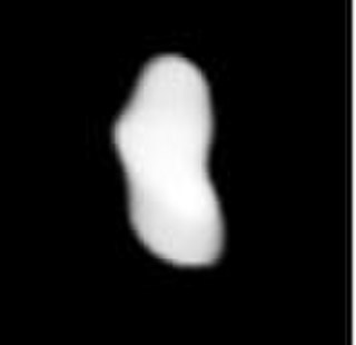
462 Eriphyla is a Koronian asteroid from the outer regions of the asteroid belt. It was discovered by German astronomer Max Wolf at the Heidelberg-Königstuhl State Observatory on 22 October 1900. The stony S-type asteroid has a rotation period of 8.7 hours and measures approximately 35 kilometers in diameter. It was named after Eriphyle, from Greek mythology.

Elysium, located in the Elysium and Cebrenia quadrangles, is the second largest volcanic region on Mars, after Tharsis. The region includes the volcanoes Hecates Tholus, Elysium Mons and Albor Tholus. The province is centered roughly on Elysium Mons at 24.7°N 150°E. Elysium Planitia is a broad plain to the south of Elysium, centered at 3.0°N 154.7°E. Another large volcano, Apollinaris Mons, lies south of Elysium Planitia and is not part of the province. Besides having large volcanoes, Elysium has several areas with long trenches, called fossa or fossae (plural) on Mars. They include the Cerberus Fossae, Elysium Fossae, Galaxias Fossae, Hephaestus Fossae, Hyblaeus Fossae, Stygis Fossae and Zephyrus Fossae.
In astronomy, the geometric albedo of a celestial body is the ratio of its actual brightness as seen from the light source to that of an idealized flat, fully reflecting, diffusively scattering (Lambertian) disk with the same cross-section.
Radioglaciology is the study of glaciers, ice sheets, ice caps and icy moons using ice penetrating radar. It employs a geophysical method similar to ground-penetrating radar and typically operates at frequencies in the MF, HF, VHF and UHF portions of the radio spectrum. This technique is also commonly referred to as "Ice Penetrating Radar (IPR)" or "Radio Echo Sounding (RES)".
Thermophysics is the application of thermodynamics to geophysics and to planetary science more broadly. It may also be used to refer to the field of thermodynamic and transport properties.

1580 Betulia, provisional designation 1950 KA, is an eccentric, carbonaceous asteroid, classified as near-Earth object of the Amor group, approximately 4.2 kilometers in diameter. It was discovered on 22 May 1950, by South African astronomer Ernest Johnson at the Union Observatory in Johannesburg. The asteroid was named for Betulia Toro, wife of astronomer Samuel Herrick.
The Minnaert function is a photometric function used to interpret astronomical observations and remote sensing data for the Earth. It was named after the astronomer Marcel Minnaert. This function expresses the radiance factor (RADF) as a function the phase angle, the photometric latitude and the photometric longitude.
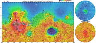
The most conspicuous feature of Mars is a sharp contrast, known as the Martian dichotomy, between the Southern and the Northern hemispheres. The two hemispheres' geography differ in elevation by 1 to 3 km. The average thickness of the Martian crust is 45 km, with 32 km in the northern lowlands region, and 58 km in the southern highlands.

Lobate debris aprons (LDAs) are geological features on Mars, first seen by the Viking Orbiters, consisting of piles of rock debris below cliffs. These features have a convex topography and a gentle slope from cliffs or escarpments, which suggest flow away from the steep source cliff. In addition, lobate debris aprons can show surface lineations as do rock glaciers on the Earth.

Occator is an impact crater located on Ceres, the largest object in the main asteroid belt that lies between the orbits of Mars and Jupiter, that contains "Spot 5", the brightest of the bright spots observed by the Dawn spacecraft. It was known as "Region A" in ground-based images taken by the W. M. Keck Observatory on Mauna Kea.
References
- ↑ Wildey, R (1975). "Generalized photoclinometry for Mariner 9". Icarus. 25 (4): 613–626. Bibcode:1975Icar...25..613W. doi:10.1016/0019-1035(75)90043-3.
- ↑ Hargitai, Henrik; Willner, Konrad; Buchroithner, Manfred (2019), Hargitai, Henrik (ed.), "Methods in Planetary Topographic Mapping: A Review", Planetary Cartography and GIS, Lecture Notes in Geoinformation and Cartography, Springer International Publishing, pp. 147–174, doi:10.1007/978-3-319-62849-3_6, ISBN 978-3-319-62849-3
- ↑ van Diggelen, J (July 1951). "A photometric investigation of the slopes and the heights of the ranges of hills in the maria of the moon". Bull. Astron. Inst. Netherlands. 11: 283. Bibcode:1951BAN....11..283V.
- ↑ Howard, Alan D.; Blasius, Karl R.; Cutts, James A. (1982). "Photoclinometric determination of the topography of the Martian north polar cap". Icarus. 50 (2–3): 245–258. Bibcode:1982Icar...50..245H. doi:10.1016/0019-1035(82)90125-7.
- ↑ Bidschadler, R. A.; Vornberger, P. L. (1994). "Detailed elevation map of Ice Stream C, Antarctica, using satellite imagery and airborne radar". Annals of Glaciology. 20: 327–335. Bibcode:1994AnGla..20..327B. doi: 10.3189/1994aog20-1-327-335 . ISSN 0260-3055.
- ↑ Scambos, Ted A.; Haran, Terry (2002). "An image-enhanced DEM of the Greenland ice sheet". Annals of Glaciology. 34: 291–298. Bibcode:2002AnGla..34..291S. doi: 10.3189/172756402781817969 . ISSN 0260-3055.
- ↑ Greene, C. A.; Blankenship, D. D. (2017). "A Method of Repeat Photoclinometry for Detecting Kilometer-Scale Ice Sheet Surface Evolution". IEEE Transactions on Geoscience and Remote Sensing. PP (99): 2074–2082. doi:10.1109/tgrs.2017.2773364. ISSN 0196-2892.
- ↑ Glaze, Lori S.; Wilson, Lionel; Mouginis-Mark, Peter J. (1999-02-10). "Volcanic eruption plume top topography and heights as determined from photoclinometric analysis of satellite data". Journal of Geophysical Research: Solid Earth. 104 (B2): 2989–3001. Bibcode:1999JGR...104.2989G. doi: 10.1029/1998jb900047 . ISSN 2156-2202.