Pikeview, Colorado

Last updated
Home of William Morrison, miner, who lives in company housing project. Pikes Peak Fuel Company, Pike View Mine, Colorado Springs, 1946 Home of William Morrison, miner, who lives in company housing project. Pikes Peak Fuel Company, Pike View Mine... - NARA - 540444.tif
Home of William Morrison, miner, who lives in company housing project. Pikes Peak Fuel Company, Pike View Mine, Colorado Springs, 1946

Pikeview (Pike View, Pike's View) is a neighborhood of Colorado Springs, annexed to the city as the "Pike View Addition" on August 1, 1962. [1] [2] In 1896 there was a Denver and Rio Grande Western Railroad station in Pikeview, and miners had begun digging a shaft for the Pikeview Coal Mine. Pikeview also had a quarry beginning 1905 for the mining of limestone for concrete. Coal mining ended in 1957, but the Pikeview Quarry continues to operate. Quarry operations, though, have created a gash or scar in the landscape and efforts have been made since the late 1980s to reclaim the hillside landscape. The Greg Francis Bighorn Sheep Habitat in what had been Queens Canyon Quarry was founded in 2003 in recognition of the individuals and organizations that have worked to create a nature hillside habitat.

Contents

Railroad station

The town of Pikeview, which began as a Denver and Rio Grande Western Railroad station [3] [4] by 1896. [5] :16 It was named for the scenic view of Pikes Peak 10 miles (16 km) away. [6] The Denver and Rio Grande Railroad station was situated at a confluence on Monument Creek, north of the Roswell junction and south from the 1875 Husted station.

Colorado Springs water system

Two Pike View Reservoirs, which were part of the extension of Colorado Springs Irrigation System to Monument Creek, were constructed in 1894. [7] :105,107,240

Town

A school house was built in Pikeview 1 mi (1.6 km) north of the station by 1903. The Pikes View Coal Mine was the same distance from the station. The post office was 4 mi (6.4 km) south of the station. [8] By 1906, the station included a depot, a pond, and a road intersection of the north-south Monument Valley Highway (now Interstate 25) with a road west [9] to Rampart Range.

Pikeview Coal Mine

External images
Searchtool.svg Inactive Coal Mine Data and Subsidence Information for El Paso County (map)
Searchtool.svg Rockrimmon / Pikeview (map)
Searchtool.svg Pikeview Coal Mine
Searchtool.svg Pikeview Mine buildings

A shaft was sunk in late 1896 and the main coal was discovered at what would be the Pikeview Mine, also called the Carlton Mine, on January 1, 1897. The Pikeview Mine is a slope mine, which uses the room-and-pillar method to extract coal. [10] [11] [lower-alpha 1]

In the early 1900s, there was a mass exodus of people from Southern Europe. Many immigrants to the United States headed for the mining towns of Colorado—like Pikeview, Papeton, and Franceville—directly after having entered the country. [5] :7 Many of the mine workers were Greek, and when the men went on strike in 1913 a man named Louis Tikas who worked for the United Mine Workers went to the mine to work undercover and take affidavits of workers regarding working conditions. The workers may have been prompted to return to work and await a coordinated union walkout because most of the Pikeview miners returned to work after a few days at the same pay rate. [13] :70–72

In a letter dated August 28, 1913, Tikas summarized that there were 350 Greek men working in the Southern Fields, which included Pikeview, Las Animas County and Huerfano County mines. There had been 13 men killed on the job and many more that had been injured since January 1, 1913. Affidavits taken by a Greek-speaking individual was important, otherwise information about the immigrants was often overlooked by government and company reports. They also paid very high prices for goods from the company stores, had seen the scales that weighed coal significantly under-report the mined coal per coal car, did not receive good medical treatment, and were dissuaded from seeing attorneys while in the hospital. [13] :72–73

Tikas reported of the Greek mine workers of Southern Colorado,

They are ready at any time unless conditions improve to engage in an industrial war and to fight, just as their fathers and brothers in the fatherland had fought the Turks until their freedom had been obtained, so these men are ready even at the sacrifice of their lives to fight until their industrial freedom had been obtained.

Louis Tikas, United Mine Workers [13] :73

Labor conflicts like this immediately precipitated the Colorado Coalfield War, a strike that began in September 1913 and ran for more than year, with a significant escalation of violence in late April 1914 following the Ludlow Massacre, during which Tikas and other Greek strikers were killed by Colorado National Guardsmen and local militia.

The Pikes Peak Consolidated Fuel Company, a subsidiary of Golden Cycle Mining and Reduction Company, was located in Pikeview in 1920. Harvey McGarry of Colorado Springs was the president and Robert O'Neil of Pikeview was the superintendent. [14] In 1922, Pikeview's economy was nearly entirely based upon mining. [6]

The mine was owned by Golden Cycle Mining when it closed operations July 1, 1957. At that time, there were 30 miners who lived in company housing on the site who were affected. Management personnel were transferred to other Golden Cycle operations. [12]

Pikeview Quarry

Quarry scar

Pikeview Quarry has operated since 1905 and Queens Canyon Quarry has been mined for limestone since 1958. The extraction of the stone by Castle Concrete created a noticeable gash or scar in the Queens Canyon Quarry, north of Garden of the Gods, which closed in 1990. [15]

Reclamation

There is some mining that occurs at Pikeview Quarry, but that effort is being moved to another side of the hill. As the shift occurs, the terrain will cut back the quarry into the mountain, a plan devised by Greg Francis who worked for Castle Concrete for 30 years and spent 15 of those years working on reclamation of the quarried landscape. He started with Pikeview Quarry, about one mile north of Queen's Quarry. After failed reclamation attempts, he devised the plan to cut back the hill so that it can be "resculpted" into a terrain that will better support planted trees and landscaping. "Time and moisture will blend the quarry into the surrounding hillsides," states Colorado Mountain Reclamation Foundation (formed 1992) project manager, Wanda Reaves. By fall of 2003, 2,000 trees had been planted. An additional 800 trees were to be planted on the Pikeview Quarry in 2004. Castle Concrete intended to mine Pikeview Quarry until 2013, so the reclamation efforts were intended to continue throughout that timeframe. [15]

Greg Francis Bighorn Sheep Habitat

On August 1, 2003, the hillside was renamed Greg Francis Bighorn Sheep Habitat in honor of Francis, who died October 2002. A statue of a bighorn sheep stands on Greg Francis Bighorn Sheep Habitat in recognition of the herd of 65 bighorns (in 2003) and Greg Francis, hundreds of volunteers, and efforts by Castle Concrete to reintroduce Rocky Mountain juniper trees, native grasses, and small piñon to the hills. [15]

See also

Preceding station Denver and Rio Grande Western Railroad Following station
Roswell
toward Ogden
Royal Gorge Route Palmer Lake
toward Denver

Notes

  1. The Gazette said in 2015 that the Pikeview Coal Mine operated beginning in 1904. [12]

Related Research Articles

<span class="mw-page-title-main">Denver and Rio Grande Western Railroad</span> American railroad company

The Denver and Rio Grande Western Railroad, often shortened to Rio Grande, D&RG or D&RGW, formerly the Denver & Rio Grande Railroad, was an American Class I railroad company. The railroad started as a 3 ft narrow-gauge line running south from Denver, Colorado, in 1870. It served mainly as a transcontinental bridge line between Denver and Salt Lake City, Utah. The Rio Grande was also a major origin of coal and mineral traffic.

<span class="mw-page-title-main">Lake City, Colorado</span> Town in Colorado, United States

Lake City is a statutory town that is the county seat, the most populous community, and the only incorporated municipality in Hinsdale County, Colorado, United States. The population was 432 at the 2020 census. It is located in the San Juan Mountains in a valley formed by the convergence of Henson Creek and the headwaters of the Lake Fork of the Gunnison River about seven miles (11 km) east of Uncompahgre Peak, a Colorado fourteener. Lake City is named after nearby Lake San Cristobal. This area lies at the southern end of the Colorado Mineral Belt and when rich mineral deposits were discovered the native population was pushed from their tribal lands and the town of Lake City was incorporated in 1873.

<span class="mw-page-title-main">Ludlow Massacre</span> April 1914 massacre during the Colorado Coalfield War

The Ludlow Massacre was a mass killing perpetrated by anti-striker militia during the Colorado Coalfield War. Soldiers from the Colorado National Guard and private guards employed by Colorado Fuel and Iron Company (CF&I) attacked a tent colony of roughly 1,200 striking coal miners and their families in Ludlow, Colorado, on April 20, 1914. Approximately 21 people, including miners' wives and children, were killed. John D. Rockefeller Jr., a part-owner of CF&I who had recently appeared before a United States congressional hearing on the strikes, was widely blamed for having orchestrated the massacre.

<span class="mw-page-title-main">History of Colorado</span> History of the U.S. State of Colorado

The region that is today the U.S. State of Colorado has been inhabited by Native Americans and their Paleoamerican ancestors for at least 13,500 years and possibly more than 37,000 years. The eastern edge of the Rocky Mountains was a major migration route that was important to the spread of early peoples throughout the Americas. The Lindenmeier site in Larimer County contains artifacts dating from approximately 8720 BCE.

<span class="mw-page-title-main">Ludlow, Colorado</span> Unincorporated town in Las Animas County, Colorado

Ludlow is a ghost town in Las Animas County, Colorado, United States. It was the site of the Ludlow Massacre–part of the Colorado Coalfield War–in 1914. The town site is located at the entrance to a canyon in the foothills of the Sangre de Cristo Mountains. It is located along the western side of Interstate 25 approximately 12 miles (19 km) north of the town of Trinidad. Nearby points of interest include the Ludlow Monument, a monument to the coal miners and their families who were killed in the 1914 massacre, the Hastings coke ovens, and the Victor American Hastings Mine Disaster Monument.

<span class="mw-page-title-main">David Moffat</span> American industrialist (1839–1911)

David Halliday Moffat was an American financier and industrialist.

<span class="mw-page-title-main">Castle Gate, Utah</span> Ghost town in Utah, United States

Castle Gate is a ghost town in the western United States, located in Carbon County in eastern Utah. A mining town approximately ninety miles (140 km) southeast of Salt Lake City, its name was derived from a rock formation near the mouth of Price Canyon. This formation features two sheer sandstone walls on either side of the Price River, which appear to open like a giant gate as travelers approach this narrow section of the canyon.

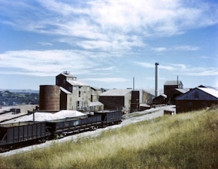
Early coal mining in Colorado in the United States was spread across the state. Some early coal mining areas are currently inactive, including the Denver Basin and Raton Basin coal fields along the Front Range. There are currently 11 active coal mines, all in western Colorado.

<span class="mw-page-title-main">History of Colorado Springs, Colorado</span> Place in Colorado, United States

Before it was founded, the site of modern-day Colorado Springs, Colorado, was part of the American frontier. Old Colorado City, built in 1859 during the Pike's Peak Gold Rush was the Colorado Territory capital. The town of Colorado Springs was founded by General William Jackson Palmer as a resort town. Old Colorado City was annexed into Colorado Springs. Railroads brought tourists and visitors to the area from other parts of the United States and abroad. The city was noted for junctions for seven railways: Denver and Rio Grande (1870), Denver and New Orleans Manitou Branch (1882), Colorado Midland (1886-1918), Colorado Springs and Interurban, Atchison, Topeka, and Santa Fe (1889), Rock Island (1889), and Colorado Springs and Cripple Creek Railways. It was also known for mining exchanges and brokers for the Cripple Creek Gold Rush.

Austin Bluffs is a summit in the Pikeview area of Colorado Springs in El Paso County, Colorado, at 6,673 feet (2,034 m) in elevation. It is also a residential area, that was once a settlement and the site of a tuberculosis sanatorium. The University of Colorado Colorado Springs campus was moved there in 1965. The summit also lends its name to a principal arterial road of the Colorado Springs area which traverses the southern and central sections of the corridor. It divides the Austin Bluffs open space from Palmer Park, and the Templeton Gap is located here as well.

<span class="mw-page-title-main">Index of Colorado-related articles</span>

This is an alphabetical list of articles related to the U.S. State of Colorado.

Papeton, was a coal mining town, now in the area of Venetian Village, a neighborhood in Colorado Springs, Colorado, that is 1.4 miles (2.3 km) west southwest of Palmer Park. It is located at 6,184 feet (1,885 m) in elevation.

<span class="mw-page-title-main">Colorado Coalfield War</span> 1913–1914 labor uprising

The Colorado Coalfield War was a major labor uprising in the southern and central Colorado Front Range between September 1913 and December 1914. Striking began in late summer 1913, organized by the United Mine Workers of America (UMWA) against the Rockefeller-owned Colorado Fuel and Iron (CF&I) after years of deadly working conditions and low pay. The strike was marred by targeted and indiscriminate attacks from both strikers and individuals hired by CF&I to defend its property. Fighting was focused in the southern coal-mining counties of Las Animas and Huerfano, where the Colorado and Southern railroad passed through Trinidad and Walsenburg. It followed the 1912 Northern Colorado Coalfield Strikes.

Roswell, now annexed into the city of Colorado Springs, Colorado, was a coal mine settlement near the northern bluffs of Colorado Springs and a 19th-century railroad junction. The town was located at roughly the present intersection of Fillmore Street and North Nevada Avenue in Colorado Springs.

<span class="mw-page-title-main">Timeline of mining in Colorado</span>

Colorado mining history is a chronology of precious metal mining, fuel extraction, building material quarrying, and rare earth mining.

<span class="mw-page-title-main">Golden Cycle Mining and Reduction Company</span>

Golden Cycle Mining and Reduction Company was a mining company in Colorado City in El Paso County, Colorado. The company was incorporated in West Virginia and was listed on the Colorado Springs Exchange. Albert E. Carlton was part owner of the Golden Cycle. Directors included Carlton, Spencer Penrose, Richard Roelofs, H. McGarry, L.G. Carlton, Bulkeley Wells.

According to a survey completed by the Colorado Geological Survey between 1991 and 1999, the number of abandoned mines in Colorado is 18,382. The Arkansas Headwaters, Las Animas River, Rio Grande Headwaters, Alamosa, and Uncompahgre were the priority watersheds studied in this survey. In the survey, analysis was completed with Environmental Degradation Measures ranging from none to extreme. Results showed 26 abandoned mines with extreme degradation and mineral hazards, 219 with significant degradation, and 672 potentially significant hazards.

<span class="mw-page-title-main">Cragmor, Colorado</span> Area in Colorado, United States

Cragmor, first known as Cragmoor, is an area in northeastern Colorado Springs, Colorado, between Templeton Gap and Austin Bluffs. A coal mining site during the 19th century, the area became known as the Cragmor around the turn of the century because the Cragmor Sanitorium was located there. By the 1950s, the mines were abandoned and the land was developed for housing. Cragmor was annexed to the City of Colorado Springs in the early 1960s. The Cragmor Sanatorium became the main hall for the University of Colorado Colorado Springs campus.

In the mid-19th century, Colorado Springs was a center of mining industry activity. Coal was mined in 50 mines in the area and towns, now annexed to Colorado Springs, were established to support residents of the coal mining industry.

<span class="mw-page-title-main">Franceville, Colorado</span>

Franceville was a coal mining town and railroad post office in eastern El Paso County, Colorado, about five miles from the town of Falcon and twelve miles east of Colorado Springs. The Franceville post office operated from November 2, 1881, until May 14, 1894. The town was located on land owned by Matt France. There were 120 people in the town in 1885.

References

  1. "Pikeview (193347)". Geographic Names Information System . United States Geological Survey, United States Department of the Interior . Retrieved 2013-10-27. "38.9152705 -104.8221988"
  2. annexdata.xls (spreadsheet), SpringsGov.com, archived from the original on 2013-11-12, retrieved 2013-10-27, Pike View Addition 84.19 6319 19620801
  3. "Denver to Southern California". Goodrich Route Book. B. F. Goodrich Company. 1915. p. 307. Retrieved January 26, 2015.
  4. Edmond C. (Cornelius) van Diest Papers, Ms0233 (abstracts), Colorado College Tutt Library, archived from the original on January 11, 2012, retrieved January 26, 2015 (lists numerous maps with Colorado Springs annexations/additions)
  5. 1 2 Angela Thaden Hahn (2014). Security-Widefield. Images of America. Charleston, South Carolina: Arcadia Publishing. ISBN   978-1-4671-3092-9.
  6. 1 2 Marius Robinson Campbell (1922). "The Denver & Rio Grande Western Route: Pikeview". Guidebook of the Western United States: Part E. The Denver & Rio Grande Western Route. U.S. Government Printing Office. pp.  33–34.
  7. Town incorporation, city organization and reorganization. City Council. 1902. Retrieved 2013-11-02.
  8. The Giles City Directory of Colorado Springs and Manitou (PDF) (almanac), The Giles Directory Company, May 1903, pp. 33, 353, archived from the original (PDF) on November 12, 2013, retrieved January 26, 2015
  9. Tourists guide to Colorado Springs, Manitou, Colorado City and the Pike's Peak Region (Map). "Geo. S. Clason, Denver, Colo.". 1906. Archived from the original on 2013-11-12. Retrieved 2013-11-01.
  10. Marius Robinson Campbell (1910). "Colorado Springs Coal Field, Colorado: Development and Markets". Contributions to Economic Geology, 1908: Mineral fuels. U.S. Government Printing Office. p. 340.
  11. "Analysis of Coal and Car Samples Collected in the Fiscal Years 1911 to 1913". Washington, D.C.: US Department of the Interior,printed by the Government Printing Office. 1914. p. 166. Retrieved January 13, 2015.
  12. 1 2 "Pikeview Coal Mine Will Cease Operations July 1" (PDF). The Gazette. June 4, 1957. p. 1:6. Retrieved January 25, 2015.
  13. 1 2 3 Zeese Papanikolas (1991). "Organizing the Southern Field". Buried Unsung: Louis Tikas and the Ludlow Massacre. U of Nebraska Press. ISBN   0-8032-8727-5.
  14. "Colorado". American Mining & Metallurgical Manual. Chicago: The Mining Manual Company. 1920. pp. 170–.
  15. 1 2 3 Bill McKeown (August 2, 2003). "Scar start to heal: Damaged mountainside is well on its way to recovery thanks to hard work of dedicated leader, volunteers". The Gazette. Colorado Springs, Colorado. Archived from the original on March 25, 2016. Retrieved January 25, 2015.
  16. "Cragmor Sanatorium (193349)". Geographic Names Information System . United States Geological Survey, United States Department of the Interior . Retrieved 2013-10-27.

Further reading

External images
Searchtool.svg Pikeview, including mine buildings, Pike's Peak in the background, 1938, Pikes Peak Library District
Searchtool.svg Pike View Coal Mine, 1934, Pikes Peak Library District
Searchtool.svg Pikeview Quarry scar

38°54′55″N104°49′20″W / 38.9153°N 104.8222°W / 38.9153; -104.8222