Langkat Regency is the northernmost regency of North Sumatra Province in Indonesia. Its administrative centre is the town of Stabat. It has a land area of 6,263.29 km2 and its population was 967,535 at the 2010 Census and 1,030,202 at the 2020 Census; the official estimate as at mid 2023 was 1,066,711 - comprising 538,822 males and 527,889 females.
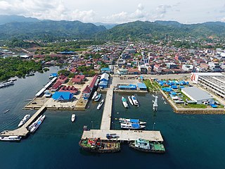
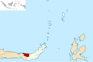
Mamuju Regency is a regency of West Sulawesi province, Indonesia. The regency capital is at Karema, while Mamuju town is the capital of West Sulawesi. The population of the regency was 336,879 at the 2010 Census, but it was substantially reduced by the creation of the new Central Mamuju Regency which was cut out of it on 14 December 2012. The reduced Mamuju Regency covers an area of 4,979.89 km2 and had a population of 278,764 at the 2020 Census; the official estimate as at mid 2023 was 292,395.

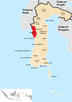
Polewali Mandar is one of the five regencies in West Sulawesi province of Indonesia. It borders on the regencies of Mamasa in the North, Majene in the West and Pinrang regency of South Sulawesi in the East. It covers an area of 2,074.76 km2 and had a population of 396,120 at the 2010 Census and 478,534 at the 2020 Census; the official estimate as at mid 2023 was 495,371. The regency is inhabited by various ethnic groups such as the Mandar, Buginese, Javanese and Toraja.
Supiori Regency is a regency in the Indonesian province of Papua. The Regency has an area of 634.24 km2 including the Aruri Islands group to the south, and had a population of 15,874 at the 2010 Census and 22,547 at the 2020 Census; the official estimate as at mid 2022 was 23,247 - comprising 12,056 males and 11,191 females. Until 8 January 2004, this area was part of the Biak Numfor Regency, from which it was split off in accordance with the Law dated 18 December 2003.

Sitaro Islands Regency is a regency located off the northern extremity of Sulawesi Island in the southern Sangihe Islands, North Sulawesi Province, Indonesia. The regency was formed under Law Number 15 Year 2007 from 2 January 2007, by separation from the Sangihe Islands Regency of which it had previously formed the southern part. The short form of the name is formed from one syllable from each of the names of the three principal islands — Siau, Tagulandang and Biaro.
Central Halmahera Regency is a regency of North Maluku Province, Indonesia. The regency was originally formed on 15 August 1990 from part of the former North Maluku Regency, but on 25 February 2003 parts of the new regency were split off to form a separate East Halmahera Regency and the city of Kota Tidore Kepulauan. It now comprises just the southern half of the southeastern peninsula of Halmahera Island, together with part of the southern peninsula of that island.

Paser Regency is the southernmost regency (kabupaten) within the East Kalimantan province of Indonesia. It was created in 1959, originally spelt "Pasir Regency", but renamed "Paser" in 2007; however its northeastern districts were split off on 10 April 2002 to form the new Penajam North Paser Regency. The residual regency covers an area of 11,603.94 km2, and it had a population of 230,316 at the 2010 Census and 275,452 at the 2020 Census; the official estimate as at mid-2023 was 303,424. Its administrative centre is the town of Tana Paser.

Pasangkayu Regency is one of the six regencies which comprise West Sulawesi Province, Indonesia, on the island of Sulawesi. It covers an area of 3,043.75 km2 and had a population of 134,303 at the 2010 Census and 188,861 at the 2020 Census. The official estimate as at mid 2023 was 204,216. The town of Pasangkayu is the capital and chief town of the regency.
Sukamara Regency is one of the thirteen regencies which comprise the Central Kalimantan Province on the island of Kalimantan (Borneo), Indonesia. It was created on 10 April 2002 from the former southwest part of West Kotawaringin Regency. The town of Sukamara is the capital of Sukamara Regency, which covers an area of 3,827 km2. The population of the Regency was 44,952 at the 2010 Census and 63,464 at the 2020 Census; the official estimate as at mid 2023 was 66,633.

Bantaeng Regency is a regency of South Sulawesi Province in Indonesia. It covers an area of 395.83 km2 and had a population of 176,984 at the 2010 Census, rising to 196,716 at the 2020 Census. The official estimate as at mid 2023 was 211,623. The administrative centre is the town of Bantaeng, which lies on the south coast of the southern peninsula of Sulawesi island.

Barru Regency is a regency of South Sulawesi province of Indonesia. It covers an area of 1,174.72 km2 and had a population of 165,983 at the 2010 Census and 184,452 at the 2020 Census. The official estimate of population as of mid-2023 was 194,543. The principal town lies at Barru.

Enrekang Regency is an inland regency of South Sulawesi Province of Indonesia. It covers an area of 1,821.53 km2 and had a population of 190,175 at the 2010 census and 225,172 at the 2020 census; the official estimate as at mid 2023 was 231,301. The principal town lies at Enrekang.

Takalar Regency is a regency of South Sulawesi Province, Indonesia. It covers an area of 566.51 km2 and had a population of 269,603 at the 2010 census and 300,853 at the 2020 census; the official estimate for mid 2023 was 326,044. The entire regency lies within the official metropolitan area of the city of Makassar. The principal towns are at Galesong and Takalar, but the administrative centre is at Pattallassang.
Kolaka Regency is a regency of Southeast Sulawesi Province, Indonesia. It covers an area of 2,960.73 km2 (1,143.14 sq mi) and had a population of 208,817 at the 2010 Census, rising to 237,587 at the 2020 Census; the official estimate as at mid 2023 was 247,680. The principal town lies at Kolaka.

South Konawe Regency is a regency of Southeast Sulawesi Province, Indonesia. The regency was created on 25 February 2003 from what had been the southern districts of Konawe Regency. It covers an area of 4,237.74 km2 and had a population of 264,587 at the 2010 Census and of 308,524 at the 2020 Census; the official estimate as at mid 2023 was 322,946 - comprising 165,487 males and 157,459 females.< The administrative centre is in the town of Andoolo.

Tolitoli Regency is a regency of Central Sulawesi Province of Indonesia. It was previously part of a larger Buol Tolitoli Regency, but this was split into two on 4 October 1999 after rapid decentralization of the Indonesian government. The present Tolitoli Regency covers an area of 3,701.54 km2 and had a population of 211,296 at the 2010 Census and 225,154 at the 2020 Census; the official estimate as at mid 2023 was 231,711, comprising 118,180 male and 113,530 female inhabitants. Its regency seat is located at the town of Tolitoli, which is a port town and where the regency's population is concentrated.
North Bolaang Mongondow Regency is a regency of North Sulawesi Province of Indonesia. It was created on 2 January 2007 by splitting off districts which had previously been the western part of Bolaang Mongondow Regency. The regency covers an area of 1,672.61 km2 and had a population of 70,693 at the 2010 Census and 83,112 at the 2020 Census; the official estimate as at mid 2023 was 86,111. Bitauna is the only official town (kelurahan) in the regency, but the administrative centre is at Boroko.

North Minahasa Regency is a regency in North Sulawesi, Indonesia. Its capital is Airmadidi. It was originally part of the Minahasa Regency until it was split off and established as a separate regency on 20 November 2003. It covers an area of 1,059.24 km2, and had a population of 188,904 at the 2010 Census; this had risen to 224,993 at the 2020 Census, and the official estimate as at mid 2023 was 231,791. The Regency includes the offshore islands of Bangka and Talisei to the north of Sulawesi, and Mantenang and Naeng Besar to the northwest.

South Minahasa Regency is a regency in North Sulawesi, Indonesia. Its capital is the town of Amurang. It was originally part of the Minahasa Regency until it was established as a separate regency on 25 February 2003. In turn, nearly four years later, a new Southeast Minahasa Regency was established as a separate regency from part of the South Minahasa Regency on 2 January 2007. The residual Regency now covers an area of 1,456.74 km2, and had a population of 195,553 at the 2010 Census; this had risen to 236,463 at the 2020 Census; the official estimate as at mid 2023 was 244,590.

Southeast Minahasa Regency is a regency in North Sulawesi, Indonesia. It covers a land area of 730.63 km2, and had a population of 100,443 at the 2010 Census; this had risen to 116,323 at the 2020 Census, and the official estimate as at mid 2023 was 118,946. It was established as a separate regency from the south-eastern part of the South Minahasa Regency on 2 January 2007. Its administrative centre is at the town of Ratahan.