
Stonehenge is a prehistoric monument on Salisbury Plain in Wiltshire, England, two miles (3 km) west of Amesbury. It consists of an outer ring of vertical Sarsen standing stones, each around 13 feet (4.0 m) high, seven feet (2.1 m) wide, and weighing around 25 tons, topped by connecting horizontal lintel stones. Inside is a ring of smaller bluestones. Inside these are free-standing trilithons, two bulkier vertical Sarsens joined by one lintel. The whole monument, now ruinous, is oriented towards the sunrise on the Summer solstice. The stones are set within earthworks in the middle of the most dense complex of Neolithic and Bronze Age monuments in England, including several hundred tumuli.
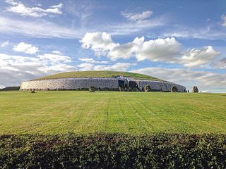
Newgrange is a prehistoric monument in County Meath, Ireland, located 8 kilometres (5.0 mi) west of Drogheda on the north side of the River Boyne. It is an exceptionally grand passage tomb built during the Neolithic period, around 3200 BC, making it older than Stonehenge and the Egyptian pyramids.
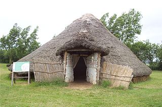
Flag Fen, east of Peterborough, England, is a Bronze Age site developed about 3500 years ago, consisting of more than 60,000 timbers arranged in five very long rows, creating a wooden causeway across the wet fenland. Part-way across the structure a small island was formed. Items associated with it have led scholars to conclude that the island was of religious significance. Archaeological work began in 1982 at the site, which is located 800 m east of Fengate. Flag Fen is now part of the Greater Fens Museum Partnership. A visitor centre has been constructed on site and some areas have been reconstructed, including a typical Iron Age roundhouse dwelling.

There are three related types of Neolithic earthwork that are all sometimes loosely called henges. The essential characteristic of all three is that they feature a ring-shaped bank and ditch, with the ditch inside the bank. Because the internal ditches would have served defensive purposes poorly, henges are not considered to have been defensive constructions. The three henge types are as follows, with the figure in brackets being the approximate diameter of the central flat area:
- Henge (> 20 m). The word henge refers to a particular type of earthwork of the Neolithic period, typically consisting of a roughly circular or oval-shaped bank with an internal ditch surrounding a central flat area of more than 20 m (66 ft) in diameter. There is typically little if any evidence of occupation in a henge, although they may contain ritual structures such as stone circles, timber circles and coves. Henge monument is sometimes used as a synonym for henge. Henges sometimes, but by no means always, featured stone or timber circles, and circle henge is sometimes used to describe these structures. The three largest stone circles in Britain are each within a henge. Examples of henges without significant internal monuments are the three henges of Thornborough Henges. Although having given its name to the word henge, Stonehenge is atypical in that the ditch is outside the main earthwork bank.
- Hengiform monument (5 – 20 m). Like an ordinary henge, except the central flat area is between 5 and 20 m (16–66 ft) in diameter, they comprise a modest earthwork with a fairly wide outer bank. The terms Mini henge or Dorchester henge are sometimes used as synonyms for hengiform monument. An example is the Neolithic site at Wormy Hillock Henge.
- Henge enclosure (> 300 m). A Neolithic ring earthwork with the ditch inside the bank, with the central flat area having abundant evidence of occupation and usually being more than 300 m (980 ft) in diameter. Some true henges are as large as this, but lack evidence of domestic occupation. Super henge is sometimes used as a synonym for a henge enclosure. However, sometimes Super henge is used to indicate size alone rather than use, e.g. "Marden henge ... is the least understood of the four British 'superhenges' ".

Avebury is a Neolithic henge monument containing three stone circles, around the village of Avebury in Wiltshire, in southwest England. One of the best known prehistoric sites in Britain, it contains the largest megalithic stone circle in the world. It is both a tourist attraction and a place of religious importance to contemporary pagans.

A stone circle is a circular alignment of standing stones. They are commonly found across Northern Europe and Great Britain, and typically date from the Late Neolithic and Early Bronze Age eras, with most concentrations appearing from 3000 BC. The best known examples include those at the henge monument at Avebury, the Rollright Stones, and elements within the ring of standing stones at Stonehenge. Ancient stone circles appear throughout Europe, with many existing in the Pyrenees, on the Causse de Blandas in southern France in the Cevennes, in the Alps, Bulgaria, and Poland. Another type can be found in the Horn of Africa.

Durrington Walls is the site of a large Neolithic settlement and later henge enclosure located in the Stonehenge World Heritage Site in England. It lies 2 miles (3.2 km) north-east of Stonehenge in the parish of Durrington, just north of Amesbury. The henge is the second-largest Late Neolithic palisaded enclosure known in the United Kingdom, after Hindwell in Wales.
The Thornborough Henges are an unusual ancient monument complex that includes the three aligned henges that give the site its name. The complex is located near the village of Thornborough, close to the town of Masham in North Yorkshire, England. The complex includes many large ancient structures including a cursus, henges, burial grounds and settlements.

Bryn Celli DduWelsh pronunciation: [brʌn keːɬi ðɨː] is a prehistoric site on the Welsh island of Anglesey located near Llanddaniel Fab. Its name means 'the mound in the dark grove'. It was archaeologically excavated between 1928 and 1929. Visitors can get inside the mound through a stone passage to the burial chamber, and it is the centrepiece of a major Neolithic Scheduled Monument in the care of Cadw. The presence of a mysterious pillar within the burial chamber, the reproduction of the 'Pattern Stone', carved with sinuous serpentine designs, and the fact that the site was once a henge with a stone circle, and may have been used to plot the date of the summer solstice have all attracted much interest.

Archaeology and geology continue to reveal the secrets of prehistoric Scotland, uncovering a complex past before the Romans brought Scotland into the scope of recorded history. Successive human cultures tended to be spread across Europe or further afield, but focusing on this particular geographical area sheds light on the origin of the widespread remains and monuments in Scotland, and on the background to the history of Scotland.

Cairnpapple Hill is a hill with a dominating position in central lowland Scotland with views from coast to coast. It was used and re-used as a major ritual site over about 4000 years, and in its day would have been comparable to better known sites like the Standing Stones of Stenness. The summit lies 312 m above sea level, and is about 2 miles (3 km) north of Bathgate. In the 19th century the site was completely concealed by trees, then in 1947–1948 excavations by Stuart Piggott found a series of ritual monuments from successive prehistoric periods. In 1998, Gordon Barclay re-interpreted the site for Historic Scotland. It is designated a scheduled ancient monument.

Brú na Bóinne or Boyne valley tombs, is an area in County Meath, Ireland, located in a bend of the River Boyne. It contains one of the world's most important prehistoric landscapes dating from the Neolithic period, including the large Megalithic passage graves of Knowth, Newgrange and Dowth as well as some 90 additional monuments. The archaeological culture associated with these sites is called the "Boyne culture".

Mayburgh Henge is a large prehistoric monument in the county of Cumbria in northern England. The henge is in the care of English Heritage and is a Scheduled Ancient Monument. It is 400 metres from King Arthur's Round Table Henge.
The stone circles in the British Isles and Brittany are a megalithic tradition of monuments consisting of standing stones arranged in rings. These were constructed from 3300 to 900 BCE in Britain, Ireland and Brittany. It has been estimated that around 4,000 of these monuments were originally constructed in this part of north-western Europe during this period. Around 1,300 of them are recorded, the others having been destroyed.

The architecture of Scotland in the prehistoric era includes all human building within the modern borders of Scotland, before the arrival of the Romans in Britain in the first century BCE. Stone Age settlers began to build in wood in what is now Scotland from at least 8,000 years ago. The first permanent houses of stone were constructed around 6,000 years ago, as at Knap of Howar, Orkney and settlements like Skara Brae. There are also large numbers of chambered tombs and cairns from this era, particularly in the west and north. In the south and east there are earthen barrows, often linked to timber monuments of which only remnants remain. Related structures include bank barrows, cursus monuments, mortuary enclosures and timber halls. From the Bronze Age there are fewer new buildings, but there is evidence of crannogs, roundhouses built on an artificial islands and of Clava cairns and the first hillforts. From the Iron Age there is evidence of substantial stone Atlantic roundhouses, which include broch towers, smaller duns. There is also evidence of about 1,000 hillforts in Scotland, most located below the Clyde-Forth line.

Hillforts in Scotland are earthworks, sometimes with wooden or stone enclosures, built on higher ground, which usually include a significant settlement, built within the modern boundaries of Scotland. They were first studied in the eighteenth century and the first serious field research was undertaken in the nineteenth century. In the twentieth century there were large numbers of archaeological investigations of specific sites, with an emphasis on establishing a chronology of the forts. Forts have been classified by type and their military and ritual functions have been debated.

Prehistoric Cumbria describes that part of north-west England, subsequently the county of Cumbria, prior to the coming of the Romans. Barrowclough puts the archaeological record of the county at '443 stone tools, 187 metal objects and 134 pots', plus the various monuments such as henges, stone circles, and the like. The survival of these objects has been influenced by processes such as the rise in sea levels on the west coast, erosion, deposition practices, industrial and agricultural development, and the changing interests and capabilities of antiquarians and archaeologists.

Falkner's Circle was a stone circle near the village of Avebury in the south-western English county of Wiltshire. Built from twelve sarsen megaliths, it measured about 37 metres (121 ft) in diameter, although only one of these stones remains standing. The ring was part of a tradition of stone circle construction that spread throughout much of Britain, Ireland, and Brittany during the Late Neolithic and Early Bronze Age, over a period between 3300 and 900 BCE. The purpose of such monuments is unknown, although archaeologists speculate that the stones represented supernatural entities for the circle's builders.

The Catholme ceremonial complex is an archaeological site of the Neolithic period in Staffordshire, England, near Barton-under-Needwood. It is a scheduled monument.