
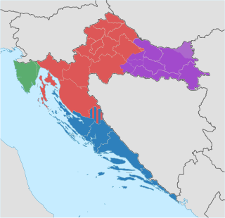
Podravina (in Croatian) or Podravje (in Slovenian) are Slavic names for the Drava river basin in Croatia and Slovenia.
Podravina (in Croatian) or Podravje (in Slovenian) are Slavic names for the Drava river basin in Croatia and Slovenia.
Between 1929 and 1941 a province of the Kingdom of Yugoslavia known as the Drava Banovina (Drava province) existed in the area with its capital in Ljubljana. The Drava Banovina comprised most of present-day Slovenia.
Today, one of the counties in Croatia is named Virovitica-Podravina, however the official capital of the region is the city of Koprivnica which is also the capital of Koprivnica-Križevci County. [1]
Cities and towns in Slovenia:
Cities and towns in Croatia:
The state route D2 connects all Croatian towns in Podravina.

Varaždin County is a county in northern Croatia. It is named after its county seat, the city of Varaždin.
Koprivnica-Križevci County is a county in northern Croatia. Its hyphenated name comes from two entities: the two of its largest cities, Koprivnica and Križevci; Koprivnica is the official capital of the county.
Bjelovar-Bilogora County is a county in central Croatia.

Virovitica-Podravina County is a northern Slavonian county in Croatia. Its county seat is in Virovitica and it includes the area around the Drava river, hence the name Podravina. Other notable towns are Slatina and Orahovica.
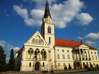
Križevci is a city in central Croatia with a total population of 21,122 and with 11,231 in the city itself (2011), the oldest city in its county, the Koprivnica-Križevci County.

Koprivnica is a city in northern Croatia. It is the capital of the Koprivnica-Križevci county. In 2011, the city's administrative area of 90.94 km2 had a total population of 30,854, with 23,955 in the city proper.

Somogy is an administrative county in present Hungary, and also in the former Kingdom of Hungary.

The Bjelovar-Križevci County was a historic administrative subdivision (županija) of the Kingdom of Croatia-Slavonia. Croatia-Slavonia was an autonomous kingdom within the Lands of the Crown of Saint Stephen (Transleithania), the Hungarian part of the dual Austro-Hungarian Empire. Its territory is now in northern Croatia. Belovár and Kőrös are the Hungarian names for the cities Bjelovar and Križevci, respectively. The capital of the county was Bjelovar.
Legrad is a municipality in northern Croatia, located north of Koprivnica and east of Ludbreg in the Koprivnica–Križevci County. There are 2,241 inhabitants in the municipality, absolute majority of which are Croats at 97.4%, with the largest minority being Romani at 1% of the municipality. Beside the Roman Catholic majority, there are Hungarian and Croatian Lutherans that have a tradition beginning in the 16th century.
Horvat is a surname of Croatian origin. It is the most frequent surname in Croatia and the second most frequent in Slovenia. Its variant Horvath is very frequent in Hungary and Slovakia.
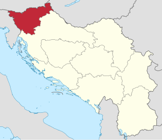
The Drava Banovina or Drava Banate, was a province (banovina) of the Kingdom of Yugoslavia between 1929 and 1941. This province consisted of most of present-day Slovenia and was named for the Drava River. The capital city of the Drava Banovina was Ljubljana.
The Republic of Croatia is administratively organised into twenty counties, and is also traditionally divided into four historical and cultural regions: Croatia Proper, Dalmatia, Istria, and Slavonia. These are further divided into other, smaller regions.
The subdivisions of Croatia on the first level are the 20 counties and one city-county.

The following outline is provided as an overview of and topical guide to Croatia:
The Danube–Drava–Sava Euroregion is a Euroregion comprising areas of the countries of Bosnia and Herzegovina, Croatia and Hungary. It was established in 1998. The president of the organization is Ferenc Kékes.

D2 state road is a trunk state road in the northern areas of Croatia that spans from the border crossing with Slovenia at Dubrava Križovljanska in the west via Varaždin, Koprivnica, Virovitica, Našice, Osijek, Vukovar, ending at the Ilok–Bačka Palanka Bridge border crossing with Serbia. The road is 347.9 km (216.2 mi) long.
Bilogora is a low mountainous range in Central Croatia. It consists of a series of hills and small plains some 80 kilometres in length stretching in the direction northwest-southeast, along the southwest part of the Podravina region. The highest peak is called Rajčevica, located in the north of the mountain.
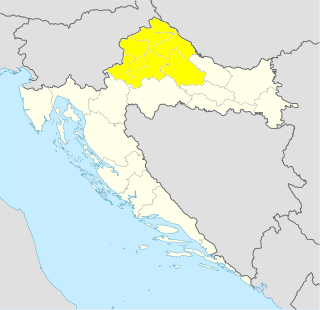
Northern Croatia or North Croatia is a region in the northern part of Croatia, which encompasses Varaždin, Međimurje, Zagorje and Koprivnica-Križevci counties, including the cities of Varaždin, Čakovec, Krapina, Koprivnica and Križevci. The Kajkavian dialect is spoken there. It shares borders with Hungary and Slovenia.

The 4th Army was a Royal Yugoslav Army formation mobilised prior to the German-led Axis invasion of the Kingdom of Yugoslavia during World War II. It was drawn from the peacetime 4th Army District. When mobilised, it consisted of three divisions, a brigade-strength detachment, one horse cavalry regiment and one independent infantry regiment. It formed part of the 1st Army Group, and was responsible for defending a large section of the Yugoslav–Hungarian border, being deployed behind the Drava river between Varaždin and Slatina. Like all Yugoslav formations at the time, the 4th Army had serious deficiencies in both mobility and firepower.
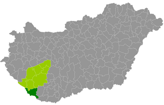
Barcs is a district in southern part of Somogy County. Barcs is also the name of the town where the district seat is found. The district is located in the Southern Transdanubia Statistical Region.
Coordinates: 46°34′5.36″N15°36′2.26″E / 46.5681556°N 15.6006278°E
| Principal historical regions |  | ||||||||
|---|---|---|---|---|---|---|---|---|---|
| Smaller regions |
| ||||||||
| | This Central Croatian geography article is a stub. You can help Wikipedia by expanding it. |
| | This Slavonian geography article is a stub. You can help Wikipedia by expanding it. |
| | This Slovenian geography article is a stub. You can help Wikipedia by expanding it. |