Point Pleasant Park

Last updated
Point Pleasant Park
Point Pleasant.jpg
Point Pleasant Park
Point Pleasant Park
TypePublic park
Location Halifax, Nova Scotia
Coordinates 44°37′22″N63°34′9″W / 44.62278°N 63.56917°W / 44.62278; -63.56917
Area75 ha (190 acres)
Created1866
Operated by Halifax Regional Municipality (Land under lease from Government of Canada)

Point Pleasant Park is a large, mainly forested municipal park at the southern tip of the Halifax peninsula. It once hosted several artillery batteries, and still contains the Prince of Wales Tower - the oldest Martello tower in North America (1796). [1] The park is a popular recreational spot for Haligonians, as it hosts forest walks and affords views across the harbour and out toward the Atlantic.

Contents

Plays are performed in the park every summer by a professional theatre company called Shakespeare by the Sea. The performances take place at Cambridge Battery, and include both Shakespearean productions and original musicals based on classic fairy tales for audiences of all ages. The company also operates the 80-seat Park Place Theatre in the lower parking lot of the park, which is used as a rain venue during the summer, and for fall/winter indoor productions.

Point Pleasant Park originally was owned by the British government [2] and was leased to the City of Halifax for a ceremonial 1 shilling per year. The original lease for the land was negotiated by Sir William Young in 1866. The park is now owned by the Governemnt of Canada and is leased to the Halifax Regional Municipality. The lease for the park is administered on behalf of the Government of Canada by the Parks Canada Agency. [3]

History

18th-19th century

St. Aspinquid Chapel

St. Aspinquid's Chapel was established by Priest Louis-Pierre Thury at Chebucto (present day Halifax, Nova Scotia) in the late 17th century. The chapel is a natural stone amphitheatre located by Chain Rock Battery on the Northwest Arm at Point Pleasant Park. There are numerous notable people who were interred in the burial grounds around the chapel. The chapel was also the location of the Mi’kmaq celebration the Feast of St. Aspinquid (St. Aspinquid's Day), which was conducted through much of the 18th century. The Chapel is also the site of a battle during the French and Indian War between two Mi'kmaq chiefs (1760).

Establishing Halifax

In 1749, Edward Cornwallis arrived under instruction of the British Government to create a sizeable military and civilian settlement of 4000 in Halifax which sparked Father Le Loutre's War. He first settled Point Pleasant Park but then, being too exposed to the elements, moved the settlement below Citadel Hill. [4] Halifax was to become a strategic settlement for the British and fortifications were primarily intended to prevent enemy ships from getting into the Halifax Harbour. Fortifications began to be constructed at present-day Point Pleasant Park toward the end of the French and Indian War.

There were a total of seven fortifications constructed: Chain Rock, Chain Battery, Point Pleasant Battery, Northwest Arm Battery, Fort Ogilvie, Prince of Wales Tower and Cambridge Battery. Most were rebuilt or modified four or five times over the subsequent 200 years.

French and Indian War

There were four defences that were constructed during the French and Indian War: Chain Battery, Chain Rock, Point Pleasant Battery and Northwest Arm Battery. The defences were built of logs, earth, and stone. They were built with wood-burning fireplaces, and furnaces were later added for smelting cannon shot. Chain Battery and Chain Rock were basic fortifications built on the natural terrain to protect the Northwest Arm. Unlike most of the other fortifications, the battery here was not rebuilt in the 19th century, so it retains its original 1762 layout. Because it was abandoned so early, the area has been reforested for most of the historic period. Point Pleasant Battery is one of the oldest fortification batteries. Though Point Pleasant Battery was first constructed in 1762, what is visible today dates mostly from the early 20th century. The fourth battery - the Northwest Arm Battery - was built during the war, just west of Point Pleasant, was damaged in 1895 and was falling into the sea. It was moved further along the Northwest Arm shore. Northwest Arm Battery was first built in 1762 and disused after the 1860s. Archeological remains associated with its barracks include a summer house built for the Park in the 1880s. The battery here retains its early 19th century configuration.

French Revolutionary Wars

Prince of Wales Tower - oldest Martello Tower in North America (1796), Point Pleasant Park Halifax Nova Scotia MartelloTowerPointPleasantParkHalifaxNovaScotia.jpg
Prince of Wales Tower - oldest Martello Tower in North America (1796), Point Pleasant Park Halifax Nova Scotia

In 1792, during the French Revolutionary Wars, the threat of an immediate French attack alerted the British military in Halifax to the possibility of a landing in the harbour and batteries were upgraded and improved. Fort Ogilvie was built at this time and is located in the eastern part of Point Pleasant Park. It was built by the order of General Ogilvie, then commander of the Halifax garrison. Ogilvie named the battery after himself.

In 1796-97, a battery was built on high ground behind the point at a location capable of defending the point batteries. A few years later, the battery was converted to a large round stone tower known as the Prince of Wales Tower, similar to the Martello Towers built in large numbers elsewhere by the British military. The Prince of Wales Tower is 26 feet high and is 72 feet in diameter. The exposed material is ironstone rubble masonry, with 8-foot-thick (2.4 m) walls. The original construction permitted six mounted guns on the roof and four guns on the second storey.

Further modifications were made over the next seventy years. By 1813, the Tower mounted four 6-pound guns on garrison carriages on its barrack level, two 24-pound guns on traversing platforms and six 24-pound carronades on traversing slides on top. After 1864, the Tower was used as a self-defensible depot magazine.

The park was the site of several small farms during the early settlement of Halifax. A rock outcropping at Black Rock Beach was used to gibbet the bodies of executed criminal such as the pirate Edward Jordan in 1809.

Cambridge Battery is situated back from the Point Pleasant and Northwest Arm batteries along the shore. It was approved in 1862 and completed in 1868. The battery was named in honour of the Duke of Cambridge, who was the head of the military during much of Queen Victoria's reign.

20th century

Halifax Memorial, dedicated to the Canadian servicemen and women who died at sea during both World Wars and includes the Royal Canadian Navy, the Canadian Merchant Navy and the Canadian Army Halifax memorial.jpg
Halifax Memorial, dedicated to the Canadian servicemen and women who died at sea during both World Wars and includes the Royal Canadian Navy, the Canadian Merchant Navy and the Canadian Army
Halifax Memorial, Point Pleasant Park, Halifax, Nova Scotia Halifax Memorial, Point Pleasant Park, Halifax, Nova Scotia.jpg
Halifax Memorial, Point Pleasant Park, Halifax, Nova Scotia

The Cambridge Battery was abandoned by the time of the First World War.

In 1929, the military temporarily vacated the park before returning in 1938 during the Second World War. Although the Martello tower ceased to be important for military purposes in the late 19th century, some of the other fortifications in the Park continued to be used by the military until the close of the Second World War. Fort Ogilvie and Cambridge Battery were upgraded with modern weapons during the Second World War. A gun from this era is still visible at Fort Ogilvie.

Small amounts of stone were quarried in the park in the 19th century, the small quarries today forming a pond near the park entrance. In the 1920s, the Halifax streetcar line was extended into the park as far as the Prince of Wales Tower but the route was abandoned in the 1940s.

The park was the target of a "group" calling itself "Loki 7" in 1994, when they planted a pipe bomb in a garbage bin. Nobody was injured.

In 1943 a large Canadian steamship, SS Point Pleasant Park, was named after the park. The mayor of Halifax presented the ship's captain with a framed picture of the Yonge Street gate which was displayed in the dining room aboard the ship until it was torpedoed in 1945. [5]

Point Pleasant Park during winter Point pleasant park.jpg
Point Pleasant Park during winter

In 2000 the Canadian Food Inspection Agency planned to cut 10,000 trees to halt an outbreak of Brown Spruce Longhorn Beetle (Tetropium fuscum). This plan was challenged by the Friends of Pt. Pleasant Park in the courts, which resulted in a temporary injunction stopping the cutting. The injunction was later removed but there was a reduction in tree cutting to less than 2000.

21st century

Point Pleasant Park June 2016.jpg
Entrance to Prince of Wales Tower, June 2016, showing only partial reforestation. Prior to Hurricane Juan in 2003 it was covered by a dense canopy of trees - see identical image before hurricane and also the same view after the hurricane

In September 2003, Point Pleasant Park was devastated by Hurricane Juan. Nearly three quarters of the park's trees were knocked down and the park remained closed until June 2004. While there were still trees remaining, the park now had a very thin canopy.

Assistance from the Canadian federal government allowed Halifax Regional Municipality to make significant progress in the recovery and renewal of the park. As of June 2008 over 70,000 Acadian forest trees had been planted in the park, surpassing the number of trees lost to Hurricane Juan.

The comprehensive plan for Point Pleasant Park proposed long-term care for the park's forest based on Canada's national standard for sustainable forest management. The process of Adaptive Management would be used to guide the renewal and care of Point Pleasant, one of Canada's oldest urban parks.

Military monuments

HMCS Bonaventure's anchor monument Halifaxcarrier.jpg
HMCS Bonaventure's anchor monument

Point Pleasant is the location to numerous monuments associated with the heritage of Halifax and the sea. The largest is the Halifax Monument, better known as the Sailor's Memorial, which commemorates members of the Royal Canadian Navy, the Canadian Merchant Navy and Canadian Army who were lost at sea. It was first erected in 1924 in a headland near the park but moved to Citadel Hill in 1954 when names from World War II were added. However the cross on Citadel Hill had decayed by 1966 so it was replaced in 1967 by the present monument in Point Pleasant. [6] The current memorial consists of a Cross of Sacrifice inscribed with the names of 3257 Canadian men and women who were buried at sea as a result of the World Wars. The most well-known casualties listed on the monument are the nursing sisters who died on the HMHS Llandovery Castle during World War 1. (415 Canadians from naval and merchant ships who died in the Atlantic Ocean during World War I.) The original monument has been replaced by two later monuments. [7]

SS Point Pleasant Park Monument, Point Pleasant Park, Halifax, Nova Scotia, Canada SS Point Pleasant Park Monument, Point Pleasant Park, Halifax, Nova Scotia.jpg
SS Point Pleasant Park Monument, Point Pleasant Park, Halifax, Nova Scotia, Canada

The ship's anchor from the aircraft carrier HMCS Bonaventure serves as a monument to the men and women who died while serving the Canadian Navy during Peacetime. A cairn marks the lives lost in the sinking of the Canadian Merchant Navy ship SS Point Pleasant Park in 1945. A monument facing the Northwest Arm honour Walter Hose, a naval commander who helped build the Royal Canadian Navy while another honours the families who ran the Northwest Arm ferry and performed many rescues. National Historic Site plaques in the park commemorate the role of Halifax as Naval Port and the Battle between HMS Shannon and USS Chesapeake in 1813.

Flora

Trees include: [8] [9]

Shrubs include:

Ferns and mosses include:

Wildflowers include:

Transportation

Point Pleasant Park is served by Halifax Transit's route "29 Barrington", which terminates at a turning loop at the Tower Road entrance of the park. [13]

See also

Related Research Articles

<span class="mw-page-title-main">Citadel Hill (Fort George)</span> Historic site in Nova Scotia, Canada

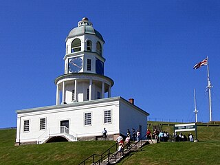
Citadel Hill is a hill that is a National Historic Site in Halifax, Nova Scotia, Canada. Four fortifications have been constructed on Citadel Hill since the city was founded by the English in 1749, and were referred to as Fort George—but only the third fort was officially named Fort George. According to General Orders of October 20, 1798, it was named after King George III. The first two and the fourth and current fort, were officially called the Halifax Citadel. The last is a concrete star fort.

<span class="mw-page-title-main">Fortress of Louisbourg</span> 18th-century French fortress on Cape Breton Island, Nova Scotia, Canada

The Fortress of Louisbourg is a tourist attraction as a National Historic Site and the location of a one-quarter partial reconstruction of an 18th-century French fortress at Louisbourg on Cape Breton Island, Nova Scotia. Its two sieges, especially that of 1758, were turning points in the Anglo-French struggle for what today is Canada.

<span class="mw-page-title-main">Hurricane Juan</span> Category 2 Atlantic hurricane in 2003

Hurricane Juan was a significant tropical cyclone which caused extensive damage to parts of Atlantic Canada, being the tenth named storm and the sixth hurricane of the 2003 Atlantic hurricane season. Juan formed southeast of Bermuda on September 24 from a tropical wave that had tracked across the subtropical Atlantic Ocean. It tracked northward and strengthened over the warm waters of the Gulf Stream, reaching Category 2 strength on the Saffir-Simpson hurricane scale on September 27. The hurricane peaked in intensity with sustained winds of 105 mph (169 km/h) that same day, losing some strength as it raced over cooler waters toward the coast of Nova Scotia, before making landfall between Shad Bay and Prospect in the Halifax Regional Municipality early on September 29 as a Category 2 hurricane with winds of 100 mph (160 km/h). Juan retained hurricane strength while travelling through Nova Scotia, though it would weaken into a Category 1 hurricane over Prince Edward Island. Juan would eventually be absorbed by another extratropical low on September 29 near Anticosti Island in the northern Gulf of Saint Lawrence.

<span class="mw-page-title-main">Shakespeare by the Sea, Halifax</span>

Shakespeare by the Sea is a professional theatre company and registered charitable society in Halifax, Nova Scotia.

<span class="mw-page-title-main">Sir Sandford Fleming Park</span> Park in Halifax, Nova Scotia

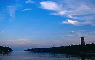
Sir Sandford Fleming Park is a 95-acre (38 ha) Canadian urban park located in the community of Jollimore in Halifax Regional Municipality. It is also known as Dingle Park or simply The Dingle, named after the town of Dingle in southwestern Ireland. The park was donated to the people of Halifax by Sir Sandford Fleming. The centrepiece of the park is an impressive tower that commemorates Nova Scotia's achievement of representative government in 1758. Constructed between 1908 and 1912, the Memorial Tower was erected during the same period of building other commemorative towers in the British Commonwealth, notably Cabot Tower in Bristol, England (1898) and Cabot Tower in St. John's (1900).

<span class="mw-page-title-main">Halifax Peninsula</span> Place in Nova Scotia, Canada

The Halifax Peninsula is a peninsula within the urban area of the Municipality of Halifax, Nova Scotia.

<span class="mw-page-title-main">Eastern Passage, Nova Scotia</span> Community in Nova Scotia, Canada

Eastern Passage is an unincorporated suburban community in Halifax Regional Municipality Nova Scotia, Canada.

<span class="mw-page-title-main">Northwest Arm</span> Inlet in Halifax, Nova Scotia, Canada

The Northwest Arm, originally named Sandwich River, is an inlet in eastern Canada off the Atlantic Ocean in Nova Scotia's Halifax Regional Municipality.

<span class="mw-page-title-main">History of Halifax, Nova Scotia</span> Aspect of history

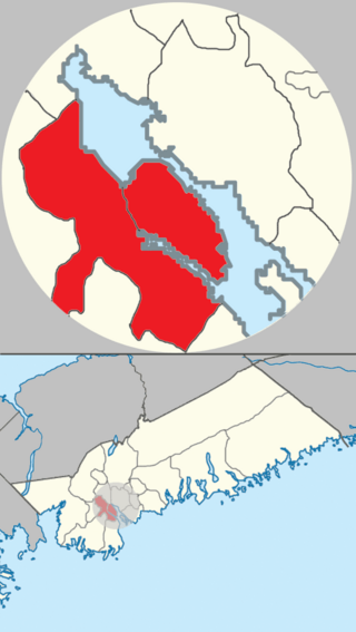
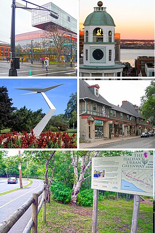
The community of Halifax, Nova Scotia was created on 1 April 1996, when the City of Dartmouth, the City of Halifax, the Town of Bedford, and the County of Halifax amalgamated and formed the Halifax Regional Municipality. The former City of Halifax was dissolved, and transformed into the Community of Halifax within the municipality.

Lieutenant-General William Spry (1734–1802) was born in Titchfield, Hampshire, in 1734, the son of George Spry and Elizabeth Short.

<span class="mw-page-title-main">McNabs Island</span> Island in Halifax Harbour in Nova Scotia, Canada

McNabs Island is the largest island in Halifax Harbour located in Halifax Regional Municipality, Nova Scotia, Canada. It played a major role in defending Halifax Harbour and is now a provincial park. The island was settled by Britons in the 1750s and later by Peter McNab, and McNab family members lived on the island until 1934.

<span class="mw-page-title-main">York Redoubt</span> Historic site in Nova Scotia, Canada

York Redoubt is a redoubt situated on a bluff overlooking the entrance to Halifax Harbour at Ferguson's Cove, Nova Scotia, Canada, originally constructed in 1793. It was designated a National Historic Site of Canada in 1962.

Canada, like several other Commonwealth nations, created the Canadian Merchant Navy in a large-scale effort during World War II. 184 ships are involved in merchant shipping activity in the Canadian shipping industry.

<span class="mw-page-title-main">Military history of Nova Scotia</span> Provincial military history

Nova Scotia is a Canadian province located in Canada's Maritimes. The region was initially occupied by Mi'kmaq. The colonial history of Nova Scotia includes the present-day Maritime Provinces and the northern part of Maine, all of which were at one time part of Nova Scotia. In 1763, Cape Breton Island and St. John's Island became part of Nova Scotia. In 1769, St. John's Island became a separate colony. Nova Scotia included present-day New Brunswick until that province was established in 1784. During the first 150 years of European settlement, the colony was primarily made up of Catholic Acadians, Maliseet, and Mi'kmaq. During the last 75 years of this time period, there were six colonial wars that took place in Nova Scotia. After agreeing to several peace treaties, the long period of warfare ended with the Halifax Treaties (1761) and two years later, when the British defeated the French in North America (1763). During those wars, the Acadians, Mi'kmaq and Maliseet from the region fought to protect the border of Acadia from New England. They fought the war on two fronts: the southern border of Acadia, which New France defined as the Kennebec River in southern Maine, and in Nova Scotia, which involved preventing New Englanders from taking the capital of Acadia, Port Royal and establishing themselves at Canso.

<span class="mw-page-title-main">Halifax Volunteer Battalion</span>

The Halifax Volunteer Battalion (1860–1868) included six companies that were raised in present-day Halifax Regional Municipality. The six companies included the Scottish Rifles, Chebucto Grays, Mayflower Rifles, Halifax Rifles, Irish Volunteers and Dartmouth Rifles which were all raised in the fall of 1859. The upper ranks of the battalion was made up of distinguished people from the community filling the ranks of officers. The battalion served ceremonial functions, raised money for charities as well as defended the city against possible military threat during the Fenian Raids. The present-day The Halifax Rifles (RCAC) descended from the 63rd regiment of the Battalion.

<span class="mw-page-title-main">Prince of Wales Tower</span>

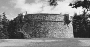
The Prince of Wales Tower is the oldest martello tower in North America and is located in Point Pleasant Park, Halifax Regional Municipality, Nova Scotia, Canada. It was built in 1796 by Captain James Straton and was used as a redoubt and a powder magazine. Restored, it was designated a National Historic Site of Canada in 1943.

<span class="mw-page-title-main">Royal Nova Scotia Regiment</span> Military unit

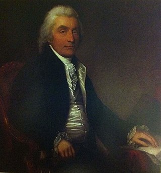
The Royal Nova Scotia Regiment was a battalion of infantry raised in 1793 to defend British interests in the colony of Nova Scotia during the Wars of the French Revolution. The unit was commanded by Colonel John Wentworth, the lieutenant-governor of the colony, throughout its existence. The Royal Nova Scotia Regiment (RNSR) had an undistinguished history through most of its existence, and saw very limited action, mostly in the role of marines, but did play an important role in the defense of Nova Scotia during these wars.

<span class="mw-page-title-main">Fort Clarence (Nova Scotia)</span>

Fort Clarence was a British coastal fort built in 1754 at the beginning of the French and Indian War in Dartmouth, Nova Scotia, Canada. The battery was built on the grant of Capt. John Rous. Governor Edward Cornwallis’ principal engineer John Brewse designed the fort which was 35 to 40 feet above sea level - at the start there was a small battery of seven 12-pounder smooth bore cannon. In spring 1759, a Mi'kmaq attack on the Eastern Battery killed five soldiers.

<span class="mw-page-title-main">Military history of the Mi'kmaq</span> Militias of Mikmaq

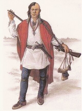
The military history of the Mi'kmaq consisted primarily of Mi'kmaq warriors (smáknisk) who participated in wars against the English independently as well as in coordination with the Acadian militia and French royal forces. The Mi'kmaq militias remained an effective force for over 75 years before the Halifax Treaties were signed (1760–1761). In the nineteenth century, the Mi'kmaq "boasted" that, in their contest with the British, the Mi'kmaq "killed more men than they lost". In 1753, Charles Morris stated that the Mi'kmaq have the advantage of "no settlement or place of abode, but wandering from place to place in unknown and, therefore, inaccessible woods, is so great that it has hitherto rendered all attempts to surprise them ineffectual". Leadership on both sides of the conflict employed standard colonial warfare, which included scalping non-combatants. After some engagements against the British during the American Revolutionary War, the militias were dormant throughout the nineteenth century, while the Mi'kmaq people used diplomatic efforts to have the local authorities honour the treaties. After confederation, Mi'kmaq warriors eventually joined Canada's war efforts in World War I and World War II. The most well-known colonial leaders of these militias were Chief (Sakamaw) Jean-Baptiste Cope and Chief Étienne Bâtard.

<span class="mw-page-title-main">St. Aspinquid's Chapel</span> Historic church in Halifax, Nova Scotia

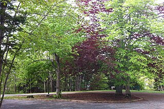
St. Aspinquid's Chapel was established by Priest Louis-Pierre Thury at Chebucto in the late 17th century. The chapel is a natural stone amphitheatre located by Chain Rock Battery on the Northwest Arm at Point Pleasant Park. There are numerous notable people interred in the burial grounds around the chapel and it is also the location of the Mi’kmaq celebration of the Feast of St. Aspinquid, which was conducted through much of the 18th century. During the French and Indian War two Mi'kmaw chiefs fought each other in a battle near the chapel (1760).

References

  1. Prince of Wales Tower National Historic Site of Canada Archived 2013-02-10 at the Wayback Machine
  2. "Nova Scotia: Point Pleasant Park". Novascotia.com. 2015. Retrieved 5 May 2016.
  3. https://www.halifax.ca/sites/default/files/documents/city-hall/boards-committees-commissions/pppcpchapter6.pdf#:~:text=Point%20Pleasant%20Park%20is%20owned,purposes%20of%20a%20municipal%20park.&text=The%20lease%20for%20the%20park,federal%20department%20of%20Environment%20Canada.
  4. Robertson 2016.
  5. "Point Pleasant Park", Halifax Herald December 15, 1943, p. 1
  6. Kitz, p. 145-146
  7. "Monuments, World Wars I and II" Archived 2011-08-10 at the Wayback Machine . Canadian Encyclopedia
  8. Schmidt & Beauchamp 2011.
  9. LaPaix & Patriquin 2012.
  10. NSWFS 2016, Aralia hispida Vent.
  11. NSWFS 2016, Nemopanthus mucronatus (L.) Loes.
  12. Landry 2011, Bluets
  13. "Routes & Schedules". Halifax Transit. Retrieved 17 February 2020.

Bibliography

Flora

Images