
Western Sahara is a disputed territory on the northwest coast of Africa. About 20% of the territory is controlled by the Sahrawi Arab Democratic Republic (SADR); the remaining 80% is occupied and administered by neighboring Morocco. It has a surface area of 266,000 square kilometres (103,000 sq mi). It is the second most sparsely populated country in the world and most sparsely in Africa, mainly consisting of desert flatlands. The population is estimated at 500,000, of which nearly 40% live in Morocco-controlled Laayoune, the largest city in Western Sahara.
Transport in Western Sahara is very limited by sea, road and air with camels being the primary means of transportation in the desert area. Road transport by buses remain the major mode of transportation. The longest conveyor belt in the world is 100 kilometres (62 mi) long, from the phosphate mines of Bu Craa to the coast south of Laayoune. The belt moves about 2,000 metric tons of rock containing phosphate every hour from the mines to El-Aaiun, where it is loaded and shipped.

Western Sahara, formerly the Spanish colony of Spanish Sahara, is a disputed territory claimed by both the Kingdom of Morocco and the Popular Front for the Liberation of the Saguia el Hamra and Rio de Oro, which is an independence movement based in Tifariti and Bir Lehlou. The Annexation of Western Sahara by Morocco took place in two stages, in 1976 and 1979, and is considered illegal under international law.

The Moroccan Western Sahara Wall or the Berm, also called the Moroccan sand wall, is an approximately 2,700 km-long (1,700 mi) berm running south to north through Western Sahara and the southwestern portion of Morocco. It separates the Moroccan-controlled areas on the west from the Polisario-controlled areas on the east. The main function of the barriers is to exclude guerrilla fighters of the Polisario Front, who have sought Western Saharan independence since before Spain ended its colonial occupation in 1975, from the Moroccan-controlled western part of the territory.

The Alfred Wegener Institute, Helmholtz Centre for Polar and Marine Research is located in Bremerhaven, Germany, and a member of the Helmholtz Association of German Research Centres. It conducts research in the Arctic, the Antarctic, and the high and mid latitude oceans. Additional research topics are: North Sea research, marine biological monitoring, and technical marine developments. The institute was founded in 1980 and is named after meteorologist, climatologist, and geologist Alfred Wegener.

Río de Oro was, with Saguia el-Hamra, one of the two territories that formed the Spanish province of Spanish Sahara after 1969; it had been taken as a Spanish colonial possession in the late 19th century. Its name seems to come from an east–west river which was supposed to have run through it. The river was thought to have largely dried out – a wadi, as the name indicates – or have disappeared underground.
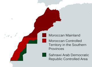
The Southern Provinces or Moroccan Sahara are the terms utilized by the Moroccan government to refer to the occupied territory of Western Sahara. These designations encompass the entirety of Western Sahara, which spans three of Morocco's 12 top-level administrative regions. The term "Southern Provinces" is frequently used on Moroccan state television.
The Independence Intifada or the Second Sahrawi Intifada and also May Intifada is a Sahrawi activist term for a series of disturbances, demonstrations and riots that broke out in May 2005 in the Moroccan-controlled parts of Western Sahara and south of Morocco. This event has also been called The El-Aaiun Intifada by the same sources.
The Western Sahara conflict is an ongoing conflict between the Sahrawi Arab Democratic Republic/Polisario Front and the Kingdom of Morocco. The conflict originated from an insurgency by the Polisario Front against Spanish colonial forces from 1973 to 1975 and the subsequent Western Sahara War against Morocco between 1975 and 1991. Today the conflict is dominated by unarmed civil campaigns of the Polisario Front and their self-proclaimed SADR state to gain fully recognized independence for Western Sahara.

Dakhla-Oued Ed-Dahab is one of the twelve regions of Morocco. Before September 2015 it was known as Oued Ed-Dahab-Lagouira. It is situated in the disputed territory of Western Sahara, considered by Morocco to be the southern part of the country. The Polisario Front and other independence-seeking Sahrawis consider this to be a part of the Sahrawi Arab Democratic Republic. The United Nations and most countries do not recognize either Moroccan sovereignty over the area, or the self-declared Sahrawi republic.
Opération Lamantin was a December 1977 – July 1978 military intervention by France on the behalf of the Mauritanian government, in its war against Sahrawi guerrilla fighters of the Polisario Front, seeking independence for Western Sahara. Airstrikes were launched in the provinces with the aim of stopping separatist raids in the rail route from the iron mines in Zouérat to the coast of Nouadhibou, and pushing them to release French hostages. France used Jaguar combat aircraft from Dakar Airbase. The bombings targeted areas around the railway, which was constantly raided by Polisario. The mission ended with the release of the hostages and the halt of Polisario's attacks on ore cargo.
The Western Sahara Autonomy Proposal is an initiative proposed by Morocco in 2006 as a possible solution to the Western Sahara conflict. In 2006, the Moroccan Royal Advisory Council for Saharan Affairs (CORCAS) proposed a plan for the autonomy of Western Sahara and made visits to a number of countries to explain the proposal. The Spanish approach to regional autonomy has been named as a possible model for Western Saharan autonomy, mentioning specifically the cases of the Canary Islands, the Basque Country, Andalusia or Catalonia. The plan was presented to the UN Security Council in April 2007 and received the backing of the United States and France. This initiative constituted the main ground for the Moroccan proposal at Manhasset negotiations.
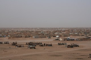
The Sahrawi refugee camps, also known as the Tindouf camps, are a collection of refugee camps set up in the Tindouf Province, Algeria in 1975–76 for Sahrawi refugees fleeing from Moroccan forces, who advanced through Western Sahara during the Western Sahara War. With most of the original refugees still living in the camps, the situation is among the most protracted in the world.
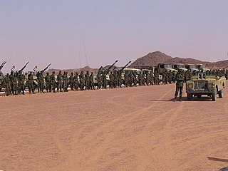
The Western Sahara War was an armed struggle between the Sahrawi indigenous Polisario Front and Morocco from 1975 to 1991, being the most significant phase of the Western Sahara conflict. The conflict erupted after the withdrawal of Spain from the Spanish Sahara in accordance with the Madrid Accords, by which it transferred administrative control of the territory to Morocco and Mauritania, but not sovereignty. In late 1975, the Moroccan government organized the Green March of some 350,000 Moroccan citizens, escorted by around 20,000 troops, who entered Western Sahara, trying to establish a Moroccan presence. While at first met with just minor resistance by the Polisario Front, Morocco later engaged a long period of guerrilla warfare with the Sahrawi nationalists. During the late 1970s, the Polisario Front, desiring to establish an independent state in the territory, attempted to fight both Mauritania and Morocco. In 1979, Mauritania withdrew from the conflict after signing a peace treaty with the Polisario Front. The war continued in low intensity throughout the 1980s, though Morocco made several attempts to take the upper hand in 1989–1991. A cease-fire agreement was finally reached between the Polisario Front and Morocco in September 1991. Some sources put the final death toll between 10,000 and 20,000 people.

The Schirmacher Oasis is a 25 km (16 mi) long and up to 3 km (1.9 mi) wide ice-free plateau with more than 100 freshwater lakes. It is situated in the Schirmacher Hills on the Princess Astrid Coast in Queen Maud Land in East Antarctica and is, on average, 100 m (330 ft) above sea level. With an area of 34 km2 (13 sq mi), the Schirmacher Oasis ranks among the smallest Antarctic oases and is a typical polar desert.

The 2011 Western Saharan protests began on 25 February 2011 as a reaction to the failure of police to prevent anti-Sahrawi looting in the city of Dakhla, Western Sahara, and blossomed into protests across the territory. They were related to the Gdeim Izik protest camp in Western Sahara established the previous fall, which had resulted in violence between Sahrawi activists and Moroccan security forces and supporters. The protests also purportedly drew inspiration from the Arab Spring and successful revolts in Tunisia and Egypt, although the Arab Spring proper did not reach Western Sahara.
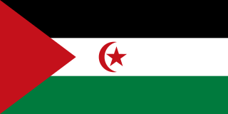
The Sahrawi Arab Democratic Republic, also known as the Sahrawi Republic and Western Sahara, is a partially recognized state, recognized by 46 UN member states and South Ossetia, located in the western Maghreb, which claims the non-self-governing territory of Western Sahara, but controls only the easternmost one-fifth of that territory. Between 1884 and 1975, Western Sahara was known as Spanish Sahara, a Spanish colony. The SADR is one of the two African states in which Spanish is a significant language, the other being Equatorial Guinea.
The Western Sahara peace process refers to the international efforts to resolve the Western Sahara conflict. The conflict has failed so far to result in permanent peace between Morocco and the Polisario Front. The standing issues of the peace process include Sahrawi refugees, and human rights in Western Sahara.
Sahrawi nationalism is a political ideology that seeks self-determination of the Sahrawi people, the indigenous population of Western Sahara. It has historically been represented by the Polisario Front. It came as a reaction against Spanish colonialist policies imposed from 1958 on, and subsequently in reaction to the Mauritanian and Moroccan invasions of 1975.
