Notes & references
Notes
Related Research Articles

The Canadian Shield, also called the Laurentian Shield or the Laurentian Plateau, is a geologic shield, a large area of exposed Precambrian igneous and high-grade metamorphic rocks. It forms the North American Craton, the ancient geologic core of the North American continent. Glaciation has left the area with only a thin layer of soil, through which exposures of igneous bedrock resulting from its long volcanic history are frequently visible. As a deep, common, joined bedrock region in eastern and central Canada, the shield stretches north from the Great Lakes to the Arctic Ocean, covering over half of Canada and most of Greenland; it also extends south into the northern reaches of the continental United States.
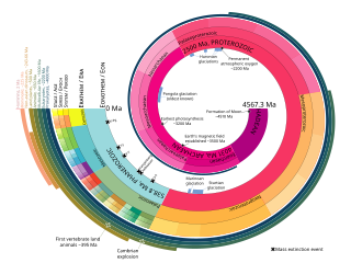
The geologic time scale or geological time scale (GTS) is a representation of time based on the rock record of Earth. It is a system of chronological dating that uses chronostratigraphy and geochronology. It is used primarily by Earth scientists to describe the timing and relationships of events in geologic history. The time scale has been developed through the study of rock layers and the observation of their relationships and identifying features such as lithologies, paleomagnetic properties, and fossils. The definition of standardised international units of geologic time is the responsibility of the International Commission on Stratigraphy (ICS), a constituent body of the International Union of Geological Sciences (IUGS), whose primary objective is to precisely define global chronostratigraphic units of the International Chronostratigraphic Chart (ICC) that are used to define divisions of geologic time. The chronostratigraphic divisions are in turn used to define geochronologic units.
The Precambrian is the earliest part of Earth's history, set before the current Phanerozoic Eon. The Precambrian is so named because it preceded the Cambrian, the first period of the Phanerozoic Eon, which is named after Cambria, the Latinised name for Wales, where rocks from this age were first studied. The Precambrian accounts for 88% of the Earth's geologic time.

The Archean Eon, in older sources sometimes called the Archaeozoic, is the second of the four geologic eons of Earth's history, preceded by the Hadean Eon and followed by the Proterozoic. The Archean represents the time period from 4,031 to 2,500 Ma. The Late Heavy Bombardment is hypothesized to overlap with the beginning of the Archean. The Huronian glaciation occurred at the end of the eon.

The Drakensberg is the eastern portion of the Great Escarpment, which encloses the central Southern African plateau. The Great Escarpment reaches its greatest elevation – 2,000 to 3,482 metres within the border region of South Africa and Lesotho.

The Mesoarchean is a geologic era in the Archean Eon, spanning 3,200 to 2,800 million years ago, which contains the first evidence of modern-style plate subduction and expansion of microbial life. The era is defined chronometrically and is not referenced to a specific level in a rock section on Earth.
The Huronian glaciation was a period where at least three ice ages occurred during the deposition of Huronian Supergroup. Deposition of this largely sedimentary succession extended from approximately 2.5 to 2.2 billion years ago (Gya), during the Siderian and Rhyacian periods of the Paleoproterozoic era. Evidence for glaciation is mainly based on the recognition of diamictite, that is interpreted to be of glacial origin. Deposition of the Huronian succession is interpreted to have occurred within a rift basin that evolved into a largely marine passive margin setting. The glacial diamictite deposits within the Huronian are on par in thickness with Quaternary analogs.
The Andean-Saharan glaciation, also known as the Early Paleozoic Ice Age (EPIA), the Early Paleozoic Icehouse, the Late Ordovician glaciation, the end-Ordovician glaciation, or the Hirnantian glaciation, occurred during the Paleozoic from approximately 460 Ma to around 420 Ma, during the Late Ordovician and the Silurian period. The major glaciation during this period was formerly thought only to consist of the Hirnantian glaciation itself but has now been recognized as a longer, more gradual event, which began as early as the Darriwilian, and possibly even the Floian. Evidence of this glaciation can be seen in places such as Arabia, North Africa, South Africa, Brazil, Peru, Bolivia, Chile, Argentina, and Wyoming. More evidence derived from isotopic data is that during the Late Ordovician, tropical ocean temperatures were about 5 °C cooler than present day; this would have been a major factor that aided in the glaciation process.

The Acasta Gneiss Complex, also called the Acasta Gneiss, is a body of felsic to ultramafic Archean basement rocks, gneisses, that form the northwestern edge of the Slave Craton in the Northwest Territories, Canada, about 300 km (190 mi) north of Yellowknife, Canada. This geologic complex consists largely of tonalitic and granodioritic gneisses and lesser amounts of mafic and ultramafic gneisses. It underlies and is largely concealed by thin, patchy cover of Quaternary glacial sediments over an area of about 13,000 km2 (5,000 sq mi). The Acasta Gneiss Complex contains fragments of the oldest known crust and record of more than a billion years of magmatism and metamorphism. The Acasta Gneiss Complex is exposed in a set of anticlinoriums within the foreland fold and thrust belt of the Paleoproterozoic Wopmay Orogen.

Jasper conglomerate is an informal term for a very distinctive Paleoproterozoic quartz and jasper pebble conglomerate that occurs within the middle part of the Lorrain Formation of the Cobalt Group of the Huronian Supergroup. It is also known by other names including pebble jasper conglomerate, St. Joseph Island puddingstone, Drummond Island puddingstone, Michigan puddingstone. The jasper conglomerate occurs on St. Joseph Island and the St. Mary's River area north and northwest of the Bruce Mines of Northern Ontario, about 65 kilometres (40 mi) east of Sault Ste. Marie. This conglomerate consisted originally of gravelly sands and sandy gravels composed of subrounded pebbles of red jasper, white quartzite, semi-transparent quartz, and black chert, with coarse-grained sand matrix. Typically it contains between about 30% to as much as 90% pebbles. It has been cemented and partially metamorphosed into a quartzitic conglomerate. The beds of jasper conglomerates fill erosional troughs and channels of what are interpreted to be either alluvial fan or braided river deposits of the Lorrain Formation. These deposits are interpreted to represent nonglacial deposits that immediately postdate the Makganyene glaciation.

The Great Oxidation Event (GOE) or Great Oxygenation Event, also called the Oxygen Catastrophe, Oxygen Revolution, Oxygen Crisis or Oxygen Holocaust, was a time interval during the Early Earth's Paleoproterozoic era when the Earth's atmosphere and the shallow ocean first experienced a rise in the concentration of oxygen. This began approximately 2.460–2.426 Ga (billion years) ago during the Siderian period and ended approximately 2.060 Ga ago during the Rhyacian. Geological, isotopic, and chemical evidence suggests that biologically produced molecular oxygen (dioxygen or O2) started to accumulate in Earth's atmosphere and changed it from a weakly reducing atmosphere practically devoid of oxygen into an oxidizing one containing abundant free oxygen, with oxygen levels being as high as 10% of their present atmospheric level by the end of the GOE.

The oldest dated rocks formed on Earth, as an aggregate of minerals that have not been subsequently broken down by erosion or melted, are more than 4 billion years old, formed during the Hadean Eon of Earth's geological history, and mark the start of the Archean Eon, which is defined to start with the formation of the oldest intact rocks on Earth. Meteorites that were formed in other planetary systems can pre-date Earth. Particles from the Murchison meteorite were dated in January 2020 to be 7 billion years old.

The Karoo Supergroup is the most widespread stratigraphic unit in Africa south of the Kalahari Desert. The supergroup consists of a sequence of units, mostly of nonmarine origin, deposited between the Late Carboniferous and Early Jurassic, a period of about 120 million years.

The Cape Fold Belt is a fold and thrust belt of late Paleozoic age, which affected the sequence of sedimentary rock layers of the Cape Supergroup in the southwestern corner of South Africa. It was originally continuous with the Ventana Mountains near Bahía Blanca in Argentina, the Pensacola Mountains, the Ellsworth Mountains and the Hunter-Bowen orogeny in eastern Australia. The rocks involved are generally sandstones and shales, with the shales persisting in the valley floors while the erosion resistant sandstones form the parallel ranges, the Cape Fold Mountains, which reach a maximum height of 2325 m at Seweweekspoortpiek.
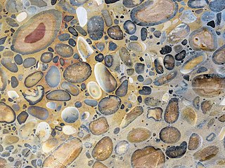
Puddingstone, also known as either pudding stone or plum-pudding stone, is a popular name applied to a conglomerate that consists of distinctly rounded pebbles whose colours contrast sharply with the colour of the finer-grained, often sandy, matrix or cement surrounding them. The rounded pebbles and the sharp contrast in colour gives this type of conglomerate the appearance of a raisin or Christmas pudding. There are different types of puddingstone, with different composition, origin, and geographical distribution. Examples of different types of puddingstones include the Hertfordshire, Schunemunk, Roxbury, and St. Joseph Island puddingstones.

Table Mountain Sandstone (TMS) is a group of rock formations within the Cape Supergroup sequence of rocks. Although the term "Table Mountain Sandstone" is still widely used in common parlance, the term TMS is no longer formally recognized; the correct name is the "Peninsula Formation Sandstone", which is part of the Table Mountain Group. The designation "Table Mountain Sandstone" will, however, in deference to the title, continue to be used in the rest of this article. The name is derived from the famous landmark in Cape Town, Table Mountain.
Abderrazak El Albani is a French-Moroccan sedimentologist, professor at University of Poitiers at the Hydrasa laboratory. He is known for describing the "Francevillian Biota" from the Paleoproterozoic of Gabon, which he suggests represents the oldest known multicellular organisms, though this claim has been questioned by other authors.

The Dwyka Group is one of four geological groups that compose the Karoo Supergroup. It is the lowermost geological group and heralds the commencement of sedimentation of the Karoo Supergroup. Based on stratigraphic position, lithostratigraphic correlation and palynological analyses, these lowermost Karoo strata range between the Late Carboniferous (Pennsylvanian) to Early Permian in age.

The Lufilian Arc is part of a system of orogenic belts in southern Africa formed during the Pan-African orogeny, a stage in the formation of the Gondwana supercontinent. It extends across eastern Angola, the Katanga Province of the southern Democratic Republic of the Congo and the northwest of Zambia. The arc is about 800 kilometres (500 mi) long. It has global economic importance owing to its rich deposits of copper and cobalt.
The geology of Mozambique is primarily extremely old Precambrian metamorphic and igneous crystalline basement rock, formed in the Archean and Proterozoic, in some cases more than two billion years ago. Mozambique contains greenstone belts and spans the Zimbabwe Craton, a section of ancient stable crust. The region was impacted by major tectonic events, such as the mountain building Irumide orogeny, Pan-African orogeny and the Snowball Earth glaciation. Large basins that formed in the last half-billion years have filled with extensive continental and marine sedimentary rocks, including rocks of the extensive Karoo Supergroup which exist across Southern Africa. In some cases these units are capped by volcanic rocks. As a result of its complex and ancient geology, Mozambique has deposits of iron, coal, gold, mineral sands, bauxite, copper and other natural resources.
References
- 1 2 Kopp et al. 2005.
- ↑ USGS 2008, p. 86.
- ↑ University of KwaZulu-Natal.
- ↑ Kasting & Howard 2006.
- ↑ Kasting & Ono 2006.
- ↑ Young et al. 1998.
- ↑ Zalasiewicz & Williams 2012, p. 30.
- 1 2 3 USGS 2008, pp. 86–87.
- ↑ Deconinck.
- ↑ El Albani, Macchiarelli & Meunier 2016, p. 15.
- ↑ USGS 2008, p. 87.
- ↑ Zalasiewicz & Williams 2012, p. 23.
- ↑ Zalasiewicz & Williams 2012, p. 16.