Pool of London

Last updated

A view of the Pool of London, River Thames, around 1938 The Pool of London.jpg
A view of the Pool of London, River Thames, around 1938
A 1905 Thames wharf map from London Bridge to Limehouse showing the Pool of London Thames wharf map 1905 London Bridge to Limehouse.jpg
A 1905 Thames wharf map from London Bridge to Limehouse showing the Pool of London

The Pool of London is a stretch of the River Thames from London Bridge to below Limehouse.

Contents

Part of the Tideway of the Thames, the Pool was navigable by tall-masted vessels bringing coastal and later overseas goods—the wharves there were the original part of the Port of London. The Pool of London is divided into two parts, the Upper Pool and Lower Pool. The Upper Pool consists of the section between London Bridge, which blocked tall-masts from continuing west, and the Cherry Garden Pier in Bermondsey. The Lower Pool runs from the Cherry Garden Pier to Limekiln Creek. [1]

History

Originally, the Pool of London was the stretch of the River Thames along Billingsgate on the south side of the City of London where all imported cargoes had to be delivered for inspection and assessment by Customs Officers, giving the area the name of "Legal Quays". [2] Smuggling, theft and pilferage of cargoes were rife, both on the busy open wharves and in the crowded warehouses. The term was later used more generally to refer to the stretch of the river from Rotherhithe upriver to London Bridge, with the venerable bridge being the farthest reach that could be navigated by a tall-masted vessel.

Legal Quays in 1757, by Louis Peter Boitard. Imports from France Boitard 1757.jpg
Legal Quays in 1757, by Louis Peter Boitard.
A view of the Pool of London, River Thames, 1841 Pool of London, River Thames, 1841.jpg
A view of the Pool of London, River Thames, 1841

The Pool of London was of vital importance to the capital for centuries - as early as the 7th century Bede wrote that it was the reason for London's existence [ citation needed ] - but it reached its peak in the 18th and 19th centuries. By this time the river was lined with nearly-continuous walls of wharves running for miles along both banks, and hundreds of ships moored in the river or alongside the quays. [3]

The Pool of London saw a phenomenal increase in both overseas and coastal trade in the second half of the eighteenth century. Two-thirds of coastal vessels using it were colliers meeting an increase in the demand for coal as the population of London rose. Coastal trade virtually doubled between 1750 and 1796 reaching 11,964 vessels in 1795. In overseas trade, in 1751 the Pool of London handled 1,682 ships and 234,639 tons of goods but by 1794 this had risen to 3,663 ships and 620,845 tons. [4]

The congestion was so extreme that it was said to be possible to walk across the Thames simply by stepping from ship to ship.[ citation needed ] London's Docklands had their origins in the lack of capacity in the Pool of London which particularly affected the West India trade. The West India Dock Act 1799 allowed a new off-river dock to be built for produce from the West Indies [2] and the rest of Docklands followed as landowners built enclosed docks with better security and facilities than the Pool's wharves.

Even after the construction of off-river docks, the Pool of London remained an important part of the Port of London. Shipping needed unrestricted access to the Pool of London which imposed constraints on the crossings that became increasingly necessary with the commercial development on both sides of the river. The Thames Tunnel from Rotherhithe to Wapping was constructed between 1825 and 1843. Tower Bridge opened in 1894 as a bascule bridge. In 1909 the Pool came under the jurisdiction of the Port of London Authority. The docks thrived up until the 1950s, despite suffering extremely severe bomb damage during the Second World War.

A ship unloading in 1962 Upper Pool 1.jpg
A ship unloading in 1962

The abrupt collapse of commercial traffic in the Thames due to the introduction of shipping containers and coastal deep-water ports in the 1960s emptied the Pool and led to all of the wharves being closed down, and many being demolished. The area was extensively redeveloped in the 1980s and 1990s to create new residential and commercial neighbourhoods. [5]

Urban renewal

In 1996, an organisation - the Pool of London Partnership - was established to help promote urban renewal of the areas north and south of the river. It also extended its remit slightly further eastwards to include the docks and wharves of St Katharine Docks and Shad Thames. After a decade of regeneration and an investment of approximately £100m, the Pool of London Partnership was due to dissolve in March 2007 with its work to be partially continued by three new organisations: Team London Bridge, the Potters Fields Park Management Trust and the Tower Hill Management Group.

The 'core area' includes Borough Market, London Bridge, Guy's Hospital, London Bridge station, Hay's Galleria, HMS Belfast, City Hall, Shad Thames, Tower Bridge, St Katharine Docks, the Tower of London, Tower Hill Underground station and the Monument to the Great Fire of London.

Cultural references

André Derain painted four works of the Thames, and his The Pool of London painted in 1906 is on display at the Tate Gallery. Derain was a leading Fauvist and had been sent to London by his dealer to produce Thames views in the Fauvist style. [6]

A British film, Pool of London (1951), is a crime drama set within the Pool. The film was directed by Basil Dearden, and features actors Earl Cameron, Susan Shaw, Joan Dowling, and Bonar Colleano, and comic actors Leslie Phillips, Alfie Bass and James Robertson Justice. [7] The Pool has also featured as a location in various other films.[ example needed ]

Patrick O'Brian refers to the Pool of London in his novels The Commodore and Blue at the Mizzen , both in the Aubrey-Maturin series.

See also

Related Research Articles

<span class="mw-page-title-main">London Docklands</span> Area in east and southeast London, UK

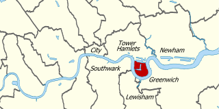
London Docklands is the riverfront and former docks in London. It is located in inner east and southeast London, in the boroughs of Southwark, Tower Hamlets, Lewisham, Newham, and Greenwich. The docks were formerly part of the Port of London, at one time the world's largest port. After the docks closed, the area had become derelict and poverty-ridden by the 1980s. The Docklands' regeneration began later that decade; it has been redeveloped principally for commercial and residential use. The name "London Docklands" was used for the first time in a government report on redevelopment plans in 1971 and has since been almost universally adopted. The redevelopment created wealth, but also led to some conflict between the new and old communities in the area.

<span class="mw-page-title-main">Bermondsey</span> District in the London Borough of Southwark

Bermondsey is a district in southeast London, part of the London Borough of Southwark, England, 2.5 miles (4.0 km) southeast of Charing Cross. To the west of Bermondsey lies Southwark, to the east Rotherhithe and Deptford, to the south Walworth and Peckham, and to the north is Wapping across the River Thames. It lies within the historic county boundaries of Surrey. During the Industrial Revolution Bermondsey became a centre for manufacturing, particularly in relation to tanning. More recently it has experienced regeneration including warehouse conversions to flats and the provision of new transport links.

<span class="mw-page-title-main">Isle of Dogs</span> Area in the East End of London, England

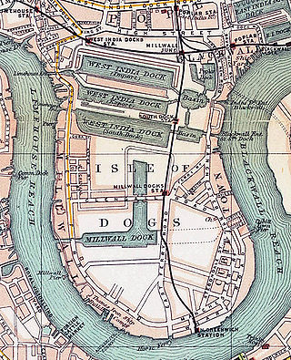
The Isle of Dogs is a large peninsula bounded on three sides by a large meander in the River Thames in East London, England, which includes the Cubitt Town, Millwall and Canary Wharf districts. The area was historically part of the Manor, Hamlet, Parish and, for a time, the wider borough of Poplar. The name had no official status until the 1987 creation of the Isle of Dogs Neighbourhood by Tower Hamlets London Borough Council. It has been known locally as simply "the Island" since the 19th century.

<span class="mw-page-title-main">Limehouse</span> District in Tower Hamlets, London

Limehouse is a district in the London Borough of Tower Hamlets in East London. It is 3.9 miles (6.3 km) east of Charing Cross, on the northern bank of the River Thames. Its proximity to the river has given it a strong maritime character, which it retains through its riverside public houses and steps, such as The Grapes and Limehouse Stairs. It is part of the traditional county of Middlesex. It became part of the ceremonial County of London following the passing of the Local Government Act 1888, and then part of Greater London in 1965. It is located between Stepney to the west and north, Mile End and Bow to the northwest, Poplar to the east, and Canary Wharf and Millwall to the south, and stretches from the end of Cable Street and Butcher Row in the west to Stainsby Road near Bartlett Park in the east, and from West India Dock and the River Thames in the south to Salmon Lane and Rhodeswell Road in the north.

<span class="mw-page-title-main">Rotherhithe</span> Residential district in southeast London, England

Rotherhithe is a district of south-east London, England, and part of the London Borough of Southwark. It is on a peninsula on the south bank of the Thames, facing Wapping, Shadwell and Limehouse on the north bank, as well as the Isle of Dogs to the east of the Thames and is a part of the Docklands area. It borders Bermondsey to the west and Deptford to the south east.

The Port of London is that part of the River Thames in England lying between Teddington Lock and the defined boundary with the North Sea and including any associated docks. Once the largest port in the world, it was the United Kingdom's largest port as of 2020. Usage is largely governed by the Port of London Authority ("PLA"), a public trust established in 1908; while mainly responsible for coordination and enforcement of activities it also has some minor operations of its own.

<span class="mw-page-title-main">West India Docks</span> Historic dock site, now part of Canary Wharf area.

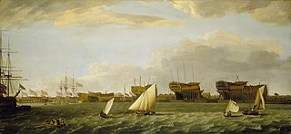
The West India Docks are a series of three docks, quaysides and warehouses built to import goods from and export goods and occasionally passengers to the British West Indies on the Isle of Dogs in London the first of which opened in 1802. Following their commercial closure in 1980, the Canary Wharf development was built around the wet docks by narrowing some of their broadest tracts.

<span class="mw-page-title-main">Blackwall, London</span> Area of the East End of London, England

Blackwall is an area of Poplar, in the London Borough of Tower Hamlets, East London. The neighbourhood includes Leamouth and the Coldharbour conservation area.

<span class="mw-page-title-main">London Docklands Development Corporation</span> English regeneration agency (1981–1998)

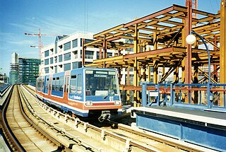
The London Docklands Development Corporation (LDDC) was a quango agency set up by the UK Government in 1981 to regenerate the depressed Docklands area of east London. During its seventeen-year existence it was responsible for regenerating an area of 8.5 square miles (22 km2) in the London Boroughs of Newham, Tower Hamlets and Southwark. LDDC helped to create Canary Wharf, Surrey Quays shopping centre, London City Airport, ExCeL Exhibition Centre, London Arena and the Docklands Light Railway, bringing more than 120,000 new jobs to the Docklands and making the area highly sought after for housing. Although initially fiercely resisted by local councils and residents, today it is generally regarded as having been a success and is now used as an exemplar of large-scale regeneration, although tensions between older and more recent residents remain.

<span class="mw-page-title-main">London Docks</span>

The London Docks were one of several sets of docks in the historic Port of London.

<span class="mw-page-title-main">Greenland Dock</span> Dock in Rotherhithe, London

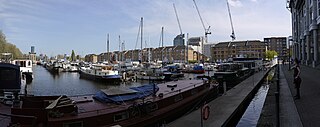
Greenland Dock is the oldest of London's riverside wet docks, located in Rotherhithe in the area of the city now known as Docklands. It used to be part of the Surrey Commercial Docks, most of which have by now been filled in. Greenland Dock is now used purely for recreational purposes; it is one of only two functioning enclosed docks on the south bank of the River Thames, along with the smaller South Dock, to which it is connected by a channel now known as Greenland Cut.

<span class="mw-page-title-main">East London</span> Northeastern part of London, United Kingdom

East London is the northeastern part of London, United Kingdom. Located east of the ancient City of London and north of the River Thames as it begins to widen, East London developed as London's docklands and the primary industrial centre. The expansion of railways in the 19th century encouraged the eastward expansion of the East End of London and a proliferation of new suburbs. The industrial lands of East London are today an area of regeneration, which are well advanced in places such as Canary Wharf and ongoing elsewhere.

<span class="mw-page-title-main">Shad Thames</span> Area of Bermondsey in London, England

Shad Thames is a historic riverside street next to Tower Bridge in Bermondsey, London, England, and is also an informal name for the surrounding area. In the 19th century, the area included the largest warehouse complex in London.

<span class="mw-page-title-main">Tideway</span> The part of the River Thames subject to tides

The Tideway is a part of the River Thames in England which is subject to tides. This stretch of water is downstream from Teddington Lock. The Tideway comprises the upper Thames Estuary including the Pool of London.

<span class="mw-page-title-main">St Saviour's Dock</span>

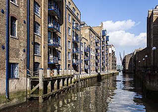
St Saviour's Dock is an inlet-style dock in London, England, on the south bank of the River Thames, 420 metres east of Tower Bridge. It forms the eastern end of the Shad Thames embankment that starts at Tower Bridge. The east side of the Dock is Jacob's Island.

<span class="mw-page-title-main">1928 Thames flood</span> Combined storm surge and river flood of the River Thames

The 1928 Thames flood was a disastrous flood of the River Thames that affected much of riverside London on 7 January 1928, as well as places further downriver. Fourteen people died and thousands were made homeless when floodwaters poured over the top of the Thames Embankment and part of the Chelsea Embankment collapsed. It was the last major flood to affect central London, and, along with the disastrous North Sea flood of 1953, helped lead to the implementation of new flood control measures that culminated in the construction of the Thames Barrier in the 1970s.

<span class="mw-page-title-main">Blackwall Yard</span> Former shipyard in Blackwall, London

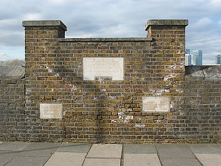
Blackwall Yard is a small body of water that used to be a shipyard on the River Thames in Blackwall, engaged in ship building and later ship repairs for over 350 years. The yard closed in 1987.

<span class="mw-page-title-main">Coldharbour, Tower Hamlets</span>

Coldharbour is a street and wider conservation area in Blackwall, lying on the north bank of the River Thames, east of Canary Wharf. The area is said to be "[t]he sole remaining fragment of the old hamlet of Blackwall" and "one of the last examples of the narrow streets which once characterised the river's perimeter".

<span class="mw-page-title-main">Legal Quays</span>

The Legal Quays of England were created by the Act of Frauds, an Act of Parliament enacted in 1559 during the reign of Elizabeth I of England. It established new rules for customs in England in order to boost the Crown's finances. One of its most important provisions was the establishment of a rule that it was illegal to land or load goods anywhere other than authorised Legal Quays in London and other ports, under the supervision of customs officers. The legislation also set out which towns were authorised to act as ports.

References

  1. Weinreb, Ben; Hibbert, Christopher (1983). The London Encyclopaedia. London: Macmillan. p. 610. ISBN   0-333-30024-6.
  2. 1 2 Museum of London Docklands Archived 30 January 2010 at the Wayback Machine
  3. "The West India Docks: Introduction, Survey of London: volumes 43 and 44: Poplar, Blackwall and Isle of Dogs (1994), pp. 247-248. Date accessed: 16 April 2010". British-history.ac.uk. 22 June 2003. Retrieved 13 June 2012.
  4. "The West India Docks: Introduction, Survey of London: volumes 43 and 44: Poplar, Blackwall and Isle of Dogs (1994), pp. 247-248. Date accessed: 16 April 2010". British-history.ac.uk. 22 June 2003. Retrieved 13 June 2012.
  5. "LDDC Completion Booklets - Bermondsey Riverside". Lddc-history.org.uk. Retrieved 13 June 2012.
  6. "Tate Gallery Andre Derain - The Pool of London". Tate.org.uk. Retrieved 13 June 2012.
  7. Pool of London at IMDb

Coordinates: 51°30′23″N0°04′40″W / 51.5063°N 0.0778°W / 51.5063; -0.0778