Related Research Articles

Satellite temperature measurements are inferences of the temperature of the atmosphere at various altitudes as well as sea and land surface temperatures obtained from radiometric measurements by satellites. These measurements can be used to locate weather fronts, monitor the El Niño-Southern Oscillation, determine the strength of tropical cyclones, study urban heat islands and monitor the global climate. Wildfires, volcanos, and industrial hot spots can also be found via thermal imaging from weather satellites.
Water vapor, water vapour or aqueous vapor is the gaseous phase of water. It is one state of water within the hydrosphere. Water vapor can be produced from the evaporation or boiling of liquid water or from the sublimation of ice. Water vapor is transparent, like most constituents of the atmosphere. Under typical atmospheric conditions, water vapor is continuously generated by evaporation and removed by condensation. It is less dense than most of the other constituents of air and triggers convection currents that can lead to clouds and fog.

A microwave radiometer (MWR) is a radiometer that measures energy emitted at one millimeter-to-metre wavelengths (frequencies of 0.3–300 GHz) known as microwaves. Microwave radiometers are very sensitive receivers designed to measure thermally-emitted electromagnetic radiation. They are usually equipped with multiple receiving channels to derive the characteristic emission spectrum of planetary atmospheres, surfaces or extraterrestrial objects. Microwave radiometers are utilized in a variety of environmental and engineering applications, including remote sensing, weather forecasting, climate monitoring, radio astronomy and radio propagation studies.

The Schumann resonances (SR) are a set of spectrum peaks in the extremely low frequency (ELF) portion of the Earth's electromagnetic field spectrum. Schumann resonances are global electromagnetic resonances, generated and excited by lightning discharges in the cavity formed by the Earth's surface and the ionosphere.

The solar constant (GSC) is a flux density measuring mean solar electromagnetic radiation per unit area. It is measured on a surface perpendicular to the rays, one astronomical unit (au) from the Sun.

The Journal of Geophysical Research is a peer-reviewed scientific journal. It is the flagship journal of the American Geophysical Union. It contains original research on the physical, chemical, and biological processes that contribute to the understanding of the Earth, Sun, and Solar System. It has seven sections: A, B, C (Oceans), D (Atmospheres), E (Planets), F, and G (Biogeosciences). All current and back issues are available online for subscribers.

The atmosphere of Mars is the layer of gases surrounding Mars. It is primarily composed of carbon dioxide (95%), molecular nitrogen (2.8%), and argon (2%). It also contains trace levels of water vapor, oxygen, carbon monoxide, hydrogen, and noble gases. The atmosphere of Mars is much thinner than Earth's. The average surface pressure is only about 610 pascals (0.088 psi) which is less than 1% of the Earth's value. The currently thin Martian atmosphere prohibits the existence of liquid water on the surface of Mars, but many studies suggest that the Martian atmosphere was much thicker in the past. The higher density during spring and fall is reduced by 25% during the winter when carbon dioxide partly freezes at the pole caps. The highest atmospheric density on Mars is equal to the density found 35 km (22 mi) above the Earth's surface and is ≈0.020 kg/m3. The atmosphere of Mars has been losing mass to space since the planet's core slowed down, and the leakage of gases still continues today.
The oceanic or limnological mixed layer is a layer in which active turbulence has homogenized some range of depths. The surface mixed layer is a layer where this turbulence is generated by winds, surface heat fluxes, or processes such as evaporation or sea ice formation which result in an increase in salinity. The atmospheric mixed layer is a zone having nearly constant potential temperature and specific humidity with height. The depth of the atmospheric mixed layer is known as the mixing height. Turbulence typically plays a role in the formation of fluid mixed layers.
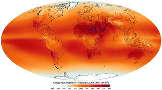
Outgoing Long-wave Radiation (OLR) is electromagnetic radiation of wavelengths from 3–100 μm emitted from Earth and its atmosphere out to space in the form of thermal radiation. It is also referred to as up-welling long-wave radiation and terrestrial long-wave flux, among others. The flux of energy transported by outgoing long-wave radiation is measured in W/m2 or W⋅m−2. Infrared radiation of Earth is 239 W⋅m−2, one of two outgoing energy values of Earth's energy budget, the other being the reflected energy of 102 W⋅m−2, and effectively being the 255 K calculated blackbody temperature of Earth. In the Earth's climate system, long-wave radiation involves processes of absorption, scattering, and emissions from atmospheric gases, aerosols, clouds and the surface.

The climate of Mars has been a topic of scientific curiosity for centuries, in part because it is the only terrestrial planet whose surface can be directly observed in detail from the Earth with help from a telescope.

Radio occultation (RO) is a remote sensing technique used for measuring the physical properties of a planetary atmosphere or ring system. Other satellite carriers onboard GNSS-Radio occultation include CHAMP (satellite), GRACE and GRACE-FO, MetOp and the recently launched COSMIC-2.

A drifter is an oceanographic device floating on the surface to investigate ocean currents by tracking location. They can also measure other parameters like sea surface temperature, salinity, barometric pressure, and wave height. Modern drifters are typically tracked by satellite, often GPS. They are sometimes called Lagrangian drifters since the location of the measurements they make moves with the flow. A major user of drifters is NOAA's Global Drifter Program.
The marine optical buoy (MOBY) measures light at and very near the sea surface in a specific location over a long period of time, serving as part of an ocean color observation system. Satellites are another component of the system, providing global coverage through remote sensing; however, satellites measure light above the Earth's atmosphere, becoming subject to interference from the atmosphere itself and other light sources. The Marine Optical Buoy helps alleviate that interference and thus improve the quality of the overall ocean color observation system.
UNAVCO is a non-profit university-governed consortium that facilitates geology research and education using Geodesy. UNAVCO is funded by the National Science Foundation (NSF) and the National Aeronautics and Space Administration (NASA) to support geology research worldwide. UNAVCO operates the GAGE Facility on behalf of the NSF and NASA. As a university-governed consortium, UNAVCO supports the goals of the academic scientific community. UNAVCO has 120 US academic members and supports over 110 organizations globally as associate members.

Frost flowers are ice crystals commonly found growing on young sea ice and thin lake ice in cold, calm conditions. The ice crystals are similar to hoar frost, and are commonly seen to grow in patches around 3–4 cm in diameter. Frost flowers growing on sea ice have extremely high salinities and concentrations of other sea water chemicals and, because of their high surface area, are efficient releasers of these chemicals into the atmosphere.
Richard M. "Dick" Goldstein is an American radar astronomer and planetary scientist, who has been called "The Father of Radar Interferometry."
Space-based measurements of carbon dioxide are used to help answer questions about Earth's carbon cycle. There are a variety of active and planned instruments for measuring carbon dioxide in Earth's atmosphere from space. The first satellite mission designed to measure CO2 was the Interferometric Monitor for Greenhouse Gases (IMG) on board the ADEOS I satellite in 1996. This mission lasted less than a year. Since then, additional space-based measurements have begun, including those from two high-precision satellites. Different instrument designs may reflect different primary missions.
Jennifer Logan is an atmospheric scientist known for her research on how human activities influence the atmosphere, particularly with respect to biomass burning and the ozone hole.
The sea surface skin temperature (SSTskin), or ocean skin temperature, is the temperature of the sea surface as determined through its infrared spectrum (3.7-12μm) and represents the temperature of the sublayer of water at a depth of 10-20 μm. High-resolution data of skin temperature gained by satellites in passive infrared measurements is a crucial constituent in determining the sea surface temperature (SST). Since the skin layer is in radiative equilibrium with the atmosphere and the sun, its temperature underlies a daily cycle. Even small changes in the skin temperature can lead to large changes in atmospheric circulation. This makes skin temperature a widely used quantity in weather forecasting and climate science.
Atmospheric correction for Interferometric Synthetic ApertureRadar (InSAR) technique is a set of different methods to remove artefact displacement from an interferogram caused by the effect of weather variables such as humidity, temperature, and pressure. An interferogram is generated by processing two synthetic-aperture radar images before and after a geophysical event like an earthquake. Corrections for atmospheric variations are an important stage of InSAR data processing in many study areas to measure surface displacement because relative humidity differences of 20% can cause inaccuracies of 10–14 cm InSAR due to varying delays in the radar signal. Overall, atmospheric correction methods can be divided into two categories: a) Using Atmospheric Phase Screen (APS) statistical properties and b) Using auxiliary (external) data such as GPS measurements, multi-spectral observations, local meteorological models, and global atmospheric models.
References
- ↑ Bevis, M.; et al. (1992). "GPS Meteorology: Remote Sensing of Atmospheric Water Vapor Using the Global Positioning System". Journal of Geophysical Research. 97 (D14): 15787–15801. Bibcode:1992JGR....9715787B. doi:10.1029/92JD01517.
- ↑ Liu, Timothy (27 February 1986). "Statistical Relation between Mean Precipitable Water and Surface-Level Humidity over Global Oceans". Monthly Weather Review. 114 (8): 1591–1602. Bibcode:1986MWRv..114.1591L. doi: 10.1175/1520-0493(1986)114<1591:srbmmp>2.0.co;2 .
- ↑ Hsu, S.A.; Blanchard, B.W. (15 October 1989). "The Relationship Between Total Precipitable Water and Surface-Level Humidity Over the Sea Surface: A Further Evaluation". Journal of Geophysical Research. 94 (C10): 14539–14545. Bibcode:1989JGR....9414539H. doi:10.1029/JC094iC10p14539.
- ↑ Guangxiong, Peng; Jing, Li; Yunhao, Chen; Norizan, Abdul; Tay, Liphong (17 July 2006). "High-resolution Surface Relative Humidity Computation Using MODIS Image in Peninsular Malaysia" (PDF). Chinese Geographical Science. 16 (3): 260–264. doi:10.1007/s11769-006-0260-6. S2CID 73558154 . Retrieved 22 January 2014.