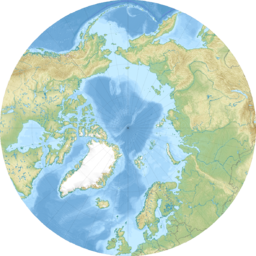
The Arctic Archipelago, also known as the Canadian Arctic Archipelago, is an archipelago lying to the north of the Canadian continental mainland, excluding Greenland and Iceland.

Fram ("Forward") is a ship that was used in expeditions of the Arctic and Antarctic regions by the Norwegian explorers Fridtjof Nansen, Otto Sverdrup, Oscar Wisting, and Roald Amundsen between 1893 and 1912. It was designed and built by the Scottish-Norwegian shipwright Colin Archer for Fridtjof Nansen's 1893 Arctic expedition in which the plan was to freeze Fram into the Arctic ice sheet and float with it over the North Pole.

The Queen Elizabeth Islands are the northernmost cluster of islands in Canada's Arctic Archipelago, split between Nunavut and the Northwest Territories in Northern Canada. The Queen Elizabeth Islands contain approximately 14% of the global glacier and ice cap area. The southern islands are called the Parry Islands or Parry Archipelago.
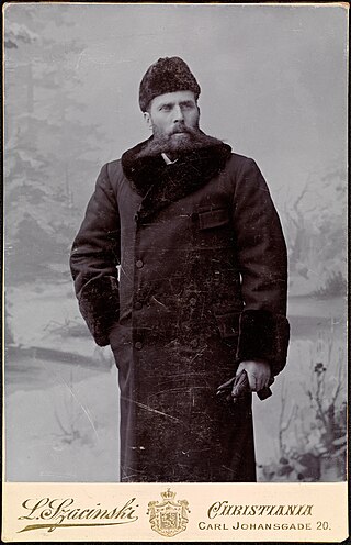
Otto Neumann Knoph Sverdrup was a Norwegian sailor and Arctic explorer.

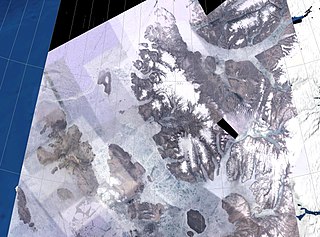
Axel Heiberg Island is an uninhabited island in the Qikiqtaaluk Region, Nunavut, Canada. Located in the Arctic Ocean, it is the 32nd largest island in the world and Canada's seventh largest island. According to Statistics Canada, it has an area of 43,178 km2 (16,671 sq mi). It is named after Axel Heiberg.
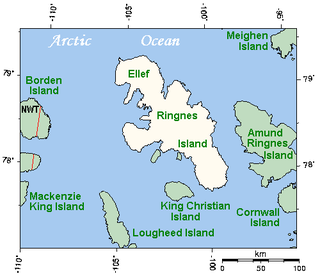
Ellef Ringnes Island is an uninhabited island and one of the Sverdrup Islands in the Qikiqtaaluk Region, Nunavut, Canada. A member of the Queen Elizabeth Islands and Arctic Archipelago, it is located in the Arctic Ocean, east of Borden Island, and west of Amund Ringnes Island. It has an area of 11,295 km2 (4,361 sq mi), making it the 69th largest island in the world and Canada's 16th largest island. Its highest mount is 260 m (850 ft).
The Sverdrup Islands is an archipelago of the northern Queen Elizabeth Islands, in Nunavut, Canada. The islands are situated in the Arctic Ocean, west of Ellesmere Island from 77° to 81° North and 85° to 106° West.

Amund Ringnes Island is an uninhabited island and one of the Sverdrup Islands and Queen Elizabeth Islands in the Qikiqtaaluk Region, Nunavut, Canada. It is located in the Arctic Ocean, between 78 and 79 degrees of latitude. It lies east of Ellef Ringnes Island, west of Axel Heiberg Island. Hassel Sound separates Amund Ringnes Island from Ellef Ringnes Island. Hendriksen Strait is to the south, as is Cornwall Island. Norwegian Bay is to the east, as is Haig-Thomas Island. To the north lies Peary Channel.

Lincoln Sea is a body of water in the Arctic Ocean, stretching from Cape Columbia, Canada, in the west to Cape Morris Jesup, Greenland, in the east. The northern limit is defined as the great circle line between those two headlands. It is covered with sea ice throughout the year, the thickest sea ice in the Arctic Ocean, which can be up to 15 m (49 ft) thick. Water depths range from 100 m (330 ft) to 300 m (980 ft). Water and ice from Lincoln Sea empty into Robeson Channel, the northernmost part of Nares Strait, most of the time.

Viscount Melville Sound, formerly Melville Sound, is an arm of the Arctic Ocean in the Kitikmeot Region, Nunavut and the Inuvik Region, Northwest Territories, Canada. Forming part of the Parry Channel, it separates Victoria Island and Prince of Wales Island from the Queen Elizabeth Islands. East of the sound, via Barrow Strait, lies Lancaster Sound, leading into Baffin Bay; westward lies the M'Clure Strait and the Arctic Ocean / Beaufort Sea. The sound is a part of the Northwest Passage.

The Arctic Cordillera is a terrestrial ecozone in northern Canada characterized by a vast, deeply dissected chain of mountain ranges extending along the northeastern flank of the Canadian Arctic Archipelago from Ellesmere Island to the northeasternmost part of the Labrador Peninsula in northern Labrador and northern Quebec, Canada. It spans most of the eastern coast of Nunavut with high glaciated peaks rising through ice fields and some of Canada's largest ice caps, including the Penny Ice Cap on Baffin Island. It is bounded to the east by Baffin Bay, Davis Strait and the Labrador Sea while its northern portion is bounded by the Arctic Ocean.
King Christian Island is an uninhabited member of the Arctic Archipelago in the Sverdrup Islands, a part of the Queen Elizabeth Islands archipelago, in the Qikiqtaaluk Region of Nunavut, Canada. It lies in the Arctic Ocean, 13.5 km (8.4 mi) from the southwestern coast of Ellef Ringnes Island, separated by the Danish Strait.
The Fay Islands are part of the Sverdrup Islands in Qikiqtaaluk Region, Nunavut, Canada. Located in the Arctic Ocean, they are also members of the Queen Elizabeth Islands and Arctic Archipelago. They lie within the Sverdrup Channel between Meighen Island and the west coast of Axel Heiberg Island. Peary Channel and Amund Ringnes Island are to the south. The Fay Islands are four very small islands, on occasion mistaken as sediment-loaded glaciers.

Norwegian Bay is an Arctic Ocean waterway in the Qikiqtaaluk Region of Nunavut, Canada. Amund Ringnes Island is to the northwest, and Axel Heiberg Island is to the north. Ellesmere Island is to the east, and Devon Island is to the south.
The Sverdrup Channel is an area of sea in the Canadian Arctic Archipelago within the Qikiqtaaluk Region, Nunavut. To the north-west of the channel is Meighen Island, to the east is Axel Heiberg Island, and to the south is Amund Ringnes Island. The Fay Islands are located in the channel.
The Gretha Islands are an uninhabited island group located in the Qikiqtaaluk Region of Nunavut, Canada. They are situated in Eureka Sound at the confluence of Bay Fjord, north of Ellesmere Island's Raanes Peninsula, and east of Stor Island. They are members of the Sverdrup Islands group, Queen Elizabeth Islands, and the Arctic Archipelago.
Kleybolte Peninsula is a heavily glaciated peninsula in northwestern Ellesmere Island in the Qikiqtaaluk Region of Nunavut, Canada. It juts into the Arctic Ocean. During Otto Sverdrup's expedition of 1899–1902, the peninsula was the northernmost point achieved.
The Wolf River is a river on Axel Heiberg Island in Qikiqtaaluk Region, Nunavut, Canada. It flows to the Arctic Ocean.