Profile House

Last updated
Profile House, Franconia Notch, N.H, by Kilburn Brothers 9.jpg
View of portico and Mount Cannon in the background of Profile House Mount Cannon, from the Profile House, from Robert N. Dennis collection of stereoscopic views.jpg
View of portico and Mount Cannon in the background of Profile House
Profile House, Franconia Notch by Kilburn Brothers Profile House, Franconia Notch, by Kilburn Brothers 16.jpg
Profile House, Franconia Notch by Kilburn Brothers
Profile House, from Robert N. Dennis collection of stereoscopic views.png
Profile House, near view, by Soule, John P., 1827-1904 2.jpg
Winter scene of Profile House in a stereoscopic image by Kilburn Brothers Profile House, (Winter.), by Kilburn Brothers.jpg
Winter scene of Profile House in a stereoscopic image by Kilburn Brothers
Great Boulder, Flume, near Profile House, White Mts, by Kilburn Brothers 2.jpg
Eagle Cliff above Profile House by Nathan W. Pease Eagle Cliff, from Profile House, N.H, by Pease, N. W. (Nathan W.), 1836-1918.jpg
Eagle Cliff above Profile House by Nathan W. Pease
Flume, (below the Boulder), near Profile House, White Mts, by Kilburn Brothers.jpg
Profile House Depot Depot, Profile House, from Robert N. Dennis collection of stereoscopic views 5.png
Profile House Depot
Drawing room Profile House, Drawing Room, by Kilburn Brothers.png
Drawing room
Profile House, Drawing Room, by Kilburn Brothers 3.jpg

The Profile House was a grand hotel in the White Mountains of New Hampshire, in the United States. Originally built in 1852 and opening for its first season in 1853, it was operated by several owners and partners until its final season under the ownership of Karl P. Abbott, when the hotel, at its seasonal peak, burned to the ground, leaving only the train depot standing in the fire's aftermath. Area attractions included Franconia Notch, the Great Boulder flume (Flume Gorge), Artist's Bluff, Mount Cannon, Profile Lake, Echo Lake, and Eagle Cliff. The Profile House boasted amenities such as running water, electricity and all of the comforts to which the affluent guests had become accustomed. The hotel was named for the iconic rock structure discovered by surveyors in 1805, that came to be known as Old Man of the Mountain. [1]

Contents

History

The Profile House, in Franconia Notch, existed for 70 years. The first Profile House opened in 1853, and the "New" Profile burned in 1923. At the time of its destruction, it could accommodate 600 guests and was the most luxurious hotel on the west side of the mountains. The parking lot for the Cannon Mountain Ski Area and Tramway is located just north of the site where the hotel once stood.

In 1852, when Richard Taft and his company, the Flume and Franconia Hotel Company, bought the Lafayette House at the north end of the Notch, construction began on the first Profile House. It opened in 1853, a simple three and a half story building. It was expanded several times, by the addition of first one wing and then another. A large dining room was added, outbuildings were added, and starting in 1868, a number of "cottages" were constructed. There would eventually be twenty of these cottages, which were connected to one another and the main hotel by covered walkways. Cottages were initially rented but were later owned by well-to-do guests who would spend the entire summer at the hotel but wanted more privacy than the hotel itself offered. A stable accommodated 350 horses, and carriage sheds housed the wide variety of wagons and coaches needed.

In 1872, the owners of the hotel built a narrow-gauge railroad from Bethlehem Junction to eliminate the stagecoach ride for guests arriving from the north. The 9.5-mile (15.3 km) railroad had two engines, the Profile and the Echo, as well as freight houses and service facilities. (Rail service from the south never reached the hotel. In 1883, service was opened from Plymouth to North Woodstock, and guests completed their journey by stage.) Part of the railroad bed is now utilized as a bicycle/pedestrian recreational trail in the summer and a groomed snowmobile trail in the winter, while a large portion of it is now used by U.S. Route 3.

When the Boston and Maine Railroad bought the line in 1892, they converted the narrow-gauge track to standard gauge. The line ran until 1921, when declining business forced its closing. The station survived for many years, and it was home to the League of New Hampshire Craftsmen until it was demolished when Interstate 93 was constructed. The hotel was practically a self-sufficient community. They operated a large farm with a herd of dairy cows and a large greenhouse. There was a power plant, a boathouse with a steam launch on Echo Lake, dormitories for the help (utilizing the former Lafayette House), a bowling alley, post office, telegraph office, barbershop, billiard hall, music room, souvenir shops, a golf course, and more.

A fish hatchery for raising trout to stock the small trout pond was located within walking distance from the hotel (which today is on the east side of I-93, easily visible from the highway). The hotel owned thousands of acres in Franconia Notch, including the Old Man of the Mountain, Profile Dairy Farm, Profile Links Golf Course, The Basin, The Pool and The Flume. A mineral spring house near the south end of Echo Lake provided water for the guests, and a similar spring still provides water for local residents and visitors. (It is located near Boise Rock.) Recreational facilities included hiking, tennis, badminton, croquet, fishing, boating, horseback and burro riding to the summit of Mount Lafayette and elsewhere. [2]

Location and Attractions

Various photographers produced stereoscopic images of the area's scenery. The hotel was greatly expanded over time and included tennis courts, stables, a bowling alley, and cabins. [3] The hotel was located just south of where the Cannon Mountain Aerial Tramway parking lot is now. Boating was enjoyed on nearby Echo Lake [3] and Profile Lake.

Conclusion

After finishing the summer season in 1905, the hotel was razed, reconstructed and reopened in the following year for the 1906 season and later burned to the ground in 1923. Logging companies sought to purchase the property, but thanks to the Society for the Protection of New Hampshire Forests, [4] it was protected and dedicated as Franconia Notch State Park in September 1928. [3]

Related Research Articles

<span class="mw-page-title-main">Lincoln, New Hampshire</span> Town in New Hampshire, United States

Lincoln is a town in Grafton County, New Hampshire, United States. It is the second-largest town by area in New Hampshire. The population was 1,631 at the 2020 census. The town is home to the New Hampshire Highland Games and to a portion of Franconia Notch State Park. Set in the White Mountains, large portions of the town are within the White Mountain National Forest. The Appalachian Trail crosses the western and northeastern parts of the town. Lincoln is the location of Loon Mountain Ski Resort and associated recreation-centered development.

<span class="mw-page-title-main">Carroll, New Hampshire</span> Town in New Hampshire, United States

Carroll is a town in Coös County, New Hampshire, United States. The population was 820 at the 2020 census. The two largest villages are Twin Mountain and Bretton Woods. Carroll is an important access point for recreational areas in the White Mountains, including many 4,000-footers, the Zealand River area, the Presidential Range, and the Presidential Dry River Wilderness. The town is home to the Mount Washington Hotel at Bretton Woods and to the Highland Center at Crawford Notch, the Appalachian Mountain Club's four-season lodge.

<span class="mw-page-title-main">Franconia, New Hampshire</span> Town in New Hampshire, United States

Franconia is a town in Grafton County, New Hampshire, United States. The population was 1,083 at the 2020 census. Set in the White Mountains, Franconia is home to the northern half of Franconia Notch State Park. Parts of the White Mountain National Forest are in the eastern and southern portions of the town. The Appalachian Trail crosses the town.

<span class="mw-page-title-main">White Mountains (New Hampshire)</span> Mountain range in New Hampshire and Maine, United States

The White Mountains are a mountain range covering about a quarter of the state of New Hampshire and a small portion of western Maine in the United States. They are part of the northern Appalachian Mountains and the most rugged mountains in New England. The range is heavily visited due to its proximity to Boston, New York City, and Montreal.

<span class="mw-page-title-main">Old Man of the Mountain</span> Former rock formation in New Hampshire, United States

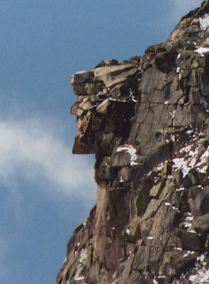
The Old Man of the Mountain, also called the Great Stone Face and the Profile, was a series of five granite cliff ledges on Cannon Mountain in Franconia, New Hampshire, United States, that appeared to be the jagged profile of a human face when viewed from the north. The rock formation, 1,200 feet (370 m) above Profile Lake, was 40 feet (12 m) tall and 25 feet (7.6 m) wide.

<span class="mw-page-title-main">Franconia Notch State Park</span> State park in New Hampshire, United States

Franconia Notch State Park is a public recreation area and nature preserve that straddles eight miles (13 km) of Interstate 93 as it passes through Franconia Notch, a mountain pass between the Kinsman Range and Franconia Range in the White Mountains of northern New Hampshire, United States. The northern part of the park, including Cannon Mountain and Echo and Profile lakes, is in the town of Franconia, and the southern part, including Lonesome Lake and the Flume, is in Lincoln. Attractions in the state park include the Flume Gorge and visitor center, the Old Man of the Mountain historical site, fishing in Echo Lake and Profile Lake, and miles of hiking, biking and ski trails.

<span class="mw-page-title-main">Franconia Notch</span>

Franconia Notch is a major mountain pass through the White Mountains of New Hampshire. Dominated by Cannon Mountain to the west and Mount Lafayette to the east, it lies principally within Franconia Notch State Park and is traversed by the Franconia Notch Parkway. The parkway required a special act of Congress to sidestep design standards for the Interstate highway system because it is only one lane in each direction.

<span class="mw-page-title-main">Mount Lafayette</span> Mountain in New Hampshire

Mount Lafayette is a 5,249-foot (1,600 m) mountain at the northern end of the Franconia Range in the White Mountains of New Hampshire, United States. It lies in the town of Franconia in Grafton County, and appears on the New England Fifty Finest list of the most topographically prominent peaks in New England. The mountain's upper reaches are located in the alpine zone, an area where only dwarf vegetation exists due to the harsh climate.

<span class="mw-page-title-main">Cannon Mountain (New Hampshire)</span>

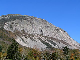
Cannon Mountain is a 4,080-foot (1,240 m) peak in the White Mountains of New Hampshire. It is known for both its technical rock and ice climbing on its cliff face and skiing at Cannon Mountain Ski Area. It was also home to the Old Man of the Mountain, until that formation collapsed on May 3, 2003.

<span class="mw-page-title-main">Mount Flume</span>

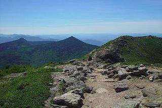
Mount Flume is a 4,328-foot (1,319 m) mountain at the southern end of the Franconia Range in the White Mountains of New Hampshire, United States. Mount Flume is the lowest in elevation of the peaks in the Franconia Range that are accessible by official hiking trails.

<span class="mw-page-title-main">White Mountain art</span> 19th-century art depicting New Hampshire, US

White Mountain art is the body of work created during the 19th century by over four hundred artists who painted landscape scenes of the White Mountains of New Hampshire in order to promote the region and, consequently, sell their works of art.

<span class="mw-page-title-main">Mount Liberty (New Hampshire)</span>

Mount Liberty is a 4,459-foot-high (1,359 m) mountain in the White Mountains of New Hampshire. Overlooking Franconia Notch, it is part of Franconia Ridge, the second highest mountain group in the Whites after the Presidential Range. It lies south of Mount Lafayette, the highest summit along the ridge, and is listed among the Appalachian Mountain Club's "four-thousand footers".

<span class="mw-page-title-main">Profile Lake</span>

Profile Lake is a 13-acre (53,000 m2) water body located in Franconia Notch in the White Mountains of New Hampshire, at the foot of Cannon Mountain. The lake was given its name due to its location directly beneath the Old Man of the Mountain, a famous rock formation which collapsed in 2003. The lake is near the height of land in Franconia Notch; the lake's outlet is the Pemigewasset River, which flows south to the Merrimack River and ultimately the Gulf of Maine at Newburyport, Massachusetts.

<span class="mw-page-title-main">Echo Lake (Franconia Notch)</span>

Echo Lake is a 38.2-acre (15.5 ha) water body located in Franconia Notch in the White Mountains of New Hampshire, at the foot of Cannon Mountain. The lake is in the Connecticut River watershed, near the height of land in Franconia Notch; water from the lake's outlet flows north via Lafayette Brook to the Gale River, then the Ammonoosuc River, and finally the Connecticut River to Long Island Sound, an arm of the Atlantic Ocean.

<span class="mw-page-title-main">Lonesome Lake (New Hampshire)</span>

Lonesome Lake is a 12.2-acre (49,000 m2) water body located in Franconia Notch in the White Mountains of New Hampshire, south of Cannon Mountain. The lake is reachable by hiking trails from the Franconia Notch Parkway, including the Lafayette Place Campground, and takes approximately 2–3 hours. It features an Appalachian Mountain Club hut, which first opened in 1930, on its southwest shore.

<span class="mw-page-title-main">Pemigewasset Wilderness</span>

The Pemigewasset Wilderness is a 45,000-acre (182 km2) federally designated Wilderness Area in the heart of New Hampshire's White Mountains. It is a part of the White Mountain National Forest. It is New Hampshire's largest wilderness area.

<span class="mw-page-title-main">Franconia Range</span>

The Franconia Range is a mountain range located in the White Mountains of the U.S. state of New Hampshire. It is the second-highest range of peaks in the White Mountains.

<span class="mw-page-title-main">Cannon Mountain Ski Area</span> Ski area in New Hampshire, United States

Cannon Mountain Ski Area is a state-owned ski resort located on Cannon Mountain in the White Mountains of New Hampshire, United States. Cannon is located within Franconia Notch State Park and offers 10 lifts servicing 265 acres (1.07 km2) of skiing. Cannon has 23 miles (37 km) of trails and a north-northeast exposure and has the only aerial tram in New Hampshire. Cannon has the most vertical of any ski area in New Hampshire, 2,180 feet (660 m), and is the seventh largest in New England. US Olympic skier Bode Miller grew up skiing at Cannon.

<span class="mw-page-title-main">Edward Hill (painter)</span> American painter and writer

Edward Hill was a prolific artist as well as a published poet, songwriter, and newspaper correspondent. His paintings include White Mountain landscapes, southern genre scenes, still lifes, portraits, American Indians, European attractions, and the scenery of the American West.

<span class="mw-page-title-main">Kinsman Range</span>

The Kinsman Range, also known as the Cannon–Kinsman Range, is a north–south range in the White Mountains of New Hampshire in the United States. Its highest point is 4,358-foot-high (1,328 m) Kinsman Mountain, followed by the 4,293-foot (1,309 m) North Peak of Kinsman, and 4,080-foot (1,240 m) Cannon Mountain, one of the richest in rock climbing routes in the Whites. All are official "Four-thousand footers". 3,478-foot (1,060 m) Mount Wolf is on the crest of the range south of Kinsman Mountain. Rounding out the range are 2,470-foot (750 m) Bald Peak on the west side of Kinsman Mountain and 2,530-foot (770 m) Mount Pemigewasset on the east side, overlooking Franconia Notch.

References

  1. "The Grand Hotels of New Hampshire", New Hampshire Notes
  2. "Profile House". www.whitemountainhistory.org. Archived from the original on 2011-02-21.
  3. 1 2 3 From hotels to hiking trail Parks and Recreation New Hampshire
  4. "Our History". 8 September 2014.

44°10′8″N71°41′11″W / 44.16889°N 71.68639°W / 44.16889; -71.68639