Air traffic control (ATC) is a service provided by ground-based air traffic controllers who direct aircraft on the ground and through a given section of controlled airspace, and can provide advisory services to aircraft in non-controlled airspace. The primary purpose of ATC worldwide is to prevent collisions, organize and expedite the flow of air traffic, and provide information and other support for pilots.
The Federal Aviation Regulations (FARs) are rules prescribed by the Federal Aviation Administration (FAA) governing all aviation activities in the United States. The FARs comprise Title 14 of the Code of Federal Regulations. A wide variety of activities are regulated, such as aircraft design and maintenance, typical airline flights, pilot training activities, hot-air ballooning, lighter-than-air aircraft, man-made structure heights, obstruction lighting and marking, model rocket launches, commercial space operations, model aircraft operations, Unmanned Aircraft Systems (UAS) and kite flying. The rules are designed to promote safe aviation, protecting pilots, flight attendants, passengers and the general public from unnecessary risk.
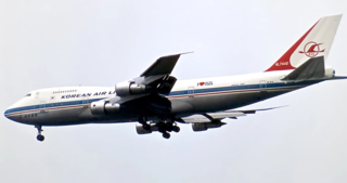
Korean Air Lines Flight 007 (KE007/KAL007) was a scheduled Korean Air Lines flight from New York City to Seoul via Anchorage, Alaska. On September 1, 1983, the flight was shot down by a Soviet Sukhoi Su-15 interceptor aircraft. The Boeing 747 airliner was en route from Anchorage to Seoul, but owing to a navigational mistake made by the crew, the airliner drifted from its original planned route and flew through Soviet prohibited airspace. The Soviet Air Forces treated the unidentified aircraft as an intruding U.S. spy plane, and destroyed it with air-to-air missiles, after firing warning shots. The Korean airliner eventually crashed into the sea near Moneron Island west of Sakhalin in the Sea of Japan. All 269 passengers and crew aboard were killed, including Larry McDonald, a United States representative. The Soviet Union found the wreckage under the sea two weeks later on September 15 and found the flight recorders in October, but this information was kept secret by the Soviet authorities until 1992, after the country's collapse.
Airspace is the portion of the atmosphere controlled by a country above its territory, including its territorial waters or, more generally, any specific three-dimensional portion of the atmosphere. It is not the same as outer space which is the expanse or space outside the Earth and aerospace which is the general term for Earth's atmosphere and the outer space within the planet's vicinity.
A no-fly zone, also known as a no-flight zone (NFZ), or air exclusion zone (AEZ), is a territory or area established by a military power over which certain aircraft are not permitted to fly. Such zones are usually set up in an enemy power's territory during a conflict for humanitarian or military reasons without consent of the enemy state, similar in concept to an aerial demilitarized zone, and usually intend to prohibit the enemy's military aircraft from operating in the region. Military action is employed by the enforcing state and, depending on the terms of the NFZ, may include preemptive attacks to prevent potential violations, reactive force targeted at violating aircraft, or surveillance with no use of force. Air exclusion zones and anti-aircraft defences are sometimes set up in a civilian context, for example to protect sensitive locations, or events such as the 2012 London Olympic Games, against terrorist air attack. A no-fly zone is generally not considered a form of aerial blockade due to its more limited scope compared to an aerial blockade.

An air defense identification zone (ADIZ) has existed since February 10, 2003, around the Baltimore-Washington Metropolitan Area to restrict air traffic near Washington, D.C.
The world's navigable airspace is divided into three-dimensional segments, each of which is assigned to a specific class. Most nations adhere to the classification specified by the International Civil Aviation Organization (ICAO) and described below, though they might use only some of the classes defined below, and significantly alter the exact rules and requirements. Similarly, individual nations may also designate special use airspace (SUA) with further rules for reasons of national security or safety.
A NOTAM is a notice filed with an aviation authority to alert aircraft pilots of potential hazards along a flight route or at a location that could affect the flight. NOTAMs are notices or advisories that contain information concerning the establishment, conditions or change in any aeronautical facility, service, procedure or hazard, the timely knowledge of which may be essential to personnel and systems concerned with flight operations.

Pilot certification in the United States is typically required for an individual to act as a pilot-in-command of an aircraft. It is regulated by the Federal Aviation Administration (FAA), a branch of the U.S. Department of Transportation (USDOT). A pilot may be certified under 14 Code of Federal Regulations (CFR) Part 61 or 14 CFR Part 141. Pilots may also be certified under 14 CFR Part 107 for commercial drone operations.

Canadian airspace is the region of airspace above the surface of the Earth within which Canada has jurisdiction. It falls within a region roughly defined as either the Canadian land mass, the Canadian Arctic or the Canadian archipelago, and areas of the high seas. Airspace is managed by Nav Canada and detailed information regarding exact dimensions and classification is available in the Designated Airspace Handbook which is published every fifty-six days by Nav Canada.
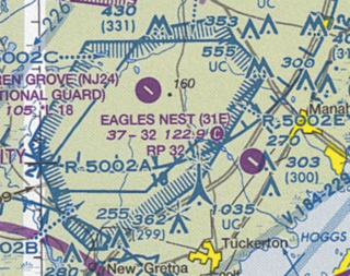
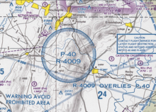
Restricted airspace is an area of airspace typically used by the military in which the local controlling authorities have determined that air traffic must be restricted or prohibited for safety or security concerns. It is one of many types of special use airspace designations and is depicted on aeronautical charts with the letter "R" followed by a serial number.
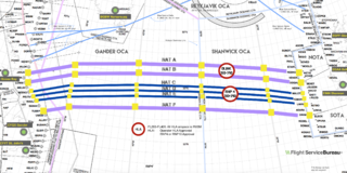
The North Atlantic Tracks, officially titled the North Atlantic Organised Track System (NAT-OTS), are a structured set of transatlantic flight routes that stretch from eastern North America to western Europe across the Atlantic Ocean, within the North Atlantic airspace region. They ensure that aircraft are separated over the ocean, where there is little radar coverage. These heavily travelled routes are used by aircraft flying between North America and Europe, operating between the altitudes of 29,000 and 41,000 ft inclusive. Entrance and movement along these tracks is controlled by special oceanic control centres to maintain separation between aircraft. The primary purpose of these routes is to allow air traffic control to effectively separate the aircraft. Because of the volume of NAT traffic, allowing aircraft to choose their own co-ordinates would make the ATC task far more complex. They are aligned in such a way as to minimize any head winds and maximize tail winds impact on the aircraft. This results in much more efficiency by reducing fuel burn and flight time. To make such efficiencies possible, the routes are created twice daily to take account of the shifting of the winds aloft and the principal traffic flow, eastward in North America evening and westward twelve hours later.
In aviation, a control zone (CTR) is a volume of controlled airspace, usually situated below a control area, normally around an airport, which extends from the surface to a specified upper limit, established to protect air traffic operating to and from that airport. Because CTRs are, by definition, controlled airspace, aircraft can only fly in them after receiving a specific clearance from air traffic control. This means that air traffic control at the airport know exactly which aircraft are in that airspace, and can take steps to ensure aircraft are aware of each other, either using separation or by passing traffic information.

Special use airspace (SUA) is a type of special airspaces in the United States designated for operations of a nature such that limitations may be imposed on aircraft not participating in those operations. Often these operations are of a military nature. The designation of SUAs identifies for other users the areas where such activity occurs, provides for segregation of that activity from other users, and allows charting to keep airspace users informed of potential hazards.

The United States airspace system's classification scheme is intended to maximize pilot flexibility within acceptable levels of risk appropriate to the type of operation and traffic density within that class of airspace – in particular to provide separation and active control in areas of dense or high-speed flight operations.
In United States aviation, a National Security Area (NSA) is a designated airspace through which flight is discouraged for reasons of national security.

The Air Defense Identification Zone of North America is an air defense identification zone (ADIZ) that covers the airspace surrounding the United States and Canada – in which the ready identification, location, and control of civil aircraft over land or water is required in the interest of national security. This ADIZ is jointly administered by the civilian air traffic control authorities and the militaries of both nations, under the auspices of the North American Aerospace Defense Command (NORAD). The Federal Aviation Administration (FAA) handles the requests of international aircraft and Transport Canada handles Canadian requests. Any aircraft flying in these zones without authorization may be identified as a threat and treated as an enemy aircraft, potentially leading to interception by fighter aircraft.
An air defense identification zone (ADIZ) is a region of airspace in which a country tries to identify, locate, and control aircraft in the interest of national security. It is declared unilaterally and may extend beyond a country's territory to give the country more time to respond to possibly hostile aircraft. The concept of an ADIZ is not defined in any international treaty and is not recognized by any international body.

Regulation of unmanned aerial vehicles (UAVs) involves setting safety requirements, outlining regulations for the safe flying of drones, and enforcing action against errant users.

The Paris International Air Navigation Conference of 1910, also known as the Conférence internationale de navigation aérienne, was the first diplomatic conference to consider formulating international law about aviation. It was proposed by the French government who were concerned about aircraft from foreign nations flying over their territory and was attended by representatives from 19 European nations.