
The Schneeberg, with its 2,076-metre (6,811 ft) high summit Klosterwappen, is the highest mountain of Lower Austria, and the easternmost mountain in the Alps to exceed 2000 m. It is a distinctive limestone massif with steep slopes on three sides.

Bad Ischl[baːt ˈɪʃl̩] is a spa town in Austria. It lies in the southern part of Upper Austria, at the Traun River in the centre of the Salzkammergut region. The town consists of the Katastralgemeinden Ahorn, Bad Ischl, Haiden, Jainzen, Kaltenbach, Lauffen, Lindau, Pfandl, Perneck, Reiterndorf and Rettenbach. It is connected to the village of Strobl by the river Ischl, which drains from the Wolfgangsee, and to the Traunsee, into which the stream empties. It is home to the Kaiservilla, summer residence of Austro-Hungarian monarchs Emperor Franz Joseph I and Empress Elisabeth. In 2024, Bad Ischl will be the European Capital of Culture – the third city in Austria after Graz (2003) and Linz (2009).

Laxenburg is a market town in the district of Mödling, in the Austrian state of Lower Austria. Located about 20 km (12 mi) south of the Austrian capital Vienna, it is chiefly known for the Laxenburg castles, which, beside Schönbrunn, served as the most important summer retreat of the Habsburg monarchs.
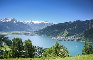
Zell am See is the administrative capital of the Zell am See District in the Austrian state of Salzburg. The town is an important tourist destination known as Zell am See-Kaprun and is a transportation hub for the region.

The Schneeberg Railway is one of three rack railways in Austria still operating, and runs from the small town of Puchberg am Schneeberg in Lower Austria up to a plateau beneath the Schneeberg summit. At 2,076 metres (6,811 ft), the Schneeberg is the highest mountain in Lower Austria. The other two working cog railways in Austria are the Schafberg Railway and the Achensee Railway.

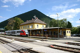
Gloggnitz is a mountain town in the Neunkirchen district of Lower Austria, Austria.

St. Wolfgang im Salzkammergut is a market town in central Austria, in the Salzkammergut region of Upper Austria, named after Saint Wolfgang of Regensburg.
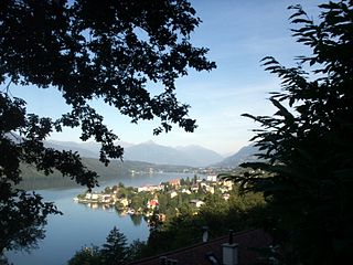
Millstatt am See is a market town of the Spittal an der Drau District in Carinthia, Austria. The traditional health resort and spa town on Lake Millstatt is known for former Benedictine Millstatt Abbey, founded about 1070.

Reichenau an der Rax is a market town in the Austrian state of Lower Austria, situated at the foot of the Rax mountain range on the Schwarza river, a headstream of the Leitha.

Krumpendorf am Wörthersee is a municipality in Klagenfurt-Land District, in Carinthia, Austria.

Pörtschach am Wörthersee is a municipality in the district of Klagenfurt-Land in Carinthia, Austria. It is an established summer resort and lakeside town on Wörthersee.

Heiligenblut am Großglockner is a municipality in the district of Spittal an der Drau in Carinthia, Austria.

Mannersdorf am Leithagebirge is a town in Austria. It is located in the district of Bruck an der Leitha in the state of Lower Austria. Mannersdorf is seated at the base of a range of wooded hills called the Leitha Mountains (Leithagebirge), from which it receives its full name. It overlooks an agricultural plain, through which flows the Leitha River, about two miles away.

Guntramsdorf is a town in the district of Mödling in the Austrian state of Lower Austria. As part of the "Industrieviertel", the industrial region in the southeast of Lower Austria, it is well connected to the country capital Vienna. The local rail service Badner Bahn connects Guntramsdorf with the central district of Vienna in the north and popular spa resort destination Baden bei Wien in the south. In the west of the town lies the Vienna Woods, an outlier of the Alpine foothills, featuring recreational forest areas and hiking trails, and the southeast of Guntramsdorf extends into the thermal Vienna Basin.
Straßwalchen is a market town in the district of Salzburg-Umgebung (Flachgau) in the state of Salzburg in Austria.

The Rax-Schneeberg Group is a mountain range in the Northern Limestone Alps on the Styrian-Lower Austrian border in Austria.
The Schneeberg Railway is a local railway line in Lower Austria running from Wiener Neustadt to the Hochschneeberg mountain. From Wiener Neustadt to Puchberg am Schneeberg it runs as a standard gauge, adhesion railway and from Puchberg am Schneeberg to the Hochschneeberg as a narrow-gauge, cog railway (extension). The main section from Wiener Neustadt to Puchberg am Schneeberg had a branch to Wöllersdorf from the outset. The section built later from Sollenau to Feuerwerksanstalt (extension) is now closed and renaturalised.
Vienna's Hausberge are the mountains of Raxalpe, Schneeberg and Hohe Wand in the south of the state of Lower Austria. These mountains may be reached from Vienna in about an hour and are therefore a popular recreation area for the Viennese.
Stainach-Pürgg is a municipality since 2015 in the Liezen District of Styria, Austria.
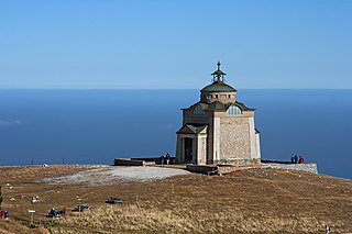
Empress Elisabeth Memorial Church is a small Roman Catholic church on the Schneeberg in Lower Austria. It is close to the mountain station of the Schneebergbahn. The memorial church belongs to the parish of Puchberg am Schneeberg and is the highest church of the Archdiocese of Vienna at an altitude of 1,796 metres (5,892 ft) above sea level.


