
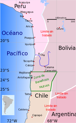
The Antofagasta Region is one of Chile's sixteen first-order administrative divisions. The second-largest region of Chile in area, it comprises three provinces, Antofagasta, El Loa and Tocopilla. It is bordered to the north by Tarapacá, by Atacama to the south, and to the east by Bolivia and Argentina. The region's capital is the port city of Antofagasta; another one of its important cities is Calama. The region's main economic activity is copper mining in its giant inland porphyry copper systems.
The War of the Pacific, also known as the Saltpeter War and by multiple other names, was a war between Chile and a Bolivian–Peruvian alliance from 1879 to 1884. Fought over Chilean claims on coastal Bolivian territory in the Atacama Desert, the war ended with a Chilean victory, which gained for the country a significant amount of resource-rich territory from Peru and Bolivia.

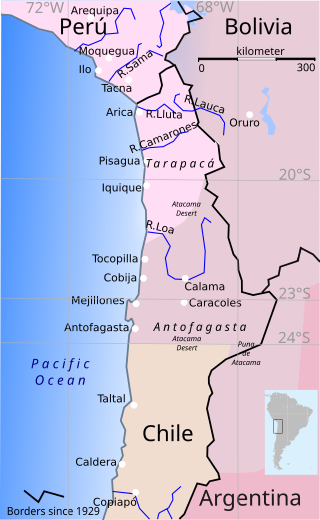
The Atacama Desert border dispute was a dispute between Bolivia and Chile from 1825 to 1879 for the territories of the Atacama Coast due to the different views of both countries of the territory inherited from the Spanish Empire. During the dispute, both countries signed Treaties in 1866 and 1874. The dispute occurred prior to the War of the Pacific, which settled the dispute in favor of Chile. Due to the surrender of land by Bolivia, the Puna de Atacama dispute was generated between Chile and Argentina and was settled in 1899.
Antofagasta Province is one of three provinces in the northern Chilean region of Antofagasta (II). The capital is the port city of Antofagasta. Located within the Atacama Desert, it borders the El Loa and Tocopilla provinces to the north, the Pacific Ocean to the West and the Atacama Region to the south.

International relations between the Republic of Chile and the Argentine Republic have existed for decades. The border between the two countries is the world's third-longest international border, which is 5,300 km (3,300 mi) long and runs from north to south along the Andes mountains. Although both countries gained their independence during the South American wars of liberation, during much of the 19th and the 20th century, relations between the countries were chilly as a result of disputes over the border in Patagonia. Despite this, Chile and Argentina have never been engaged in a war with each other. In recent years, relations have improved. Argentina and Chile have followed quite different economic policies. Chile has signed free trade agreements with countries such as China, the United States, the European Union, Canada, South Korea, and is a member of the APEC. Argentina belongs to the Mercosur regional free trade area. In April 2018, both countries suspended their membership from the UNASUR.
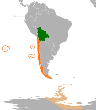
International relations between the Republic of Chile and the Plurinational State of Bolivia have been strained ever since independence in the early 19th century because of the Atacama border dispute. Relations soured even more after Bolivia lost its coast to Chile during the War of the Pacific and became a landlocked country. Chile and Bolivia have maintained only consular relations since 1978, when territorial negotiations failed and Bolivia decided to sever diplomatic relations with Chile. However, in spite of straining relationship, Chile and Bolivia still have economic treaties supporting tourism and cooperation; therefore, trading between two nations is not affected by the territorial dispute.

The Treaty of Peace and Friendship of 1984 between Chile and Argentina was signed into agreement at the Vatican on 29 November 1984.

The Puna de Atacama or Atacama Plateau is an arid high plateau, in the Andes of northern Chile (15%) and northwest of Argentina (85%). Geomorphologist Walther Penck based his Grossfalt landform association on Puna de Atacama.

The Boundary Treaty of 1881 between Argentina and Chile was signed on 23 July 1881 in Buenos Aires by Bernardo de Irigoyen, on the part of Argentina, and Francisco de Borja Echeverría, on the part of Chile, with the aim of establishing a precise and exact border between the two countries based on the uti possidetis juris principle. Despite dividing largely unexplored lands, the treaty laid the groundwork for nearly all of Chile's and Argentina's 5600 km current border.

The Department of the Litoral, also known as the Atacama Department and commonly known as the Bolivian coast, was the description of the extent of the Pacific coast of the Atacama Desert included in the territory of Bolivia from its inception in 1825 until 1879, when it was lost to Chile.

Amancio Alcorta was an Argentine legal theorist, conservative politician and diplomat.
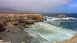
The Atacama Desert is the most arid desert in the world which is located in Chile.

Norberto Camilo Quirno Costa was an Argentine lawyer, politician, and diplomat.
The consequences of the War of the Pacific were profound and numerous in the countries involved.
The Treaty of Defensive Alliance was a secret defense pact between Bolivia and Peru. Signed in the Peruvian capital, Lima, on February 6, 1873, the document was composed of eleven central articles that outlined its necessity and stipulations and one additional article that ordered the treaty to be kept secret until both contracting parties decided otherwise. The signatory states were represented by the Peruvian Foreign Minister José de la Riva-Agüero y Looz Corswaren and the Bolivian Envoy Extraordinary and Minister Plenipotentiary in Peru, Juan de la Cruz Benavente.

The Argentina–Chile border is the longest international border of South America and the third longest in the world after the Canada–United States border and the Kazakhstan–Russia border. With a length of 5,308 kilometres (3,298 mi), it separates Argentina from Chile along the Andes and on the islands of Tierra del Fuego. However, there are some border disputes, particularly around the Southern Patagonian Ice Field. It is the largest border of the two countries, beating the Argentina–Paraguay and Chile–Bolivia, Argentina's and Chile's second largest borders, respectively.

Chilean expansionism refers to the foreign policy of Chile to expand its territorial control over key strategic locations and economic resources as a means to ensure its national security and assert its power in South America. Chile's significant territorial acquisitions, which occurred mostly throughout the 19th century, paved the way for its emergence as a thalassocracy and one of the three most powerful and wealthiest states in South America during the 20th century. It also formed Chile's geopolitical and national identity as a tricontinental state and one of the countries with the longest coastlines in the world.

The Tarija War, also known as the War between Argentina and the Peru–Bolivian Confederation, was an armed conflict that occurred between 1837 and 1839. Because it happened simultaneously when the Peru–Bolivian confederation was engaged in a parallel war against the Republic of Chile, in the so-called War of the Confederation, the first conflict referred here is often confused with the second. The war began on May 19, 1837, when the then in charge of managing foreign relations for the Argentine Confederation and governor of the Province of Buenos Aires, Juan Manuel de Rosas, declared war directly on President Andres de Santa Cruz, both for the Question of Tarija and its support for the Unitarian Party.

The Charaña Accord, also known as the Hug of Charaña or the Act of Charaña, is the name given to an unrealized treaty that was discussed between the dictators of Bolivia and Chile, Hugo Banzer and Augusto Pinochet respectively. These discussions took place mostly on the Bolivian train station of Charaña on February 8, 1975, and included the brief reestablishment of diplomatic relations between the two nations which had been severed on 1962 because of the Atacama border dispute which was to be solved via a Chilean proposal for the exchange of territories between Bolivia and Chile, with the former receiving a corridor to the Pacific Ocean which would provide it with access to the sea and Chile receiving an equivalent amount of territory from Bolivia along its border with Chile.

The South American territorial disputes are the territorial disputes and litigations that have developed in South America since the aftermath of the continent's wars of independence, which have shaped the current political geography of the region. These conflicts have been resolved both through both military and diplomatic means. The most recent conflict in the Americas of this nature was the Cenepa War in 1995, between Ecuador and Peru.


