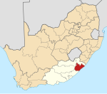
The Eastern Cape is one of the nine provinces of South Africa. Its capital is Bhisho, but its two largest cities are East London and Gqeberha.
Kokstad is a town in the Harry Gwala District Municipality of KwaZulu-Natal Province, South Africa. Kokstad is named after the Griqua chief Adam Kok III who settled here in 1863. Kokstad is the capital town of the East Griqualand region, as it is also the biggest town in this region. It was built around Mount Currie, a local mountain range, by the city's founder Adam Kok III, for whom the town is named. Stad is the Dutch and Afrikaans word for "city".

Mount Frere, officially KwaBhaca, is a town located in the Eastern Cape province, previously known as the Transkei region, of South Africa. Its name in Xhosa is KwaBhaca, or "village of the Bhaca chiefdom", or "place of the Bhaca people", who settled here around the year 1825.

The N2 is a national route in South Africa that runs from Cape Town through George, Gqeberha, East London, Mthatha, Port Shepstone and Durban to Ermelo. It is the main highway along the Indian Ocean coast of the country. Its current length of 2,255 kilometres (1,401 mi) makes it the longest numbered route in South Africa.

Mthatha ; Xhosa: [ḿ̩ˈtʰâːtʰà], alternatively rendered Umtata, is the main city of the King Sabata Dalindyebo Local Municipality in Eastern Cape province of South Africa and the capital of OR Tambo District Municipality. The city has an airport, previously known as the K. D. Matanzima Airport after former leader Kaiser Matanzima. Mthatha derives its name from the nearby Mthatha River which was named after the sneezewood (umtati) trees, famous for their wood and medicinal properties.
Kirkwood is a town in the Eastern Cape Province of South Africa. It is situated on the banks of the Sundays River in the eponymously named Sundays River Valley, which forms part of the Sundays River Valley Municipality in the Sarah Baartman District Municipality of the Eastern Cape.

The Chris Hani District Municipality is a landlocked district municipality situated in the centre of the Eastern Cape province of South Africa and is made up of eight local municipalities. Most of the communities are in rural areas. The landscape ranges from moist uplands and grassland hills to the arid Karoo scrubland.
Ngcobo, alternatively rendered Engcobo, is a town in the Eastern Cape province of South Africa.

Butterworth, also known as Gcuwa, is a town in the Eastern Cape Province, South Africa. Butterworth has a population of 45,900 and is situated on the N2 national highway 111 km north of East London.

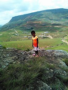
The Wild Coast is a section of the coast of the Eastern Cape, a province of South Africa. The region stretches from East London in the south to the border of KwaZulu-Natal in the north. It is the traditional home of the Mpondo people, and the birthplace of many prominent South Africans, including Nelson Mandela and Thabo Mbeki.
Libode is a small town of 5000 inhabitants in the Eastern Cape province of South Africa. It is situated on the R61 road from Port St Johns in the east to Mthatha in the west and serves as the administrative seat of the Nyandeni Local Municipality, which is part of the OR Tambo District Municipality. As a small infrastructural hub for the surrounding rural area, Libode features a community college and a hospital, the St Barnabas Hospital.
Coffee Bay is a town on the Wild Coast of the Eastern Cape Province of South Africa. It is located about 250 kilometres south-west of the city of Durban and has a population of 258 people.

Port St. Johns is a town of about 6,500 people on the Wild Coast in the Eastern Cape province of South Africa. It is situated at the mouth of the Umzimvubu River, 220 kilometres (140 mi) northeast of East London and 70 kilometres (40 mi) east of Mthatha. Port St. Johns was the Birthplace of Capital Radio 604.
Tsolo is a town in Mhlontlo Local Municipality in OR Tambo District of the Eastern Cape province of South Africa.

KwaZulu-Natal South Coast is a region along the southern stretch of coastline of KwaZulu-Natal, South Africa, south of the coastal city of Durban.

The Mpondomise people, also called AmaMpondomise, are a Xhosa-speaking people. Their traditional homeland has been in the contemporary era Eastern Cape province of South Africa, during apartheid they were located both in the Ciskei and Transkei region. Like other separate Xhosa-speaking kingdoms such as abaThembu and amaMpondo, they speak Xhosa and are at times considered as part of the Xhosa people.
Nolitha Ntobongwana is a South African educator and politician. She currently serves as the chairperson of the Portfolio Committee on Public Works and Infrastructure in the National Assembly. A member of the African National Congress, she has been a Member of Parliament since 2019. Ntobongwana had previously served in the Eastern Cape Provincial Legislature.
Mary Nombulelo Mabandla was a South African politician who represented the African National Congress (ANC) in the Eastern Cape Provincial Legislature from May 2009 until her death in September 2011. During that time, she served as the Eastern Cape's Member of the Executive Council (MEC) for Human Settlements between May 2009 and November 2010. Before her election to the provincial legislature, Mabandla was an ANC Youth League activist and a local councillor in Mhlontlo Local Municipality, her hometown.