Radcliffe, Iowa

Last updated
Radcliffe, Iowa
Hardin County Iowa Incorporated and Unincorporated areas Radcliffe Highlighted.svg
Location of Radcliffe, Iowa
Coordinates: 42°18′53″N93°25′56″W / 42.31472°N 93.43222°W / 42.31472; -93.43222 Coordinates: 42°18′53″N93°25′56″W / 42.31472°N 93.43222°W / 42.31472; -93.43222
Country Flag of the United States.svg  United States
State Flag of Iowa.svg  Iowa
County Hardin
Area
[1]
  Total1.00 sq mi (2.58 km2)
  Land1.00 sq mi (2.58 km2)
  Water0.00 sq mi (0.00 km2)
Elevation
1,184 ft (361 m)
Population
 (2020)
  Total555
  Density556.67/sq mi (215.01/km2)
Time zone UTC-6 (Central (CST))
  Summer (DST) UTC-5 (CDT)
ZIP code
50230
Area code 515
FIPS code 19-65370
GNIS feature ID0460495

Radcliffe is a city in Hardin County, Iowa, United States. The population was 555 at the time of the 2020 census. [2]

Contents

History

Radcliffe was laid out in 1880 when the railroad was extended to that point. [3] It was named after the novel The Heir of Redclyffe by Charlotte Mary Yonge. [4]

Geography

Radcliffe is located at 42°18′53″N93°25′56″W / 42.31472°N 93.43222°W / 42.31472; -93.43222 (42.314662, -93.432259). [5]

According to the United States Census Bureau, the city has a total area of 1.00 square mile (2.59 km2), all land. [6]

Demographics

Historical populations
YearPop.±%
1900 645    
1910 660+2.3%
1920 708+7.3%
1930 627−11.4%
1940 631+0.6%
1950 638+1.1%
1960 615−3.6%
1970 548−10.9%
1980 593+8.2%
1990 574−3.2%
2000 607+5.7%
2010 545−10.2%
2020 555+1.8%
Source: "U.S. Census website". United States Census Bureau . Retrieved 2020-03-29. and Iowa Data Center
Source:
U.S. Decennial Census [7] [2]

2010 census

As of the census [8] of 2010, there were 545 people, 243 households, and 157 families living in the city. The population density was 545.0 inhabitants per square mile (210.4/km2). There were 281 housing units at an average density of 281.0 per square mile (108.5/km2). The racial makeup of the city was 96.1% White, 0.2% Native American, 3.5% from other races, and 0.2% from two or more races. Hispanic or Latino of any race were 5.7% of the population.

There were 243 households, of which 28.0% had children under the age of 18 living with them, 56.4% were married couples living together, 3.7% had a female householder with no husband present, 4.5% had a male householder with no wife present, and 35.4% were non-families. 32.5% of all households were made up of individuals, and 20.1% had someone living alone who was 65 years of age or older. The average household size was 2.24 and the average family size was 2.83.

The median age in the city was 43.5 years. 23.9% of residents were under the age of 18; 4% were between the ages of 18 and 24; 23.1% were from 25 to 44; 26.1% were from 45 to 64; and 22.9% were 65 years of age or older. The gender makeup of the city was 48.8% male and 51.2% female.

2000 census

As of the census [9] of 2000, there were 607 people, 252 households, and 165 families living in the city. The population density was 604.3 inhabitants per square mile (233.3/km2). There were 273 housing units at an average density of 271.8 per square mile (104.9/km2). The racial makeup of the city was 96.38% White, 2.47% from other races, and 1.15% from two or more races. Hispanic or Latino of any race were 4.45% of the population.

There were 252 households, out of which 31.3% had children under the age of 18 living with them, 58.3% were married couples living together, 5.6% had a female householder with no husband present, and 34.5% were non-families. 31.0% of all households were made up of individuals, and 19.0% had someone living alone who was 65 years of age or older. The average household size was 2.41 and the average family size was 3.04.

25.9% were under the age of 18, 7.6% from 18 to 24, 27.5% from 25 to 44, 14.5% from 45 to 64, and 24.5% were 65 years of age or older. The median age was 38 years. For every 100 females, there were 91.5 males. For every 100 females age 18 and over, there were 91.5 males.

The median income for a household in the city was $39,417, and the median income for a family was $46,875. Males had a median income of $33,056 versus $22,188 for females. The per capita income for the city was $18,729. None of the families and 1.1% of the population were living below the poverty line, including no under eighteens and none of those over 64.

Education

Hubbard–Radcliffe Community School District is the area school district. The district formed on July 1, 1993, with the merger of the Hubbard and Radcliffe school districts. [10] As of 2019, it has a grade-sharing arrangement with Eldora–New Providence Community School District and operates as "South Hardin Schools".

Related Research Articles

<span class="mw-page-title-main">Hardin County, Iowa</span> County in Iowa, United States

Hardin County is a county located in the U.S. state of Iowa. As of the 2020 census, the population was 16,878. The county seat is Eldora. The county was named in honor of Col. John J. Hardin, of Illinois, who was killed in the Mexican–American War.

<span class="mw-page-title-main">New Hampton, Iowa</span> City in Iowa, United States

New Hampton is a city in, and the county seat of, Chickasaw County, Iowa, United States. The population was 3,494 at the time of the 2020 census.

<span class="mw-page-title-main">Superior, Iowa</span> City in Iowa, United States

Superior is a city in Dickinson County, Iowa, United States. The population was 132 at the time of the 2020 census.

<span class="mw-page-title-main">Eldora, Iowa</span> City in Iowa, United States

Eldora is a city in Hardin County, Iowa, United States. The population was 2,663 at the time of the 2020 census. It is the county seat of Hardin County.

<span class="mw-page-title-main">Hubbard, Iowa</span> City in Iowa, United States

Hubbard is a city in Hardin County, Iowa, United States. The population was 860 at the time of the 2020 census.

<span class="mw-page-title-main">New Providence, Iowa</span> City in Iowa, United States

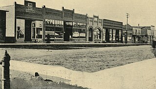
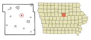
New Providence is a small city in Hardin County, Iowa, United States. The population was 236 at the time of the 2020 census.

<span class="mw-page-title-main">Owasa, Iowa</span> City in Iowa, United States

Owasa is a city in Hardin County, Iowa, United States. The population was 34 at the time of the 2020 census.

<span class="mw-page-title-main">Union, Iowa</span> City in Iowa, United States

Union is a city in Hardin County, Iowa, United States. The population was 399 at the time of the 2020 census.

<span class="mw-page-title-main">Cunningham, Kansas</span> City in Kingman County, Kansas

Cunningham is a city in Kingman County, Kansas, United States. As of the 2020 census, the population of the city was 444. The city was named in honor of J.D. Cunningham, a pioneer settler.

<span class="mw-page-title-main">Clifford, Michigan</span> Village in Michigan, United States

Clifford is a village in Lapeer County of the U.S. state of Michigan. The population was 324 at the 2010 census. The village is within Burlington Township.

<span class="mw-page-title-main">Crystal Lake Park, Missouri</span> City in Missouri, United States

Crystal Lake Park is a Missouri Class 4 city in St. Louis County, Missouri, United States. The population was 508 at the 2020 census.

<span class="mw-page-title-main">Hardin, Montana</span> City in Montana, United States

Hardin is a city in and the county seat of Big Horn County, Montana, United States. The population was 3,818 at the 2020 census.

<span class="mw-page-title-main">Potter, Nebraska</span> Village in Nebraska, United States

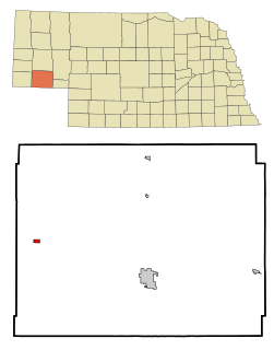
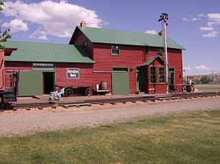
Potter is a village in Cheyenne County, Nebraska, United States. As of the 2010 census, the village population was 337.

<span class="mw-page-title-main">Stanley, North Dakota</span> City in North Dakota, United States

Stanley is a city in Mountrail County, North Dakota, United States. It is the county seat of Mountrail County. The population was 2,321 at the 2020 census, making it the 21st largest city in North Dakota. Stanley was founded in 1902. The town's economy is heavily connected to the nearby oil-rich Bakken Formation.

<span class="mw-page-title-main">Lankin, North Dakota</span> City in North Dakota, United States

Lankin is a city in Walsh County, North Dakota, United States. The population was 102 at the 2020 census. Lankin was founded in 1905.

<span class="mw-page-title-main">South Russell, Ohio</span> Village in Ohio, United States

South Russell is a village in Geauga County, Ohio, United States. The population was 3,819 at the 2010 census.

<span class="mw-page-title-main">Forest, Ohio</span> Village in Ohio, United States

Forest is a village in Hardin and Wyandot counties in the U.S. state of Ohio. The population was 1,461 at the 2010 census.

<span class="mw-page-title-main">Richmond, Ohio</span> Village in Ohio, United States

Richmond is a village in central Jefferson County, Ohio, United States. The population was 412 at the 2020 census. It is part of the Weirton–Steubenville metropolitan area.

<span class="mw-page-title-main">Unity, Wisconsin</span> Village in Wisconsin, United States

Unity is a village in Clark and Marathon counties in the U.S. state of Wisconsin. It is part of the Wausau, Wisconsin Metropolitan Statistical Area. The population was 343 at the 2010 census. Of this, 204 were in Marathon County, and 139 were in Clark County. The village is located in northeastern town of Unity in Clark County and northwestern town of Brighton in Marathon County.

<span class="mw-page-title-main">Alden, Iowa</span> City in Iowa, United States

Alden is a city in Hardin County, Iowa, United States. The population was 763 at the 2020 census.

References

  1. "2020 U.S. Gazetteer Files". United States Census Bureau. Retrieved March 16, 2022.
  2. 1 2 "2020 Census State Redistricting Data". census.gov. United states Census Bureau. Retrieved 12 August 2021.
  3. History of Hardin County, Iowa. Union Publishing Company. 1883. p.  906.
  4. Chicago and North Western Railway Company (1908). A History of the Origin of the Place Names Connected with the Chicago & North Western and Chicago, St. Paul, Minneapolis & Omaha Railways. p. 116.
  5. "US Gazetteer files: 2010, 2000, and 1990". United States Census Bureau. 2011-02-12. Retrieved 2011-04-23.
  6. "US Gazetteer files 2010". United States Census Bureau. Archived from the original on 2012-07-02. Retrieved 2012-05-11.
  7. "Census of Population and Housing". Census.gov. Retrieved June 4, 2015.
  8. "U.S. Census website". United States Census Bureau . Retrieved 2012-05-11.
  9. "U.S. Census website". United States Census Bureau . Retrieved 2008-01-31.
  10. "REORGANIZATION & DISSOLUTION ACTIONS SINCE 1965-66." Iowa Department of Education. Retrieved on July 20, 2018.